
Tönning - Husum, by Braun & Hogenberg. 1596-1640
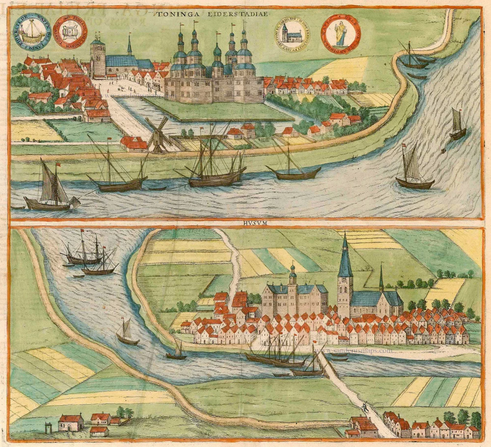
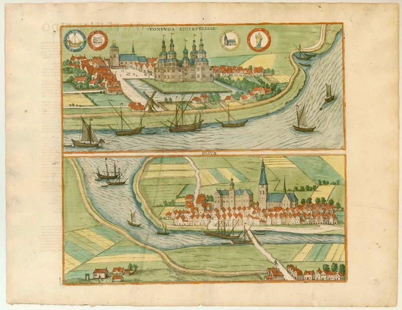

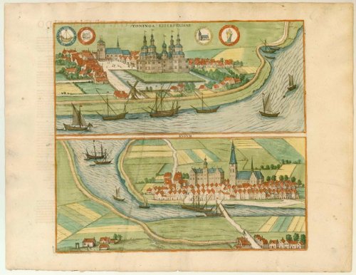
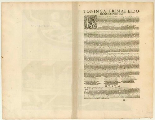
TÖNNING
COMMENTARY BY BRAUN (on verso): "Tönning lies in a region so fertile that even the Dutch consider it unusual for their country. The animals there, such as the oxen and cows, are so big that you will not find them like anywhere else in Christendom, and one cow there give nine measures daily, that is, 36 Lübeck pounds of milk. From this, over 23 times 100,000 pounds of cheese can be exported by boat between 1 May and the last day of September."
The illustration of Tönning shows a view across the Eider. Duke Adolf of Schleswig-Holstein-Gottorp built the castle with five towers at the centre of the town from 1580 to 1583; it was destroyed in 1735. Beside it to the left is the church of St Lawrence, founded in 1186. Tönning is first mentioned in records in 1137 and was granted its charter in 1590. Due to its position on the River Eider, which leads out to the North Sea, Tönning was a major commercial port dealing not just in cheese but also in wheat, cattle and other goods.
HUSUM
COMMENTARY BY BRAUN: "For a part of the sea, called the Hever, flows past Husum, so that from there it is easy to ship to Holland, Zeeland, England and Scotland and to import all sorts of commercial goods and in Flensburg to transport them from the Baltic to the North Sea, which lies only eight miles away."
Husum is shown from the cavalier perspective of the south. On the left, beside the Gothic church of St Mary, stands the castle built by Duke Adolf I from 1577 to 1582, a three-wing complex with a distinctive middle tower. Husum arose from a prehistoric settlement but is first mentioned in records as late as 1252. In 1362 a large section of the coast was hit by a great flood known as the Grote Mandränke, which left Husum with direct access to the sea. In 1465 Husum took part in a revolt against the Danish king Christian I and was awarded its long-desired charter only in 1603. In another storm tide in 1634, Husum lost its grain reserves, and the town's economic importance waned. (Taschen)
Braun G. & Hogenberg F. and the Civitates Orbis Terrarum.
The Civitates Orbis Terrarum, also known as the 'Braun & Hogenberg', is a six-volume town atlas and the most excellent book of town views and plans ever published: 363 engravings, sometimes beautifully coloured. It was one of the best-selling works in the last quarter of the 16th century. Georg Braun, a skilled writer, wrote the text accompanying the plans and views on the verso. Many plates were engraved after the original drawings of a professional artist, Joris Hoefnagel (1542-1600). The first volume was published in Latin in 1572 and the sixth in 1617. Frans Hogenberg, a talented engraver, created the tables for volumes I through IV, and Simon van den Neuwel made those for volumes V and VI. Other contributors were cartographers Daniel Freese and Heinrich Rantzau, who provided valuable geographical information. Works by Jacob van Deventer, Sebastian Münster, and Johannes Stumpf were also used as references. Translations appeared in German and French, making the atlas accessible to a broader audience.
Since its original publication of volume 1 in 1572, the Civitates Orbis Terrarum has left an indelible mark on the history of cartography. Seven more editions followed the first volume in 1575, 1577, 1582, 1588, 1593, 1599, and 1612. Vol.2, initially released in 1575, saw subsequent editions in 1597 and 1612. The subsequent volumes, each a treasure trove of historical insights, graced the world in 1581, 1588, 1593, 1599, and 1606. The German translation of the first volume, a testament to its widespread appeal, debuted in 1574, followed by the French edition in 1575.
Several printers were involved: Theodor Graminaeus, Heinrich von Aich, Gottfried von Kempen, Johannis Sinniger, Bertram Buchholtz, and Peter von Brachel, all of whom worked in Cologne.
Georg Braun (1541-1622)
Georg Braun, the author of the text accompanying the plans and views in the Civitates Orbis Terrarum, was born in Cologne in 1541. After his studies in Cologne, he entered the Jesuit Order as a novice, indicating his commitment to learning and intellectual pursuits. In 1561, he obtained his bachelor's degree; in 1562, he received his Magister Artium, further demonstrating his academic achievements. Although he left the Jesuit Order, he continued his studies in theology, gaining a licentiate in theology. His theological background likely influenced the content and tone of the text in the Civitates Orbis Terrarum, adding a unique perspective to the work.
Frans Hogenberg (1535-1590)
Frans Hogenberg was a Flemish and German painter, engraver, and mapmaker. He was born in Mechelen as the son of Nicolaas Hogenberg.
By the end of the 1560s, Frans Hogenberg was employed upon Abraham Ortelius's Theatrum Orbis Terrarum, published in 1570; he is named an engraver of numerous maps. In 1568, he was banned from Antwerp by the Duke of Alva and travelled to London, where he stayed a few years before emigrating to Cologne. He immediately embarked on his two most important works, the Civitates, published in 1572 and the Geschichtsblätter, which appeared in several series from 1569 until about 1587.
Thanks to large-scale projects like the Geschichtsblätter and the Civitates, Hogenberg's social circumstances improved with each passing year. He died as a wealthy man in Cologne in 1590.
Toninga Eiderstadiae [on sheet with:] Husum.
Item Number: 22087 Authenticity Guarantee
Category: Antique maps > Europe > Germany - Cities
Antique map with two bird's-eye views by Braun and Hogenberg: Tönning and Husum.
Antique map of Tönning - Husum by Braun & Hogenberg.
Title: Toninga Eiderstadiae [on sheet with:] Husum.
Date of the first edition: 1596.
Date of this map: 1596-1640.
Copper engraving, printed on paper.
Size (not including margins): 363 x 400mm (14.29 x 15.75 inches).
Verso: Latin text.
Condition: Original coloured, printer's crease in lower view, some shine-through of verso text.
Condition Rating: B+.
From: Civitates Orbis Terrarum, ... Part 5. Köln, 1596-1640.
TÖNNING
COMMENTARY BY BRAUN (on verso): "Tönning lies in a region so fertile that even the Dutch consider it unusual for their country. The animals there, such as the oxen and cows, are so big that you will not find them like anywhere else in Christendom, and one cow there give nine measures daily, that is, 36 Lübeck pounds of milk. From this, over 23 times 100,000 pounds of cheese can be exported by boat between 1 May and the last day of September."
The illustration of Tönning shows a view across the Eider. Duke Adolf of Schleswig-Holstein-Gottorp built the castle with five towers at the centre of the town from 1580 to 1583; it was destroyed in 1735. Beside it to the left is the church of St Lawrence, founded in 1186. Tönning is first mentioned in records in 1137 and was granted its charter in 1590. Due to its position on the River Eider, which leads out to the North Sea, Tönning was a major commercial port dealing not just in cheese but also in wheat, cattle and other goods.
HUSUM
COMMENTARY BY BRAUN: "For a part of the sea, called the Hever, flows past Husum, so that from there it is easy to ship to Holland, Zeeland, England and Scotland and to import all sorts of commercial goods and in Flensburg to transport them from the Baltic to the North Sea, which lies only eight miles away."
Husum is shown from the cavalier perspective of the south. On the left, beside the Gothic church of St Mary, stands the castle built by Duke Adolf I from 1577 to 1582, a three-wing complex with a distinctive middle tower. Husum arose from a prehistoric settlement but is first mentioned in records as late as 1252. In 1362 a large section of the coast was hit by a great flood known as the Grote Mandränke, which left Husum with direct access to the sea. In 1465 Husum took part in a revolt against the Danish king Christian I and was awarded its long-desired charter only in 1603. In another storm tide in 1634, Husum lost its grain reserves, and the town's economic importance waned. (Taschen)
Braun G. & Hogenberg F. and the Civitates Orbis Terrarum.
The Civitates Orbis Terrarum, also known as the 'Braun & Hogenberg', is a six-volume town atlas and the most excellent book of town views and plans ever published: 363 engravings, sometimes beautifully coloured. It was one of the best-selling works in the last quarter of the 16th century. Georg Braun, a skilled writer, wrote the text accompanying the plans and views on the verso. Many plates were engraved after the original drawings of a professional artist, Joris Hoefnagel (1542-1600). The first volume was published in Latin in 1572 and the sixth in 1617. Frans Hogenberg, a talented engraver, created the tables for volumes I through IV, and Simon van den Neuwel made those for volumes V and VI. Other contributors were cartographers Daniel Freese and Heinrich Rantzau, who provided valuable geographical information. Works by Jacob van Deventer, Sebastian Münster, and Johannes Stumpf were also used as references. Translations appeared in German and French, making the atlas accessible to a broader audience.
Since its original publication of volume 1 in 1572, the Civitates Orbis Terrarum has left an indelible mark on the history of cartography. Seven more editions followed the first volume in 1575, 1577, 1582, 1588, 1593, 1599, and 1612. Vol.2, initially released in 1575, saw subsequent editions in 1597 and 1612. The subsequent volumes, each a treasure trove of historical insights, graced the world in 1581, 1588, 1593, 1599, and 1606. The German translation of the first volume, a testament to its widespread appeal, debuted in 1574, followed by the French edition in 1575.
Several printers were involved: Theodor Graminaeus, Heinrich von Aich, Gottfried von Kempen, Johannis Sinniger, Bertram Buchholtz, and Peter von Brachel, all of whom worked in Cologne.
Georg Braun (1541-1622)
Georg Braun, the author of the text accompanying the plans and views in the Civitates Orbis Terrarum, was born in Cologne in 1541. After his studies in Cologne, he entered the Jesuit Order as a novice, indicating his commitment to learning and intellectual pursuits. In 1561, he obtained his bachelor's degree; in 1562, he received his Magister Artium, further demonstrating his academic achievements. Although he left the Jesuit Order, he continued his studies in theology, gaining a licentiate in theology. His theological background likely influenced the content and tone of the text in the Civitates Orbis Terrarum, adding a unique perspective to the work.
Frans Hogenberg (1535-1590)
Frans Hogenberg was a Flemish and German painter, engraver, and mapmaker. He was born in Mechelen as the son of Nicolaas Hogenberg.
By the end of the 1560s, Frans Hogenberg was employed upon Abraham Ortelius's Theatrum Orbis Terrarum, published in 1570; he is named an engraver of numerous maps. In 1568, he was banned from Antwerp by the Duke of Alva and travelled to London, where he stayed a few years before emigrating to Cologne. He immediately embarked on his two most important works, the Civitates, published in 1572 and the Geschichtsblätter, which appeared in several series from 1569 until about 1587.
Thanks to large-scale projects like the Geschichtsblätter and the Civitates, Hogenberg's social circumstances improved with each passing year. He died as a wealthy man in Cologne in 1590.