
Neuss, Bonn, Brühl and Zons, by Georg Braun and Frans Hogenberg. 1575

NEUSS
CARTOUCHE: Novesium, in German Neuss, a Rhenish city of the Ubii, drawn true to nature in the year of our Lord 1575.
COMMENTARY BY BRAUN: "Neuss lies four miles from Cologne; it is the site of a monastery and a convent, which is very famous because of the relics of St Quirinus, which are venerated there."
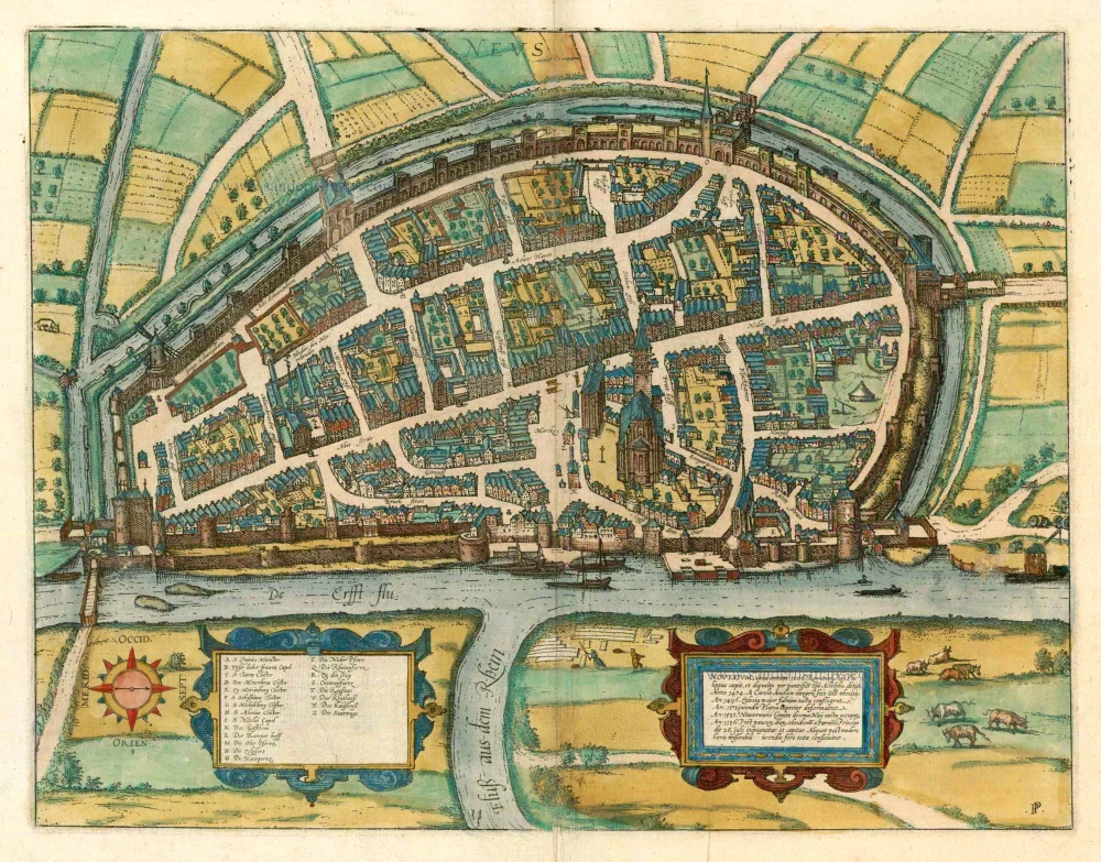
BONN
CARTOUCHE: Verona, commonly known today as Bonna; Bonn. Famous town on the Rhine above Cologne. 1575.
COMMENTARY BY BRAUN: "Bonn is a small town; the surrounding farmland is fertile for grain and wine, here the air has always been healthy, for this reason the nobility and the elector and archbishop of Cologne have resided here since the old days. The city has a very large marketplace with a beautiful fountain in the middle of it."
This view of the Rhine front from the right bank shows Bonn in the 16th century, when it had about 4,000 inhabitants. On the left Bonn's Romanesque minster (St Martin's) can be seen, which was built in the 11th century as the collegiate church of SS Cassius and Florentius for the Cassius foundation. In 1597 Bonn became the residence and capital of the electors and archbishops of Cologne; the cityscape is characterized by the stately buildings from this era.
BRÜHL
CARTOUCHE: Brula, in the local dialect Broell. 1575.
COMMENTARY BY BRAUN: "In Brühl, partly because of the charm of the region, but also because of a dispute with Cologne, the bishop of Cologne, Siegfried von Westenburg, built a castle and surrounded it with such sturdy walls that it was able to withstand a siege for four months in 1318. Since this time Brühl has generally been the seat of the electors of Cologne."
This view shows the city of Brühl, which was created capital of the Electorate of Cologne by Elector Rupert in 1469. The viewer's attention is drawn directly to the moated castle that was erected in 1284 by the Archbishop Siegfried of Cologne, as a bulwark against the city of Cologne, and which was reinforced during the following decades. The castle remained unchanged until 1689, when it was blown up by the French. Today, the palace of Augustusburg and the Falkenlust hunting lodge, both built in the 18th century, stand on the site of the former moated castle.
ZONS
CARTOUCHE: Zons, town in the bank of the Rhine, known as a customs station. In the year 1575.
COMMENTARY BY BRAUN: "Zons is a charming little town on the left bank of the Rhine, which gained importance because of the Rhine and the toll station. Most of the inhabitants are farmers, for the land is good and yields abundant grain. The castle here was built by Bishop Siegffried."
This old Cologne customs stronghold is shown from the right bank of the Rhine, and the magnificent castle, built in the 14th-15th centuries, is depicted on the far left. When the Rhine toll was moved here in 1372, the fortifications were extended, and the town was laid out in rectangular form with fortified towers at each corner. Archbishop Dietrich II von Moers gave the little town as a pledge to the Cologne cathedral chapter in the 15th century. The architectural history of Zons has been much affected by three devastating fires (1464, 1547 and 1620).
Braun G. & Hogenberg F. and the Civitates Orbis Terrarum.
The Civitates Orbis Terrarum, also known as the 'Braun & Hogenberg', is a six-volume town atlas and the most excellent book of town views and plans ever published: 363 engravings, sometimes beautifully coloured. It was one of the best-selling works in the last quarter of the 16th century. Georg Braun, a skilled writer, wrote the text accompanying the plans and views on the verso. Many plates were engraved after the original drawings of a professional artist, Joris Hoefnagel (1542-1600). The first volume was published in Latin in 1572 and the sixth in 1617. Frans Hogenberg, a talented engraver, created the tables for volumes I through IV, and Simon van den Neuwel made those for volumes V and VI. Other contributors were cartographers Daniel Freese and Heinrich Rantzau, who provided valuable geographical information. Works by Jacob van Deventer, Sebastian Münster, and Johannes Stumpf were also used as references. Translations appeared in German and French, making the atlas accessible to a broader audience.
Since its original publication of volume 1 in 1572, the Civitates Orbis Terrarum has left an indelible mark on the history of cartography. Seven more editions followed the first volume in 1575, 1577, 1582, 1588, 1593, 1599, and 1612. Vol.2, initially released in 1575, saw subsequent editions in 1597 and 1612. The subsequent volumes, each a treasure trove of historical insights, graced the world in 1581, 1588, 1593, 1599, and 1606. The German translation of the first volume, a testament to its widespread appeal, debuted in 1574, followed by the French edition in 1575.
Several printers were involved: Theodor Graminaeus, Heinrich von Aich, Gottfried von Kempen, Johannis Sinniger, Bertram Buchholtz, and Peter von Brachel, all of whom worked in Cologne.
Georg Braun (1541-1622)
Georg Braun, the author of the text accompanying the plans and views in the Civitates Orbis Terrarum, was born in Cologne in 1541. After his studies in Cologne, he entered the Jesuit Order as a novice, indicating his commitment to learning and intellectual pursuits. In 1561, he obtained his bachelor's degree; in 1562, he received his Magister Artium, further demonstrating his academic achievements. Although he left the Jesuit Order, he continued his studies in theology, gaining a licentiate in theology. His theological background likely influenced the content and tone of the text in the Civitates Orbis Terrarum, adding a unique perspective to the work.
Frans Hogenberg (1535-1590)
Frans Hogenberg was a Flemish and German painter, engraver, and mapmaker. He was born in Mechelen as the son of Nicolaas Hogenberg.
By the end of the 1560s, Frans Hogenberg was employed upon Abraham Ortelius's Theatrum Orbis Terrarum, published in 1570; he is named an engraver of numerous maps. In 1568, he was banned from Antwerp by the Duke of Alva and travelled to London, where he stayed a few years before emigrating to Cologne. He immediately embarked on his two most important works, the Civitates, published in 1572 and the Geschichtsblätter, which appeared in several series from 1569 until about 1587.
Thanks to large-scale projects like the Geschichtsblätter and the Civitates, Hogenberg's social circumstances improved with each passing year. He died as a wealthy man in Cologne in 1590.
Novesium vulgo Neus ... [on sheet with:] Verona, nunc Bonna, ... [and] Brula, vulgari idiomate Broell; 1575. [and] Sontina, Zunss Oppidum ad Rheni ripas, ...
Item Number: 8145 Authenticity Guarantee
Category: Antique maps > Europe > Germany - Cities
Old, antique bird’s-eye view plan of Neuss, Bonn, Brühl and Zons, by Georg Braun and Frans Hogenberg.
Title: Novesium vulgo Neus ... [on sheet with:] Verona, nunc Bonna, ... [and] Brula, vulgari idiomate Broell; 1575. [and] Sontina, Zunss Oppidum ad Rheni ripas, ...
Date of the first edition: 1575.
Date of this map: 1575.
Copper engraving, printed on paper.
Size (not including margins): 320 x 463mm (12.6 x 18.23 inches).
Verso: Latin text.
Condition: Uncoloured, some light browning along centrefold.
Condition Rating: A.
From: Civitates Orbis Terrarum, ... Part 2: De Praecipuis, Totius Universi Urbibus, Liber Secundus. Köln, Gottfried von Kempen, 1575. (Van der Krogt 4, 41:1.2)
NEUSS
CARTOUCHE: Novesium, in German Neuss, a Rhenish city of the Ubii, drawn true to nature in the year of our Lord 1575.
COMMENTARY BY BRAUN: "Neuss lies four miles from Cologne; it is the site of a monastery and a convent, which is very famous because of the relics of St Quirinus, which are venerated there."
BONN
CARTOUCHE: Verona, commonly known today as Bonna; Bonn. Famous town on the Rhine above Cologne. 1575.
COMMENTARY BY BRAUN: "Bonn is a small town; the surrounding farmland is fertile for grain and wine, here the air has always been healthy, for this reason the nobility and the elector and archbishop of Cologne have resided here since the old days. The city has a very large marketplace with a beautiful fountain in the middle of it."
This view of the Rhine front from the right bank shows Bonn in the 16th century, when it had about 4,000 inhabitants. On the left Bonn's Romanesque minster (St Martin's) can be seen, which was built in the 11th century as the collegiate church of SS Cassius and Florentius for the Cassius foundation. In 1597 Bonn became the residence and capital of the electors and archbishops of Cologne; the cityscape is characterized by the stately buildings from this era.
BRÜHL
CARTOUCHE: Brula, in the local dialect Broell. 1575.
COMMENTARY BY BRAUN: "In Brühl, partly because of the charm of the region, but also because of a dispute with Cologne, the bishop of Cologne, Siegfried von Westenburg, built a castle and surrounded it with such sturdy walls that it was able to withstand a siege for four months in 1318. Since this time Brühl has generally been the seat of the electors of Cologne."
This view shows the city of Brühl, which was created capital of the Electorate of Cologne by Elector Rupert in 1469. The viewer's attention is drawn directly to the moated castle that was erected in 1284 by the Archbishop Siegfried of Cologne, as a bulwark against the city of Cologne, and which was reinforced during the following decades. The castle remained unchanged until 1689, when it was blown up by the French. Today, the palace of Augustusburg and the Falkenlust hunting lodge, both built in the 18th century, stand on the site of the former moated castle.
ZONS
CARTOUCHE: Zons, town in the bank of the Rhine, known as a customs station. In the year 1575.
COMMENTARY BY BRAUN: "Zons is a charming little town on the left bank of the Rhine, which gained importance because of the Rhine and the toll station. Most of the inhabitants are farmers, for the land is good and yields abundant grain. The castle here was built by Bishop Siegffried."
This old Cologne customs stronghold is shown from the right bank of the Rhine, and the magnificent castle, built in the 14th-15th centuries, is depicted on the far left. When the Rhine toll was moved here in 1372, the fortifications were extended, and the town was laid out in rectangular form with fortified towers at each corner. Archbishop Dietrich II von Moers gave the little town as a pledge to the Cologne cathedral chapter in the 15th century. The architectural history of Zons has been much affected by three devastating fires (1464, 1547 and 1620).
Braun G. & Hogenberg F. and the Civitates Orbis Terrarum.
The Civitates Orbis Terrarum, also known as the 'Braun & Hogenberg', is a six-volume town atlas and the most excellent book of town views and plans ever published: 363 engravings, sometimes beautifully coloured. It was one of the best-selling works in the last quarter of the 16th century. Georg Braun, a skilled writer, wrote the text accompanying the plans and views on the verso. Many plates were engraved after the original drawings of a professional artist, Joris Hoefnagel (1542-1600). The first volume was published in Latin in 1572 and the sixth in 1617. Frans Hogenberg, a talented engraver, created the tables for volumes I through IV, and Simon van den Neuwel made those for volumes V and VI. Other contributors were cartographers Daniel Freese and Heinrich Rantzau, who provided valuable geographical information. Works by Jacob van Deventer, Sebastian Münster, and Johannes Stumpf were also used as references. Translations appeared in German and French, making the atlas accessible to a broader audience.
Since its original publication of volume 1 in 1572, the Civitates Orbis Terrarum has left an indelible mark on the history of cartography. Seven more editions followed the first volume in 1575, 1577, 1582, 1588, 1593, 1599, and 1612. Vol.2, initially released in 1575, saw subsequent editions in 1597 and 1612. The subsequent volumes, each a treasure trove of historical insights, graced the world in 1581, 1588, 1593, 1599, and 1606. The German translation of the first volume, a testament to its widespread appeal, debuted in 1574, followed by the French edition in 1575.
Several printers were involved: Theodor Graminaeus, Heinrich von Aich, Gottfried von Kempen, Johannis Sinniger, Bertram Buchholtz, and Peter von Brachel, all of whom worked in Cologne.
Georg Braun (1541-1622)
Georg Braun, the author of the text accompanying the plans and views in the Civitates Orbis Terrarum, was born in Cologne in 1541. After his studies in Cologne, he entered the Jesuit Order as a novice, indicating his commitment to learning and intellectual pursuits. In 1561, he obtained his bachelor's degree; in 1562, he received his Magister Artium, further demonstrating his academic achievements. Although he left the Jesuit Order, he continued his studies in theology, gaining a licentiate in theology. His theological background likely influenced the content and tone of the text in the Civitates Orbis Terrarum, adding a unique perspective to the work.
Frans Hogenberg (1535-1590)
Frans Hogenberg was a Flemish and German painter, engraver, and mapmaker. He was born in Mechelen as the son of Nicolaas Hogenberg.
By the end of the 1560s, Frans Hogenberg was employed upon Abraham Ortelius's Theatrum Orbis Terrarum, published in 1570; he is named an engraver of numerous maps. In 1568, he was banned from Antwerp by the Duke of Alva and travelled to London, where he stayed a few years before emigrating to Cologne. He immediately embarked on his two most important works, the Civitates, published in 1572 and the Geschichtsblätter, which appeared in several series from 1569 until about 1587.
Thanks to large-scale projects like the Geschichtsblätter and the Civitates, Hogenberg's social circumstances improved with each passing year. He died as a wealthy man in Cologne in 1590.
Related items

Gorlitz - Gorlitium, Urbs Superioris Lusatiae, ad vivum delineata, Anno Salutis MDLXXV 1576
Gorlitz, by Georg Braun and Frans Hogenberg.
[Item number: 4057]

Marpurg. - Martpurgum Urbs Hassiae Metropolis, Universitate Clara [on sheet with] Cassel. - Cassula, Communiter Cassel, Florentissimu Lanigerae Oppidum 1572-1624
Marburg and Cassel, by Georg Braun and Frans Hogenberg.
[Item number: 17986]
Novesium, circa annum 1206. . . c. 1593
Neuss by Georg Braun & Frans Hogenberg.
[Item number: 24567]