
Zell, Berncastel, and Manderscheid, by Georg Braun and Frans Hogenberg. c. 1610

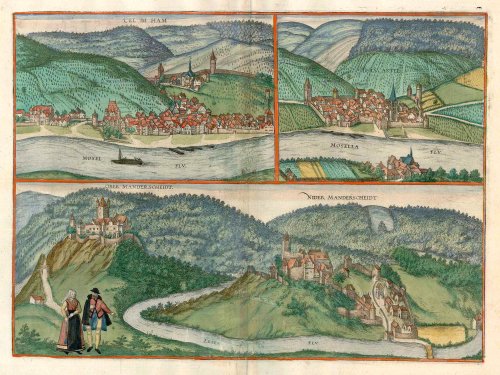
ZELL AN DER MOSEL
Zell, granted its charter in 1222, is seen from an elevated viewpoint on the opposite bank of the Moselle. Zell is the main town in the Zeller Hamm district, the particularly winding section of the Moselle between Pünderich and Alf. Beside the river on the left is the former electoral palace, built from 1530 as a secondary residence for the Trier Electors. Above the town lies the parish church of SS Peter and Paul, whose origins go back to the 12th century. The building on the far right may be the old town hall.
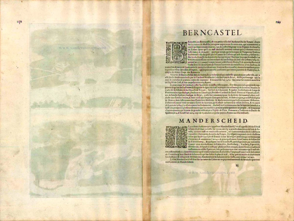
BERNKASTEL
COMMENTARY BY BRAUN (on verso): "Bernkastel is a small town in the archbishopric of Trier, situated on the Moselle. Around 1277 Henry II and subsequently Boemund, both bishops in Trier, furnished the town with a palace with walls, towers, bulwarks and the like. Bishop Boemund also granted the city great privileges and freedoms, such as the status of an imperial city. Opposite Bernkastel lies a magnificent hospice built from the ground up by the highly learned Nicholas of Cusa."
Bernkastel is also seen from a hill on the left bank of the Moselle. Above the town on the right is a glimpse of Landshut castle, a former summer residence of the Trier archbishops, almost entirely destroyed by fire in the 17th century. Braun mentions the Hospital of St Nicholas in Kues on this side of the Moselle, consisting of cloisters and a courtyard founded by Cardinal Nicholas of Cusa. The angle from which Bernkastel is presented here does not permit a view of its picturesque marketplace lined with half-timbered houses from the late Middle Ages and the early Renaissance. In Braun and Hogenberg's day, the St Michael's fountain in the marketplace had only recently been completed, as had the Renaissance town hall. The parish church of St Michael, whose spire doubled as a defensive tower, can be seen in the foreground.
MANDERSCHEID
COMMENTARY BY BRAUN (on verso): "There are two castles here, the Ober and the Unter Manderscheid. Obermanderscheid lies on top of a bluff in the Eifel and, due to its situation, has a great deal of wood and wine available. Untermanderscheid lies in the Eifel on the Lieser river, in an equally fertile location belonging to the Counts of Manderscheid."
Manderscheid's two castles lie in a picturesque landscape. On the left is the Oberburg from the 10th century with its Romanesque keep. When the Oberburg passed into the possession of the archbishops of Trier in the 12th century, the Lords of Manderscheid built the Niederburg as their residence. The town that sprang up around it, also called Niederburg or (as here) Niedermanderscheid, sits 90m above the Lieser and was incorporated within the Niederburg's fortifications in the 14th century by William V of Manderscheid. In 1460 the Lords of Manderscheid were elevated to the rank of Imperial Counts by the Emperor and maintained their status until the French Revolution. (Taschen)
Braun G. & Hogenberg F. and the Civitates Orbis Terrarum.
The Civitates Orbis Terrarum, also known as the 'Braun & Hogenberg', is a six-volume town atlas and the most excellent book of town views and plans ever published: 363 engravings, sometimes beautifully coloured. It was one of the best-selling works in the last quarter of the 16th century. Georg Braun, a skilled writer, wrote the text accompanying the plans and views on the verso. Many plates were engraved after the original drawings of a professional artist, Joris Hoefnagel (1542-1600). The first volume was published in Latin in 1572 and the sixth in 1617. Frans Hogenberg, a talented engraver, created the tables for volumes I through IV, and Simon van den Neuwel made those for volumes V and VI. Other contributors were cartographers Daniel Freese and Heinrich Rantzau, who provided valuable geographical information. Works by Jacob van Deventer, Sebastian Münster, and Johannes Stumpf were also used as references. Translations appeared in German and French, making the atlas accessible to a broader audience.
Since its original publication of volume 1 in 1572, the Civitates Orbis Terrarum has left an indelible mark on the history of cartography. Seven more editions followed the first volume in 1575, 1577, 1582, 1588, 1593, 1599, and 1612. Vol.2, initially released in 1575, saw subsequent editions in 1597 and 1612. The subsequent volumes, each a treasure trove of historical insights, graced the world in 1581, 1588, 1593, 1599, and 1606. The German translation of the first volume, a testament to its widespread appeal, debuted in 1574, followed by the French edition in 1575.
Several printers were involved: Theodor Graminaeus, Heinrich von Aich, Gottfried von Kempen, Johannis Sinniger, Bertram Buchholtz, and Peter von Brachel, all of whom worked in Cologne.
Georg Braun (1541-1622)
Georg Braun, the author of the text accompanying the plans and views in the Civitates Orbis Terrarum, was born in Cologne in 1541. After his studies in Cologne, he entered the Jesuit Order as a novice, indicating his commitment to learning and intellectual pursuits. In 1561, he obtained his bachelor's degree; in 1562, he received his Magister Artium, further demonstrating his academic achievements. Although he left the Jesuit Order, he continued his studies in theology, gaining a licentiate in theology. His theological background likely influenced the content and tone of the text in the Civitates Orbis Terrarum, adding a unique perspective to the work.
Frans Hogenberg (1535-1590)
Frans Hogenberg was a Flemish and German painter, engraver, and mapmaker. He was born in Mechelen as the son of Nicolaas Hogenberg.
By the end of the 1560s, Frans Hogenberg was employed upon Abraham Ortelius's Theatrum Orbis Terrarum, published in 1570; he is named an engraver of numerous maps. In 1568, he was banned from Antwerp by the Duke of Alva and travelled to London, where he stayed a few years before emigrating to Cologne. He immediately embarked on his two most important works, the Civitates, published in 1572 and the Geschichtsblätter, which appeared in several series from 1569 until about 1587.
Thanks to large-scale projects like the Geschichtsblätter and the Civitates, Hogenberg's social circumstances improved with each passing year. He died as a wealthy man in Cologne in 1590.
Cel im Ham [on sheet with] Berncastel [and] Ober Manderscheidt. Nider Manderscheidt
Item Number: 16729 Authenticity Guarantee
Category: Antique maps > Europe > Germany - Cities
Old, antique bird’s-eye view plan of Zell, Berncastel, and Manderscheid, by Georg Braun and Frans Hogenberg.
Title: Cel im Ham [on sheet with] Berncastel [and] Ober Manderscheidt. Nider Manderscheidt
Date of the first edition: 1596.
Date of this map: c. 1610.
Copper engraving, printed on paper.
Size (not including margins): 320 x 440mm (12.6 x 17.32 inches).
Verso: French text.
Condition: Original coloured, excellent.
Condition Rating: A+.
From: Théâtre des Principales Villes de tout l'Univers. Tome 5. c. 1610.
ZELL AN DER MOSEL
Zell, granted its charter in 1222, is seen from an elevated viewpoint on the opposite bank of the Moselle. Zell is the main town in the Zeller Hamm district, the particularly winding section of the Moselle between Pünderich and Alf. Beside the river on the left is the former electoral palace, built from 1530 as a secondary residence for the Trier Electors. Above the town lies the parish church of SS Peter and Paul, whose origins go back to the 12th century. The building on the far right may be the old town hall.
BERNKASTEL
COMMENTARY BY BRAUN (on verso): "Bernkastel is a small town in the archbishopric of Trier, situated on the Moselle. Around 1277 Henry II and subsequently Boemund, both bishops in Trier, furnished the town with a palace with walls, towers, bulwarks and the like. Bishop Boemund also granted the city great privileges and freedoms, such as the status of an imperial city. Opposite Bernkastel lies a magnificent hospice built from the ground up by the highly learned Nicholas of Cusa."
Bernkastel is also seen from a hill on the left bank of the Moselle. Above the town on the right is a glimpse of Landshut castle, a former summer residence of the Trier archbishops, almost entirely destroyed by fire in the 17th century. Braun mentions the Hospital of St Nicholas in Kues on this side of the Moselle, consisting of cloisters and a courtyard founded by Cardinal Nicholas of Cusa. The angle from which Bernkastel is presented here does not permit a view of its picturesque marketplace lined with half-timbered houses from the late Middle Ages and the early Renaissance. In Braun and Hogenberg's day, the St Michael's fountain in the marketplace had only recently been completed, as had the Renaissance town hall. The parish church of St Michael, whose spire doubled as a defensive tower, can be seen in the foreground.
MANDERSCHEID
COMMENTARY BY BRAUN (on verso): "There are two castles here, the Ober and the Unter Manderscheid. Obermanderscheid lies on top of a bluff in the Eifel and, due to its situation, has a great deal of wood and wine available. Untermanderscheid lies in the Eifel on the Lieser river, in an equally fertile location belonging to the Counts of Manderscheid."
Manderscheid's two castles lie in a picturesque landscape. On the left is the Oberburg from the 10th century with its Romanesque keep. When the Oberburg passed into the possession of the archbishops of Trier in the 12th century, the Lords of Manderscheid built the Niederburg as their residence. The town that sprang up around it, also called Niederburg or (as here) Niedermanderscheid, sits 90m above the Lieser and was incorporated within the Niederburg's fortifications in the 14th century by William V of Manderscheid. In 1460 the Lords of Manderscheid were elevated to the rank of Imperial Counts by the Emperor and maintained their status until the French Revolution. (Taschen)
Braun G. & Hogenberg F. and the Civitates Orbis Terrarum.
The Civitates Orbis Terrarum, also known as the 'Braun & Hogenberg', is a six-volume town atlas and the most excellent book of town views and plans ever published: 363 engravings, sometimes beautifully coloured. It was one of the best-selling works in the last quarter of the 16th century. Georg Braun, a skilled writer, wrote the text accompanying the plans and views on the verso. Many plates were engraved after the original drawings of a professional artist, Joris Hoefnagel (1542-1600). The first volume was published in Latin in 1572 and the sixth in 1617. Frans Hogenberg, a talented engraver, created the tables for volumes I through IV, and Simon van den Neuwel made those for volumes V and VI. Other contributors were cartographers Daniel Freese and Heinrich Rantzau, who provided valuable geographical information. Works by Jacob van Deventer, Sebastian Münster, and Johannes Stumpf were also used as references. Translations appeared in German and French, making the atlas accessible to a broader audience.
Since its original publication of volume 1 in 1572, the Civitates Orbis Terrarum has left an indelible mark on the history of cartography. Seven more editions followed the first volume in 1575, 1577, 1582, 1588, 1593, 1599, and 1612. Vol.2, initially released in 1575, saw subsequent editions in 1597 and 1612. The subsequent volumes, each a treasure trove of historical insights, graced the world in 1581, 1588, 1593, 1599, and 1606. The German translation of the first volume, a testament to its widespread appeal, debuted in 1574, followed by the French edition in 1575.
Several printers were involved: Theodor Graminaeus, Heinrich von Aich, Gottfried von Kempen, Johannis Sinniger, Bertram Buchholtz, and Peter von Brachel, all of whom worked in Cologne.
Georg Braun (1541-1622)
Georg Braun, the author of the text accompanying the plans and views in the Civitates Orbis Terrarum, was born in Cologne in 1541. After his studies in Cologne, he entered the Jesuit Order as a novice, indicating his commitment to learning and intellectual pursuits. In 1561, he obtained his bachelor's degree; in 1562, he received his Magister Artium, further demonstrating his academic achievements. Although he left the Jesuit Order, he continued his studies in theology, gaining a licentiate in theology. His theological background likely influenced the content and tone of the text in the Civitates Orbis Terrarum, adding a unique perspective to the work.
Frans Hogenberg (1535-1590)
Frans Hogenberg was a Flemish and German painter, engraver, and mapmaker. He was born in Mechelen as the son of Nicolaas Hogenberg.
By the end of the 1560s, Frans Hogenberg was employed upon Abraham Ortelius's Theatrum Orbis Terrarum, published in 1570; he is named an engraver of numerous maps. In 1568, he was banned from Antwerp by the Duke of Alva and travelled to London, where he stayed a few years before emigrating to Cologne. He immediately embarked on his two most important works, the Civitates, published in 1572 and the Geschichtsblätter, which appeared in several series from 1569 until about 1587.
Thanks to large-scale projects like the Geschichtsblätter and the Civitates, Hogenberg's social circumstances improved with each passing year. He died as a wealthy man in Cologne in 1590.