Weimar, Jena, Erfurt, Gotha, and Fulda, by Georg Braun and Frans Hogenberg. 1574
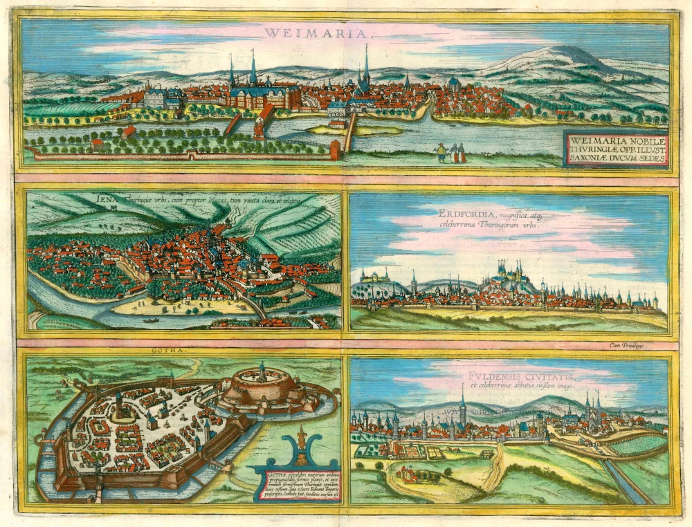
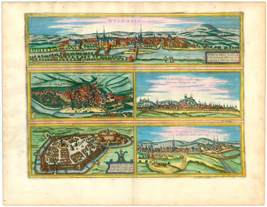
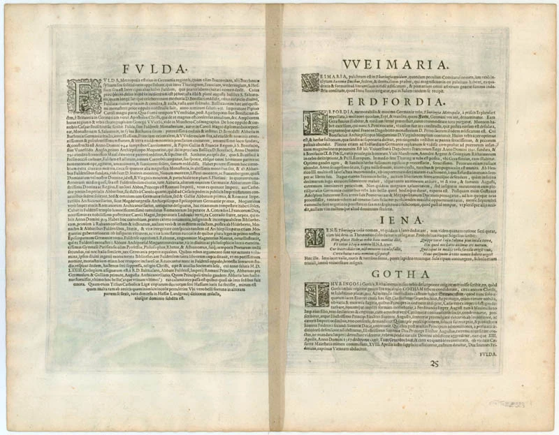


WEIMAR
TRANSLATION OF CARTOUCHE TEXT: Weimar, a handsome town in Thuringia, is the famous seat of the Dukes of Saxony.
COMMENTARY BY BRAUN: " Weimar is an interesting city in Thuringia, which was formerly a county but now serves as the residence of the Duke of Saxony. There is a palace here, beautifully built out of ashlars and worth seeing. There is also a promenade garden, skilfully laid out with all sorts of trees, through which flows the Ilm, which shortly afterwards converges with the Saale."
JENA
TRANSLATION OF CAPTION: Jena, the city in Thuringia, is known and famed for its Muses and, in particular, its vineyards.
COMMENTARY BY BRAUN: "Jena is a city in Thuringia, but I do not see how this name can be derived from Janus since this god was not even worshipped in Germany. Jena is situated in a valley; well fortified with walls and towers; it has a bridge over the Saale, is surrounded by pleasant hills and vineyards, and has an elementary school."
The cityscape is characterised by densely crowded houses, monasteries and, above all, by the parish church of St Michael, rising above its surroundings with its distinctive spire. First mentioned in records in 1182, Jena received its charter in 1230. After belonging to the Lobdeburgs, in 1331, it passed into the possession of the Wettin family; from 1423, it formed part of the Electorate of Saxony. During the Peasants' was of 1524, the Carmelite convent and the Diminician monastery were destroyed. The university was founded in 1558 by Duke John Frederick II of Saxony. The printing industry, flourishing in Jena since the start of the 16th century, rapidly gained importance as the university expanded.
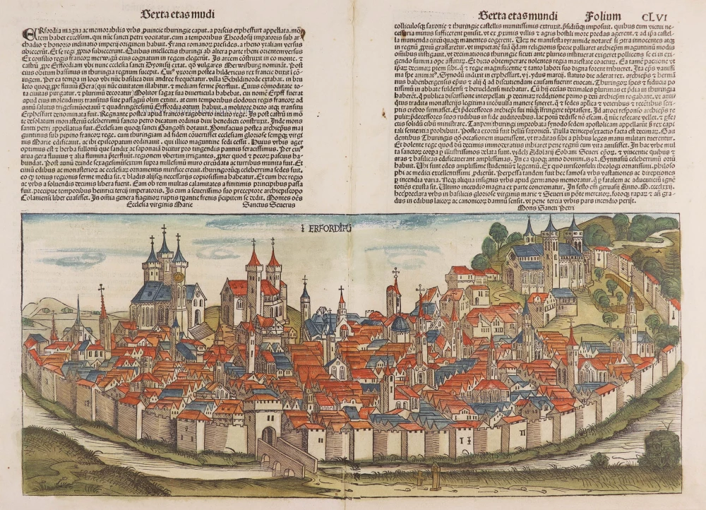
ERFURT
CAPTION: Erfurt, a magnificent and famous city in Thuringia.
COMMENTARY BY BRAUN: "Erfurt is a capital in Thuringia; in the city, there is a high hill that is today called St Peter's Mount, on which there formerly stood a castle, which was destroyed, however, and when Dagobert was the ruler of the Franks a monastery in honour of St Peter was built here. Boniface, the archbishop of Mainz, built the church of Our Lady beside it. The land around Erfurt is fertile beyond bounds; there is also a university founded in 1392 and granted numerous privileges by Boniface IX and Pius II."
The viewer looks at the city, with the Petersberg (St Peter's Mount) at its centre, from a distance. The monastery with the Romanesque church of SS Peter and Paul was built in the 12th century and temporarily accommodated Emperor and kings during the Imperial Diet in Erfurt. The city's most distinctive landmark is the architectural ensemble of the Gothic cathedral (St. Marien) and the Gothic Severikirche, visible on the left behind St Peter's church. On another hill on the far left, at an elevation of 265 m, lies Cyriaksburg: commenced in 1480 and thus seen here in an early form, the castle was later extensively remodelled. Erfurt was founded in AD 742 by Boniface and soon incorporated within the seat of Mainz. In 1392 it saw the inauguration of Germany's third-oldest university, whose most famous student would be Martin Luther, who arrived here in 1501.
GOTHA
CARTOUCHE: Gotha, the best-fortified town in Thuringia, with its famous ring wall, level squares and a castle. The fortress was razed to the ground because it served as a hideout for those outlawed by the Holy Roman Empire.
COMMENTARY BY BRAUN: "Emperor Ferdinand I and his son Maximilian II outlawed Wilhelm Grumbach with all his allies due to his many wrong-doings [...] through which he wanted to overthrow the Emperor and set up a new ruler. [...]"
The view shows the small town heavily fortified with embankments, moats and bastions, with the raised, circular complex of Grimmenstein castle on the right, which stood on the site now occupied by the Baroque Friedenstein palace. The castle was built in the 11th century but was razed in 1567 after the Grumbach Feud. Gotha was granted its municipal charter in the middle of the 12th century and gained importance early on as the Landgraves of Thuringia's residence and trade centre. In the 17th century, Gotha became the seat of the Protestant Dukes of Saxe-Gotha and, consequently, a centre of the natural sciences, arts and the Enlightenment.
FULDA
CAPTION: Picture of the city of Fulda and its famous abbey.
COMMENTARY BY BRAUN: "Fulda lies between Thuringa, Franconia, Wetterau and Hesse. The Fulda flows past this city and has given it its name. There is an admirable old cathedral here, a particular jewel of the whole land [...] and built in AD 755, in the time of St Boniface and King Pippin. Others say Boniface and Charlemagne built it as a monastery and grew into a town."
The engraving shows the town from a side view. Inside the city walls on the right is the large monastery complex founded in 744 on Boniface's initiative and represents the town's germ cell. The Ratgar basilica, which houses the tomb of St Boniface, was built from 791 to 819 and is easily recognizable because of its extravagant design with two towers. In the mid-12th century, Fulda experienced an upswing under Abbot Marward I, who had citadels and fortifications constructed. In 1208 it became a town and from then on enjoyed its right, independent of the Church, which regularly led to conflicts. Frederick II elevated the abbots of the monastery to the rank of princes of the empire. Prince-Abbot Heinrich von Weilnau had a fortified abbot's palace built from 1294 to 1312: it is visible to the right of the central city gate, on the edge of the monastery precinct. (Taschen)
Braun G. & Hogenberg F. and the Civitates Orbis Terrarum.
The Civitates Orbis Terrarum, also known as the 'Braun & Hogenberg', is a six-volume town atlas and the most excellent book of town views and plans ever published: 363 engravings, sometimes beautifully coloured. It was one of the best-selling works in the last quarter of the 16th century. Georg Braun, a skilled writer, wrote the text accompanying the plans and views on the verso. Many plates were engraved after the original drawings of a professional artist, Joris Hoefnagel (1542-1600). The first volume was published in Latin in 1572 and the sixth in 1617. Frans Hogenberg, a talented engraver, created the tables for volumes I through IV, and Simon van den Neuwel made those for volumes V and VI. Other contributors were cartographers Daniel Freese and Heinrich Rantzau, who provided valuable geographical information. Works by Jacob van Deventer, Sebastian Münster, and Johannes Stumpf were also used as references. Translations appeared in German and French, making the atlas accessible to a wider audience.
Since its original publication of volume 1 in 1572, the Civitates Orbis Terrarum has left an indelible mark on the history of cartography. The first volume was followed by seven more editions in 1575, 1577, 1582, 1588, 1593, 1599, and 1612. Vol.2, initially released in 1575, saw subsequent editions in 1597 and 1612. The subsequent volumes, each a treasure trove of historical insights, graced the world in 1581, 1588, 1593, 1599, and 1606. The German translation of the first volume, a testament to its widespread appeal, debuted in 1574, followed by the French edition in 1575.
Several printers were involved: Theodor Graminaeus, Heinrich von Aich, Gottfried von Kempen, Johannis Sinniger, Bertram Buchholtz, and Peter von Brachel, all of whom worked in Cologne.
Georg Braun (1541-1622)
Georg Braun, the author of the text accompanying the plans and views in the Civitates Orbis Terrarum, was born in Cologne in 1541. After his studies in Cologne, he entered the Jesuit Order as a novice, indicating his commitment to learning and intellectual pursuits. In 1561, he obtained his bachelor's degree; in 1562, he received his Magister Artium, further demonstrating his academic achievements. Although he left the Jesuit Order, he continued his studies in theology, gaining a licentiate in theology. His theological background likely influenced the content and tone of the text in the Civitates Orbis Terrarum, adding a unique perspective to the work.
Frans Hogenberg (1535-1590)
Frans Hogenberg was a Flemish and German painter, engraver, and mapmaker. He was born in Mechelen as the son of Nicolaas Hogenberg.
By the end of the 1560s, Frans Hogenberg was employed upon Abraham Ortelius's Theatrum Orbis Terrarum, published in 1570; he is named an engraver of numerous maps. In 1568, he was banned from Antwerp by the Duke of Alva and travelled to London, where he stayed a few years before emigrating to Cologne. He immediately embarked on his two most important works, the Civitates, published in 1572 and the Geschichtsblätter, which appeared in several series from 1569 until about 1587.
Thanks to large-scale projects like the Geschichtsblätter and the Civitates, Hogenberg's social circumstances improved with each passing year. He died as a wealthy man in Cologne in 1590.
Weimaria [on sheet with] Iena [and] Erdfordia [and] Gotha [and] Fuldensis Civitatis.
Item Number: 22323 Authenticity Guarantee
Category: Antique maps > Europe > Germany - Cities
Five bird's-eye views by Braun & Hogenberg on one sheet: Weimar, Jena, Erfurt, Gotha, and Fulda, by Georg Braun and Frans Hogenberg.
Title: Weimaria [on sheet with] Iena [and] Erdfordia [and] Gotha [and] Fuldensis Civitatis.
Date: 1574.
Copper engraving, printed on paper.
Size (not including margins): 345 x 455mm (13.58 x 17.91 inches).
Verso: German text.
Condition: Superb old colour, excellent.
Condition Rating: A+.
From: Beschreibung und Contrafactur der Vornembster Stät der Welt. Liber Primus. Köln, 1574. (Van der Krogt 4, 41:2.1)
WEIMAR
TRANSLATION OF CARTOUCHE TEXT: Weimar, a handsome town in Thuringia, is the famous seat of the Dukes of Saxony.
COMMENTARY BY BRAUN: " Weimar is an interesting city in Thuringia, which was formerly a county but now serves as the residence of the Duke of Saxony. There is a palace here, beautifully built out of ashlars and worth seeing. There is also a promenade garden, skilfully laid out with all sorts of trees, through which flows the Ilm, which shortly afterwards converges with the Saale."
JENA
TRANSLATION OF CAPTION: Jena, the city in Thuringia, is known and famed for its Muses and, in particular, its vineyards.
COMMENTARY BY BRAUN: "Jena is a city in Thuringia, but I do not see how this name can be derived from Janus since this god was not even worshipped in Germany. Jena is situated in a valley; well fortified with walls and towers; it has a bridge over the Saale, is surrounded by pleasant hills and vineyards, and has an elementary school."
The cityscape is characterised by densely crowded houses, monasteries and, above all, by the parish church of St Michael, rising above its surroundings with its distinctive spire. First mentioned in records in 1182, Jena received its charter in 1230. After belonging to the Lobdeburgs, in 1331, it passed into the possession of the Wettin family; from 1423, it formed part of the Electorate of Saxony. During the Peasants' was of 1524, the Carmelite convent and the Diminician monastery were destroyed. The university was founded in 1558 by Duke John Frederick II of Saxony. The printing industry, flourishing in Jena since the start of the 16th century, rapidly gained importance as the university expanded.
ERFURT
CAPTION: Erfurt, a magnificent and famous city in Thuringia.
COMMENTARY BY BRAUN: "Erfurt is a capital in Thuringia; in the city, there is a high hill that is today called St Peter's Mount, on which there formerly stood a castle, which was destroyed, however, and when Dagobert was the ruler of the Franks a monastery in honour of St Peter was built here. Boniface, the archbishop of Mainz, built the church of Our Lady beside it. The land around Erfurt is fertile beyond bounds; there is also a university founded in 1392 and granted numerous privileges by Boniface IX and Pius II."
The viewer looks at the city, with the Petersberg (St Peter's Mount) at its centre, from a distance. The monastery with the Romanesque church of SS Peter and Paul was built in the 12th century and temporarily accommodated Emperor and kings during the Imperial Diet in Erfurt. The city's most distinctive landmark is the architectural ensemble of the Gothic cathedral (St. Marien) and the Gothic Severikirche, visible on the left behind St Peter's church. On another hill on the far left, at an elevation of 265 m, lies Cyriaksburg: commenced in 1480 and thus seen here in an early form, the castle was later extensively remodelled. Erfurt was founded in AD 742 by Boniface and soon incorporated within the seat of Mainz. In 1392 it saw the inauguration of Germany's third-oldest university, whose most famous student would be Martin Luther, who arrived here in 1501.
GOTHA
CARTOUCHE: Gotha, the best-fortified town in Thuringia, with its famous ring wall, level squares and a castle. The fortress was razed to the ground because it served as a hideout for those outlawed by the Holy Roman Empire.
COMMENTARY BY BRAUN: "Emperor Ferdinand I and his son Maximilian II outlawed Wilhelm Grumbach with all his allies due to his many wrong-doings [...] through which he wanted to overthrow the Emperor and set up a new ruler. [...]"
The view shows the small town heavily fortified with embankments, moats and bastions, with the raised, circular complex of Grimmenstein castle on the right, which stood on the site now occupied by the Baroque Friedenstein palace. The castle was built in the 11th century but was razed in 1567 after the Grumbach Feud. Gotha was granted its municipal charter in the middle of the 12th century and gained importance early on as the Landgraves of Thuringia's residence and trade centre. In the 17th century, Gotha became the seat of the Protestant Dukes of Saxe-Gotha and, consequently, a centre of the natural sciences, arts and the Enlightenment.
FULDA
CAPTION: Picture of the city of Fulda and its famous abbey.
COMMENTARY BY BRAUN: "Fulda lies between Thuringa, Franconia, Wetterau and Hesse. The Fulda flows past this city and has given it its name. There is an admirable old cathedral here, a particular jewel of the whole land [...] and built in AD 755, in the time of St Boniface and King Pippin. Others say Boniface and Charlemagne built it as a monastery and grew into a town."
The engraving shows the town from a side view. Inside the city walls on the right is the large monastery complex founded in 744 on Boniface's initiative and represents the town's germ cell. The Ratgar basilica, which houses the tomb of St Boniface, was built from 791 to 819 and is easily recognizable because of its extravagant design with two towers. In the mid-12th century, Fulda experienced an upswing under Abbot Marward I, who had citadels and fortifications constructed. In 1208 it became a town and from then on enjoyed its right, independent of the Church, which regularly led to conflicts. Frederick II elevated the abbots of the monastery to the rank of princes of the empire. Prince-Abbot Heinrich von Weilnau had a fortified abbot's palace built from 1294 to 1312: it is visible to the right of the central city gate, on the edge of the monastery precinct. (Taschen)
Braun G. & Hogenberg F. and the Civitates Orbis Terrarum.
The Civitates Orbis Terrarum, also known as the 'Braun & Hogenberg', is a six-volume town atlas and the most excellent book of town views and plans ever published: 363 engravings, sometimes beautifully coloured. It was one of the best-selling works in the last quarter of the 16th century. Georg Braun, a skilled writer, wrote the text accompanying the plans and views on the verso. Many plates were engraved after the original drawings of a professional artist, Joris Hoefnagel (1542-1600). The first volume was published in Latin in 1572 and the sixth in 1617. Frans Hogenberg, a talented engraver, created the tables for volumes I through IV, and Simon van den Neuwel made those for volumes V and VI. Other contributors were cartographers Daniel Freese and Heinrich Rantzau, who provided valuable geographical information. Works by Jacob van Deventer, Sebastian Münster, and Johannes Stumpf were also used as references. Translations appeared in German and French, making the atlas accessible to a wider audience.
Since its original publication of volume 1 in 1572, the Civitates Orbis Terrarum has left an indelible mark on the history of cartography. The first volume was followed by seven more editions in 1575, 1577, 1582, 1588, 1593, 1599, and 1612. Vol.2, initially released in 1575, saw subsequent editions in 1597 and 1612. The subsequent volumes, each a treasure trove of historical insights, graced the world in 1581, 1588, 1593, 1599, and 1606. The German translation of the first volume, a testament to its widespread appeal, debuted in 1574, followed by the French edition in 1575.
Several printers were involved: Theodor Graminaeus, Heinrich von Aich, Gottfried von Kempen, Johannis Sinniger, Bertram Buchholtz, and Peter von Brachel, all of whom worked in Cologne.
Georg Braun (1541-1622)
Georg Braun, the author of the text accompanying the plans and views in the Civitates Orbis Terrarum, was born in Cologne in 1541. After his studies in Cologne, he entered the Jesuit Order as a novice, indicating his commitment to learning and intellectual pursuits. In 1561, he obtained his bachelor's degree; in 1562, he received his Magister Artium, further demonstrating his academic achievements. Although he left the Jesuit Order, he continued his studies in theology, gaining a licentiate in theology. His theological background likely influenced the content and tone of the text in the Civitates Orbis Terrarum, adding a unique perspective to the work.
Frans Hogenberg (1535-1590)
Frans Hogenberg was a Flemish and German painter, engraver, and mapmaker. He was born in Mechelen as the son of Nicolaas Hogenberg.
By the end of the 1560s, Frans Hogenberg was employed upon Abraham Ortelius's Theatrum Orbis Terrarum, published in 1570; he is named an engraver of numerous maps. In 1568, he was banned from Antwerp by the Duke of Alva and travelled to London, where he stayed a few years before emigrating to Cologne. He immediately embarked on his two most important works, the Civitates, published in 1572 and the Geschichtsblätter, which appeared in several series from 1569 until about 1587.
Thanks to large-scale projects like the Geschichtsblätter and the Civitates, Hogenberg's social circumstances improved with each passing year. He died as a wealthy man in Cologne in 1590.