Arnsberg by Georg Braun and Frans Hogenberg. c. 1593
The item displayed on this page has been sold. However, we have a similar map in stock:
Arnsberg by Georg Braun and Frans Hogenberg. 1588
Arnsberg.
[Item number: 32198]


COMMENTARY BY BRAUN: "The fair and noble land of Westphalia between the Weser and the Rhine stretches to the land of Hesse and in the north as far as Friesland. It is divided into many different counties, duchies and noble estates. [...] One of these is the County of Arnsberg, not the least in renown and merit, whose lords and counts, especially Frederick, [...] also called themselves Counts of Westphalia."
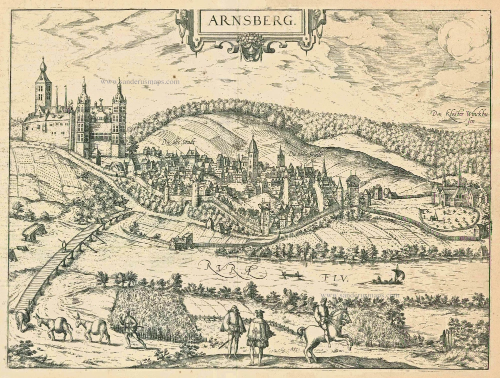
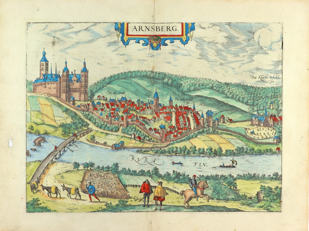
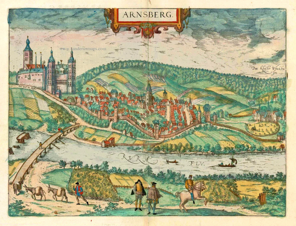
In this view of the city, which is laid out in elliptical form on the narrow ridge of a hill in the Rhenish Uplands within a narrow loop of the Ruhr, the dominating feature is the castle, built in the 11th century by the Counts of Arnsberg, and considerably expanded in the 14th century by the Electors of Cologne. The city was fortified with walls and towers. At the southern end of it was the monastery of Winckhusen, dating from the 15th century, which later became the abbey of Wedinghausen. In 1600, the city was destroyed by fire, but by 1632, it already had 227 households again. The castle was destroyed in 1762 by the Prince of Brunswick during the Seven Years' War. The plate emphasises the city's key position on various essential routes: the main road from Soest leads over a guarded bridge to the city, and the Ruhr, which flows past the city, is navigable for merchant ships. The figures in the foreground illustrate the city's position of power: nobleman, knight and guard. (Taschen)
Braun G. & Hogenberg F. and the Civitates Orbis Terrarum.
The Civitates Orbis Terrarum, also known as the 'Braun & Hogenberg', is a six-volume town atlas and the most excellent book of town views and plans ever published: 363 engravings, sometimes beautifully coloured. It was one of the best-selling works in the last quarter of the 16th century. Georg Braun, a skilled writer, wrote the text accompanying the plans and views on the verso. Many plates were engraved after the original drawings of a professional artist, Joris Hoefnagel (1542-1600). The first volume was published in Latin in 1572 and the sixth in 1617. Frans Hogenberg, a talented engraver, created the tables for volumes I through IV, and Simon van den Neuwel made those for volumes V and VI. Other contributors were cartographers Daniel Freese and Heinrich Rantzau, who provided valuable geographical information. Works by Jacob van Deventer, Sebastian Münster, and Johannes Stumpf were also used as references. Translations appeared in German and French, making the atlas accessible to a broader audience.
Since its original publication of volume 1 in 1572, the Civitates Orbis Terrarum has left an indelible mark on the history of cartography. Seven more editions followed the first volume in 1575, 1577, 1582, 1588, 1593, 1599, and 1612. Vol.2, initially released in 1575, saw subsequent editions in 1597 and 1612. The subsequent volumes, each a treasure trove of historical insights, graced the world in 1581, 1588, 1593, 1599, and 1606. The German translation of the first volume, a testament to its widespread appeal, debuted in 1574, followed by the French edition in 1575.
Several printers were involved: Theodor Graminaeus, Heinrich von Aich, Gottfried von Kempen, Johannis Sinniger, Bertram Buchholtz, and Peter von Brachel, all of whom worked in Cologne.
Georg Braun (1541-1622)
Georg Braun, the author of the text accompanying the plans and views in the Civitates Orbis Terrarum, was born in Cologne in 1541. After his studies in Cologne, he entered the Jesuit Order as a novice, indicating his commitment to learning and intellectual pursuits. In 1561, he obtained his bachelor's degree; in 1562, he received his Magister Artium, further demonstrating his academic achievements. Although he left the Jesuit Order, he continued his studies in theology, gaining a licentiate in theology. His theological background likely influenced the content and tone of the text in the Civitates Orbis Terrarum, adding a unique perspective to the work.
Frans Hogenberg (1535-1590)
Frans Hogenberg was a Flemish and German painter, engraver, and mapmaker. He was born in Mechelen as the son of Nicolaas Hogenberg.
By the end of the 1560s, Frans Hogenberg was employed upon Abraham Ortelius's Theatrum Orbis Terrarum, published in 1570; he is named an engraver of numerous maps. In 1568, he was banned from Antwerp by the Duke of Alva and travelled to London, where he stayed a few years before emigrating to Cologne. He immediately embarked on his two most important works, the Civitates, published in 1572 and the Geschichtsblätter, which appeared in several series from 1569 until about 1587.
Thanks to large-scale projects like the Geschichtsblätter and the Civitates, Hogenberg's social circumstances improved with each passing year. He died as a wealthy man in Cologne in 1590.
Arnsberg.
Item Number: 24566 Authenticity Guarantee
Category: Antique maps > Europe > Germany - Cities
Arnsberg by Georg Braun and Frans Hogenberg.
Title: Arnsberg.
Date of the first edition: 1588.
Date of this map: c. 1593.
Copper engraving, printed on paper.
Image size: 323 x 433mm (12.72 x 17.05 inches).
Sheet size: 410 x 540mm (16.14 x 21.26 inches).
Verso: French text.
Condition: Original coloured, excellent.
Condition Rating: A+.
From: Liber Quartus - Livre Quatriesme des Principales Villes du Monde, 1593. (Van der Krogt 4, 41:3.4(1593))
COMMENTARY BY BRAUN: "The fair and noble land of Westphalia between the Weser and the Rhine stretches to the land of Hesse and in the north as far as Friesland. It is divided into many different counties, duchies and noble estates. [...] One of these is the County of Arnsberg, not the least in renown and merit, whose lords and counts, especially Frederick, [...] also called themselves Counts of Westphalia."
In this view of the city, which is laid out in elliptical form on the narrow ridge of a hill in the Rhenish Uplands within a narrow loop of the Ruhr, the dominating feature is the castle, built in the 11th century by the Counts of Arnsberg, and considerably expanded in the 14th century by the Electors of Cologne. The city was fortified with walls and towers. At the southern end of it was the monastery of Winckhusen, dating from the 15th century, which later became the abbey of Wedinghausen. In 1600, the city was destroyed by fire, but by 1632, it already had 227 households again. The castle was destroyed in 1762 by the Prince of Brunswick during the Seven Years' War. The plate emphasises the city's key position on various essential routes: the main road from Soest leads over a guarded bridge to the city, and the Ruhr, which flows past the city, is navigable for merchant ships. The figures in the foreground illustrate the city's position of power: nobleman, knight and guard. (Taschen)
Braun G. & Hogenberg F. and the Civitates Orbis Terrarum.
The Civitates Orbis Terrarum, also known as the 'Braun & Hogenberg', is a six-volume town atlas and the most excellent book of town views and plans ever published: 363 engravings, sometimes beautifully coloured. It was one of the best-selling works in the last quarter of the 16th century. Georg Braun, a skilled writer, wrote the text accompanying the plans and views on the verso. Many plates were engraved after the original drawings of a professional artist, Joris Hoefnagel (1542-1600). The first volume was published in Latin in 1572 and the sixth in 1617. Frans Hogenberg, a talented engraver, created the tables for volumes I through IV, and Simon van den Neuwel made those for volumes V and VI. Other contributors were cartographers Daniel Freese and Heinrich Rantzau, who provided valuable geographical information. Works by Jacob van Deventer, Sebastian Münster, and Johannes Stumpf were also used as references. Translations appeared in German and French, making the atlas accessible to a broader audience.
Since its original publication of volume 1 in 1572, the Civitates Orbis Terrarum has left an indelible mark on the history of cartography. Seven more editions followed the first volume in 1575, 1577, 1582, 1588, 1593, 1599, and 1612. Vol.2, initially released in 1575, saw subsequent editions in 1597 and 1612. The subsequent volumes, each a treasure trove of historical insights, graced the world in 1581, 1588, 1593, 1599, and 1606. The German translation of the first volume, a testament to its widespread appeal, debuted in 1574, followed by the French edition in 1575.
Several printers were involved: Theodor Graminaeus, Heinrich von Aich, Gottfried von Kempen, Johannis Sinniger, Bertram Buchholtz, and Peter von Brachel, all of whom worked in Cologne.
Georg Braun (1541-1622)
Georg Braun, the author of the text accompanying the plans and views in the Civitates Orbis Terrarum, was born in Cologne in 1541. After his studies in Cologne, he entered the Jesuit Order as a novice, indicating his commitment to learning and intellectual pursuits. In 1561, he obtained his bachelor's degree; in 1562, he received his Magister Artium, further demonstrating his academic achievements. Although he left the Jesuit Order, he continued his studies in theology, gaining a licentiate in theology. His theological background likely influenced the content and tone of the text in the Civitates Orbis Terrarum, adding a unique perspective to the work.
Frans Hogenberg (1535-1590)
Frans Hogenberg was a Flemish and German painter, engraver, and mapmaker. He was born in Mechelen as the son of Nicolaas Hogenberg.
By the end of the 1560s, Frans Hogenberg was employed upon Abraham Ortelius's Theatrum Orbis Terrarum, published in 1570; he is named an engraver of numerous maps. In 1568, he was banned from Antwerp by the Duke of Alva and travelled to London, where he stayed a few years before emigrating to Cologne. He immediately embarked on his two most important works, the Civitates, published in 1572 and the Geschichtsblätter, which appeared in several series from 1569 until about 1587.
Thanks to large-scale projects like the Geschichtsblätter and the Civitates, Hogenberg's social circumstances improved with each passing year. He died as a wealthy man in Cologne in 1590.