
Bardowick by Georg Braun & Frans Hogenberg. 1617
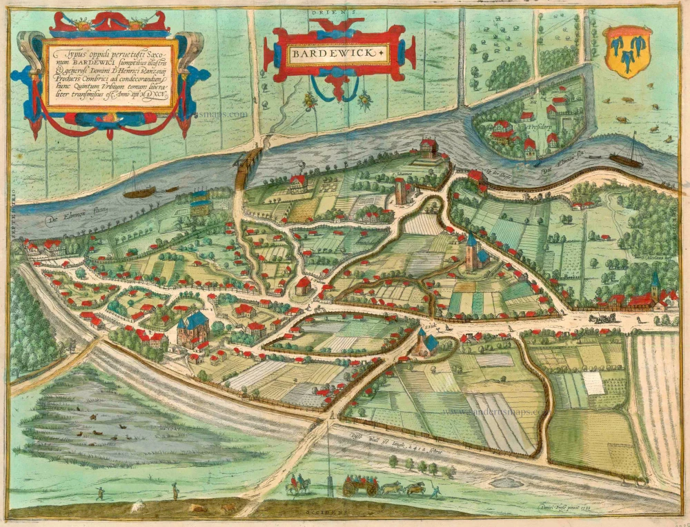


TRANSLATION OF CARTOUCHE TEXT: The picture of the very ancient Saxon town of Bardowick was generously procured by Heinrich Rantzau, lord of the Lower Elbe, to further embellish this fifth volume. In the year 1595.
COMMENTARY BY BRAUN (on verso): "Bardowick was formerly an ancient town in Saxony and was inhabited, as the name suggests, by the Bards or Lombards (who were powerful people, but were nevertheless skilful, robust and valiant and who ruled on the right bank of the Elbe from Magdeburg down to Stade). Towards midnight or the north it lies about two miles from Lüneburg and is built on the River Lunow, which is also called Ilmenau."
Bardowick is presented in a bird's-eye view from the northwest, offering a good view of the collegiate church of SS Peter and Paul with its twin-towered west façade (bottom left). One of the oldest towns in Lower Saxony, Bardowick is first documented in AD 795, although a village by the name of Bardorum is already mentioned in Roman sources from an even earlier date. Thanks to its favourable location at the crossroads of two trade routes, Bardowick rapidly became a major centre of commerce. At that time, moreover, the Ilmenau was navigable only between Bardowick and the Elbe, the latter providing access to the sea. This meant that salt produced in Lüneburg had to be shipped via Bardowick. In 972 Bardowick was granted civic, coignage and toll rights, leading to economic prosperity. The town lost its role as a commercial hub in the mid-12th century, however, as Lübeck rose in importance and the Ilmenau became navigable as far as Lüneburg. (Taschen)
Braun G. & Hogenberg F. and the Civitates Orbis Terrarum.
The Civitates Orbis Terrarum, also known as the 'Braun & Hogenberg', is a six-volume town atlas and the most excellent book of town views and plans ever published: 363 engravings, sometimes beautifully coloured. It was one of the best-selling works in the last quarter of the 16th century. Georg Braun, a skilled writer, wrote the text accompanying the plans and views on the verso. Many plates were engraved after the original drawings of a professional artist, Joris Hoefnagel (1542-1600). The first volume was published in Latin in 1572 and the sixth in 1617. Frans Hogenberg, a talented engraver, created the tables for volumes I through IV, and Simon van den Neuwel made those for volumes V and VI. Other contributors were cartographers Daniel Freese and Heinrich Rantzau, who provided valuable geographical information. Works by Jacob van Deventer, Sebastian Münster, and Johannes Stumpf were also used as references. Translations appeared in German and French, making the atlas accessible to a broader audience.
Since its original publication of volume 1 in 1572, the Civitates Orbis Terrarum has left an indelible mark on the history of cartography. Seven more editions followed the first volume in 1575, 1577, 1582, 1588, 1593, 1599, and 1612. Vol.2, initially released in 1575, saw subsequent editions in 1597 and 1612. The subsequent volumes, each a treasure trove of historical insights, graced the world in 1581, 1588, 1593, 1599, and 1606. The German translation of the first volume, a testament to its widespread appeal, debuted in 1574, followed by the French edition in 1575.
Several printers were involved: Theodor Graminaeus, Heinrich von Aich, Gottfried von Kempen, Johannis Sinniger, Bertram Buchholtz, and Peter von Brachel, all of whom worked in Cologne.
Georg Braun (1541-1622)
Georg Braun, the author of the text accompanying the plans and views in the Civitates Orbis Terrarum, was born in Cologne in 1541. After his studies in Cologne, he entered the Jesuit Order as a novice, indicating his commitment to learning and intellectual pursuits. In 1561, he obtained his bachelor's degree; in 1562, he received his Magister Artium, further demonstrating his academic achievements. Although he left the Jesuit Order, he continued his studies in theology, gaining a licentiate in theology. His theological background likely influenced the content and tone of the text in the Civitates Orbis Terrarum, adding a unique perspective to the work.
Frans Hogenberg (1535-1590)
Frans Hogenberg was a Flemish and German painter, engraver, and mapmaker. He was born in Mechelen as the son of Nicolaas Hogenberg.
By the end of the 1560s, Frans Hogenberg was employed upon Abraham Ortelius's Theatrum Orbis Terrarum, published in 1570; he is named an engraver of numerous maps. In 1568, he was banned from Antwerp by the Duke of Alva and travelled to London, where he stayed a few years before emigrating to Cologne. He immediately embarked on his two most important works, the Civitates, published in 1572 and the Geschichtsblätter, which appeared in several series from 1569 until about 1587.
Thanks to large-scale projects like the Geschichtsblätter and the Civitates, Hogenberg's social circumstances improved with each passing year. He died as a wealthy man in Cologne in 1590.
Bardewick.
Item Number: 23385 Authenticity Guarantee
Category: Antique maps > Europe > Germany - Cities
Old, antique bird’s-eye view plan of Bardowick, by Georg Braun & Frans Hogenberg.
Title: Bardewick
Daniel Frese pinxit 1588.
Oriented to the east.
Cartographer: Daniel Frese.
Date of the first edition: 1596.
Date of this map: 1623.
Date on map: 1588.
Copper engraving, printed on paper.
Size (not including margins): 384 x 512mm (15.12 x 20.16 inches).
Verso: Latin text.
Condition: Excellent, superb old colour.
Condition Rating: A+.
References: Van der Krogt 4, #387, State 1; Fauser, #1083; Taschen, Br. Hog., p.407
From: Urbium Praeipuarum Mundi Theatrum Quintum Auctore Georgio Braunio Agrippinate. Part 5. Köln, Petrus von Brachel, 1623. (Van der Krogt 4, 41:1.5)
TRANSLATION OF CARTOUCHE TEXT: The picture of the very ancient Saxon town of Bardowick was generously procured by Heinrich Rantzau, lord of the Lower Elbe, to further embellish this fifth volume. In the year 1595.
COMMENTARY BY BRAUN (on verso): "Bardowick was formerly an ancient town in Saxony and was inhabited, as the name suggests, by the Bards or Lombards (who were powerful people, but were nevertheless skilful, robust and valiant and who ruled on the right bank of the Elbe from Magdeburg down to Stade). Towards midnight or the north it lies about two miles from Lüneburg and is built on the River Lunow, which is also called Ilmenau."
Bardowick is presented in a bird's-eye view from the northwest, offering a good view of the collegiate church of SS Peter and Paul with its twin-towered west façade (bottom left). One of the oldest towns in Lower Saxony, Bardowick is first documented in AD 795, although a village by the name of Bardorum is already mentioned in Roman sources from an even earlier date. Thanks to its favourable location at the crossroads of two trade routes, Bardowick rapidly became a major centre of commerce. At that time, moreover, the Ilmenau was navigable only between Bardowick and the Elbe, the latter providing access to the sea. This meant that salt produced in Lüneburg had to be shipped via Bardowick. In 972 Bardowick was granted civic, coignage and toll rights, leading to economic prosperity. The town lost its role as a commercial hub in the mid-12th century, however, as Lübeck rose in importance and the Ilmenau became navigable as far as Lüneburg. (Taschen)
Braun G. & Hogenberg F. and the Civitates Orbis Terrarum.
The Civitates Orbis Terrarum, also known as the 'Braun & Hogenberg', is a six-volume town atlas and the most excellent book of town views and plans ever published: 363 engravings, sometimes beautifully coloured. It was one of the best-selling works in the last quarter of the 16th century. Georg Braun, a skilled writer, wrote the text accompanying the plans and views on the verso. Many plates were engraved after the original drawings of a professional artist, Joris Hoefnagel (1542-1600). The first volume was published in Latin in 1572 and the sixth in 1617. Frans Hogenberg, a talented engraver, created the tables for volumes I through IV, and Simon van den Neuwel made those for volumes V and VI. Other contributors were cartographers Daniel Freese and Heinrich Rantzau, who provided valuable geographical information. Works by Jacob van Deventer, Sebastian Münster, and Johannes Stumpf were also used as references. Translations appeared in German and French, making the atlas accessible to a broader audience.
Since its original publication of volume 1 in 1572, the Civitates Orbis Terrarum has left an indelible mark on the history of cartography. Seven more editions followed the first volume in 1575, 1577, 1582, 1588, 1593, 1599, and 1612. Vol.2, initially released in 1575, saw subsequent editions in 1597 and 1612. The subsequent volumes, each a treasure trove of historical insights, graced the world in 1581, 1588, 1593, 1599, and 1606. The German translation of the first volume, a testament to its widespread appeal, debuted in 1574, followed by the French edition in 1575.
Several printers were involved: Theodor Graminaeus, Heinrich von Aich, Gottfried von Kempen, Johannis Sinniger, Bertram Buchholtz, and Peter von Brachel, all of whom worked in Cologne.
Georg Braun (1541-1622)
Georg Braun, the author of the text accompanying the plans and views in the Civitates Orbis Terrarum, was born in Cologne in 1541. After his studies in Cologne, he entered the Jesuit Order as a novice, indicating his commitment to learning and intellectual pursuits. In 1561, he obtained his bachelor's degree; in 1562, he received his Magister Artium, further demonstrating his academic achievements. Although he left the Jesuit Order, he continued his studies in theology, gaining a licentiate in theology. His theological background likely influenced the content and tone of the text in the Civitates Orbis Terrarum, adding a unique perspective to the work.
Frans Hogenberg (1535-1590)
Frans Hogenberg was a Flemish and German painter, engraver, and mapmaker. He was born in Mechelen as the son of Nicolaas Hogenberg.
By the end of the 1560s, Frans Hogenberg was employed upon Abraham Ortelius's Theatrum Orbis Terrarum, published in 1570; he is named an engraver of numerous maps. In 1568, he was banned from Antwerp by the Duke of Alva and travelled to London, where he stayed a few years before emigrating to Cologne. He immediately embarked on his two most important works, the Civitates, published in 1572 and the Geschichtsblätter, which appeared in several series from 1569 until about 1587.
Thanks to large-scale projects like the Geschichtsblätter and the Civitates, Hogenberg's social circumstances improved with each passing year. He died as a wealthy man in Cologne in 1590.