
Eutin - Tønder by Braun & Hogenberg c. 1610

EUTIN
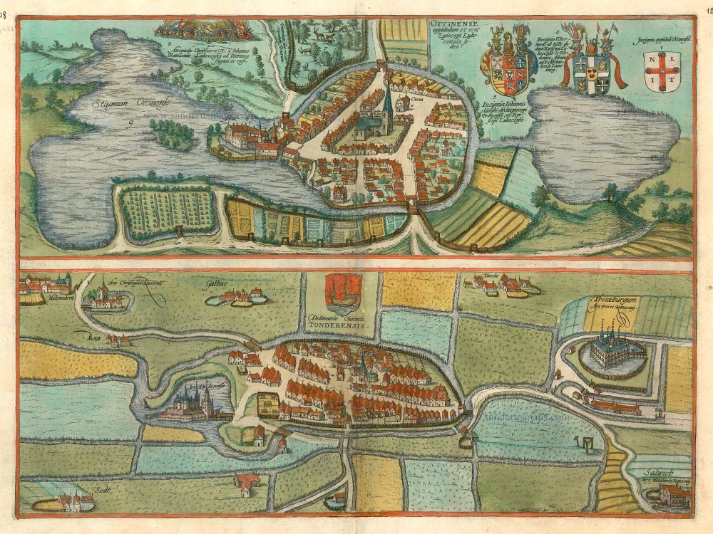
CAPTION: Eutin, a small town with a castle, is the seat of the bishop of Lübeck.
COMMENTARY BY BRAUN (on verso): "The little town with the castle, in which the bishops of Lübeck now normally hold court, was built by Adolph II, Count of Holstein, Wagrien and Schauenburg, by whom the town was also granted its coat of arms and its charter. At the wish of Henry the Lion, around the year 1159, Adolph II made a gift of the castle with 300 morgens of land to the diocese of Oldenburg."
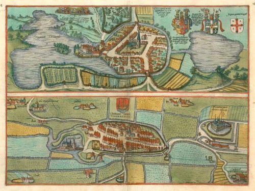
The bird's-eye view from the north illustrates how Eutin, which had no ring wall, drew its protection solely from the two lakes surrounding it, namely the Greater and the Lesser Lake Eutin. The church of St Michaell is at the centre of the town, which is depicted stereotypically. In 1156 Eutin passed to the diocese of Oldenburg and, in 1300, became the episcopal see of the prince-bishops of Lübeck. The bishop's palace lies on a spit of land on the northeast side of the town (4). An episode from the battle over this palace is shown above; after the death of Frederick I of Denmark on 10 April 1533, the Lübeck bishops occupied Holstein; one year later, however, they were driven back by the troops of Christian III under his commander-in-chief Johann Rantzau, the father of Heinrich Rantzau, who was, in turn, one of Georg Braun's sources. From 1586 the Dukes of Schleswig-Holstein-Gottorp supplied the prince-bishops of Lübeck and came into possession of Eutin. As a result, frequent alterations were carried out on the palace, which had to be completely rebuilt after a devastating fire in 1689.
TØNDER
COMMENTARY BY BRAUN (on verso): "Tønder is a delightful little town in the Duchy of Schleswig in a fertile location with both arable land and pastures. Its convenience for shipping is adequately demonstrated by the coat of arms bearing a boat. But, unfortunately, in 1532, a storm caused the water to rise three and a half feet right up to the main church, in memory of which people have now carved crosses everywhere into the walls."
The plate shows a bird's-eye view of Tønder from the east, with the Vida River flowing around it. Documented as a port since 1017, the small town is surrounded by moated castles. On the left lies Tønder castle (Arx Tonderensis), and in the top left-hand corner, the Møgeltøndernhus, documented since 1233, which lies 7 km west of Tønder near the settlement of Møgeltønder and was inhabited by Christoffer Rantzau. North of Tønder lies the magnificent moated castle of Troyburg, the residence of Peter Rantzau, beneath which is Sollwig castle, home to the Danish governor of Holstein-Gottorp, Melchior Rantzau. After the foundation of Dominican and Franciscan monasteries, the town grew and was granted a municipal charter in 1243. As one of the few ports on the west coast of Schleswig, it profited economically from its geographical position, even if this also contained disadvantages: the town was visited frequently by floods. Tønder, which lies 4 km from the border with Germany, formed part of the German Empire until 1920, when it passed to Denmark.
Oitinense oppidulum et arx Episcopi Lubecensis sedes [on sheet with] Delineatio Civitatis Tonderensis
Item Number: 24595 Authenticity Guarantee
Category: Antique maps > Europe > Germany - Cities
Antique map with two bird's-eye plans by Braun and Hogenberg: Tønder (Denmark) and Eutin (Germany).
Title: Oitinense oppidulum et arx Episcopi Lubecensis sedes [on sheet with] Delineatio Civitatis Tonderensis.
Date of the first edition: 1596.
Date of this map: c. 1610.
Copper engraving, printed on paper.
Size (not including margins): 325 x 475mm (12.8 x 18.7 inches).
Verso: French text.
Condition: Contemporary coloured, excellent.
Condition Rating: .
From: Théâtre des Principales Villes de tout l'Univers. Tome 5. c. 1610.
EUTIN
CAPTION: Eutin, a small town with a castle, is the seat of the bishop of Lübeck.
COMMENTARY BY BRAUN (on verso): "The little town with the castle, in which the bishops of Lübeck now normally hold court, was built by Adolph II, Count of Holstein, Wagrien and Schauenburg, by whom the town was also granted its coat of arms and its charter. At the wish of Henry the Lion, around the year 1159, Adolph II made a gift of the castle with 300 morgens of land to the diocese of Oldenburg."
The bird's-eye view from the north illustrates how Eutin, which had no ring wall, drew its protection solely from the two lakes surrounding it, namely the Greater and the Lesser Lake Eutin. The church of St Michaell is at the centre of the town, which is depicted stereotypically. In 1156 Eutin passed to the diocese of Oldenburg and, in 1300, became the episcopal see of the prince-bishops of Lübeck. The bishop's palace lies on a spit of land on the northeast side of the town (4). An episode from the battle over this palace is shown above; after the death of Frederick I of Denmark on 10 April 1533, the Lübeck bishops occupied Holstein; one year later, however, they were driven back by the troops of Christian III under his commander-in-chief Johann Rantzau, the father of Heinrich Rantzau, who was, in turn, one of Georg Braun's sources. From 1586 the Dukes of Schleswig-Holstein-Gottorp supplied the prince-bishops of Lübeck and came into possession of Eutin. As a result, frequent alterations were carried out on the palace, which had to be completely rebuilt after a devastating fire in 1689.
TØNDER
COMMENTARY BY BRAUN (on verso): "Tønder is a delightful little town in the Duchy of Schleswig in a fertile location with both arable land and pastures. Its convenience for shipping is adequately demonstrated by the coat of arms bearing a boat. But, unfortunately, in 1532, a storm caused the water to rise three and a half feet right up to the main church, in memory of which people have now carved crosses everywhere into the walls."
The plate shows a bird's-eye view of Tønder from the east, with the Vida River flowing around it. Documented as a port since 1017, the small town is surrounded by moated castles. On the left lies Tønder castle (Arx Tonderensis), and in the top left-hand corner, the Møgeltøndernhus, documented since 1233, which lies 7 km west of Tønder near the settlement of Møgeltønder and was inhabited by Christoffer Rantzau. North of Tønder lies the magnificent moated castle of Troyburg, the residence of Peter Rantzau, beneath which is Sollwig castle, home to the Danish governor of Holstein-Gottorp, Melchior Rantzau. After the foundation of Dominican and Franciscan monasteries, the town grew and was granted a municipal charter in 1243. As one of the few ports on the west coast of Schleswig, it profited economically from its geographical position, even if this also contained disadvantages: the town was visited frequently by floods. Tønder, which lies 4 km from the border with Germany, formed part of the German Empire until 1920, when it passed to Denmark.