
Gorlitz by Braun & Hogenberg 1597
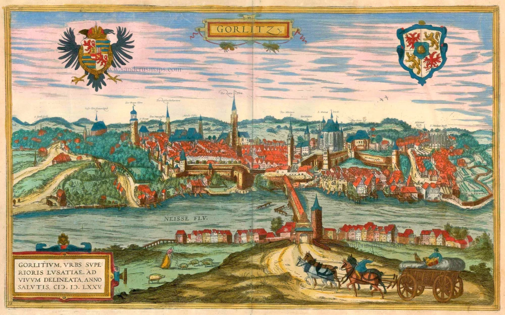
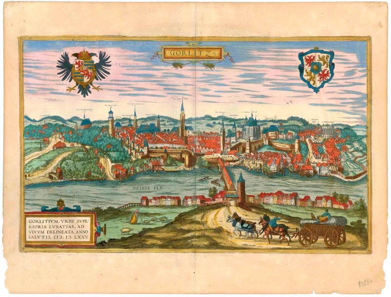


TRANSLATION OF CARTOUCHE TEXT: Görlitz, the city in Upper Lusatia, was drawn true to nature in 1575.
COMMENTARY BY BRAUN: "Görlitz is a splendid city in Upper Lusatia; it is adorned with many beautiful buildings and well fortified with walls and moats, but the ground on which it lies is uneven and mountainous. The River Neisse flows through the city, benefiting the millers, brewers, dyers and other artisans. Spanning this river is a great wooden bridge covered with a roof."
Görlitz is shown from the east looking across the Neisse; this city's impressive silhouette on the river's bank is reproduced in detail, with its many church spires and magnificent half-timbered houses. On the right, above the wooden bridge over the Neisse, which was roofed over in 1566, the city's landmark, the mighty late Gothic hall church of SS Peter and Paul, and on the left, the tall town hall and watchtower. The town prospered due to its location on an important trade route and received a municipal charter around 1200. It was granted the right to brew beer, issue coins, and staple rights for the woad plant (German indigo, principally used to produce blue linen). It reached the height of its political and economic power at the beginning of the 15th century. (Taschen)
Gorlitz - Gorlitium, Urbs Superioris Lusatiae, ad vivum delineata, Anno Salutis MDLXXV.
Item Number: 23284 Authenticity Guarantee
Category: Antique maps > Europe > Germany - Cities
Old, antique bird’s-eye view of Gorlitz by Braun & Hogenberg.
Title: Gorlitz - Gorlitium, Urbs Superioris Lusatiae, ad vivum delineata, Anno Salutis MDLXXV.
Date of the first edition: 1575.
Date of this map: 1597.
Copper engraving, printed on paper.
Size (not including margins): 305 x 495mm (12.01 x 19.49 inches).
Verso: Latin text.
Condition: Excellent, superb old colour.
Condition Rating: A+.
From: Civitates Orbis Terrarum, ... Part 2: De Praecipuis, Totius Universi Urbibus, Liber Secundus. Köln, Bertram Buchholz, 1597. (Van der Krogt 4, 41:1.2)
TRANSLATION OF CARTOUCHE TEXT: Görlitz, the city in Upper Lusatia, was drawn true to nature in 1575.
COMMENTARY BY BRAUN: "Görlitz is a splendid city in Upper Lusatia; it is adorned with many beautiful buildings and well fortified with walls and moats, but the ground on which it lies is uneven and mountainous. The River Neisse flows through the city, benefiting the millers, brewers, dyers and other artisans. Spanning this river is a great wooden bridge covered with a roof."
Görlitz is shown from the east looking across the Neisse; this city's impressive silhouette on the river's bank is reproduced in detail, with its many church spires and magnificent half-timbered houses. On the right, above the wooden bridge over the Neisse, which was roofed over in 1566, the city's landmark, the mighty late Gothic hall church of SS Peter and Paul, and on the left, the tall town hall and watchtower. The town prospered due to its location on an important trade route and received a municipal charter around 1200. It was granted the right to brew beer, issue coins, and staple rights for the woad plant (German indigo, principally used to produce blue linen). It reached the height of its political and economic power at the beginning of the 15th century. (Taschen)
