
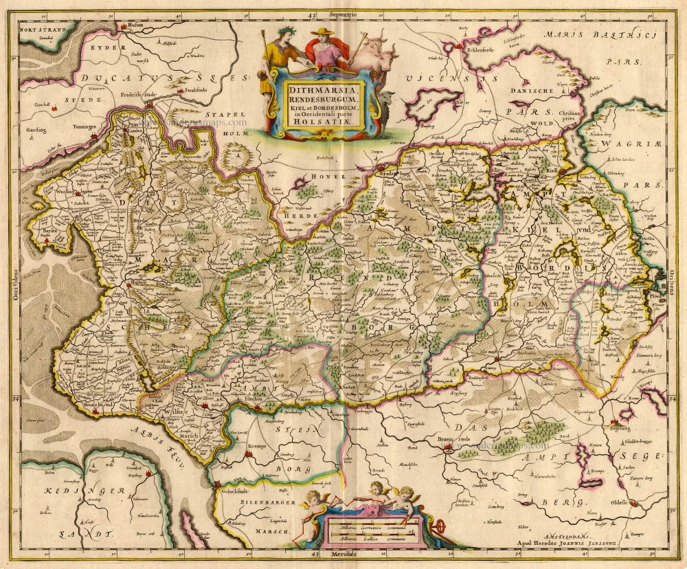
Kiel by Braun & Hogenberg 1588-97
The item displayed on this page has been sold. However, we have a similar map in stock:
Kiel, by Georg Braun and Frans Hogenberg. 1588
Chilonium, vulgo Kyell.
[Item number: 32199]


TRANSLATION OF CARTOUCHE TEXT: Chilonium, commonly called Kiel, is an elegant old city in Holstein on an isthmus in the Baltic Sea, noteworthy for a situation favourable to trade and commerce and the annual gatherings of the Cimbrian nobility.
COMMENTARY BY BRAUN: "Where the Belt meets the Duchy of Schleswig-Holstein and Schleswig, it has numerous bends forming narrow necks of land notably surrounded by water on both sides, which the ancient Greeks called an isthmus. Between these necks of land thrusts the sea to the great advantage of the residents, and it provides merchants and their sea-going vessels with a safe refuge where they can recover from the hardships sustained at sea. Kiel also provides an amenity of this kind, which is used similarly. It is an old city, well-supplied and almost surrounded by water. Its name derives from "Kiell" or "Keyl", which means chisel in German."
From an elevated vantage point and looking south, this view shows the island situation of the city systematically laid out on Kiel Fjord and surrounded by the Kleiner Kiel and pasture land. The centre is dominated by the Gothic church of St Nicolas (A). finished in 1240; it was joined by the church of the Holy Spirit (D) in the 14th century. The Holsten gate in the south led to the mainland. Founded by Count Adolf IV between 1233 and 1242, Kiel became a free city in 1242. Lacking links with inland waterways or good overland routes to larger cities, Kiel attained only regional importance as a trading port. One indication of modest circumstances is the dilapidated condition of the fortifications along the fjord. (Taschen)
Chilonium, vulgo Kyell.
Item Number: 16369 Authenticity Guarantee
Category: Antique maps > Europe > Germany - Cities
Kiel by Braun & Hogenberg.
Title: Chilonium, vulgo Kyell.
lautum atque uetustum Holsatiae, ad Isthmum Maris Balthici Opp Situ, negotiationi peroportuno, et annuis, nobilitatis Cimbricae Comitijs, comendatum.
Date of the first edition: 1588.
Date of this map: 1588-97.
Copper engraving, printed on paper.
Size (not including margins): 300 x 482mm (11.81 x 18.98 inches).
Verso: Latin text.
Condition: Excellent, superb old colour.
Condition Rating: .
From: Liber quartus Urbium Praecipuarum totius Mundi. Cologne, 1588-97. (Koeman, B&H4, Van der Krogt 4, 41:1.4)
TRANSLATION OF CARTOUCHE TEXT: Chilonium, commonly called Kiel, is an elegant old city in Holstein on an isthmus in the Baltic Sea, noteworthy for a situation favourable to trade and commerce and the annual gatherings of the Cimbrian nobility.
COMMENTARY BY BRAUN: "Where the Belt meets the Duchy of Schleswig-Holstein and Schleswig, it has numerous bends forming narrow necks of land notably surrounded by water on both sides, which the ancient Greeks called an isthmus. Between these necks of land thrusts the sea to the great advantage of the residents, and it provides merchants and their sea-going vessels with a safe refuge where they can recover from the hardships sustained at sea. Kiel also provides an amenity of this kind, which is used similarly. It is an old city, well-supplied and almost surrounded by water. Its name derives from "Kiell" or "Keyl", which means chisel in German."
From an elevated vantage point and looking south, this view shows the island situation of the city systematically laid out on Kiel Fjord and surrounded by the Kleiner Kiel and pasture land. The centre is dominated by the Gothic church of St Nicolas (A). finished in 1240; it was joined by the church of the Holy Spirit (D) in the 14th century. The Holsten gate in the south led to the mainland. Founded by Count Adolf IV between 1233 and 1242, Kiel became a free city in 1242. Lacking links with inland waterways or good overland routes to larger cities, Kiel attained only regional importance as a trading port. One indication of modest circumstances is the dilapidated condition of the fortifications along the fjord. (Taschen)
Related items
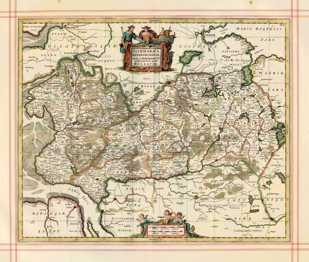
Dithmarsia, Rendesburgum, Kiel et Bordesholm in Occidentali parte Holsatiae 1680
Dithmarschen, Rendsburg, Kiel by J. Janssonius, published by Moses Pitt and J. Janssonius-Waesberge.
[Item number: 1705]
Dithmarsia, Rendesburgum, Kiel et Bordesholm in Occidentali parte Holsatiae c. 1680.
Dithmarschen, Rendsburg, Kiel, by Hondius H. - Janssonius J
[Item number: 18720]