
Krempe - Rendsburg by Braun G. & Hogenberg F. c. 1593
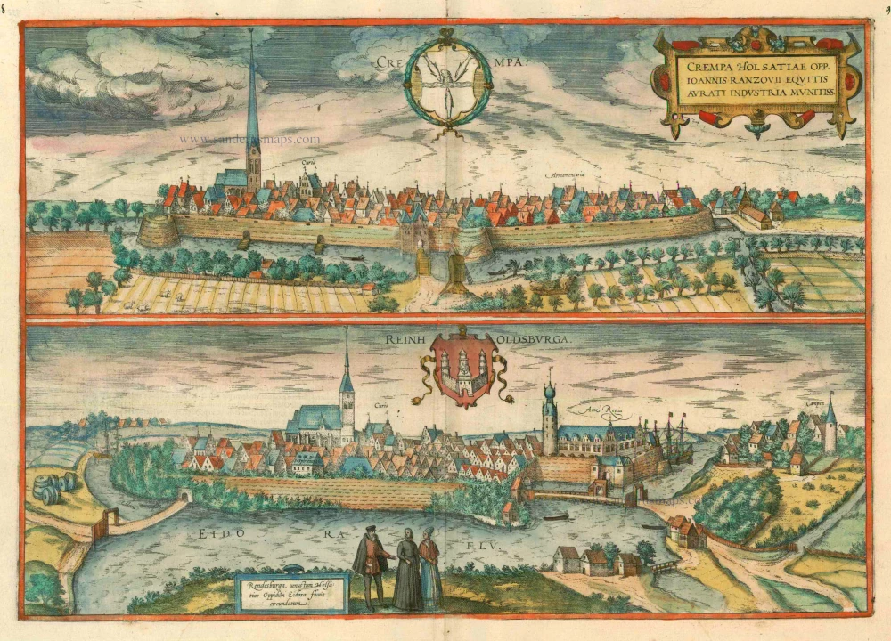
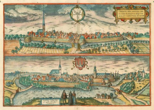
KREMPE
TRANSLATION OF CARTOUCHE TEXT: Krempe, at the instigation of Joannes Rantzau, Knight of the Golden Helm, a heavily Holstein town.
COMMENTARY BY BRAUN: "Krempe, a town in Holstein, derives its name from the heavily travelled waters that flow through the midst of it to the Rivers Stör and Elbe. It was incorporated as a city and granted its coat of arms in 1271 by Gerhard, the first Count of Schauenburg and Holstein. In 1535, during the Count's War, it was fortified by the knight Johannes Rantzau with moated ramparts and bastions and is now not the least of the Holstein fortifications. Its inhabitants are merchants for the most part, but they also engage in farming."
Looking from the north, the viewer sees a town mentioned for the first time in 1240, made a free city in 1250 and fortified in the 16th century. The huddle of patrician townhouse gables is topped only by the church of St Peter and the magnificent town hall (Curia), attesting to the heyday of this trading centre from the 13th to the 16th century. By the time this work went to print, ships from Krempe were sailing as far as the Mediterranean and even to Arkhangelsk on the White Sea and Krempe merchants had opened trading posts in England, France and Portugal. Unfortunately, the founding of Glückstadt put paid for the town's prosperity. To add insult to injury, the Au silted up - by 1696, Krempe was bankrupt. Plagues, wars and enforced levies did the rest, leaving the city to sink into the tiredness of a rural backwater.
RENDSBURG
CARTOUCHE: Rendsburg, a fine Holstein town encircled by the River Eider.
COMMENTARY BY BRAUN: "The city is situated in a highly advantageous location. Indeed the River Eider flows all around it and through it with so many bends that one can board a ship there and sail for Spain, France, England and the Netherlands. The tower, which is still visible today next to the castle, was built by Gerhard the Great, Count of Holstein and Schauenburg, in 1230. Afterwards, it was sold to the Kings of Denmark, had the existing fortifications erected."
Viewed from the north and a slightly elevated vantage point, the town is situated on an island in the River Eider and fortified with earthworks. The church of St Mary, the first Gothic hall built in Holstein, and the 16th-century town hall is easy to pick out at the island's centre. The three-masted ships in the background indicate far-flung North Sea and Baltic trade links. Rendsburg, which was first mentioned in 1199 and was made a free city in 1252/53, began as a settlement on a ford over the Eider, marking the border between Schleswig and Holstein and was defended by the Reinholdsburg. This 12th-century border fortress was converted into a Renaissance palace in the late 16th century. However, the construction of the North Sea-Baltic Canal in 1887-1895 made the water-level sink by 2 m so that nothing indicates today that Rendsburg was once on an island.
Braun G. & Hogenberg F. and the Civitates Orbis Terrarum.
The Civitates Orbis Terrarum, also known as the 'Braun & Hogenberg', is a six-volume town atlas and the most excellent book of town views and plans ever published: 363 engravings, sometimes beautifully coloured. It was one of the best-selling works in the last quarter of the 16th century. Georg Braun, a skilled writer, wrote the text accompanying the plans and views on the verso. Many plates were engraved after the original drawings of a professional artist, Joris Hoefnagel (1542-1600). The first volume was published in Latin in 1572 and the sixth in 1617. Frans Hogenberg, a talented engraver, created the tables for volumes I through IV, and Simon van den Neuwel made those for volumes V and VI. Other contributors were cartographers Daniel Freese and Heinrich Rantzau, who provided valuable geographical information. Works by Jacob van Deventer, Sebastian Münster, and Johannes Stumpf were also used as references. Translations appeared in German and French, making the atlas accessible to a broader audience.
Since its original publication of volume 1 in 1572, the Civitates Orbis Terrarum has left an indelible mark on the history of cartography. Seven more editions followed the first volume in 1575, 1577, 1582, 1588, 1593, 1599, and 1612. Vol.2, initially released in 1575, saw subsequent editions in 1597 and 1612. The subsequent volumes, each a treasure trove of historical insights, graced the world in 1581, 1588, 1593, 1599, and 1606. The German translation of the first volume, a testament to its widespread appeal, debuted in 1574, followed by the French edition in 1575.
Several printers were involved: Theodor Graminaeus, Heinrich von Aich, Gottfried von Kempen, Johannis Sinniger, Bertram Buchholtz, and Peter von Brachel, all of whom worked in Cologne.
Georg Braun (1541-1622)
Georg Braun, the author of the text accompanying the plans and views in the Civitates Orbis Terrarum, was born in Cologne in 1541. After his studies in Cologne, he entered the Jesuit Order as a novice, indicating his commitment to learning and intellectual pursuits. In 1561, he obtained his bachelor's degree; in 1562, he received his Magister Artium, further demonstrating his academic achievements. Although he left the Jesuit Order, he continued his studies in theology, gaining a licentiate in theology. His theological background likely influenced the content and tone of the text in the Civitates Orbis Terrarum, adding a unique perspective to the work.
Frans Hogenberg (1535-1590)
Frans Hogenberg was a Flemish and German painter, engraver, and mapmaker. He was born in Mechelen as the son of Nicolaas Hogenberg.
By the end of the 1560s, Frans Hogenberg was employed upon Abraham Ortelius's Theatrum Orbis Terrarum, published in 1570; he is named an engraver of numerous maps. In 1568, he was banned from Antwerp by the Duke of Alva and travelled to London, where he stayed a few years before emigrating to Cologne. He immediately embarked on his two most important works, the Civitates, published in 1572 and the Geschichtsblätter, which appeared in several series from 1569 until about 1587.
Thanks to large-scale projects like the Geschichtsblätter and the Civitates, Hogenberg's social circumstances improved with each passing year. He died as a wealthy man in Cologne in 1590.
Crempa Holsatiae Opp. ... [on sheet with] Reinholdsburga - Rendesburga ..
Item Number: 15655 Authenticity Guarantee
Category: Antique maps > Europe > Germany - Cities
Antique map with two bird's-eye views by Braun and Hogenberg: Krempe and Rendsburg.
Title: Crempa Holsatiae Opp. ... [on sheet with] Reinholdsburga - Rendesburga ..
Date of the first edition: 1588.
Date of this map: c. 1593.
Copper engraving, printed on paper.
Size (not including margins): 343 x 490mm (13.5 x 19.29 inches).
Verso: French text.
Condition: Original coloured, excellent.
Condition Rating: A+.
From: Liber Quartus - Théatre des Principales Villes de tout L'Univers. Cologne, c. 1593. (Van der Krogt 4, 41:3.4)
KREMPE
TRANSLATION OF CARTOUCHE TEXT: Krempe, at the instigation of Joannes Rantzau, Knight of the Golden Helm, a heavily Holstein town.
COMMENTARY BY BRAUN: "Krempe, a town in Holstein, derives its name from the heavily travelled waters that flow through the midst of it to the Rivers Stör and Elbe. It was incorporated as a city and granted its coat of arms in 1271 by Gerhard, the first Count of Schauenburg and Holstein. In 1535, during the Count's War, it was fortified by the knight Johannes Rantzau with moated ramparts and bastions and is now not the least of the Holstein fortifications. Its inhabitants are merchants for the most part, but they also engage in farming."
Looking from the north, the viewer sees a town mentioned for the first time in 1240, made a free city in 1250 and fortified in the 16th century. The huddle of patrician townhouse gables is topped only by the church of St Peter and the magnificent town hall (Curia), attesting to the heyday of this trading centre from the 13th to the 16th century. By the time this work went to print, ships from Krempe were sailing as far as the Mediterranean and even to Arkhangelsk on the White Sea and Krempe merchants had opened trading posts in England, France and Portugal. Unfortunately, the founding of Glückstadt put paid for the town's prosperity. To add insult to injury, the Au silted up - by 1696, Krempe was bankrupt. Plagues, wars and enforced levies did the rest, leaving the city to sink into the tiredness of a rural backwater.
RENDSBURG
CARTOUCHE: Rendsburg, a fine Holstein town encircled by the River Eider.
COMMENTARY BY BRAUN: "The city is situated in a highly advantageous location. Indeed the River Eider flows all around it and through it with so many bends that one can board a ship there and sail for Spain, France, England and the Netherlands. The tower, which is still visible today next to the castle, was built by Gerhard the Great, Count of Holstein and Schauenburg, in 1230. Afterwards, it was sold to the Kings of Denmark, had the existing fortifications erected."
Viewed from the north and a slightly elevated vantage point, the town is situated on an island in the River Eider and fortified with earthworks. The church of St Mary, the first Gothic hall built in Holstein, and the 16th-century town hall is easy to pick out at the island's centre. The three-masted ships in the background indicate far-flung North Sea and Baltic trade links. Rendsburg, which was first mentioned in 1199 and was made a free city in 1252/53, began as a settlement on a ford over the Eider, marking the border between Schleswig and Holstein and was defended by the Reinholdsburg. This 12th-century border fortress was converted into a Renaissance palace in the late 16th century. However, the construction of the North Sea-Baltic Canal in 1887-1895 made the water-level sink by 2 m so that nothing indicates today that Rendsburg was once on an island.
Braun G. & Hogenberg F. and the Civitates Orbis Terrarum.
The Civitates Orbis Terrarum, also known as the 'Braun & Hogenberg', is a six-volume town atlas and the most excellent book of town views and plans ever published: 363 engravings, sometimes beautifully coloured. It was one of the best-selling works in the last quarter of the 16th century. Georg Braun, a skilled writer, wrote the text accompanying the plans and views on the verso. Many plates were engraved after the original drawings of a professional artist, Joris Hoefnagel (1542-1600). The first volume was published in Latin in 1572 and the sixth in 1617. Frans Hogenberg, a talented engraver, created the tables for volumes I through IV, and Simon van den Neuwel made those for volumes V and VI. Other contributors were cartographers Daniel Freese and Heinrich Rantzau, who provided valuable geographical information. Works by Jacob van Deventer, Sebastian Münster, and Johannes Stumpf were also used as references. Translations appeared in German and French, making the atlas accessible to a broader audience.
Since its original publication of volume 1 in 1572, the Civitates Orbis Terrarum has left an indelible mark on the history of cartography. Seven more editions followed the first volume in 1575, 1577, 1582, 1588, 1593, 1599, and 1612. Vol.2, initially released in 1575, saw subsequent editions in 1597 and 1612. The subsequent volumes, each a treasure trove of historical insights, graced the world in 1581, 1588, 1593, 1599, and 1606. The German translation of the first volume, a testament to its widespread appeal, debuted in 1574, followed by the French edition in 1575.
Several printers were involved: Theodor Graminaeus, Heinrich von Aich, Gottfried von Kempen, Johannis Sinniger, Bertram Buchholtz, and Peter von Brachel, all of whom worked in Cologne.
Georg Braun (1541-1622)
Georg Braun, the author of the text accompanying the plans and views in the Civitates Orbis Terrarum, was born in Cologne in 1541. After his studies in Cologne, he entered the Jesuit Order as a novice, indicating his commitment to learning and intellectual pursuits. In 1561, he obtained his bachelor's degree; in 1562, he received his Magister Artium, further demonstrating his academic achievements. Although he left the Jesuit Order, he continued his studies in theology, gaining a licentiate in theology. His theological background likely influenced the content and tone of the text in the Civitates Orbis Terrarum, adding a unique perspective to the work.
Frans Hogenberg (1535-1590)
Frans Hogenberg was a Flemish and German painter, engraver, and mapmaker. He was born in Mechelen as the son of Nicolaas Hogenberg.
By the end of the 1560s, Frans Hogenberg was employed upon Abraham Ortelius's Theatrum Orbis Terrarum, published in 1570; he is named an engraver of numerous maps. In 1568, he was banned from Antwerp by the Duke of Alva and travelled to London, where he stayed a few years before emigrating to Cologne. He immediately embarked on his two most important works, the Civitates, published in 1572 and the Geschichtsblätter, which appeared in several series from 1569 until about 1587.
Thanks to large-scale projects like the Geschichtsblätter and the Civitates, Hogenberg's social circumstances improved with each passing year. He died as a wealthy man in Cologne in 1590.
Related items

Dithmarsia, Rendesburgum, Kiel et Bordesholm in Occidentali parte Holsatiae 1680
Dithmarschen, Rendsburg, Kiel by J. Janssonius, published by Moses Pitt and J. Janssonius-Waesberge.
[Item number: 1705]

Dithmarsia, Rendesburgum, Kiel et Bordesholm in Occidentali parte Holsatiae c. 1680.
Dithmarschen, Rendsburg, Kiel, by Hondius H. - Janssonius J
[Item number: 18720]

Crempa Holsatiae Opp. ... [on sheet with] Reinholdsburga - Rendesburga .. 1588-97
Krempe and Rendsburg, by Georg Braun and Frans Hogenberg.
[Item number: 24109]