
Staden, by Georg Braun & Frans Hogenberg. c. 1610
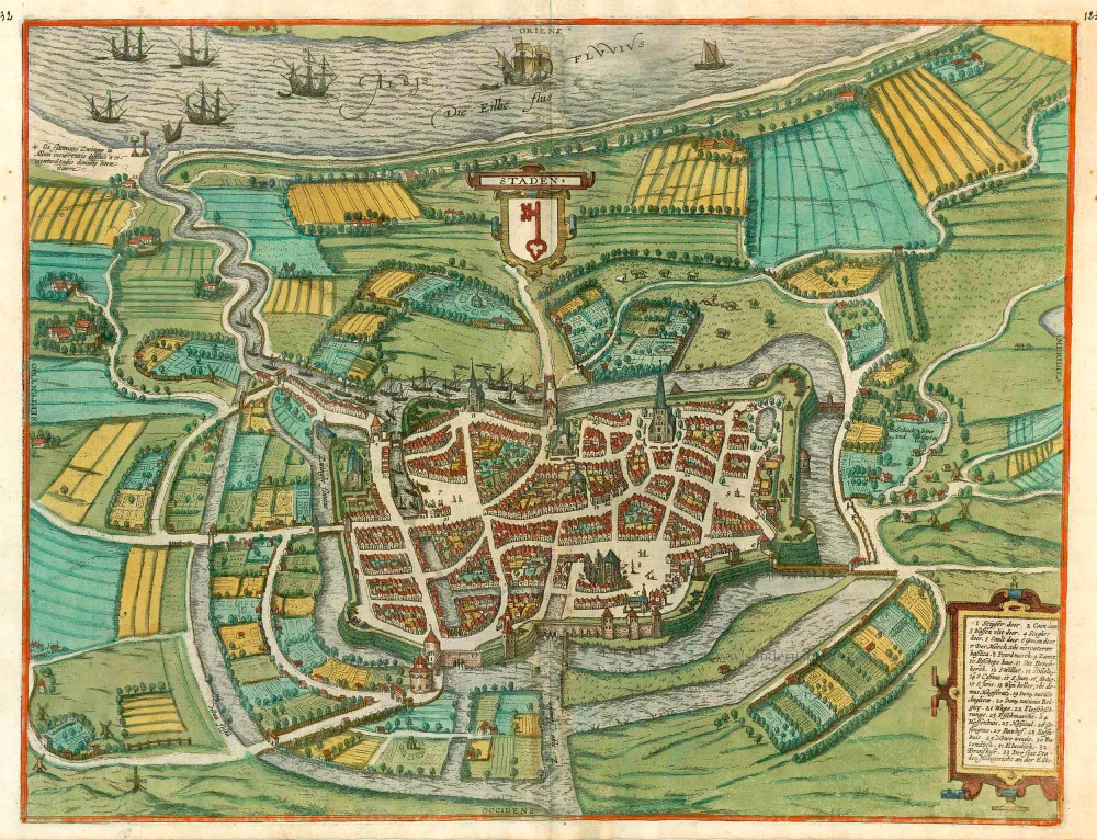


COMMENTARY BY BRAUN (on verso): "The location of the town is not bad: it has healthy air and a convenient harbour that allows long-distance trade. It has richly populated suburbs, and outside the town magnificent, beautifully situated estates and gardens, as wel as a higher court, whose visible signs, namely gallows and wheels, were displayed on one side of the town on the bank of the Elbe and one on the other side on the hill in front of the large gate, the first to punish pirates and the second to punish other wrongdoers."
Stade is seen in bird's-eye view from the west, looking across the Elbe marshes towards the River Elbe itself, which due to the elevated angle appears relatively near but which is in fact some 4 km distant. The Schwinge River flows around the town and - in combination with the moat and the ramparts - formed part of Stade's defences. The harbour was built around 1000, and after Emperor Otto IV granted the town its charter in 1209, Stade joined the Hanseatic League. Stade possessed the right to pass the death sentence, i.e. the right to carry out mutilations and executions, as evidenced top left by the gallows standing at the confluence of the Schwinge with the Elbe. In 1659 some two-thirds of the town burned down, so that the present map now possesses a historical character. (Taschen)
Braun G. & Hogenberg F. and the Civitates Orbis Terrarum.
The Civitates Orbis Terrarum, also known as the 'Braun & Hogenberg', is a six-volume town atlas and the most excellent book of town views and plans ever published: 363 engravings, sometimes beautifully coloured. It was one of the best-selling works in the last quarter of the 16th century. Georg Braun, a skilled writer, wrote the text accompanying the plans and views on the verso. Many plates were engraved after the original drawings of a professional artist, Joris Hoefnagel (1542-1600). The first volume was published in Latin in 1572 and the sixth in 1617. Frans Hogenberg, a talented engraver, created the tables for volumes I through IV, and Simon van den Neuwel made those for volumes V and VI. Other contributors were cartographers Daniel Freese and Heinrich Rantzau, who provided valuable geographical information. Works by Jacob van Deventer, Sebastian Münster, and Johannes Stumpf were also used as references. Translations appeared in German and French, making the atlas accessible to a broader audience.
Since its original publication of volume 1 in 1572, the Civitates Orbis Terrarum has left an indelible mark on the history of cartography. Seven more editions followed the first volume in 1575, 1577, 1582, 1588, 1593, 1599, and 1612. Vol.2, initially released in 1575, saw subsequent editions in 1597 and 1612. The subsequent volumes, each a treasure trove of historical insights, graced the world in 1581, 1588, 1593, 1599, and 1606. The German translation of the first volume, a testament to its widespread appeal, debuted in 1574, followed by the French edition in 1575.
Several printers were involved: Theodor Graminaeus, Heinrich von Aich, Gottfried von Kempen, Johannis Sinniger, Bertram Buchholtz, and Peter von Brachel, all of whom worked in Cologne.
Georg Braun (1541-1622)
Georg Braun, the author of the text accompanying the plans and views in the Civitates Orbis Terrarum, was born in Cologne in 1541. After his studies in Cologne, he entered the Jesuit Order as a novice, indicating his commitment to learning and intellectual pursuits. In 1561, he obtained his bachelor's degree; in 1562, he received his Magister Artium, further demonstrating his academic achievements. Although he left the Jesuit Order, he continued his studies in theology, gaining a licentiate in theology. His theological background likely influenced the content and tone of the text in the Civitates Orbis Terrarum, adding a unique perspective to the work.
Frans Hogenberg (1535-1590)
Frans Hogenberg was a Flemish and German painter, engraver, and mapmaker. He was born in Mechelen as the son of Nicolaas Hogenberg.
By the end of the 1560s, Frans Hogenberg was employed upon Abraham Ortelius's Theatrum Orbis Terrarum, published in 1570; he is named an engraver of numerous maps. In 1568, he was banned from Antwerp by the Duke of Alva and travelled to London, where he stayed a few years before emigrating to Cologne. He immediately embarked on his two most important works, the Civitates, published in 1572 and the Geschichtsblätter, which appeared in several series from 1569 until about 1587.
Thanks to large-scale projects like the Geschichtsblätter and the Civitates, Hogenberg's social circumstances improved with each passing year. He died as a wealthy man in Cologne in 1590.
Staden.
Item Number: 24593 Authenticity Guarantee
Category: Antique maps > Europe > Germany - Cities
Antique map - bird's-eye view plan of Staden, by Georg Braun & Frans Hogenberg.
Alter, antiker Stadtplan in der Vogelschau von Stade, von Georg Braun & Frans Hogenberg..
Date of the first edition: 1596
Date of this map: c. 1610
Copper engraving, printed on paper.
Size (not including margins): 39 x 50.5cm (15.2 x 19.7 inches)
Verso text: French
Condition: Original coloured, excellent.
Condition Rating: A
References: Van der Krogt 4, #4070; Fauser, #13256; Taschen, Br. Hog., p.392.
From: Théâtre des Principales Villes de tout l'Univers. Tome 5. c. 1610.
COMMENTARY BY BRAUN (on verso): "The location of the town is not bad: it has healthy air and a convenient harbour that allows long-distance trade. It has richly populated suburbs, and outside the town magnificent, beautifully situated estates and gardens, as wel as a higher court, whose visible signs, namely gallows and wheels, were displayed on one side of the town on the bank of the Elbe and one on the other side on the hill in front of the large gate, the first to punish pirates and the second to punish other wrongdoers."
Stade is seen in bird's-eye view from the west, looking across the Elbe marshes towards the River Elbe itself, which due to the elevated angle appears relatively near but which is in fact some 4 km distant. The Schwinge River flows around the town and - in combination with the moat and the ramparts - formed part of Stade's defences. The harbour was built around 1000, and after Emperor Otto IV granted the town its charter in 1209, Stade joined the Hanseatic League. Stade possessed the right to pass the death sentence, i.e. the right to carry out mutilations and executions, as evidenced top left by the gallows standing at the confluence of the Schwinge with the Elbe. In 1659 some two-thirds of the town burned down, so that the present map now possesses a historical character. (Taschen)
Braun G. & Hogenberg F. and the Civitates Orbis Terrarum.
The Civitates Orbis Terrarum, also known as the 'Braun & Hogenberg', is a six-volume town atlas and the most excellent book of town views and plans ever published: 363 engravings, sometimes beautifully coloured. It was one of the best-selling works in the last quarter of the 16th century. Georg Braun, a skilled writer, wrote the text accompanying the plans and views on the verso. Many plates were engraved after the original drawings of a professional artist, Joris Hoefnagel (1542-1600). The first volume was published in Latin in 1572 and the sixth in 1617. Frans Hogenberg, a talented engraver, created the tables for volumes I through IV, and Simon van den Neuwel made those for volumes V and VI. Other contributors were cartographers Daniel Freese and Heinrich Rantzau, who provided valuable geographical information. Works by Jacob van Deventer, Sebastian Münster, and Johannes Stumpf were also used as references. Translations appeared in German and French, making the atlas accessible to a broader audience.
Since its original publication of volume 1 in 1572, the Civitates Orbis Terrarum has left an indelible mark on the history of cartography. Seven more editions followed the first volume in 1575, 1577, 1582, 1588, 1593, 1599, and 1612. Vol.2, initially released in 1575, saw subsequent editions in 1597 and 1612. The subsequent volumes, each a treasure trove of historical insights, graced the world in 1581, 1588, 1593, 1599, and 1606. The German translation of the first volume, a testament to its widespread appeal, debuted in 1574, followed by the French edition in 1575.
Several printers were involved: Theodor Graminaeus, Heinrich von Aich, Gottfried von Kempen, Johannis Sinniger, Bertram Buchholtz, and Peter von Brachel, all of whom worked in Cologne.
Georg Braun (1541-1622)
Georg Braun, the author of the text accompanying the plans and views in the Civitates Orbis Terrarum, was born in Cologne in 1541. After his studies in Cologne, he entered the Jesuit Order as a novice, indicating his commitment to learning and intellectual pursuits. In 1561, he obtained his bachelor's degree; in 1562, he received his Magister Artium, further demonstrating his academic achievements. Although he left the Jesuit Order, he continued his studies in theology, gaining a licentiate in theology. His theological background likely influenced the content and tone of the text in the Civitates Orbis Terrarum, adding a unique perspective to the work.
Frans Hogenberg (1535-1590)
Frans Hogenberg was a Flemish and German painter, engraver, and mapmaker. He was born in Mechelen as the son of Nicolaas Hogenberg.
By the end of the 1560s, Frans Hogenberg was employed upon Abraham Ortelius's Theatrum Orbis Terrarum, published in 1570; he is named an engraver of numerous maps. In 1568, he was banned from Antwerp by the Duke of Alva and travelled to London, where he stayed a few years before emigrating to Cologne. He immediately embarked on his two most important works, the Civitates, published in 1572 and the Geschichtsblätter, which appeared in several series from 1569 until about 1587.
Thanks to large-scale projects like the Geschichtsblätter and the Civitates, Hogenberg's social circumstances improved with each passing year. He died as a wealthy man in Cologne in 1590.
