
Eckernförde, by Braun & Hogenberg. 1596-1640
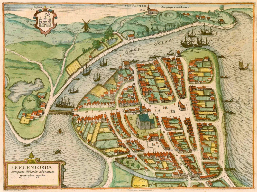


TRANSLATION OF CARTOUCHE TEXT: Eckernförde is an ancient Holstein town on a peninsula in the sea.
COMMENTARY BY BRAUN: "Eckernförde is a small town in Holstein, situated opposite Eckernborch castle to the north; this latter was destroyed in the Danish War, but its foundations, moats and ramparts can still be made out quite clearly. Erckernförde lies on a peninsula in the Baltic, wherefore it has a safe and convenient harbour. However, bad beer is brewed there, which is useful for purging the body and is exported and sold to Denmark and the Duchy of Schleswig and Holstein. Although the town is surrounded by salt water, it has fresh water fountains on the streets from which the beer is brewed."
The bird's-eye view from the south clearly shows the town's layout, which was probably founded in the 13th century on a bay northwest of Kiel. At the end of the 12th century, the king of Denmark had a fortress built on Eckernförde Bay to defend the adjacent trade route - before its destruction, it faced the town from near the top of the picture, a site now occupied by the bathing resort of Borby. Visible on the top of the hill, not far from this point, is Borby church, the town's oldest surviving work of architecture. The church of St Nicholas in the town centre dates back to the start of the 13th century. Eckernförde was first mentioned as a town in 1302. In the Middle Ages and the early modern era, the port was important primarily as a point of transhipment for agricultural produce. In 1864 it was taken from Denmark and given to Prussia, whereby Eckernförde lost a large part of its trade. (Taschen)
Braun G. & Hogenberg F. and the Civitates Orbis Terrarum.
The Civitates Orbis Terrarum, also known as the 'Braun & Hogenberg', is a six-volume town atlas and the most excellent book of town views and plans ever published: 363 engravings, sometimes beautifully coloured. It was one of the best-selling works in the last quarter of the 16th century. Georg Braun, a skilled writer, wrote the text accompanying the plans and views on the verso. Many plates were engraved after the original drawings of a professional artist, Joris Hoefnagel (1542-1600). The first volume was published in Latin in 1572 and the sixth in 1617. Frans Hogenberg, a talented engraver, created the tables for volumes I through IV, and Simon van den Neuwel made those for volumes V and VI. Other contributors were cartographers Daniel Freese and Heinrich Rantzau, who provided valuable geographical information. Works by Jacob van Deventer, Sebastian Münster, and Johannes Stumpf were also used as references. Translations appeared in German and French, making the atlas accessible to a wider audience.
Since its original publication of volume 1 in 1572, the Civitates Orbis Terrarum has left an indelible mark on the history of cartography. The first volume was followed by seven more editions in 1575, 1577, 1582, 1588, 1593, 1599, and 1612. Vol.2, initially released in 1575, saw subsequent editions in 1597 and 1612. The subsequent volumes, each a treasure trove of historical insights, graced the world in 1581, 1588, 1593, 1599, and 1606. The German translation of the first volume, a testament to its widespread appeal, debuted in 1574, followed by the French edition in 1575.
Several printers were involved: Theodor Graminaeus, Heinrich von Aich, Gottfried von Kempen, Johannis Sinniger, Bertram Buchholtz, and Peter von Brachel, all of whom worked in Cologne.
Georg Braun (1541-1622)
Georg Braun, the author of the text accompanying the plans and views in the Civitates Orbis Terrarum, was born in Cologne in 1541. After his studies in Cologne, he entered the Jesuit Order as a novice, indicating his commitment to learning and intellectual pursuits. In 1561, he obtained his bachelor's degree; in 1562, he received his Magister Artium, further demonstrating his academic achievements. Although he left the Jesuit Order, he continued his studies in theology, gaining a licentiate in theology. His theological background likely influenced the content and tone of the text in the Civitates Orbis Terrarum, adding a unique perspective to the work.
Frans Hogenberg (1535-1590)
Frans Hogenberg was a Flemish and German painter, engraver, and mapmaker. He was born in Mechelen as the son of Nicolaas Hogenberg.
By the end of the 1560s, Frans Hogenberg was employed upon Abraham Ortelius's Theatrum Orbis Terrarum, published in 1570; he is named an engraver of numerous maps. In 1568, he was banned from Antwerp by the Duke of Alva and travelled to London, where he stayed a few years before emigrating to Cologne. He immediately embarked on his two most important works, the Civitates, published in 1572 and the Geschichtsblätter, which appeared in several series from 1569 until about 1587.
Thanks to large-scale projects like the Geschichtsblätter and the Civitates, Hogenberg's social circumstances improved with each passing year. He died as a wealthy man in Cologne in 1590.
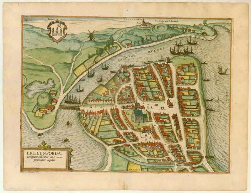
Ekelenforda antiquum Holsatiae ad Oceanum peninsulare oppidum.
Item Number: 22085 Authenticity Guarantee
Category: Antique maps > Europe > Germany - Cities
Old, antique map of Eckernförde by Braun & Hogenberg.
Title: Ekelenforda antiquum Holsatiae ad Oceanum peninsulare oppidum.
Date of the first edition: 1596.
Date of this map: 1596-1640.
Copper engraving, printed on paper.
Size (not including margins): 355 x 475mm (13.98 x 18.7 inches).
Verso: Latin text.
Condition: Original coloured, excellent.
Condition Rating: B.
From: Civitates Orbis Terrarum, ... Part 5. Köln, 1596-1640.
TRANSLATION OF CARTOUCHE TEXT: Eckernförde is an ancient Holstein town on a peninsula in the sea.
COMMENTARY BY BRAUN: "Eckernförde is a small town in Holstein, situated opposite Eckernborch castle to the north; this latter was destroyed in the Danish War, but its foundations, moats and ramparts can still be made out quite clearly. Erckernförde lies on a peninsula in the Baltic, wherefore it has a safe and convenient harbour. However, bad beer is brewed there, which is useful for purging the body and is exported and sold to Denmark and the Duchy of Schleswig and Holstein. Although the town is surrounded by salt water, it has fresh water fountains on the streets from which the beer is brewed."
The bird's-eye view from the south clearly shows the town's layout, which was probably founded in the 13th century on a bay northwest of Kiel. At the end of the 12th century, the king of Denmark had a fortress built on Eckernförde Bay to defend the adjacent trade route - before its destruction, it faced the town from near the top of the picture, a site now occupied by the bathing resort of Borby. Visible on the top of the hill, not far from this point, is Borby church, the town's oldest surviving work of architecture. The church of St Nicholas in the town centre dates back to the start of the 13th century. Eckernförde was first mentioned as a town in 1302. In the Middle Ages and the early modern era, the port was important primarily as a point of transhipment for agricultural produce. In 1864 it was taken from Denmark and given to Prussia, whereby Eckernförde lost a large part of its trade. (Taschen)
Braun G. & Hogenberg F. and the Civitates Orbis Terrarum.
The Civitates Orbis Terrarum, also known as the 'Braun & Hogenberg', is a six-volume town atlas and the most excellent book of town views and plans ever published: 363 engravings, sometimes beautifully coloured. It was one of the best-selling works in the last quarter of the 16th century. Georg Braun, a skilled writer, wrote the text accompanying the plans and views on the verso. Many plates were engraved after the original drawings of a professional artist, Joris Hoefnagel (1542-1600). The first volume was published in Latin in 1572 and the sixth in 1617. Frans Hogenberg, a talented engraver, created the tables for volumes I through IV, and Simon van den Neuwel made those for volumes V and VI. Other contributors were cartographers Daniel Freese and Heinrich Rantzau, who provided valuable geographical information. Works by Jacob van Deventer, Sebastian Münster, and Johannes Stumpf were also used as references. Translations appeared in German and French, making the atlas accessible to a wider audience.
Since its original publication of volume 1 in 1572, the Civitates Orbis Terrarum has left an indelible mark on the history of cartography. The first volume was followed by seven more editions in 1575, 1577, 1582, 1588, 1593, 1599, and 1612. Vol.2, initially released in 1575, saw subsequent editions in 1597 and 1612. The subsequent volumes, each a treasure trove of historical insights, graced the world in 1581, 1588, 1593, 1599, and 1606. The German translation of the first volume, a testament to its widespread appeal, debuted in 1574, followed by the French edition in 1575.
Several printers were involved: Theodor Graminaeus, Heinrich von Aich, Gottfried von Kempen, Johannis Sinniger, Bertram Buchholtz, and Peter von Brachel, all of whom worked in Cologne.
Georg Braun (1541-1622)
Georg Braun, the author of the text accompanying the plans and views in the Civitates Orbis Terrarum, was born in Cologne in 1541. After his studies in Cologne, he entered the Jesuit Order as a novice, indicating his commitment to learning and intellectual pursuits. In 1561, he obtained his bachelor's degree; in 1562, he received his Magister Artium, further demonstrating his academic achievements. Although he left the Jesuit Order, he continued his studies in theology, gaining a licentiate in theology. His theological background likely influenced the content and tone of the text in the Civitates Orbis Terrarum, adding a unique perspective to the work.
Frans Hogenberg (1535-1590)
Frans Hogenberg was a Flemish and German painter, engraver, and mapmaker. He was born in Mechelen as the son of Nicolaas Hogenberg.
By the end of the 1560s, Frans Hogenberg was employed upon Abraham Ortelius's Theatrum Orbis Terrarum, published in 1570; he is named an engraver of numerous maps. In 1568, he was banned from Antwerp by the Duke of Alva and travelled to London, where he stayed a few years before emigrating to Cologne. He immediately embarked on his two most important works, the Civitates, published in 1572 and the Geschichtsblätter, which appeared in several series from 1569 until about 1587.
Thanks to large-scale projects like the Geschichtsblätter and the Civitates, Hogenberg's social circumstances improved with each passing year. He died as a wealthy man in Cologne in 1590.