
Saarburg - Pfalzel, by Braun & Hogenberg. 1596-1640
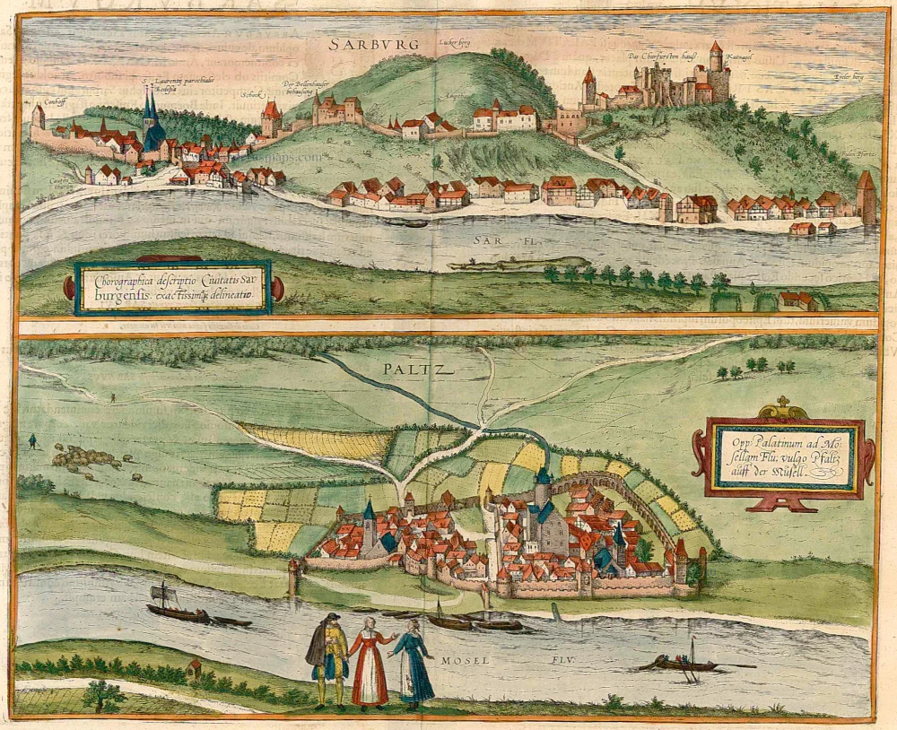


SAARBURG
CARTOUCHE: Accurate overview of the town of Saarburg.
COMMENTARY BY BRAUN (on verso): "The small town of Saarburg in the archbishopric of Trier, situated on the Saar, is little known amongst chroniclers and hence almost nothing is written about its origins and background. [...] A stone bridge called the Kunz bridge after the neighbouring village crosses the Saar not far from the Moselle. [...] At both ends of the bridge stands a tower in which watch is kept."
The Trier electoral palace and the town around it are seen from Beurig on the right bank of the Saar, today a suburb of Saarburg castle (top right), the later residence of the Trier archbishops, is first mentioned in the 10th century, although the settlement that sprang up beneath it was granted its municipal charter as early as 1291. In the 16th century, the town comprised 100 homes of ordinary citizens (not including those of the nobility or clergy). On the left, the parish church of St Lawrence lies near Saarburg's main attraction, a waterfall, where the Leuk Stream plunges 20 m over rocks. The Kautenturm, on the far left, is a tower that today marks the edge of the Old Town. Saarburg, in the Rhineland-Palatinate, currently has some 6,000 inhabitants.
PFALZEL AN DER MOSEL
CARTOUCHE: The town of Palatinum ad Mosellam, known in German as Pfalzel an der Mosel.
COMMENTARY BY BRAUN (on verso): "Not far from Trier, further down the Moselle on the left bank, lies a small town with a castle called Pfalzel. Its origins are thought to date from the time of King Dagobert in France. In ancient manuscripts and chronicles in the Horrem monastery, at least, it is written that Pfalzel numbered amongst the suburbs of Trier in AD 642, around which time the bishop of Trier furnished this place with a nunnery for noblewomen, whose first abbess was Adela and after whom Pfalzel was subsequently named."
The lower view shows the small town of Pfalzel an der Mosel in what is almost a bird's-eye view. In the centre, the electoral palace of the Trier bishops rises above the surrounding houses. It was erected within the western half of the ruins of the Palatiolum (small imperial palace), a Roman complex probably constructed in the 4th century AD and once thought to have belonged to Caesar. Adela of Pfalzel founded the nunnery of St Mary, which dates back to the 10th century. Visitors today can still admire extensive sections of Pfalzel's unmistakable ramparts with their six original large bastions, of which the Moselle Bastion is the best preserved. (Taschen)
Braun G. & Hogenberg F. and the Civitates Orbis Terrarum.
The Civitates Orbis Terrarum, also known as the 'Braun & Hogenberg', is a six-volume town atlas and the most excellent book of town views and plans ever published: 363 engravings, sometimes beautifully coloured. It was one of the best-selling works in the last quarter of the 16th century. Georg Braun, a skilled writer, wrote the text accompanying the plans and views on the verso. Many plates were engraved after the original drawings of a professional artist, Joris Hoefnagel (1542-1600). The first volume was published in Latin in 1572 and the sixth in 1617. Frans Hogenberg, a talented engraver, created the tables for volumes I through IV, and Simon van den Neuwel made those for volumes V and VI. Other contributors were cartographers Daniel Freese and Heinrich Rantzau, who provided valuable geographical information. Works by Jacob van Deventer, Sebastian Münster, and Johannes Stumpf were also used as references. Translations appeared in German and French, making the atlas accessible to a wider audience.
Since its original publication of volume 1 in 1572, the Civitates Orbis Terrarum has left an indelible mark on the history of cartography. The first volume was followed by seven more editions in 1575, 1577, 1582, 1588, 1593, 1599, and 1612. Vol.2, initially released in 1575, saw subsequent editions in 1597 and 1612. The subsequent volumes, each a treasure trove of historical insights, graced the world in 1581, 1588, 1593, 1599, and 1606. The German translation of the first volume, a testament to its widespread appeal, debuted in 1574, followed by the French edition in 1575.
Several printers were involved: Theodor Graminaeus, Heinrich von Aich, Gottfried von Kempen, Johannis Sinniger, Bertram Buchholtz, and Peter von Brachel, all of whom worked in Cologne.
Georg Braun (1541-1622)
Georg Braun, the author of the text accompanying the plans and views in the Civitates Orbis Terrarum, was born in Cologne in 1541. After his studies in Cologne, he entered the Jesuit Order as a novice, indicating his commitment to learning and intellectual pursuits. In 1561, he obtained his bachelor's degree; in 1562, he received his Magister Artium, further demonstrating his academic achievements. Although he left the Jesuit Order, he continued his studies in theology, gaining a licentiate in theology. His theological background likely influenced the content and tone of the text in the Civitates Orbis Terrarum, adding a unique perspective to the work.
Frans Hogenberg (1535-1590)
Frans Hogenberg was a Flemish and German painter, engraver, and mapmaker. He was born in Mechelen as the son of Nicolaas Hogenberg.
By the end of the 1560s, Frans Hogenberg was employed upon Abraham Ortelius's Theatrum Orbis Terrarum, published in 1570; he is named an engraver of numerous maps. In 1568, he was banned from Antwerp by the Duke of Alva and travelled to London, where he stayed a few years before emigrating to Cologne. He immediately embarked on his two most important works, the Civitates, published in 1572 and the Geschichtsblätter, which appeared in several series from 1569 until about 1587.
Thanks to large-scale projects like the Geschichtsblätter and the Civitates, Hogenberg's social circumstances improved with each passing year. He died as a wealthy man in Cologne in 1590.
Chorographica descriptio Civitatis Sarburgensis [on sheet with] Opp: Palatinum ad Mosellam Flu; vulgo Pfaltz auff der Musell.
Item Number: 22079 Authenticity Guarantee
Category: Antique maps > Europe > Germany - Cities
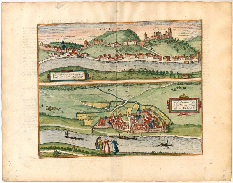
Old, antique map with two bird's-eye views by Braun and Hogenberg: Saarburg and Pfalzel.
Title: Chorographica descriptio Civitatis Sarburgensis [on sheet with] Opp: Palatinum ad Mosellam Flu; vulgo Pfaltz auff der Musell.
Date of the first edition: 1596.
Date of this map: 1596-1640.
Copper engraving, printed on paper.
Size (not including margins): 320 x 440mm (12.6 x 17.32 inches).
Verso: Latin text.
Condition: Original coloured, excellent.
Condition Rating: A+.
From: Civitates Orbis Terrarum, ... Part 5. Köln, 1596-1640.
SAARBURG
CARTOUCHE: Accurate overview of the town of Saarburg.
COMMENTARY BY BRAUN (on verso): "The small town of Saarburg in the archbishopric of Trier, situated on the Saar, is little known amongst chroniclers and hence almost nothing is written about its origins and background. [...] A stone bridge called the Kunz bridge after the neighbouring village crosses the Saar not far from the Moselle. [...] At both ends of the bridge stands a tower in which watch is kept."
The Trier electoral palace and the town around it are seen from Beurig on the right bank of the Saar, today a suburb of Saarburg castle (top right), the later residence of the Trier archbishops, is first mentioned in the 10th century, although the settlement that sprang up beneath it was granted its municipal charter as early as 1291. In the 16th century, the town comprised 100 homes of ordinary citizens (not including those of the nobility or clergy). On the left, the parish church of St Lawrence lies near Saarburg's main attraction, a waterfall, where the Leuk Stream plunges 20 m over rocks. The Kautenturm, on the far left, is a tower that today marks the edge of the Old Town. Saarburg, in the Rhineland-Palatinate, currently has some 6,000 inhabitants.
PFALZEL AN DER MOSEL
CARTOUCHE: The town of Palatinum ad Mosellam, known in German as Pfalzel an der Mosel.
COMMENTARY BY BRAUN (on verso): "Not far from Trier, further down the Moselle on the left bank, lies a small town with a castle called Pfalzel. Its origins are thought to date from the time of King Dagobert in France. In ancient manuscripts and chronicles in the Horrem monastery, at least, it is written that Pfalzel numbered amongst the suburbs of Trier in AD 642, around which time the bishop of Trier furnished this place with a nunnery for noblewomen, whose first abbess was Adela and after whom Pfalzel was subsequently named."
The lower view shows the small town of Pfalzel an der Mosel in what is almost a bird's-eye view. In the centre, the electoral palace of the Trier bishops rises above the surrounding houses. It was erected within the western half of the ruins of the Palatiolum (small imperial palace), a Roman complex probably constructed in the 4th century AD and once thought to have belonged to Caesar. Adela of Pfalzel founded the nunnery of St Mary, which dates back to the 10th century. Visitors today can still admire extensive sections of Pfalzel's unmistakable ramparts with their six original large bastions, of which the Moselle Bastion is the best preserved. (Taschen)
Braun G. & Hogenberg F. and the Civitates Orbis Terrarum.
The Civitates Orbis Terrarum, also known as the 'Braun & Hogenberg', is a six-volume town atlas and the most excellent book of town views and plans ever published: 363 engravings, sometimes beautifully coloured. It was one of the best-selling works in the last quarter of the 16th century. Georg Braun, a skilled writer, wrote the text accompanying the plans and views on the verso. Many plates were engraved after the original drawings of a professional artist, Joris Hoefnagel (1542-1600). The first volume was published in Latin in 1572 and the sixth in 1617. Frans Hogenberg, a talented engraver, created the tables for volumes I through IV, and Simon van den Neuwel made those for volumes V and VI. Other contributors were cartographers Daniel Freese and Heinrich Rantzau, who provided valuable geographical information. Works by Jacob van Deventer, Sebastian Münster, and Johannes Stumpf were also used as references. Translations appeared in German and French, making the atlas accessible to a wider audience.
Since its original publication of volume 1 in 1572, the Civitates Orbis Terrarum has left an indelible mark on the history of cartography. The first volume was followed by seven more editions in 1575, 1577, 1582, 1588, 1593, 1599, and 1612. Vol.2, initially released in 1575, saw subsequent editions in 1597 and 1612. The subsequent volumes, each a treasure trove of historical insights, graced the world in 1581, 1588, 1593, 1599, and 1606. The German translation of the first volume, a testament to its widespread appeal, debuted in 1574, followed by the French edition in 1575.
Several printers were involved: Theodor Graminaeus, Heinrich von Aich, Gottfried von Kempen, Johannis Sinniger, Bertram Buchholtz, and Peter von Brachel, all of whom worked in Cologne.
Georg Braun (1541-1622)
Georg Braun, the author of the text accompanying the plans and views in the Civitates Orbis Terrarum, was born in Cologne in 1541. After his studies in Cologne, he entered the Jesuit Order as a novice, indicating his commitment to learning and intellectual pursuits. In 1561, he obtained his bachelor's degree; in 1562, he received his Magister Artium, further demonstrating his academic achievements. Although he left the Jesuit Order, he continued his studies in theology, gaining a licentiate in theology. His theological background likely influenced the content and tone of the text in the Civitates Orbis Terrarum, adding a unique perspective to the work.
Frans Hogenberg (1535-1590)
Frans Hogenberg was a Flemish and German painter, engraver, and mapmaker. He was born in Mechelen as the son of Nicolaas Hogenberg.
By the end of the 1560s, Frans Hogenberg was employed upon Abraham Ortelius's Theatrum Orbis Terrarum, published in 1570; he is named an engraver of numerous maps. In 1568, he was banned from Antwerp by the Duke of Alva and travelled to London, where he stayed a few years before emigrating to Cologne. He immediately embarked on his two most important works, the Civitates, published in 1572 and the Geschichtsblätter, which appeared in several series from 1569 until about 1587.
Thanks to large-scale projects like the Geschichtsblätter and the Civitates, Hogenberg's social circumstances improved with each passing year. He died as a wealthy man in Cologne in 1590.