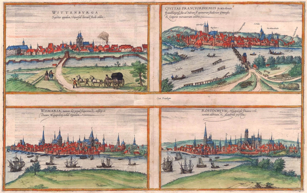
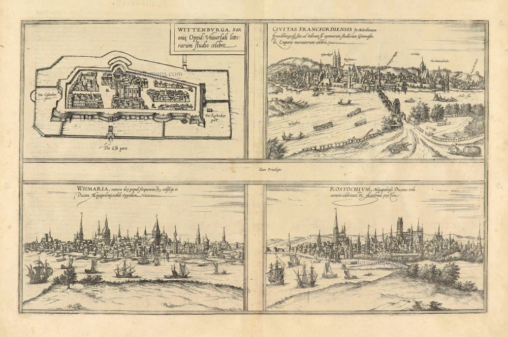
Wittenberg, Frankfurt an der Oder, Wismar and Rostock, by Georg Braun and Frans Hogenberg. 1574
WITTENBERG
CARTOUCHE: Wittenberg, the Saxon town, is universally famous for its cultivation of the sciences.
COMMENTARY BY BRAUN: "Wittenberg, in our day the seat of the Dukes of Saxony, is supposed to take its name, so some people think, from Widukind of Saxony, the first Christian prince of Saxony. In 1502, Elector Frederick III, the son of Ernst, Elector of Saxony, founded a university in this town following the example of Leipzig and Tübingen."
The view of Wittenberg across the Elbe is unspectacular: the single church rising above the town centre, its two massive towers topped by octagonal turrets, is the town church of St Mary, which became the mother church of the Reformation. Wittenberg's palace and palace church are rendered relatively inconspicuous on the far left of the picture. In 1293, Duke Albert II made Wittenberg his residence. 1502 saw the foundation of Leucorea University, where, from 1508 onwards, Martin Luther taught as a professor of biblical exegesis.
FRANKFURT AN DER ODER
CAPTION: The city of Frankfurt an der Oder in the Margraviate of Brandenburg is famous for being a university with the best opportunities for learning and as a centre of commerce.
COMMENTARY BY BRAUN: "Frankfurt is a magnificent city situated in the Brandenburg March; to the east, it lies on the Oder, abounding in fish, and to the west, south and north, it has countless vineyards. The wine they produce is sold via the Oder to Pomerania, Denmark, Prussia and other surrounding lands. A university was founded here in 1506, following the example of Leipzig, which was granted privileges by His Most Serene Highness, Elector Joachim, Pope Alexander VI and Julius II, and also by Emperor Maximilian I."
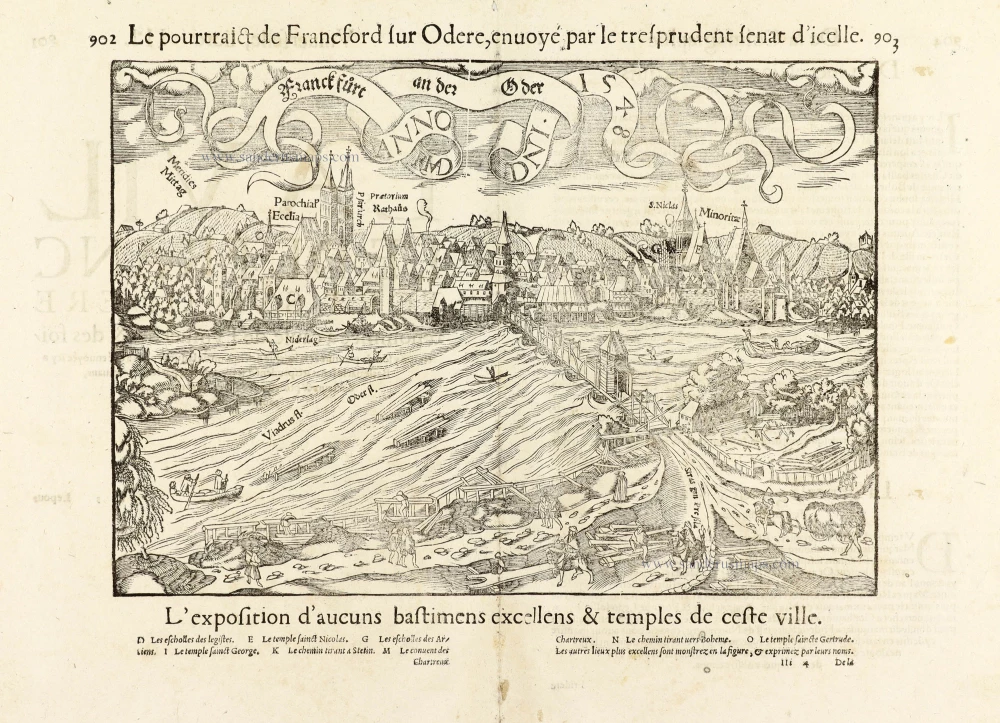
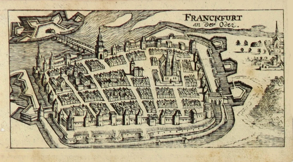
The engraving shows a view of Frankfurt an der Oder as seen from the east. Several boats are plying the river in the foreground. Behind them, the city skyline is hallmarked above all by the towers of the parish churches of St Mary (Pfarrkirch) and St Nicholas, today the Friedenskirche. The city is surrounded by a fortified wall built in the late 13th century, with three gates and some 50 guardhouses and watchtowers. Founded in the 1200s, the settlement rapidly expanded due to its location at the crossroads of Paris, Aachen, Berlin, Warsaw, Moscow, and the Prague-Meissen-Stettin trade routes. In 1253, it was granted its charter and, in 1430, joined the Hansa. The lively river traffic and the road signs pointing to Meissen and Berlin reflect Frankfurt's commercially advantageous location at the intersection of the two trade routes and on the Oder.
ROSTOCK
[The names of Rostock and Wismar have been transposed, and the present plate erroneously identified as Wismar.]
CAPTION: Rostock, a town in the Duchy of Mecklenburg, is distinguished for its famous name and academy.
COMMENTARY BY BRAUN: " The port of Rostock lies on the border of Saxony and belongs to the Duke of Mecklenburg; it was once only a castle surrounded by a few farmhouses, but in 1170 the settlement was fortified, surrounded by an embankment, and grew into a town. It suffered several setbacks due to internal unrest, fires, and other difficulties. It possesses a university founded in 1419 by their Most Serene Highnesses John IV and Albert IV, Princes of Mecklenburg, by the town council, which pays the professors, and with the support of the local inhabitants."
WISMAR
[The names of Rostock and Wismar have been transposed, and the present plate erroneously identified as Rostock.]
CAPTION: Wismar, a town in the Duchy of Mecklenburg known for its location, large population, and buildings.
COMMENTARY BY BRAUN: "A piteous event took place in this city: a carpenter, who sometimes lost his wits and fell into a rage, e.g. while working, took an axe, ran home and with a terrible bellow cleaved his own children in half and also cut down their pregnant mother, so that he murdered two at one stroke. Dear God, is it possible to imagine anything more dreadful than this murder?"
Interestingly, this is the first time that Braun recounts a tale of horror of the kind frequently found in the earlier city chronicles of Hartmann Schedel and Sebastian Munster. These stories were published in the Newen Zeytungen broadsheets that were the forerunners of today's newspapers. (Taschen)
Braun G. & Hogenberg F. and the Civitates Orbis Terrarum.
The Civitates Orbis Terrarum, also known as the 'Braun & Hogenberg', is a six-volume town atlas and the most excellent book of town views and plans ever published: 363 engravings, sometimes beautifully coloured. It was one of the best-selling works in the last quarter of the 16th century. Georg Braun, a skilled writer, wrote the text accompanying the plans and views on the verso. Many plates were engraved after the original drawings of a professional artist, Joris Hoefnagel (1542-1600). The first volume was published in Latin in 1572 and the sixth in 1617. Frans Hogenberg, a talented engraver, created the tables for volumes I through IV, and Simon van den Neuwel made those for volumes V and VI. Other contributors were cartographers Daniel Freese and Heinrich Rantzau, who provided valuable geographical information. Works by Jacob van Deventer, Sebastian Münster, and Johannes Stumpf were also used as references. Translations appeared in German and French, making the atlas accessible to a broader audience.
Since its original publication of volume 1 in 1572, the Civitates Orbis Terrarum has left an indelible mark on the history of cartography. Seven more editions followed the first volume in 1575, 1577, 1582, 1588, 1593, 1599, and 1612. Vol.2, initially released in 1575, saw subsequent editions in 1597 and 1612. The subsequent volumes, each a treasure trove of historical insights, graced the world in 1581, 1588, 1593, 1599, and 1606. The German translation of the first volume, a testament to its widespread appeal, debuted in 1574, followed by the French edition in 1575.
Several printers were involved: Theodor Graminaeus, Heinrich von Aich, Gottfried von Kempen, Johannis Sinniger, Bertram Buchholtz, and Peter von Brachel, all of whom worked in Cologne.
Georg Braun (1541-1622)
Georg Braun, the author of the text accompanying the plans and views in the Civitates Orbis Terrarum, was born in Cologne in 1541. After his studies in Cologne, he entered the Jesuit Order as a novice, indicating his commitment to learning and intellectual pursuits. In 1561, he obtained his bachelor's degree; in 1562, he received his Magister Artium, further demonstrating his academic achievements. Although he left the Jesuit Order, he continued his studies in theology, gaining a licentiate in theology. His theological background likely influenced the content and tone of the text in the Civitates Orbis Terrarum, adding a unique perspective to the work.
Frans Hogenberg (1535-1590)
Frans Hogenberg was a Flemish and German painter, engraver, and mapmaker. He was born in Mechelen as the son of Nicolaas Hogenberg.
By the end of the 1560s, Frans Hogenberg was employed upon Abraham Ortelius's Theatrum Orbis Terrarum, published in 1570; he is named an engraver of numerous maps. In 1568, he was banned from Antwerp by the Duke of Alva and travelled to London, where he stayed a few years before emigrating to Cologne. He immediately embarked on his two most important works, the Civitates, published in 1572 and the Geschichtsblätter, which appeared in several series from 1569 until about 1587.
Thanks to large-scale projects like the Geschichtsblätter and the Civitates, Hogenberg's social circumstances improved with each passing year. He died as a wealthy man in Cologne in 1590.
Wittenburga Saxoniae oppidum, ... [on sheet with] Civitas Francfordiensis In Marchionatu Brandeburgensi, ... [and] Wismaria, ... [and] Rostochium, ...
Item Number: 5380 Authenticity Guarantee
Category: Antique maps > Europe > Germany - Cities
Old, antique bird’s-eye view of Wittenberg - Frankfurt an der Oder - Weimar - Rostock, by Georg Braun & Frans Hogenberg.
Title: Wittenburga Saxoniae oppidum, ... [on sheet with] Civitas Francfordiensis In Marchionatu Brandeburgensi, ... [and] Wismaria, ... [and] Rostochium, ...
Date of the first edition: 1572.
Date of this map: 1574.
Copper engraving, printed on paper.
Size (not including margins): 305 x 480mm (12.01 x 18.9 inches).
Verso: German text.
Condition: Old coloured.
Condition Rating: .
From: Beschreibung und Contrafactur der Vornembster Stät der Welt. Köln, Heinrich von Ach, 1574. (Van der Krogt 4, 41:2.1)
WITTENBERG
CARTOUCHE: Wittenberg, the Saxon town, is universally famous for its cultivation of the sciences.
COMMENTARY BY BRAUN: "Wittenberg, in our day the seat of the Dukes of Saxony, is supposed to take its name, so some people think, from Widukind of Saxony, the first Christian prince of Saxony. In 1502, Elector Frederick III, the son of Ernst, Elector of Saxony, founded a university in this town following the example of Leipzig and Tübingen."
The view of Wittenberg across the Elbe is unspectacular: the single church rising above the town centre, its two massive towers topped by octagonal turrets, is the town church of St Mary, which became the mother church of the Reformation. Wittenberg's palace and palace church are rendered relatively inconspicuous on the far left of the picture. In 1293, Duke Albert II made Wittenberg his residence. 1502 saw the foundation of Leucorea University, where, from 1508 onwards, Martin Luther taught as a professor of biblical exegesis.
FRANKFURT AN DER ODER
CAPTION: The city of Frankfurt an der Oder in the Margraviate of Brandenburg is famous for being a university with the best opportunities for learning and as a centre of commerce.
COMMENTARY BY BRAUN: "Frankfurt is a magnificent city situated in the Brandenburg March; to the east, it lies on the Oder, abounding in fish, and to the west, south and north, it has countless vineyards. The wine they produce is sold via the Oder to Pomerania, Denmark, Prussia and other surrounding lands. A university was founded here in 1506, following the example of Leipzig, which was granted privileges by His Most Serene Highness, Elector Joachim, Pope Alexander VI and Julius II, and also by Emperor Maximilian I."
The engraving shows a view of Frankfurt an der Oder as seen from the east. Several boats are plying the river in the foreground. Behind them, the city skyline is hallmarked above all by the towers of the parish churches of St Mary (Pfarrkirch) and St Nicholas, today the Friedenskirche. The city is surrounded by a fortified wall built in the late 13th century, with three gates and some 50 guardhouses and watchtowers. Founded in the 1200s, the settlement rapidly expanded due to its location at the crossroads of Paris, Aachen, Berlin, Warsaw, Moscow, and the Prague-Meissen-Stettin trade routes. In 1253, it was granted its charter and, in 1430, joined the Hansa. The lively river traffic and the road signs pointing to Meissen and Berlin reflect Frankfurt's commercially advantageous location at the intersection of the two trade routes and on the Oder.
ROSTOCK
[The names of Rostock and Wismar have been transposed, and the present plate erroneously identified as Wismar.]
CAPTION: Rostock, a town in the Duchy of Mecklenburg, is distinguished for its famous name and academy.
COMMENTARY BY BRAUN: " The port of Rostock lies on the border of Saxony and belongs to the Duke of Mecklenburg; it was once only a castle surrounded by a few farmhouses, but in 1170 the settlement was fortified, surrounded by an embankment, and grew into a town. It suffered several setbacks due to internal unrest, fires, and other difficulties. It possesses a university founded in 1419 by their Most Serene Highnesses John IV and Albert IV, Princes of Mecklenburg, by the town council, which pays the professors, and with the support of the local inhabitants."
WISMAR
[The names of Rostock and Wismar have been transposed, and the present plate erroneously identified as Rostock.]
CAPTION: Wismar, a town in the Duchy of Mecklenburg known for its location, large population, and buildings.
COMMENTARY BY BRAUN: "A piteous event took place in this city: a carpenter, who sometimes lost his wits and fell into a rage, e.g. while working, took an axe, ran home and with a terrible bellow cleaved his own children in half and also cut down their pregnant mother, so that he murdered two at one stroke. Dear God, is it possible to imagine anything more dreadful than this murder?"
Interestingly, this is the first time that Braun recounts a tale of horror of the kind frequently found in the earlier city chronicles of Hartmann Schedel and Sebastian Munster. These stories were published in the Newen Zeytungen broadsheets that were the forerunners of today's newspapers. (Taschen)
Braun G. & Hogenberg F. and the Civitates Orbis Terrarum.
The Civitates Orbis Terrarum, also known as the 'Braun & Hogenberg', is a six-volume town atlas and the most excellent book of town views and plans ever published: 363 engravings, sometimes beautifully coloured. It was one of the best-selling works in the last quarter of the 16th century. Georg Braun, a skilled writer, wrote the text accompanying the plans and views on the verso. Many plates were engraved after the original drawings of a professional artist, Joris Hoefnagel (1542-1600). The first volume was published in Latin in 1572 and the sixth in 1617. Frans Hogenberg, a talented engraver, created the tables for volumes I through IV, and Simon van den Neuwel made those for volumes V and VI. Other contributors were cartographers Daniel Freese and Heinrich Rantzau, who provided valuable geographical information. Works by Jacob van Deventer, Sebastian Münster, and Johannes Stumpf were also used as references. Translations appeared in German and French, making the atlas accessible to a broader audience.
Since its original publication of volume 1 in 1572, the Civitates Orbis Terrarum has left an indelible mark on the history of cartography. Seven more editions followed the first volume in 1575, 1577, 1582, 1588, 1593, 1599, and 1612. Vol.2, initially released in 1575, saw subsequent editions in 1597 and 1612. The subsequent volumes, each a treasure trove of historical insights, graced the world in 1581, 1588, 1593, 1599, and 1606. The German translation of the first volume, a testament to its widespread appeal, debuted in 1574, followed by the French edition in 1575.
Several printers were involved: Theodor Graminaeus, Heinrich von Aich, Gottfried von Kempen, Johannis Sinniger, Bertram Buchholtz, and Peter von Brachel, all of whom worked in Cologne.
Georg Braun (1541-1622)
Georg Braun, the author of the text accompanying the plans and views in the Civitates Orbis Terrarum, was born in Cologne in 1541. After his studies in Cologne, he entered the Jesuit Order as a novice, indicating his commitment to learning and intellectual pursuits. In 1561, he obtained his bachelor's degree; in 1562, he received his Magister Artium, further demonstrating his academic achievements. Although he left the Jesuit Order, he continued his studies in theology, gaining a licentiate in theology. His theological background likely influenced the content and tone of the text in the Civitates Orbis Terrarum, adding a unique perspective to the work.
Frans Hogenberg (1535-1590)
Frans Hogenberg was a Flemish and German painter, engraver, and mapmaker. He was born in Mechelen as the son of Nicolaas Hogenberg.
By the end of the 1560s, Frans Hogenberg was employed upon Abraham Ortelius's Theatrum Orbis Terrarum, published in 1570; he is named an engraver of numerous maps. In 1568, he was banned from Antwerp by the Duke of Alva and travelled to London, where he stayed a few years before emigrating to Cologne. He immediately embarked on his two most important works, the Civitates, published in 1572 and the Geschichtsblätter, which appeared in several series from 1569 until about 1587.
Thanks to large-scale projects like the Geschichtsblätter and the Civitates, Hogenberg's social circumstances improved with each passing year. He died as a wealthy man in Cologne in 1590.

