
München, Ingolstadt, Freissing, Nördlingen, Regensburg and Straubing, by Georg Braun and Frans Hogenberg. 1577
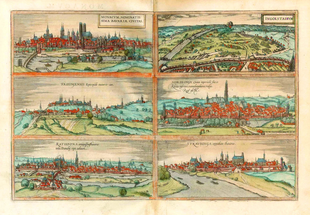


MUNICH (MÜNCHEN)
TRANSLATION OF CARTOUCHE TEXT: Munich, the most frequently mentioned city in Bavaria.
COMMENTARY BY BRAUN: "Munich is a splendid city in Bavaria, situated on the Isar. It has a favourable location and possesses a magnificent palace, in which the Bavarian princes hold court in our own day."
The view of Munich across the banks of the Isar is the first of six small-format views of Upper German cities presented on a double page. The Dom Zu Unserer Lieben Frau, the so-called Frauenkirche, with its characteristic bulbous domes dating from 1525, can be identified at the centre.
INGOLSTADT
COMMENTARY BY BRAUN: "In the beginning Ingolstadt was not exactly a large town, almost rectangular in shape, and within an area marked by the three ancient towers that still stand today: the Glockenturm in the cemetry of the minster of Our Lady, the Striegelturm beside the gaol and the Judenturm. The old castle is also a clear indication of this. Ingolstadt was first expanded in 1312, when it grew to about double the size and took on a shape resembling that of an egg, apart from a few bulges in the southern part of the town."
Braun's text bears no relation to the plate: it shows a small part of Ingolstadt from an unusual perspective, looking from the church tower (visible on the right) across the fortified city wall at an animated battle field. In 1537 Ingolstadt was made into a Bavarian fortress through the construction of a new wall with bastions. In 1546, during the Schmalkaldic War, the troops of Charles V fought those of the Schmalkaldic League before the gates of the city.
This view appears in only a few editions of the Civitates ; at this place in the first edition there is just an empty space to the right of Munich, in later editions there is a very schematic view of Innsbruck.
FREISING
CAPTION: Picture of the episcopal city of Freising.
COMMENTARY BY BRAUN: "Freising, the episcopal city in Bavaria, [...] is said to have been founded at the time of Roman rule, which extended from the Danube to the Alps, on a favourable site by the Moosach, which flows into the Isar close by. Beatus Rhenanus records that in the library of St Corbinian's he found a very beautiful book containing the four Gospels in Frankish."
The cityscape of Freising remains hallmarked even today by the Domberg hill with the cathedral of SS Mary and Corbinian. The red-brick basilica arose in the 12th century on the ruins of an earlier church dedicated to St Mary dating from the 8th century. In the 17th/18th centuries it was remodelled in the Baroque style. As Braun notes in his text, in 1531 the German humanist and philologist Beatus Rhenanus discovered in the cathedral's important library the Gospel Harmony of Otfried von Weissenburg, dating from the 9th century, a very early example of Old High German (Frankish) poetry.
NÖRDLINGEN
CAPTION: Nördlingen, imperial city in Lower Rhaetia, on the far side of the Danube, commonly called Ries.
COMMENTARY BY BRAUN: "Nördlingen formerly lay on the Hohe Hart hill, above the present city, where the old parish church of St Emmeran can still be seen. This town burned down in 1238 and due to the lack of water many lost their lives. Afterwards it was rebuilt in the valley beside the Eger, and ever since then the waters of the river have run through it."
Nördlingen is seen in side view from the northwest. The historical cityscape has survived right up to the present and is hallmarked by the late medieval city wall from the 14th century, which boasts five tower gates and 16 further turrets. The tower rising almost 90m high in the centre is known as "The Daniel" and forms part of the late Gothic parish church of St George. In front of it lies the town hall of 1382. Nördlingen was an imperial city from 1215 to 1803. In 1529 it signed the Protestant Confession at the imperial diet in Speyer and embraced the Reformation.
REGENSBURG
CAPTION: Regensburg, the oldest city in Bavaria, lies on the Danube.
COMMENTARY BY BRAUN: "Regensburg is a magnificent and ancient city in Bavaria on the banks of the Danube, at a favourably situated point where four rivers converge. For the Laber and the Naab flow into the Danube above the city and the Regen below it. [...] Emperor Arnulf expanded the city and most importantly linked it to the settlement on the opposite bank by means of a sturdy stone bridge with many arches."
This plate offers a view across the suburb of Stadt am Hof and the stone bridge with its three towers towards the Gothic cathedral. As well as church steeples, the numerous family towers belonging to wealthy patrician houses are visible on the skyline. The highest tower is that of the town hall.
STRAUBING
COMMENTARY BY BRAUN: "Straubing is a town in Bavaria that was founded by Duke Ludwig in 1218. The Danube runs near the town and thereby lends it importance."
Straubing is shown from the northeast looking across the Danube. The town's present-day cityscape bears a close resemblance to that in the early modern era and is dominated by the 68-m-high Gothic watchtower and the 14th-century town hall beside it. Also clearly recognizable are the largest church in the town, St James's, to the left of which is the Romanesque church of St Peter and on the right the Gothic red-brick church of St Veit. Straubing, which received its charter in 1218, was initially a centre of the Reformation in Lower Bavaria, but in the Counter-Reformation the Protestants were expelled from the town. (Taschen)
Braun G. & Hogenberg F. and the Civitates Orbis Terrarum.
The Civitates Orbis Terrarum, also known as the 'Braun & Hogenberg', is a six-volume town atlas and the most excellent book of town views and plans ever published: 363 engravings, sometimes beautifully coloured. It was one of the best-selling works in the last quarter of the 16th century. Georg Braun, a skilled writer, wrote the text accompanying the plans and views on the verso. Many plates were engraved after the original drawings of a professional artist, Joris Hoefnagel (1542-1600). The first volume was published in Latin in 1572 and the sixth in 1617. Frans Hogenberg, a talented engraver, created the tables for volumes I through IV, and Simon van den Neuwel made those for volumes V and VI. Other contributors were cartographers Daniel Freese and Heinrich Rantzau, who provided valuable geographical information. Works by Jacob van Deventer, Sebastian Münster, and Johannes Stumpf were also used as references. Translations appeared in German and French, making the atlas accessible to a broader audience.
Since its original publication of volume 1 in 1572, the Civitates Orbis Terrarum has left an indelible mark on the history of cartography. Seven more editions followed the first volume in 1575, 1577, 1582, 1588, 1593, 1599, and 1612. Vol.2, initially released in 1575, saw subsequent editions in 1597 and 1612. The subsequent volumes, each a treasure trove of historical insights, graced the world in 1581, 1588, 1593, 1599, and 1606. The German translation of the first volume, a testament to its widespread appeal, debuted in 1574, followed by the French edition in 1575.
Several printers were involved: Theodor Graminaeus, Heinrich von Aich, Gottfried von Kempen, Johannis Sinniger, Bertram Buchholtz, and Peter von Brachel, all of whom worked in Cologne.
Georg Braun (1541-1622)
Georg Braun, the author of the text accompanying the plans and views in the Civitates Orbis Terrarum, was born in Cologne in 1541. After his studies in Cologne, he entered the Jesuit Order as a novice, indicating his commitment to learning and intellectual pursuits. In 1561, he obtained his bachelor's degree; in 1562, he received his Magister Artium, further demonstrating his academic achievements. Although he left the Jesuit Order, he continued his studies in theology, gaining a licentiate in theology. His theological background likely influenced the content and tone of the text in the Civitates Orbis Terrarum, adding a unique perspective to the work.
Frans Hogenberg (1535-1590)
Frans Hogenberg was a Flemish and German painter, engraver, and mapmaker. He was born in Mechelen as the son of Nicolaas Hogenberg.
By the end of the 1560s, Frans Hogenberg was employed upon Abraham Ortelius's Theatrum Orbis Terrarum, published in 1570; he is named an engraver of numerous maps. In 1568, he was banned from Antwerp by the Duke of Alva and travelled to London, where he stayed a few years before emigrating to Cologne. He immediately embarked on his two most important works, the Civitates, published in 1572 and the Geschichtsblätter, which appeared in several series from 1569 until about 1587.
Thanks to large-scale projects like the Geschichtsblätter and the Civitates, Hogenberg's social circumstances improved with each passing year. He died as a wealthy man in Cologne in 1590.
Monacum, nominatis sima Bavariae, Civitas [on sheet with] Ingolstadium [and] Frisingensis ... [and] Nordlinga ... [and] Ratispona ... [and] Straubinga ...
Item Number: 26679 Authenticity Guarantee
Category: Antique maps > Europe > Germany - Cities
Old, antique map with six German bird's-eye views by Georg Braun and Franz Hogenberg: München, Ingolstadt, Freissing, Nördlingen, Regensburg and Straubing.
MUNICH (MÜNCHEN)
TRANSLATION OF CARTOUCHE TEXT: Munich, the most frequently mentioned city in Bavaria.
COMMENTARY BY BRAUN: "Munich is a splendid city in Bavaria, situated on the Isar. It has a favourable location and possesses a magnificent palace, in which the Bavarian princes hold court in our own day."
The view of Munich across the banks of the Isar is the first of six small-format views of Upper German cities presented on a double page. The Dom Zu Unserer Lieben Frau, the so-called Frauenkirche, with its characteristic bulbous domes dating from 1525, can be identified at the centre.
INGOLSTADT
COMMENTARY BY BRAUN: "In the beginning Ingolstadt was not exactly a large town, almost rectangular in shape, and within an area marked by the three ancient towers that still stand today: the Glockenturm in the cemetry of the minster of Our Lady, the Striegelturm beside the gaol and the Judenturm. The old castle is also a clear indication of this. Ingolstadt was first expanded in 1312, when it grew to about double the size and took on a shape resembling that of an egg, apart from a few bulges in the southern part of the town."
Braun's text bears no relation to the plate: it shows a small part of Ingolstadt from an unusual perspective, looking from the church tower (visible on the right) across the fortified city wall at an animated battle field. In 1537 Ingolstadt was made into a Bavarian fortress through the construction of a new wall with bastions. In 1546, during the Schmalkaldic War, the troops of Charles V fought those of the Schmalkaldic League before the gates of the city.
This view appears in only a few editions of the Civitates ; at this place in the first edition there is just an empty space to the right of Munich, in later editions there is a very schematic view of Innsbruck.
FREISING
CAPTION: Picture of the episcopal city of Freising.
COMMENTARY BY BRAUN: "Freising, the episcopal city in Bavaria, [...] is said to have been founded at the time of Roman rule, which extended from the Danube to the Alps, on a favourable site by the Moosach, which flows into the Isar close by. Beatus Rhenanus records that in the library of St Corbinian's he found a very beautiful book containing the four Gospels in Frankish."
The cityscape of Freising remains hallmarked even today by the Domberg hill with the cathedral of SS Mary and Corbinian. The red-brick basilica arose in the 12th century on the ruins of an earlier church dedicated to St Mary dating from the 8th century. In the 17th/18th centuries it was remodelled in the Baroque style. As Braun notes in his text, in 1531 the German humanist and philologist Beatus Rhenanus discovered in the cathedral's important library the Gospel Harmony of Otfried von Weissenburg, dating from the 9th century, a very early example of Old High German (Frankish) poetry.
NÖRDLINGEN
CAPTION: Nördlingen, imperial city in Lower Rhaetia, on the far side of the Danube, commonly called Ries.
COMMENTARY BY BRAUN: "Nördlingen formerly lay on the Hohe Hart hill, above the present city, where the old parish church of St Emmeran can still be seen. This town burned down in 1238 and due to the lack of water many lost their lives. Afterwards it was rebuilt in the valley beside the Eger, and ever since then the waters of the river have run through it."
Nördlingen is seen in side view from the northwest. The historical cityscape has survived right up to the present and is hallmarked by the late medieval city wall from the 14th century, which boasts five tower gates and 16 further turrets. The tower rising almost 90m high in the centre is known as "The Daniel" and forms part of the late Gothic parish church of St George. In front of it lies the town hall of 1382. Nördlingen was an imperial city from 1215 to 1803. In 1529 it signed the Protestant Confession at the imperial diet in Speyer and embraced the Reformation.
REGENSBURG
CAPTION: Regensburg, the oldest city in Bavaria, lies on the Danube.
COMMENTARY BY BRAUN: "Regensburg is a magnificent and ancient city in Bavaria on the banks of the Danube, at a favourably situated point where four rivers converge. For the Laber and the Naab flow into the Danube above the city and the Regen below it. [...] Emperor Arnulf expanded the city and most importantly linked it to the settlement on the opposite bank by means of a sturdy stone bridge with many arches."
This plate offers a view across the suburb of Stadt am Hof and the stone bridge with its three towers towards the Gothic cathedral. As well as church steeples, the numerous family towers belonging to wealthy patrician houses are visible on the skyline. The highest tower is that of the town hall.
STRAUBING
COMMENTARY BY BRAUN: "Straubing is a town in Bavaria that was founded by Duke Ludwig in 1218. The Danube runs near the town and thereby lends it importance."
Straubing is shown from the northeast looking across the Danube. The town's present-day cityscape bears a close resemblance to that in the early modern era and is dominated by the 68-m-high Gothic watchtower and the 14th-century town hall beside it. Also clearly recognizable are the largest church in the town, St James's, to the left of which is the Romanesque church of St Peter and on the right the Gothic red-brick church of St Veit. Straubing, which received its charter in 1218, was initially a centre of the Reformation in Lower Bavaria, but in the Counter-Reformation the Protestants were expelled from the town. (Taschen)
Date of the first edition: 1572
Date of this map: 1577
Copper engraving, printed on paper.
Size (not including margins): 31 x 46.5cm (12.1 x 18.1 inches)
Verso text: Latin
Condition: Original coloured, excellent.
Condition Rating: A
References: Van der Krogt 4, 2893 State.4; Fauser, 9252; Taschen, Braun and Hogenberg, p.106-107.
From: Civitates Orbis Terrarum, Liber Primus. Köln, Gottfried von Kempen, 1577. (Van der Krogt 4, 41:1.1)
MUNICH (MÜNCHEN)
TRANSLATION OF CARTOUCHE TEXT: Munich, the most frequently mentioned city in Bavaria.
COMMENTARY BY BRAUN: "Munich is a splendid city in Bavaria, situated on the Isar. It has a favourable location and possesses a magnificent palace, in which the Bavarian princes hold court in our own day."
The view of Munich across the banks of the Isar is the first of six small-format views of Upper German cities presented on a double page. The Dom Zu Unserer Lieben Frau, the so-called Frauenkirche, with its characteristic bulbous domes dating from 1525, can be identified at the centre.
INGOLSTADT
COMMENTARY BY BRAUN: "In the beginning Ingolstadt was not exactly a large town, almost rectangular in shape, and within an area marked by the three ancient towers that still stand today: the Glockenturm in the cemetry of the minster of Our Lady, the Striegelturm beside the gaol and the Judenturm. The old castle is also a clear indication of this. Ingolstadt was first expanded in 1312, when it grew to about double the size and took on a shape resembling that of an egg, apart from a few bulges in the southern part of the town."
Braun's text bears no relation to the plate: it shows a small part of Ingolstadt from an unusual perspective, looking from the church tower (visible on the right) across the fortified city wall at an animated battle field. In 1537 Ingolstadt was made into a Bavarian fortress through the construction of a new wall with bastions. In 1546, during the Schmalkaldic War, the troops of Charles V fought those of the Schmalkaldic League before the gates of the city.
This view appears in only a few editions of the Civitates ; at this place in the first edition there is just an empty space to the right of Munich, in later editions there is a very schematic view of Innsbruck.
FREISING
CAPTION: Picture of the episcopal city of Freising.
COMMENTARY BY BRAUN: "Freising, the episcopal city in Bavaria, [...] is said to have been founded at the time of Roman rule, which extended from the Danube to the Alps, on a favourable site by the Moosach, which flows into the Isar close by. Beatus Rhenanus records that in the library of St Corbinian's he found a very beautiful book containing the four Gospels in Frankish."
The cityscape of Freising remains hallmarked even today by the Domberg hill with the cathedral of SS Mary and Corbinian. The red-brick basilica arose in the 12th century on the ruins of an earlier church dedicated to St Mary dating from the 8th century. In the 17th/18th centuries it was remodelled in the Baroque style. As Braun notes in his text, in 1531 the German humanist and philologist Beatus Rhenanus discovered in the cathedral's important library the Gospel Harmony of Otfried von Weissenburg, dating from the 9th century, a very early example of Old High German (Frankish) poetry.
NÖRDLINGEN
CAPTION: Nördlingen, imperial city in Lower Rhaetia, on the far side of the Danube, commonly called Ries.
COMMENTARY BY BRAUN: "Nördlingen formerly lay on the Hohe Hart hill, above the present city, where the old parish church of St Emmeran can still be seen. This town burned down in 1238 and due to the lack of water many lost their lives. Afterwards it was rebuilt in the valley beside the Eger, and ever since then the waters of the river have run through it."
Nördlingen is seen in side view from the northwest. The historical cityscape has survived right up to the present and is hallmarked by the late medieval city wall from the 14th century, which boasts five tower gates and 16 further turrets. The tower rising almost 90m high in the centre is known as "The Daniel" and forms part of the late Gothic parish church of St George. In front of it lies the town hall of 1382. Nördlingen was an imperial city from 1215 to 1803. In 1529 it signed the Protestant Confession at the imperial diet in Speyer and embraced the Reformation.
REGENSBURG
CAPTION: Regensburg, the oldest city in Bavaria, lies on the Danube.
COMMENTARY BY BRAUN: "Regensburg is a magnificent and ancient city in Bavaria on the banks of the Danube, at a favourably situated point where four rivers converge. For the Laber and the Naab flow into the Danube above the city and the Regen below it. [...] Emperor Arnulf expanded the city and most importantly linked it to the settlement on the opposite bank by means of a sturdy stone bridge with many arches."
This plate offers a view across the suburb of Stadt am Hof and the stone bridge with its three towers towards the Gothic cathedral. As well as church steeples, the numerous family towers belonging to wealthy patrician houses are visible on the skyline. The highest tower is that of the town hall.
STRAUBING
COMMENTARY BY BRAUN: "Straubing is a town in Bavaria that was founded by Duke Ludwig in 1218. The Danube runs near the town and thereby lends it importance."
Straubing is shown from the northeast looking across the Danube. The town's present-day cityscape bears a close resemblance to that in the early modern era and is dominated by the 68-m-high Gothic watchtower and the 14th-century town hall beside it. Also clearly recognizable are the largest church in the town, St James's, to the left of which is the Romanesque church of St Peter and on the right the Gothic red-brick church of St Veit. Straubing, which received its charter in 1218, was initially a centre of the Reformation in Lower Bavaria, but in the Counter-Reformation the Protestants were expelled from the town. (Taschen)
Braun G. & Hogenberg F. and the Civitates Orbis Terrarum.
The Civitates Orbis Terrarum, also known as the 'Braun & Hogenberg', is a six-volume town atlas and the most excellent book of town views and plans ever published: 363 engravings, sometimes beautifully coloured. It was one of the best-selling works in the last quarter of the 16th century. Georg Braun, a skilled writer, wrote the text accompanying the plans and views on the verso. Many plates were engraved after the original drawings of a professional artist, Joris Hoefnagel (1542-1600). The first volume was published in Latin in 1572 and the sixth in 1617. Frans Hogenberg, a talented engraver, created the tables for volumes I through IV, and Simon van den Neuwel made those for volumes V and VI. Other contributors were cartographers Daniel Freese and Heinrich Rantzau, who provided valuable geographical information. Works by Jacob van Deventer, Sebastian Münster, and Johannes Stumpf were also used as references. Translations appeared in German and French, making the atlas accessible to a broader audience.
Since its original publication of volume 1 in 1572, the Civitates Orbis Terrarum has left an indelible mark on the history of cartography. Seven more editions followed the first volume in 1575, 1577, 1582, 1588, 1593, 1599, and 1612. Vol.2, initially released in 1575, saw subsequent editions in 1597 and 1612. The subsequent volumes, each a treasure trove of historical insights, graced the world in 1581, 1588, 1593, 1599, and 1606. The German translation of the first volume, a testament to its widespread appeal, debuted in 1574, followed by the French edition in 1575.
Several printers were involved: Theodor Graminaeus, Heinrich von Aich, Gottfried von Kempen, Johannis Sinniger, Bertram Buchholtz, and Peter von Brachel, all of whom worked in Cologne.
Georg Braun (1541-1622)
Georg Braun, the author of the text accompanying the plans and views in the Civitates Orbis Terrarum, was born in Cologne in 1541. After his studies in Cologne, he entered the Jesuit Order as a novice, indicating his commitment to learning and intellectual pursuits. In 1561, he obtained his bachelor's degree; in 1562, he received his Magister Artium, further demonstrating his academic achievements. Although he left the Jesuit Order, he continued his studies in theology, gaining a licentiate in theology. His theological background likely influenced the content and tone of the text in the Civitates Orbis Terrarum, adding a unique perspective to the work.
Frans Hogenberg (1535-1590)
Frans Hogenberg was a Flemish and German painter, engraver, and mapmaker. He was born in Mechelen as the son of Nicolaas Hogenberg.
By the end of the 1560s, Frans Hogenberg was employed upon Abraham Ortelius's Theatrum Orbis Terrarum, published in 1570; he is named an engraver of numerous maps. In 1568, he was banned from Antwerp by the Duke of Alva and travelled to London, where he stayed a few years before emigrating to Cologne. He immediately embarked on his two most important works, the Civitates, published in 1572 and the Geschichtsblätter, which appeared in several series from 1569 until about 1587.
Thanks to large-scale projects like the Geschichtsblätter and the Civitates, Hogenberg's social circumstances improved with each passing year. He died as a wealthy man in Cologne in 1590.
Related items

Ingolstatt 1720
Ingolstadt, by Bodenehr G.
[Item number: 13357]

Ratisbona. 1493
Regensburg, by H. Schedel.
[Item number: 26582]
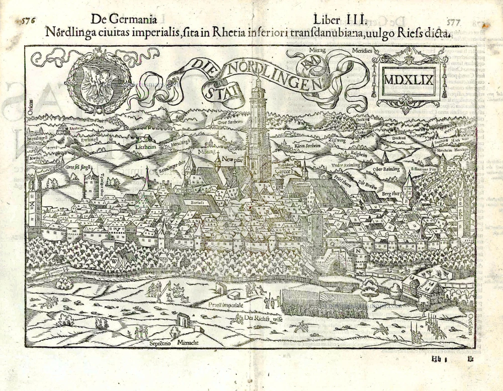
Die Stat Nördlingen. - MDXLIX - Nördlinga civitas imperialis sita in Rhaetia inferiori ... 1552
Nördlingen, by Sebastian Münster.
[Item number: 26862]

Monacum, nominatis sima Bavariae, Civitas. [on sheet with] Ingolstadium. [and] Frisingensis Episcopalis civitatis icon. [and] Nordlinga Civitas imperialis sita in Rhetia inferioris transdanubiana, vulgo Rieß dicta. [and] Ratispona antiquissima Bavariae urbs, Danubij ripis adiacet. [and] Straubinga oppidum Bavariae. 1574
München, Ingolstadt, Freising, Nördlingen, Regensburg and Straubing, by Georg Braun & Frans Hogenberg.
[Item number: 28041]
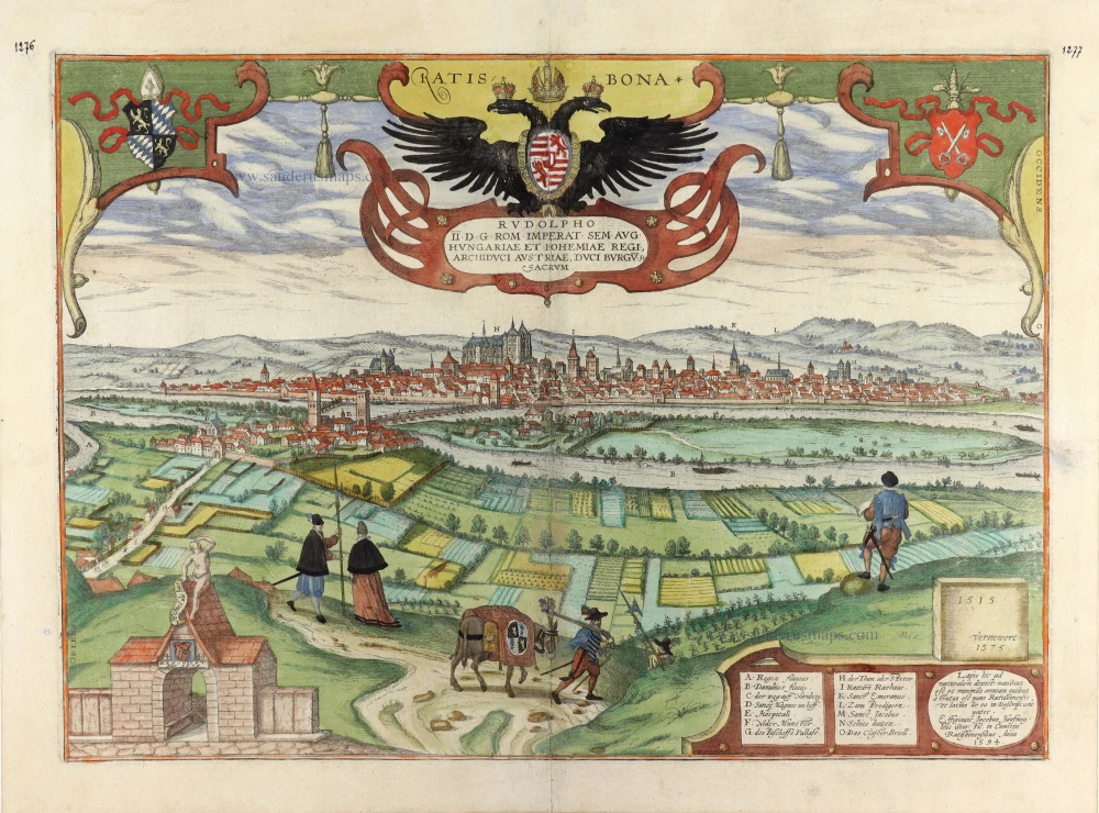
Ratisbona. c. 1610
Regensburg by Georg Braun & Frans Hogenberg.
[Item number: 29953]

First edition
Monachium Utriusque Bavariae Civitas Primar. 1588
Panoramic view of Munich (München), by Braun and Hogenberg, after Georg Hoefnagel.
[Item number: 30926]