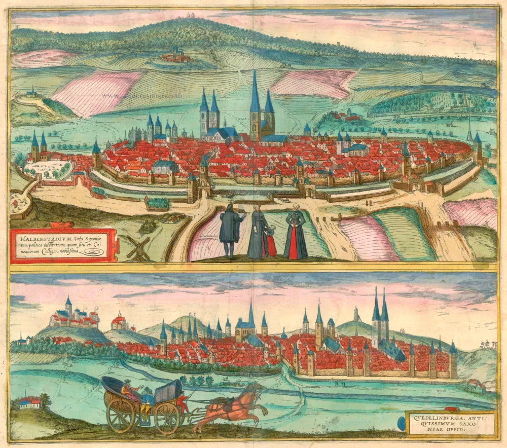
Halberstadt and Quedlinburg, by Georg Braun and Frans Hogenberg. 1581-88


Braun G. & Hogenberg F. and the Civitates Orbis Terrarum.
The Civitates Orbis Terrarum, also known as the 'Braun & Hogenberg', is a six-volume town atlas and the most excellent book of town views and plans ever published: 363 engravings, sometimes beautifully coloured. It was one of the best-selling works in the last quarter of the 16th century. Georg Braun, a skilled writer, wrote the text accompanying the plans and views on the verso. Many plates were engraved after the original drawings of a professional artist, Joris Hoefnagel (1542-1600). The first volume was published in Latin in 1572 and the sixth in 1617. Frans Hogenberg, a talented engraver, created the tables for volumes I through IV, and Simon van den Neuwel made those for volumes V and VI. Other contributors were cartographers Daniel Freese and Heinrich Rantzau, who provided valuable geographical information. Works by Jacob van Deventer, Sebastian Münster, and Johannes Stumpf were also used as references. Translations appeared in German and French, making the atlas accessible to a wider audience.
Since its original publication of volume 1 in 1572, the Civitates Orbis Terrarum has left an indelible mark on the history of cartography. The first volume was followed by seven more editions in 1575, 1577, 1582, 1588, 1593, 1599, and 1612. Vol.2, initially released in 1575, saw subsequent editions in 1597 and 1612. The subsequent volumes, each a treasure trove of historical insights, graced the world in 1581, 1588, 1593, 1599, and 1606. The German translation of the first volume, a testament to its widespread appeal, debuted in 1574, followed by the French edition in 1575.
Several printers were involved: Theodor Graminaeus, Heinrich von Aich, Gottfried von Kempen, Johannis Sinniger, Bertram Buchholtz, and Peter von Brachel, all of whom worked in Cologne.
Georg Braun (1541-1622)
Georg Braun, the author of the text accompanying the plans and views in the Civitates Orbis Terrarum, was born in Cologne in 1541. After his studies in Cologne, he entered the Jesuit Order as a novice, indicating his commitment to learning and intellectual pursuits. In 1561, he obtained his bachelor's degree; in 1562, he received his Magister Artium, further demonstrating his academic achievements. Although he left the Jesuit Order, he continued his studies in theology, gaining a licentiate in theology. His theological background likely influenced the content and tone of the text in the Civitates Orbis Terrarum, adding a unique perspective to the work.
Frans Hogenberg (1535-1590)
Frans Hogenberg was a Flemish and German painter, engraver, and mapmaker. He was born in Mechelen as the son of Nicolaas Hogenberg.
By the end of the 1560s, Frans Hogenberg was employed upon Abraham Ortelius's Theatrum Orbis Terrarum, published in 1570; he is named an engraver of numerous maps. In 1568, he was banned from Antwerp by the Duke of Alva and travelled to London, where he stayed a few years before emigrating to Cologne. He immediately embarked on his two most important works, the Civitates, published in 1572 and the Geschichtsblätter, which appeared in several series from 1569 until about 1587.
Thanks to large-scale projects like the Geschichtsblätter and the Civitates, Hogenberg's social circumstances improved with each passing year. He died as a wealthy man in Cologne in 1590.
Halberstadium, Urbs Saxoniae [on sheet with] Quedelinburga, Antiquissimum Saxoniae Oppid.
Item Number: 23323 Authenticity Guarantee
Category: Antique maps > Europe > Germany - Cities
Old, antique map with two bird's-eye views on one sheet: Halberstadt and Quedlinburg.
HALBERSTADT
TRANSLATION OF CARTOUCHE TEXT: Halberstadt, town in Saxony, famous for its political constitution, beautiful location and monastery.
COMMENTARY BY BRAUN: "Charlemagne, the praiseworthy King of the Franks and Roman Emperor, realized after lengthy experience and battles waged against the Saxons, that the people of this land are savage, strong and without respect, and absolutely do not allow themselves to be cowed and tamed by armies or weapons, but can be subdued and subjugated only with gentleness and good and devout orders and laws. He therefore appointed over them many bishops as rulers and chaplains."
Halberstadt, which lies in the foothills of the Harz Mountains, is seen here from the south from the direction of the Spiegelberge Mountains, in a view that illustrates its oval layout at the foot of the 314-m-high Hoy Hills. The three churches dominating the skyline are (from left) the Romanesque Liebfrauen pier basilica with its four towers, the twin-towered Gothic cathedral of St Stephen and the Gothic three-aisled church of St Martin with its taller south tower. Beside the city wall in the left foreground stands the steepleless Gothic three-aisled church of St Andrew, today the Halberstadt Franciscan monastery. Halberstadt became a bishop's see in AD 804, was granted market rights in 989 and joined the Hanseatic League in 1387.
QUEDLINBURG
CARTOUCHE: Quedlinburg, an ancient town in Saxony.
COMMENTARY BY BRAUN: "Quedlinburg is an old town, not far from Magdeburg in Saxony, which was built by Emperor Henry the Fowler along with a convent [...] and as whose first abbess he appointed his grand-daughter Mathilda. Quedlinburg is a beautiful, old and impressive city, which was also quite wealthy, so long as, after its founding, a lawful authority ruled, namely so long as it was subordinate to the abbess. But when the town turned disobedient, Duke Ernest of Saxony attacked it and took away its statue of Roland, which had served as a symbol of its freedoms since ancient times."
The view from the southeast shows Quedlinburg and, left, the castle hill with the three-aisled Romanesque cathedral of St Servatius, which houses the tombs of King Henry I and his wife, St Mathilde. A striking feature of the city itself are the four churches aligned in parallel (from left): St Blasius, the market church of St Benedict, the late Gothic church of St Ägidii with its massive towers and the church of St Nicholas with its 72-m-high twin spires. Quedlinberg grew in importance from the 10th century onwards, when it became an imperial palatinate and when Henry I's grand-daughter, Mathilda, was confirmed as the first abbess of the convent by Otto I. (Taschen)
Date of the first edition: 1581
Date of this map: 1581-88
Copper engraving
Size: 37 x 42cm (14.4 x 16.3 inches)
Verso text: Latin
Condition: Superb old colour, excellent.
Condition Rating: A+
References: Van der Krogt 4, 1698; Taschen, Braun and Hogenberg, p.248.
From: Civitates Orbis Terrarum. . Liber tertius. Köln, G. Kempen, 1581-88. (Koeman, B&H3)
Braun G. & Hogenberg F. and the Civitates Orbis Terrarum.
The Civitates Orbis Terrarum, also known as the 'Braun & Hogenberg', is a six-volume town atlas and the most excellent book of town views and plans ever published: 363 engravings, sometimes beautifully coloured. It was one of the best-selling works in the last quarter of the 16th century. Georg Braun, a skilled writer, wrote the text accompanying the plans and views on the verso. Many plates were engraved after the original drawings of a professional artist, Joris Hoefnagel (1542-1600). The first volume was published in Latin in 1572 and the sixth in 1617. Frans Hogenberg, a talented engraver, created the tables for volumes I through IV, and Simon van den Neuwel made those for volumes V and VI. Other contributors were cartographers Daniel Freese and Heinrich Rantzau, who provided valuable geographical information. Works by Jacob van Deventer, Sebastian Münster, and Johannes Stumpf were also used as references. Translations appeared in German and French, making the atlas accessible to a wider audience.
Since its original publication of volume 1 in 1572, the Civitates Orbis Terrarum has left an indelible mark on the history of cartography. The first volume was followed by seven more editions in 1575, 1577, 1582, 1588, 1593, 1599, and 1612. Vol.2, initially released in 1575, saw subsequent editions in 1597 and 1612. The subsequent volumes, each a treasure trove of historical insights, graced the world in 1581, 1588, 1593, 1599, and 1606. The German translation of the first volume, a testament to its widespread appeal, debuted in 1574, followed by the French edition in 1575.
Several printers were involved: Theodor Graminaeus, Heinrich von Aich, Gottfried von Kempen, Johannis Sinniger, Bertram Buchholtz, and Peter von Brachel, all of whom worked in Cologne.
Georg Braun (1541-1622)
Georg Braun, the author of the text accompanying the plans and views in the Civitates Orbis Terrarum, was born in Cologne in 1541. After his studies in Cologne, he entered the Jesuit Order as a novice, indicating his commitment to learning and intellectual pursuits. In 1561, he obtained his bachelor's degree; in 1562, he received his Magister Artium, further demonstrating his academic achievements. Although he left the Jesuit Order, he continued his studies in theology, gaining a licentiate in theology. His theological background likely influenced the content and tone of the text in the Civitates Orbis Terrarum, adding a unique perspective to the work.
Frans Hogenberg (1535-1590)
Frans Hogenberg was a Flemish and German painter, engraver, and mapmaker. He was born in Mechelen as the son of Nicolaas Hogenberg.
By the end of the 1560s, Frans Hogenberg was employed upon Abraham Ortelius's Theatrum Orbis Terrarum, published in 1570; he is named an engraver of numerous maps. In 1568, he was banned from Antwerp by the Duke of Alva and travelled to London, where he stayed a few years before emigrating to Cologne. He immediately embarked on his two most important works, the Civitates, published in 1572 and the Geschichtsblätter, which appeared in several series from 1569 until about 1587.
Thanks to large-scale projects like the Geschichtsblätter and the Civitates, Hogenberg's social circumstances improved with each passing year. He died as a wealthy man in Cologne in 1590.