
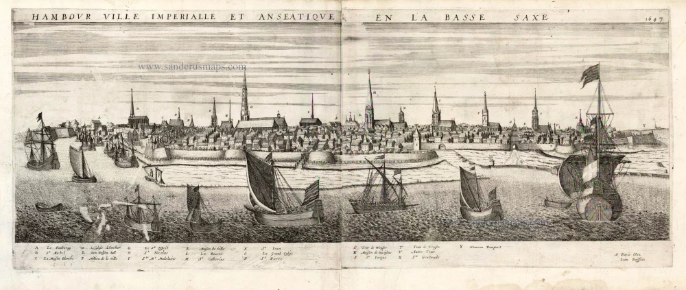
Hamburg by J. Boisseau. 1648
Jean Boisseau (flourished 1637-1658)
Jean Boisseau, a prolific map editor, remains somewhat mysterious. He was mentioned for the first time in the Parisian archives in 1631: he was then described as a "master illuminator," a title from which he would never give up. A little later, in 1635, he became a "nautical chart illuminator." Finally, in 1636, he published several heraldry works, genealogy, and chronology.
At the same time, he had a few maps engraved. In 1641 he reissued Jean Leclerc's Theatre and published the Topographie françoise de Châtillon. The following year, he improved Leclerc's atlas, which became his own Théatre des Gaules. In 1643, he copied Mercator-Hondius' Atlas Minor for his small Trésor des cartes géographiques. Very active until 1648, the date of the publication of the Théatre des Citéz and the second edition of the Topographie.
Boisseau then disappeared without leaving any heirs. Jean Boissevin recovered part of his collection and reissued the Trésor in 1653 and the Topographie in 1655.
Hambour Ville Imperiale et Anseatique en la Bassa Saxe. 1477
Item Number: 25580 Authenticity Guarantee
Category: Antique maps > Europe > Germany - Cities
Old antique map - panoramic view of Hamburg by Jean Boisseau.
Alte antike Karte - Ansicht der Stadt Hamburg durch Jean Boisseau.
With key to locations.
Date of the first edition: 1648
Date of this map: 1648 (= Rare first edition, with the address of Boisseau)
Date on map: 1647
Copper engraving, on two sheets, joined.
Engraver: H. Picart
Size (not including margins): 28 x 71.5cm (10.9 x 27.9 inches)
Verso: Blank
Condition: Excellent.
Condition Rating: A+
References: Pastoureau, Boisseau 1, 51.
From: Theatre des Citez, ou Recueil de plusieurs villes, dont les noms suivent par ordre alphabetique; Selon qu'ils sont contenues en ce present volume. Paris, Jean Boisseau, 1648.
Jean Boisseau (flourished 1637-1658)
Jean Boisseau, a prolific map editor, remains somewhat mysterious. He was mentioned for the first time in the Parisian archives in 1631: he was then described as a "master illuminator," a title from which he would never give up. A little later, in 1635, he became a "nautical chart illuminator." Finally, in 1636, he published several heraldry works, genealogy, and chronology.
At the same time, he had a few maps engraved. In 1641 he reissued Jean Leclerc's Theatre and published the Topographie françoise de Châtillon. The following year, he improved Leclerc's atlas, which became his own Théatre des Gaules. In 1643, he copied Mercator-Hondius' Atlas Minor for his small Trésor des cartes géographiques. Very active until 1648, the date of the publication of the Théatre des Citéz and the second edition of the Topographie.
Boisseau then disappeared without leaving any heirs. Jean Boissevin recovered part of his collection and reissued the Trésor in 1653 and the Topographie in 1655.
Related items

Celeberrimi Fluvii Albis nova delineatio 1642-43
Elbe River - Hamburg by Blaeu W.
[Item number: 18728]
new

Profil de la Ville de Hafnie vulgairement Copenhagen Cappitalle du Royaume de Danemarck. 1648
Copenhagen, by J. Boisseau.
[Item number: 25597]

Lubeca Urbs Imperialis Libera, Civitatum Wandalicarum, et Inclytae Hanseaticae Societatis Caput [on sheet with] Hamburga, Florentissimum Inferioris Saxoniae Emporium, Anglorum frequetatione hoc tepore celeberrimum A° Dñi: M.D.LXXII. 1574
Lubeck - Hamburg, by Georg Braun & Frans Hogenberg.
[Item number: 28037]

Lubeca Urbs Imperialis ... Inclytae Hanseaticae Societatis Caput. [on sheet with] Hamburga, Florentissimum Inferioris Saxoniae Emporium, Anglorum frequetatione hoc tepore celeberrimum A° Dni: M.D.LXXII. 1572
Lubeck and Hamburg, by Georg Braun and Frans Hogenberg.
[Item number: 29419]