
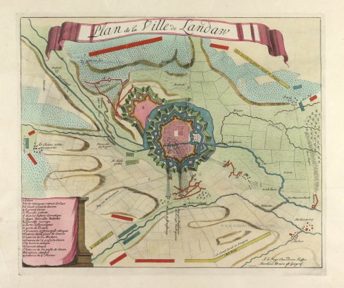
Siege of Landau in der Pfalz, by Pierre Husson. c. 1709

Pierre Husson (1678-1733)
Pierre (Pieter), a publisher in Den Haag, was a neighbour of Mrs Anna Beek, with whom he shared his interest in publishing plans of battlefields and fortifications during the War of Succession (1702-1713).
A collection of maps and plans by various authors was brought together in an atlas, to which was added the title page of Nicolas Visscher's Variae tabulae geographicae in quibus loca in orbe bello, now with the address of Pierre Husson.
Plan de la ville de Landaw.
Item Number: 29656 Authenticity Guarantee
Category: Antique maps > Europe > Germany - Cities
Old, antique plan of the Siege of Landau in der Pfalz, by Pierre Husson.
Title: Plan de la ville de Landaw.
A la Haije chez Pierre Husson Marchand libraire est Geograf.
Date: c. 1709.
Copper engraving, printed on paper.
Map size: 330 x 395mm (12.99 x 15.55 inches).
Sheet size: 425 x 520mm (16.73 x 20.47 inches).
Verso: Blank.
Condition: Original coloured, left bootom corner replaced (not affecting the image).
Condition Rating: A+.
From: Variae tabulae geographicae un quibus loca in orbe bello flagrantia conspiciuntur ut in Flandria, Brabantia, Leodiensi Tractu, Germania, Hungaria, . . . Diverses cartes de geographie, où l'on peut voir le theatre de la guerre dans tout le monde. Comme dans les pais de Flandres, de Brabant, de Liège, d'Allemagne, de Hongrie, . . . Den Haag, P. Husson, s.d. (c. 1709). (Koeman II, p. 155, Hus1)
Pierre Husson (1678-1733)
Pierre (Pieter), a publisher in Den Haag, was a neighbour of Mrs Anna Beek, with whom he shared his interest in publishing plans of battlefields and fortifications during the War of Succession (1702-1713).
A collection of maps and plans by various authors was brought together in an atlas, to which was added the title page of Nicolas Visscher's Variae tabulae geographicae in quibus loca in orbe bello, now with the address of Pierre Husson.
Related items

Schletzstat. - Selestad, ou Schletstad, cité impériale, située au milieu du pays d'Alsace. - La cité de Selestad, figurée au vif: et est située en une ferme place, et en terroir tres fécond. 1575
Landau in der Pfalz, by François de Belleforest.
[Item number: 27296]
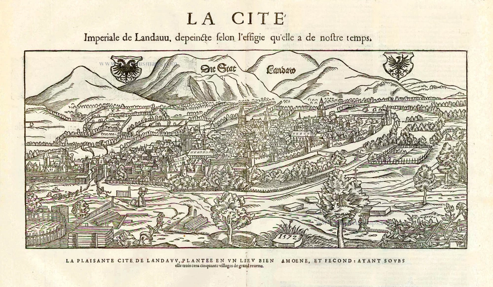
Die Stat Landaw. - La cité impériale de Landauu, depeincte selon l'effigie qu'elle a de nostre temps. - La plaisante cité de Landavv, plantée a un lieu bien amoene, et fecond: ayant soubs elle trois cens cinquante villages de grand revenue. 1572. 1575
Landau in der Pfalz by François de Belleforest
[Item number: 27297]