
Soest - Warburg by Georg Braun & Frans Hogenberg 1581-88

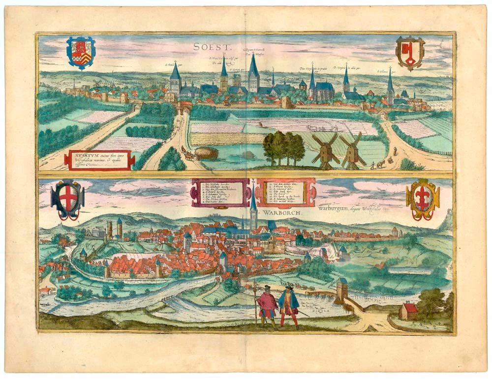


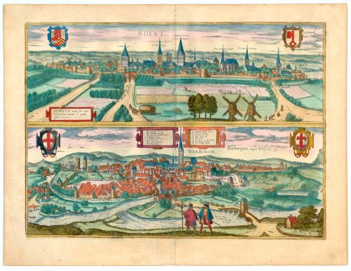
SOEST:
CARTOUCHE: Soest, among Westphalia's cities, almost the largest and most prosperous.
COMMENTARY BY BRAUN: "Although the farmland in Westphalia is generally better for woods and cattle pastures, the area around Soest and Hamm is still suitable for cultivating grain. Soest is also well known for its many salt mines. The town of Pfaffendorf, where the salt mines lie, supplies Soest with daily deliveries of such a quantity of precious salt sufficient to cover the city's needs and all its neighbouring towns far around. The owners of the salt mines, mostly nobles, are inhabitants of the city. The city itself maintains six mills for the general use."
This view shows the city from the southeast, which is dominated by numerous church spires.
WARBURG:
CAPTION: Warburg, a fine town in Westphalia.
COMMENTARY BY BRAUN: "Warburg, an attractive town in Westphalia, lies on hilly ground with the River Diemel flowing by. It formerly had the title of county, as Hermann Hamelmann records in his Westfälische Geschichte, where he also praises the town for its delicious beer, which is happily imbibed, in particular by those who seek humour for little expense."
This view from the south shows the town of Warburg, which is spread across several hills, the early Gothic church of St John the Baptist soars above the New Town in the central background. The Old Town in the foreground, which sprang up on an advantageous site on the Diemelfurt, is first mentioned in records of 1036. Following the foundation of the New Town in 1228 by the bishop of Paderborn, the two merged to form a single town in 1436. The town hall "between the town" was erected in 1568. On the far right is a glimpse of Desenberg castle, perched at a striking 340-m-high basalt bluff as if on an inselberg.
Braun G. & Hogenberg F. and the Civitates Orbis Terrarum.
The Civitates Orbis Terrarum, also known as the 'Braun & Hogenberg', is a six-volume town atlas and the most excellent book of town views and plans ever published: 363 engravings, sometimes beautifully coloured. It was one of the best-selling works in the last quarter of the 16th century. Georg Braun, a skilled writer, wrote the text accompanying the plans and views on the verso. Many plates were engraved after the original drawings of a professional artist, Joris Hoefnagel (1542-1600). The first volume was published in Latin in 1572 and the sixth in 1617. Frans Hogenberg, a talented engraver, created the tables for volumes I through IV, and Simon van den Neuwel made those for volumes V and VI. Other contributors were cartographers Daniel Freese and Heinrich Rantzau, who provided valuable geographical information. Works by Jacob van Deventer, Sebastian Münster, and Johannes Stumpf were also used as references. Translations appeared in German and French, making the atlas accessible to a broader audience.
Since its original publication of volume 1 in 1572, the Civitates Orbis Terrarum has left an indelible mark on the history of cartography. Seven more editions followed the first volume in 1575, 1577, 1582, 1588, 1593, 1599, and 1612. Vol.2, initially released in 1575, saw subsequent editions in 1597 and 1612. The subsequent volumes, each a treasure trove of historical insights, graced the world in 1581, 1588, 1593, 1599, and 1606. The German translation of the first volume, a testament to its widespread appeal, debuted in 1574, followed by the French edition in 1575.
Several printers were involved: Theodor Graminaeus, Heinrich von Aich, Gottfried von Kempen, Johannis Sinniger, Bertram Buchholtz, and Peter von Brachel, all of whom worked in Cologne.
Georg Braun (1541-1622)
Georg Braun, the author of the text accompanying the plans and views in the Civitates Orbis Terrarum, was born in Cologne in 1541. After his studies in Cologne, he entered the Jesuit Order as a novice, indicating his commitment to learning and intellectual pursuits. In 1561, he obtained his bachelor's degree; in 1562, he received his Magister Artium, further demonstrating his academic achievements. Although he left the Jesuit Order, he continued his studies in theology, gaining a licentiate in theology. His theological background likely influenced the content and tone of the text in the Civitates Orbis Terrarum, adding a unique perspective to the work.
Frans Hogenberg (1535-1590)
Frans Hogenberg was a Flemish and German painter, engraver, and mapmaker. He was born in Mechelen as the son of Nicolaas Hogenberg.
By the end of the 1560s, Frans Hogenberg was employed upon Abraham Ortelius's Theatrum Orbis Terrarum, published in 1570; he is named an engraver of numerous maps. In 1568, he was banned from Antwerp by the Duke of Alva and travelled to London, where he stayed a few years before emigrating to Cologne. He immediately embarked on his two most important works, the Civitates, published in 1572 and the Geschichtsblätter, which appeared in several series from 1569 until about 1587.
Thanks to large-scale projects like the Geschichtsblätter and the Civitates, Hogenberg's social circumstances improved with each passing year. He died as a wealthy man in Cologne in 1590.
Soest [on sheet with] Warborch - Warburgum, elegans Westphaliae Opp.
Item Number: 23207 Authenticity Guarantee
Category: Antique maps > Europe > Germany - Cities
Two views: Soest & Warburg by Georg Braun & Frans Hogenberg.
Title: Soest [on sheet with] Warborch - Warburgum, elegans Westphaliae Opp.
Date: 1581-88.
Copper engraving, printed on paper.
Size (not including margins): 345 x 475mm (13.58 x 18.7 inches).
Verso: Latin text.
Condition: Old coloured.
Condition Rating: A+.
From: Civitates Orbis Terrarum. . Liber Tertius. Köln, G. Kempen, 1581-88. (Koeman, B&H3)
SOEST:
CARTOUCHE: Soest, among Westphalia's cities, almost the largest and most prosperous.
COMMENTARY BY BRAUN: "Although the farmland in Westphalia is generally better for woods and cattle pastures, the area around Soest and Hamm is still suitable for cultivating grain. Soest is also well known for its many salt mines. The town of Pfaffendorf, where the salt mines lie, supplies Soest with daily deliveries of such a quantity of precious salt sufficient to cover the city's needs and all its neighbouring towns far around. The owners of the salt mines, mostly nobles, are inhabitants of the city. The city itself maintains six mills for the general use."
This view shows the city from the southeast, which is dominated by numerous church spires.
WARBURG:
CAPTION: Warburg, a fine town in Westphalia.
COMMENTARY BY BRAUN: "Warburg, an attractive town in Westphalia, lies on hilly ground with the River Diemel flowing by. It formerly had the title of county, as Hermann Hamelmann records in his Westfälische Geschichte, where he also praises the town for its delicious beer, which is happily imbibed, in particular by those who seek humour for little expense."
This view from the south shows the town of Warburg, which is spread across several hills, the early Gothic church of St John the Baptist soars above the New Town in the central background. The Old Town in the foreground, which sprang up on an advantageous site on the Diemelfurt, is first mentioned in records of 1036. Following the foundation of the New Town in 1228 by the bishop of Paderborn, the two merged to form a single town in 1436. The town hall "between the town" was erected in 1568. On the far right is a glimpse of Desenberg castle, perched at a striking 340-m-high basalt bluff as if on an inselberg.
Braun G. & Hogenberg F. and the Civitates Orbis Terrarum.
The Civitates Orbis Terrarum, also known as the 'Braun & Hogenberg', is a six-volume town atlas and the most excellent book of town views and plans ever published: 363 engravings, sometimes beautifully coloured. It was one of the best-selling works in the last quarter of the 16th century. Georg Braun, a skilled writer, wrote the text accompanying the plans and views on the verso. Many plates were engraved after the original drawings of a professional artist, Joris Hoefnagel (1542-1600). The first volume was published in Latin in 1572 and the sixth in 1617. Frans Hogenberg, a talented engraver, created the tables for volumes I through IV, and Simon van den Neuwel made those for volumes V and VI. Other contributors were cartographers Daniel Freese and Heinrich Rantzau, who provided valuable geographical information. Works by Jacob van Deventer, Sebastian Münster, and Johannes Stumpf were also used as references. Translations appeared in German and French, making the atlas accessible to a broader audience.
Since its original publication of volume 1 in 1572, the Civitates Orbis Terrarum has left an indelible mark on the history of cartography. Seven more editions followed the first volume in 1575, 1577, 1582, 1588, 1593, 1599, and 1612. Vol.2, initially released in 1575, saw subsequent editions in 1597 and 1612. The subsequent volumes, each a treasure trove of historical insights, graced the world in 1581, 1588, 1593, 1599, and 1606. The German translation of the first volume, a testament to its widespread appeal, debuted in 1574, followed by the French edition in 1575.
Several printers were involved: Theodor Graminaeus, Heinrich von Aich, Gottfried von Kempen, Johannis Sinniger, Bertram Buchholtz, and Peter von Brachel, all of whom worked in Cologne.
Georg Braun (1541-1622)
Georg Braun, the author of the text accompanying the plans and views in the Civitates Orbis Terrarum, was born in Cologne in 1541. After his studies in Cologne, he entered the Jesuit Order as a novice, indicating his commitment to learning and intellectual pursuits. In 1561, he obtained his bachelor's degree; in 1562, he received his Magister Artium, further demonstrating his academic achievements. Although he left the Jesuit Order, he continued his studies in theology, gaining a licentiate in theology. His theological background likely influenced the content and tone of the text in the Civitates Orbis Terrarum, adding a unique perspective to the work.
Frans Hogenberg (1535-1590)
Frans Hogenberg was a Flemish and German painter, engraver, and mapmaker. He was born in Mechelen as the son of Nicolaas Hogenberg.
By the end of the 1560s, Frans Hogenberg was employed upon Abraham Ortelius's Theatrum Orbis Terrarum, published in 1570; he is named an engraver of numerous maps. In 1568, he was banned from Antwerp by the Duke of Alva and travelled to London, where he stayed a few years before emigrating to Cologne. He immediately embarked on his two most important works, the Civitates, published in 1572 and the Geschichtsblätter, which appeared in several series from 1569 until about 1587.
Thanks to large-scale projects like the Geschichtsblätter and the Civitates, Hogenberg's social circumstances improved with each passing year. He died as a wealthy man in Cologne in 1590.
