Eisleben - Tübingen by Georg Braun & Frans Hogenberg 1612

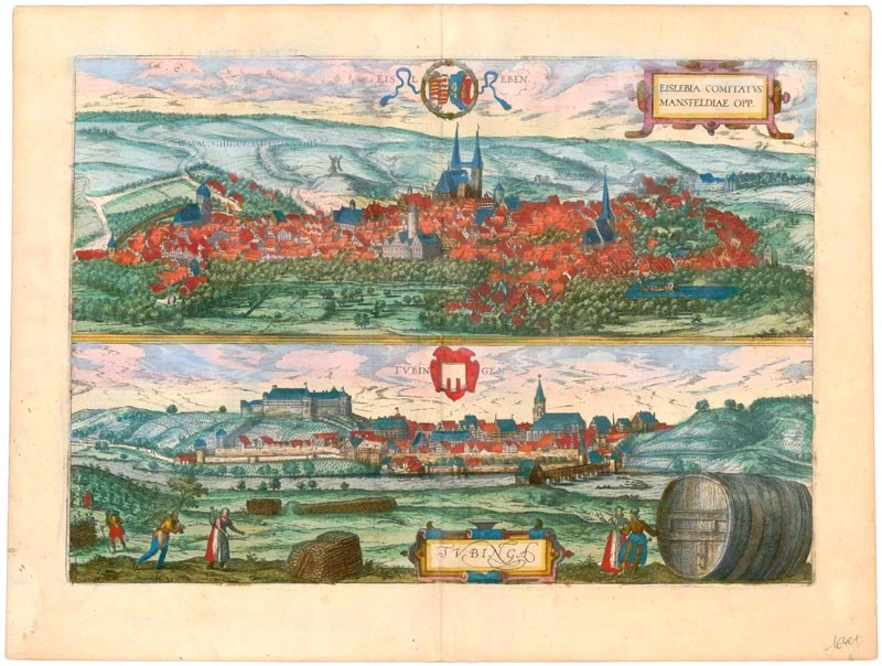

EISLEBEN
CARTOUCHE: Eisleben, a city in the County of Mansfeld.
COMMENTARY BY BRAUN (on verso): "In the vicinity of Eisleben, Manstein and Hettstedt are found, black stone that is easy to split. [...] Nor should what appears to be a marvel of cunning Nature be passed over in silence that the images and imprints of all kinds of beasts can be seen on said stone with its golden-hued petrifactions, and each figure can be readily recognized. Many think that it merely shows the creatures from the lake at Eisleben, such as fishes, eels, carp and frogs; others, however, say that figures of other animals can be seen on them, such as chickens, cockerels or salamanders. Indeed they say that the image of the Pope with his beard and tiara was found on one of these stones."
The cavalier perspective shows Eisleben in the Mansfelder Mulde from the northeast. At the centre is the seat of the Counts of Mansfeld, originally a moated castle with a high keep, and behind it the market church of St Andrew with its twin towers and in front of it the town hall (left). Copper mining attracted so many immigrants that the city had to be enlarged several times. New churches were built: SS Peter and Paul (left) to the south, the church in which Martin Luther was baptized, and St Nicholas (right) to the north. St Catherine's hospice for elderly miners is visible in the right background. The city owes to its native son Martin Luther (whom the theologist Georg Braun ignores along with the problem arising for an explanation of the biblical Creation by the discovery he mentions of fossils in cupriferous shale) the honour of being designated a Unesco World Heritage Site.
TÜBINGEN
COMMENTARY BY BRAUN (on verso): "Eberhard, Duke of Württemberg, had learnt no Latin (this omission was due to the neglect of the guardians who brought him up) yet he sought the company of learned men. He read many German books, from which he drew much knowledge and insight. He also had many writings translated from Latin into German, his mother tongue. Since he saw what esteem scholarly and pious men enjoyed and what good treatment they were accustomed to receiving, but had no institution of higher learning in his duchy at which the scions of his subjects might be introduced to, and instructed in, the liberal arts, he had a university and an institute invested with papal and imperial privileges built in his city of Tübingen, in 1477."
This view from the south shows the university town of Tübingen on the Neckar, framed in vineyards. The foreground staffage is another allusion to wine-growing in Tübingen. Converted into a ducal residence in the 16th/17th centuries, Hohentübingen castle overshadows the town. It was one of the seats of the Dukes of Württemberg, and the city grew up around it in the late 12th century. At the foot of the castle hill, to the right, are the Lutheran chapter house, endowed in 1536 by Duke Ulrich, and the town hall.
The view is made after a woodcut by Jonathan Sauter. (Taschen)
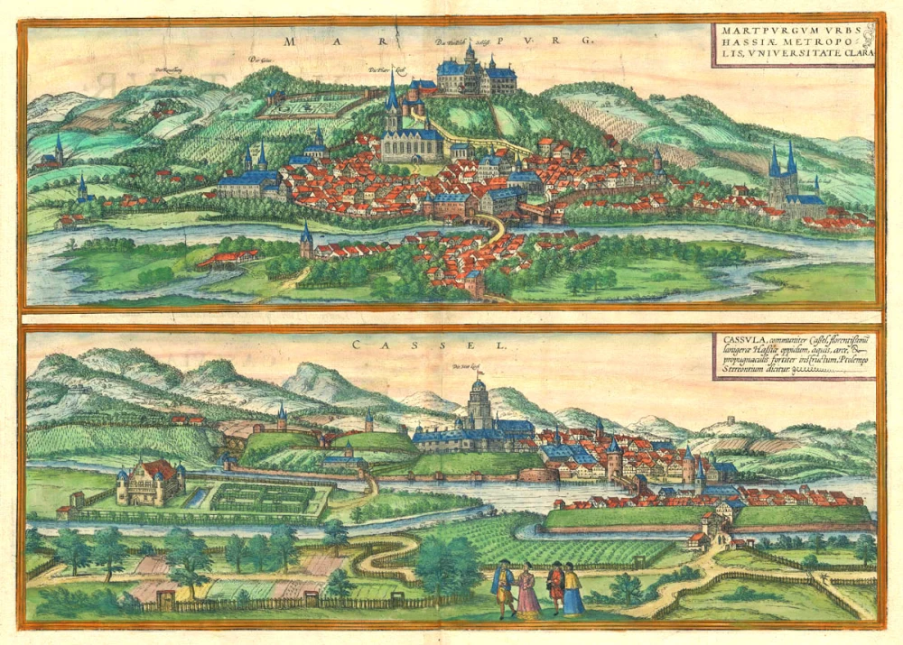
Braun G. & Hogenberg F. and the Civitates Orbis Terrarum.
The Civitates Orbis Terrarum, also known as the 'Braun & Hogenberg', is a six-volume town atlas and the most excellent book of town views and plans ever published: 363 engravings, sometimes beautifully coloured. It was one of the best-selling works in the last quarter of the 16th century. Georg Braun, a skilled writer, wrote the text accompanying the plans and views on the verso. Many plates were engraved after the original drawings of a professional artist, Joris Hoefnagel (1542-1600). The first volume was published in Latin in 1572 and the sixth in 1617. Frans Hogenberg, a talented engraver, created the tables for volumes I through IV, and Simon van den Neuwel made those for volumes V and VI. Other contributors were cartographers Daniel Freese and Heinrich Rantzau, who provided valuable geographical information. Works by Jacob van Deventer, Sebastian Münster, and Johannes Stumpf were also used as references. Translations appeared in German and French, making the atlas accessible to a broader audience.
Since its original publication of volume 1 in 1572, the Civitates Orbis Terrarum has left an indelible mark on the history of cartography. Seven more editions followed the first volume in 1575, 1577, 1582, 1588, 1593, 1599, and 1612. Vol.2, initially released in 1575, saw subsequent editions in 1597 and 1612. The subsequent volumes, each a treasure trove of historical insights, graced the world in 1581, 1588, 1593, 1599, and 1606. The German translation of the first volume, a testament to its widespread appeal, debuted in 1574, followed by the French edition in 1575.
Several printers were involved: Theodor Graminaeus, Heinrich von Aich, Gottfried von Kempen, Johannis Sinniger, Bertram Buchholtz, and Peter von Brachel, all of whom worked in Cologne.
Georg Braun (1541-1622)
Georg Braun, the author of the text accompanying the plans and views in the Civitates Orbis Terrarum, was born in Cologne in 1541. After his studies in Cologne, he entered the Jesuit Order as a novice, indicating his commitment to learning and intellectual pursuits. In 1561, he obtained his bachelor's degree; in 1562, he received his Magister Artium, further demonstrating his academic achievements. Although he left the Jesuit Order, he continued his studies in theology, gaining a licentiate in theology. His theological background likely influenced the content and tone of the text in the Civitates Orbis Terrarum, adding a unique perspective to the work.
Frans Hogenberg (1535-1590)
Frans Hogenberg was a Flemish and German painter, engraver, and mapmaker. He was born in Mechelen as the son of Nicolaas Hogenberg.
By the end of the 1560s, Frans Hogenberg was employed upon Abraham Ortelius's Theatrum Orbis Terrarum, published in 1570; he is named an engraver of numerous maps. In 1568, he was banned from Antwerp by the Duke of Alva and travelled to London, where he stayed a few years before emigrating to Cologne. He immediately embarked on his two most important works, the Civitates, published in 1572 and the Geschichtsblätter, which appeared in several series from 1569 until about 1587.
Thanks to large-scale projects like the Geschichtsblätter and the Civitates, Hogenberg's social circumstances improved with each passing year. He died as a wealthy man in Cologne in 1590.
Eisleben - Eislebia Comitatus Mansfeldiae Opp. [on sheet with] Tubingen - Tubinga
Item Number: 16401 Authenticity Guarantee
Category: Antique maps > Europe > Germany - Cities
Two bird's-eye views by Georg Braun and Frans Hogenberg on one sheet: Eisleben and Tübingen.
Title: Eisleben - Eislebia Comitatus Mansfeldiae Opp. [on sheet with] Tubingen - Tubinga
Date of the first edition: 1588.
Date of this map: 1612.
Copper engraving, printed on paper.
Size (not including margins): 332 x 470mm (13.07 x 18.5 inches).
Verso: Latin text.
Condition: Excellent, superb old colour.
Condition Rating: A+
References: Van der Krogt 4, #1210; Taschen, Br. Hog., p. 316; Fauser, #3539, #14310
From: Liber Quartus Urbium Praecipuarum Totius Mundi. Cologne,Petrus von Brachel, 1612. (Van der Krogt 4, 41:1.4(1612))
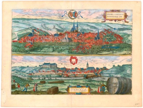
EISLEBEN
CARTOUCHE: Eisleben, a city in the County of Mansfeld.
COMMENTARY BY BRAUN (on verso): "In the vicinity of Eisleben, Manstein and Hettstedt are found, black stone that is easy to split. [...] Nor should what appears to be a marvel of cunning Nature be passed over in silence that the images and imprints of all kinds of beasts can be seen on said stone with its golden-hued petrifactions, and each figure can be readily recognized. Many think that it merely shows the creatures from the lake at Eisleben, such as fishes, eels, carp and frogs; others, however, say that figures of other animals can be seen on them, such as chickens, cockerels or salamanders. Indeed they say that the image of the Pope with his beard and tiara was found on one of these stones."
The cavalier perspective shows Eisleben in the Mansfelder Mulde from the northeast. At the centre is the seat of the Counts of Mansfeld, originally a moated castle with a high keep, and behind it the market church of St Andrew with its twin towers and in front of it the town hall (left). Copper mining attracted so many immigrants that the city had to be enlarged several times. New churches were built: SS Peter and Paul (left) to the south, the church in which Martin Luther was baptized, and St Nicholas (right) to the north. St Catherine's hospice for elderly miners is visible in the right background. The city owes to its native son Martin Luther (whom the theologist Georg Braun ignores along with the problem arising for an explanation of the biblical Creation by the discovery he mentions of fossils in cupriferous shale) the honour of being designated a Unesco World Heritage Site.
TÜBINGEN
COMMENTARY BY BRAUN (on verso): "Eberhard, Duke of Württemberg, had learnt no Latin (this omission was due to the neglect of the guardians who brought him up) yet he sought the company of learned men. He read many German books, from which he drew much knowledge and insight. He also had many writings translated from Latin into German, his mother tongue. Since he saw what esteem scholarly and pious men enjoyed and what good treatment they were accustomed to receiving, but had no institution of higher learning in his duchy at which the scions of his subjects might be introduced to, and instructed in, the liberal arts, he had a university and an institute invested with papal and imperial privileges built in his city of Tübingen, in 1477."
This view from the south shows the university town of Tübingen on the Neckar, framed in vineyards. The foreground staffage is another allusion to wine-growing in Tübingen. Converted into a ducal residence in the 16th/17th centuries, Hohentübingen castle overshadows the town. It was one of the seats of the Dukes of Württemberg, and the city grew up around it in the late 12th century. At the foot of the castle hill, to the right, are the Lutheran chapter house, endowed in 1536 by Duke Ulrich, and the town hall.
The view is made after a woodcut by Jonathan Sauter. (Taschen)
Braun G. & Hogenberg F. and the Civitates Orbis Terrarum.
The Civitates Orbis Terrarum, also known as the 'Braun & Hogenberg', is a six-volume town atlas and the most excellent book of town views and plans ever published: 363 engravings, sometimes beautifully coloured. It was one of the best-selling works in the last quarter of the 16th century. Georg Braun, a skilled writer, wrote the text accompanying the plans and views on the verso. Many plates were engraved after the original drawings of a professional artist, Joris Hoefnagel (1542-1600). The first volume was published in Latin in 1572 and the sixth in 1617. Frans Hogenberg, a talented engraver, created the tables for volumes I through IV, and Simon van den Neuwel made those for volumes V and VI. Other contributors were cartographers Daniel Freese and Heinrich Rantzau, who provided valuable geographical information. Works by Jacob van Deventer, Sebastian Münster, and Johannes Stumpf were also used as references. Translations appeared in German and French, making the atlas accessible to a broader audience.
Since its original publication of volume 1 in 1572, the Civitates Orbis Terrarum has left an indelible mark on the history of cartography. Seven more editions followed the first volume in 1575, 1577, 1582, 1588, 1593, 1599, and 1612. Vol.2, initially released in 1575, saw subsequent editions in 1597 and 1612. The subsequent volumes, each a treasure trove of historical insights, graced the world in 1581, 1588, 1593, 1599, and 1606. The German translation of the first volume, a testament to its widespread appeal, debuted in 1574, followed by the French edition in 1575.
Several printers were involved: Theodor Graminaeus, Heinrich von Aich, Gottfried von Kempen, Johannis Sinniger, Bertram Buchholtz, and Peter von Brachel, all of whom worked in Cologne.
Georg Braun (1541-1622)
Georg Braun, the author of the text accompanying the plans and views in the Civitates Orbis Terrarum, was born in Cologne in 1541. After his studies in Cologne, he entered the Jesuit Order as a novice, indicating his commitment to learning and intellectual pursuits. In 1561, he obtained his bachelor's degree; in 1562, he received his Magister Artium, further demonstrating his academic achievements. Although he left the Jesuit Order, he continued his studies in theology, gaining a licentiate in theology. His theological background likely influenced the content and tone of the text in the Civitates Orbis Terrarum, adding a unique perspective to the work.
Frans Hogenberg (1535-1590)
Frans Hogenberg was a Flemish and German painter, engraver, and mapmaker. He was born in Mechelen as the son of Nicolaas Hogenberg.
By the end of the 1560s, Frans Hogenberg was employed upon Abraham Ortelius's Theatrum Orbis Terrarum, published in 1570; he is named an engraver of numerous maps. In 1568, he was banned from Antwerp by the Duke of Alva and travelled to London, where he stayed a few years before emigrating to Cologne. He immediately embarked on his two most important works, the Civitates, published in 1572 and the Geschichtsblätter, which appeared in several series from 1569 until about 1587.
Thanks to large-scale projects like the Geschichtsblätter and the Civitates, Hogenberg's social circumstances improved with each passing year. He died as a wealthy man in Cologne in 1590.