
Franken - Munster, by Abraham Ortelius. 1571

Abraham Ortelius (1527-1598)
The maker of the 'first atlas', the Theatrum Orbis Terrarum (1570), was born on 4 April 1527 into an old Antwerp family. He learned Latin and studied Greek and mathematics.
Abraham and his sisters, Anne and Elizabeth, took up map colouring. Ortelius was admitted to the Guild of St. Luke as an "illuminator of maps." In addition to colouring maps, Ortelius was a dealer in antiques, coins, maps, and books, and the book and map trade gradually became his primary occupation.
Business went well because his means allowed him to amass an extensive collection of medals, coins, and antiques, as well as a library of many volumes. In addition, he travelled extensively, visited Italy and France, made contacts with scholars and editors everywhere, and maintained extensive correspondence with them.
In 1564, he published his first map, a large and ambitious world wall map. The inspiration for this map may well have been Gastaldi's large world map. In 1565, he published a map of Egypt and a map of the Holy Land; a large map of Asia followed.
In 1568, the production of individual maps for his atlas Theatrum Orbis Terrarum was already in full swing. He completed the atlas in 1569, and in May 1570, it was available for sale. It was one of the most expensive books ever published.
This first edition contained seventy maps on fifty-three sheets. Franciscus Hogenberg engraved the maps.
Later editions included Additamenta (additions), resulting in Ortelius' historical atlas, the Parergon, which is mainly bound together with the atlas. The Parergon can be considered a truly original work by Ortelius, who drew the maps based on his research.
The importance of the Theatrum Orbis Terrarum for geographical knowledge in the last quarter of the sixteenth century is difficult to overemphasise. Nothing was like it until Mercator's atlas appeared twenty-five years later. Demand for the Theatrum was remarkable. Some 24 editions appeared during Ortelius's lifetime, and another 10 after he died in 1598. Editions were published in Dutch, German, French, Spanish, English, and Italian. The number of map sheets grew from 53 in 1570 to 167 in the last edition in 1612.
In 1577, engraver Philip Galle and poet-translator Pieter Heyns published the first pocket-sized edition of the Theatrum, the Epitome. The work was trendy. Over thirty editions of this Epitome were published in different languages.
Ortelius is also remembered for an early idea resembling continental drift: he suggested that the Americas, Europe, and Africa may once have been joined together before separating over time. His work helped shape the development of modern geography and mapmaking.
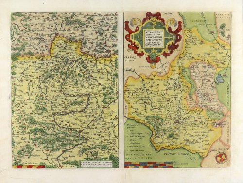
Franciae Orientalis (vulgo Franckenlant) Descriptio, Auctore, Sebast. A Rotenhan. [on sheet with:] Monasteriensis et Osnaburgensis Episcopatus Descriptio.
Item Number: 6893 Authenticity Guarantee
Category: Antique maps > Europe > Germany
Franken - Munster, by Abraham Ortelius.
Title: Franciae Orientalis (vulgo Franckenlant) Descriptio, Auctore, Sebast. A Rotenhan. [on sheet with:] Monasteriensis et Osnaburgensis Episcopatus Descriptio.
Auctore Godefrido Mascop Embricense.
Cum privilegio.
Cartographer: Sebastian Rotenhan (Franken) & Godfried Mascop (Munster).
Date of the first edition: 1570.
Date of this map: 1571.
Copper engraving, printed on paper.
Image size: 367 x 512mm (14.45 x 20.16 inches).
Sheet size: 445 x 590mm (17.52 x 23.23 inches).
Verso: Latin text.
Condition: Excellent.
Condition Rating: A+.
From: Theatrum Orbis Terrarum Antwerpen, Anthonis Coppens van Diest, 1571. (Van der Krogt 3, 31:002)
Abraham Ortelius (1527-1598)
The maker of the 'first atlas', the Theatrum Orbis Terrarum (1570), was born on 4 April 1527 into an old Antwerp family. He learned Latin and studied Greek and mathematics.
Abraham and his sisters, Anne and Elizabeth, took up map colouring. Ortelius was admitted to the Guild of St. Luke as an "illuminator of maps." In addition to colouring maps, Ortelius was a dealer in antiques, coins, maps, and books, and the book and map trade gradually became his primary occupation.
Business went well because his means allowed him to amass an extensive collection of medals, coins, and antiques, as well as a library of many volumes. In addition, he travelled extensively, visited Italy and France, made contacts with scholars and editors everywhere, and maintained extensive correspondence with them.
In 1564, he published his first map, a large and ambitious world wall map. The inspiration for this map may well have been Gastaldi's large world map. In 1565, he published a map of Egypt and a map of the Holy Land; a large map of Asia followed.
In 1568, the production of individual maps for his atlas Theatrum Orbis Terrarum was already in full swing. He completed the atlas in 1569, and in May 1570, it was available for sale. It was one of the most expensive books ever published.
This first edition contained seventy maps on fifty-three sheets. Franciscus Hogenberg engraved the maps.
Later editions included Additamenta (additions), resulting in Ortelius' historical atlas, the Parergon, which is mainly bound together with the atlas. The Parergon can be considered a truly original work by Ortelius, who drew the maps based on his research.
The importance of the Theatrum Orbis Terrarum for geographical knowledge in the last quarter of the sixteenth century is difficult to overemphasise. Nothing was like it until Mercator's atlas appeared twenty-five years later. Demand for the Theatrum was remarkable. Some 24 editions appeared during Ortelius's lifetime, and another 10 after he died in 1598. Editions were published in Dutch, German, French, Spanish, English, and Italian. The number of map sheets grew from 53 in 1570 to 167 in the last edition in 1612.
In 1577, engraver Philip Galle and poet-translator Pieter Heyns published the first pocket-sized edition of the Theatrum, the Epitome. The work was trendy. Over thirty editions of this Epitome were published in different languages.
Ortelius is also remembered for an early idea resembling continental drift: he suggested that the Americas, Europe, and Africa may once have been joined together before separating over time. His work helped shape the development of modern geography and mapmaking.
Related items

Mansfeldiae Comitatus Descriptio. 1601
Mansfeld, by Ortelius A.
[Item number: 8023]

Saxoniae, Misniae, Thuringiae, Nova Exactissima que Descriptio. 1581
Old, antique map of Obersachsen, Meissen, Thüringen by Ortelius A.
[Item number: 17545]

Thietmarsiae, Holsaticae Regionis Partis Typus. - Oldenburg Comit. 1612
Dithmarschen - Oldenburg, by Abraham Ortelius.
[Item number: 18704]

Monasterium, Urbs in Media Westphalia Celeberrimi Nominis ... [on sheet with] Osnabrugum Elegans Saxoniae Opp. [and] Wesalia Inferior. 1582
Munster - Osnabruck - Wesel by Braun & Hogenberg
[Item number: 25492]

Franconiae Nova Descriptio. 1653
Franconia by Johannes Janssonius.
[Item number: 30371]