
GERMANY by Joannes Janssonius 1630

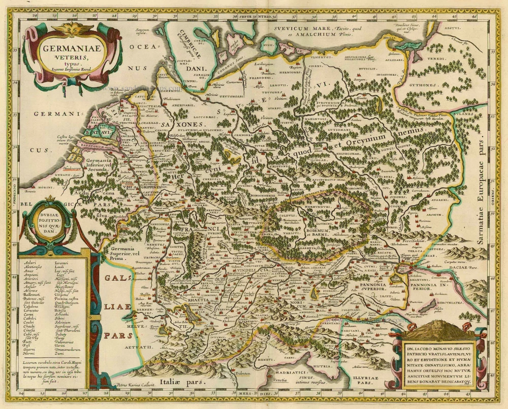
This map is framed on four sides by decorative borders. The top border contains portraits of Emperor Matthias with the seven Electors, all on horseback. Matthias is shown twice: as Emperor, and as King of Bohemia and Hungary.
The map image is framed by shields with coats of arms along both side borders and the bottom border showing the hierarchy of the Holy Roman empire in the form of Quarternions. Along the bottom border runs a strip with ten town views in oval frames. The depictions on Willem Jansz's 1609 map served as models for all these town views. The coats of arms along the side borders are flanked by costumed figures.
The Janssonius Family
Joannes Janssonius (Arnhem, 1588-1664), son of the Arnhem publisher Jan Janssen, married Elisabeth Hondius, daughter of Jodocus Hondius, in Amsterdam in 1612. After his marriage, he settled down in this town as a bookseller and publisher of cartographic material. In 1618, he established himself in Amsterdam next door to Blaeu’s bookshop. He entered into serious competition with Willem Jansz. Blaeu when copying Blaeu’s Licht der Zeevaert after the expiration of the privilege in 1620. His activities concerned the publication of atlases, books, single maps, and an extensive book trade with branches in Frankfurt, Danzig, Stockholm, Copenhagen, Berlin, Koningsbergen, Geneva, and Lyon. In 1631, he began publishing atlases together with Henricus Hondius.
In the early 1640s, Henricus Hondius left the atlas publishing business to Janssonius. Competition with Joan Blaeu, Willem’s son and successor, in atlas production, prompted Janssonius to enlarge his Atlas Novus finally into a work of six volumes, into which a sea atlas and an atlas of the Old World were inserted. Other atlases published by Janssonius are Mercator’s Atlas Minor, Hornius’s historical atlas (1652), the townbooks in eight volumes (1657), Cellarius’s Atlas Coelestis and several sea atlases and pilot guides.
After the death of Joannes Janssonius, the shop and publishing firm were continued by the heirs under the direction of Johannes van Waesbergen (c. 1616-1681), son-in-law of Joannes Janssonius. Van Waesbergen added Janssonius's name to his own.
In 1676, Joannes Janssonius’s heirs sold by auction “all the remaining Atlases in Latin, French, High and Low German, as well as the Stedeboecken in Latin, in 8 volumes, bound and unbound, maps, plates belonging to the Atlas and Stedeboecken.” The copperplates from Janssonius’s atlases were afterwards sold to Schenk and Valck.
Nova Germaniae Descriptio.
Item Number: 22490 Authenticity Guarantee
Category: Antique maps > Europe > Germany
Old, antique map of Germania, by Johannes Janssonius.
Alte antike Karte von Germania, von Johannes Janssonius.
Date of the first edition: 1615 = Petrus Kaerius (Van der Keere)
Date of this map: 1630
Copper engraving, printed on paper.
Size (not including margins): 46 x 56cm (17.9 x 21.8 inches)
Verso: Blank
Condition: Original coloured, narrow left and upper margins, a few small marginal tears repaired.
Condition Rating: B
References: Schilder 6, 33.2 (2nd state with 1626 date); Van der Krogt 1, 2000:1B.
From: Atlantis Maioris Appendix, sive Pars Altera, ... Amsterdam, J. Janssonius, 1630. (Van der Krogt 1, 1:202)
This map is framed on four sides by decorative borders. The top border contains portraits of Emperor Matthias with the seven Electors, all on horseback. Matthias is shown twice: as Emperor, and as King of Bohemia and Hungary.
The map image is framed by shields with coats of arms along both side borders and the bottom border showing the hierarchy of the Holy Roman empire in the form of Quarternions. Along the bottom border runs a strip with ten town views in oval frames. The depictions on Willem Jansz's 1609 map served as models for all these town views. The coats of arms along the side borders are flanked by costumed figures.
The Janssonius Family
Joannes Janssonius (Arnhem, 1588-1664), son of the Arnhem publisher Jan Janssen, married Elisabeth Hondius, daughter of Jodocus Hondius, in Amsterdam in 1612. After his marriage, he settled down in this town as a bookseller and publisher of cartographic material. In 1618, he established himself in Amsterdam next door to Blaeu’s bookshop. He entered into serious competition with Willem Jansz. Blaeu when copying Blaeu’s Licht der Zeevaert after the expiration of the privilege in 1620. His activities concerned the publication of atlases, books, single maps, and an extensive book trade with branches in Frankfurt, Danzig, Stockholm, Copenhagen, Berlin, Koningsbergen, Geneva, and Lyon. In 1631, he began publishing atlases together with Henricus Hondius.
In the early 1640s, Henricus Hondius left the atlas publishing business to Janssonius. Competition with Joan Blaeu, Willem’s son and successor, in atlas production, prompted Janssonius to enlarge his Atlas Novus finally into a work of six volumes, into which a sea atlas and an atlas of the Old World were inserted. Other atlases published by Janssonius are Mercator’s Atlas Minor, Hornius’s historical atlas (1652), the townbooks in eight volumes (1657), Cellarius’s Atlas Coelestis and several sea atlases and pilot guides.
After the death of Joannes Janssonius, the shop and publishing firm were continued by the heirs under the direction of Johannes van Waesbergen (c. 1616-1681), son-in-law of Joannes Janssonius. Van Waesbergen added Janssonius's name to his own.
In 1676, Joannes Janssonius’s heirs sold by auction “all the remaining Atlases in Latin, French, High and Low German, as well as the Stedeboecken in Latin, in 8 volumes, bound and unbound, maps, plates belonging to the Atlas and Stedeboecken.” The copperplates from Janssonius’s atlases were afterwards sold to Schenk and Valck.
Related items

S.R.I. in Germania ... c. 1715
Germania, by F. de Wit - Covens & Mortier.
[Item number: 1262]
Germaniae Veteris, typus. 1630
GERMANY by Joannes Janssonius
[Item number: 21525]

Germania 1598
Germania, by A. Ortelius.
[Item number: 22916]

Le Cercle de la Haute Saxe ou sont Compris le Duche et Electorat de Saxe Les Marquisats de Misnie et de Lusace Le Landgraviat de Thuringe ... 1710
Eastern Germany, by Jaillot - Covens & Mortier.
[Item number: 23853]

Alsatia superior cum Suntgoia & Brisgoia. 1623
Haute-Alsace, by G. Mercator.
[Item number: 24968]