
Antique map of Trier - Koblenz - Rothenburg by Braun & Hogenberg 1572-1624


Treveris - Typus ac Situs antiquissimae ... [on sheet with] Cobolentz - Situs civitatis confluentinae, ... [and] Rotenburgum ad Tubarum, ...
Item Number: 6108 Authenticity Guarantee
Category: Antique maps > Europe > Germany
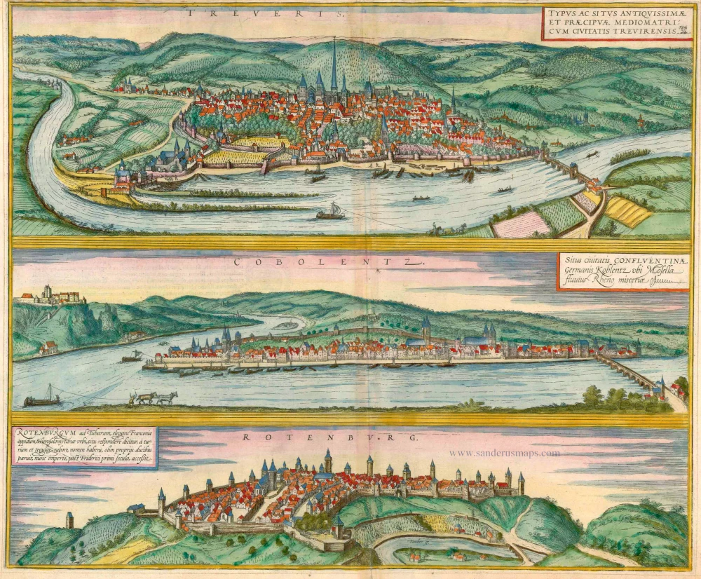
Three views on one sheet: Trier, Koblenz and Rothenburg.
TRIER
TRANSLATION OF CARTOUCHE TEXT: The picture shows the location of the ancient and outstanding city of Trier in the land of the Mediomatricians.
COMMENTARY BY BRAUN: "Trier is a special city on account of its famous deeds and also due to its great age. Ample evidence of how influential, wealthy and skilled the city was in earlier times is still provided by the magnificent ruins of old buildings. There is a wonderful palace here of fired bricks, like the walls of Babylon, built so solidly that it could not be destroyed by any means."
This illustration looks down upon the city from the left bank of the Moselle. Founded as Augusta Treverorum by Augustus in 16 BC, Trier is Germany's oldest city. Amongst its Roman remains, the massive basilica of Constantine from the start of the 4th century (right of the centre) is partucularly striking. Dominating the city centre is the architectural ensemble of three chruches: Trier cathedral, Germany's oldest sacred building, and beside it the early Gothic Liebfrauenkirche, with its distinctive tall crossing tower, followed by St Gangolf's.
KOBLENZ
CARTOUCHE: Site of the town of Confluentia, in German Koblenz, where the Moselle joins the Rhine.
COMMENTARY BY BRAUN: " Koblenz is a city in Gaul, between Mainz and Cologne, and subject to the bishop of Trier. The Moselle flows into the Rhine here, at such a speed that for a whole stretch you can recognize and distinguish between the two rivers from their different colours: the Moselle keeps to the left-hand side and the Rhine to the right."
The view shows Koblenz from the north. On the left, opposite the mouth of the Moselle, sits the 11th-century castle of Ehrenbreitstein, remodelled into a Trier electoral fortress at the start of the 16th century by Archbishop Richard von Greiffenklau zu Vollrads. On the far right the 325-m-long stone bridge over the Moselle was begun in 1342 by Elector Baldwin of Luxembourg and completed 85 years later. Near the spit of land (today called the Deutsches Eck) at the confluence of the two rivers stands the late Romanesque basilica of St Castor, and on the right the late Romanesque Liebfrauenkriche.
ROTHENBURG OB DER TAUBER
CARTOUCHE: Rothenburg ob der Tauber, a fine town in Franconia, is said to correspond to the city of Jerusalem in terms of location and takes its name from the redness of the towers and roof tiles. It was formerly ruled by its own Dukes, but joined the Empire after the time of Frederick I.
View of the small town from the opposite side of the Tauber Valley. Rothenburg "above the Tauber" is still known for its picturesque cityscape, and the numerous towers along the medieval ramparts in the engraving punctuate the skyline even today. Visible on the left with its two towers is the parish church of St James, which in 1544 became Protestant and which houses Tilman Riemenschneider's famous Altarpiece of the Holy Blood from the early 16th century. (Taschen)
Copper engraving
Size: 38.5 x 46.5cm (15 x 18.1 inches)
Verso text: Latin
Condition: Old coloured, upper margin partly trimmed to neatline.
Condition Rating: A
References: Taschen, Braun and Hogenberg, p.99.
From: Civitates Orbis Terrarum, ... Part 1. Köln, 1572-1624.