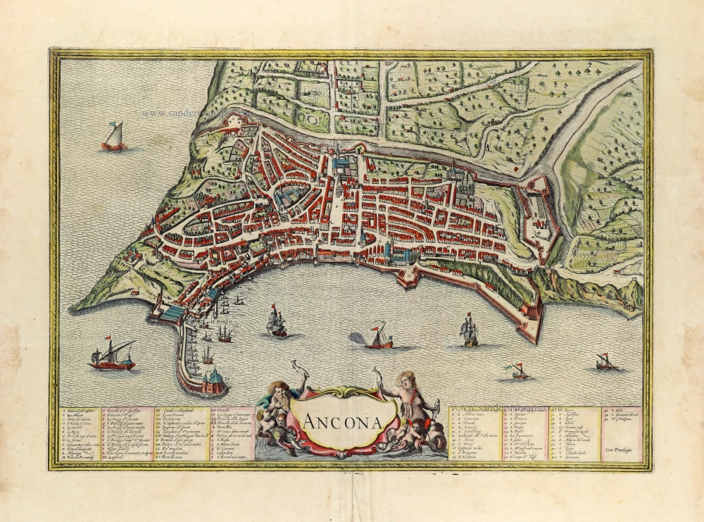
Ancona, by Georg Braun & Frans Hogenberg. 1582
TRANSLATION OF CARTOUCHE TEXT: Ancona, a famous city in Picenum on the Adriatic, is embellished by a most excellent harbour: there is namely none more commodious or spacious in all of Italy. It takes its name from its location, which resembles the crook of an elbow. It is famed for its trade and has an abundance of grain and wine and all other necessities of life: it is redolent everywhere of great age.
COMMENTARY BY BRAUN: "Ancona lies on a promontory that runs down to the Adriatic. And as Pliny and Pomponius Mela testify, it is called Ancona, or in Greek Ancon, due to its shape, which looks like a bent elbow. This city has a convenient, magnificent and large harbour, the likes of which are not to be found anywhere else in Italy. The harbour is naturally situated and is well fortified by human skill against all attacks by enemies; hence not by chance the saying: "Only in Rome is there St Peter's, only in Cremona a tower and only in Ancona a harbour."
Ancona is seen here from Adriatic in bird's-eye view. The curved natural harbour full of ships in front of the city and the well-ordered fields on the hills behind are particularly evident. On a rocky promontory on the far left lies the Romanesque cathedral of San Ciriaco (1), which dominates the city and the port. The city's notable Gothic churches include San Francesco which is an attached monastery (15, left) and San Agostino (32, centre). (Taschen)
Braun G. & Hogenberg F. and the Civitates Orbis Terrarum.
The Civitates Orbis Terrarum, also known as the 'Braun & Hogenberg', is a six-volume town atlas and the most excellent book of town views and plans ever published: 363 engravings, sometimes beautifully coloured. It was one of the best-selling works in the last quarter of the 16th century. Georg Braun, a skilled writer, wrote the text accompanying the plans and views on the verso. Many plates were engraved after the original drawings of a professional artist, Joris Hoefnagel (1542-1600). The first volume was published in Latin in 1572 and the sixth in 1617. Frans Hogenberg, a talented engraver, created the tables for volumes I through IV, and Simon van den Neuwel made those for volumes V and VI. Other contributors were cartographers Daniel Freese and Heinrich Rantzau, who provided valuable geographical information. Works by Jacob van Deventer, Sebastian Münster, and Johannes Stumpf were also used as references. Translations appeared in German and French, making the atlas accessible to a broader audience.
Since its original publication of volume 1 in 1572, the Civitates Orbis Terrarum has left an indelible mark on the history of cartography. Seven more editions followed the first volume in 1575, 1577, 1582, 1588, 1593, 1599, and 1612. Vol.2, initially released in 1575, saw subsequent editions in 1597 and 1612. The subsequent volumes, each a treasure trove of historical insights, graced the world in 1581, 1588, 1593, 1599, and 1606. The German translation of the first volume, a testament to its widespread appeal, debuted in 1574, followed by the French edition in 1575.
Several printers were involved: Theodor Graminaeus, Heinrich von Aich, Gottfried von Kempen, Johannis Sinniger, Bertram Buchholtz, and Peter von Brachel, all of whom worked in Cologne.
Georg Braun (1541-1622)
Georg Braun, the author of the text accompanying the plans and views in the Civitates Orbis Terrarum, was born in Cologne in 1541. After his studies in Cologne, he entered the Jesuit Order as a novice, indicating his commitment to learning and intellectual pursuits. In 1561, he obtained his bachelor's degree; in 1562, he received his Magister Artium, further demonstrating his academic achievements. Although he left the Jesuit Order, he continued his studies in theology, gaining a licentiate in theology. His theological background likely influenced the content and tone of the text in the Civitates Orbis Terrarum, adding a unique perspective to the work.
Frans Hogenberg (1535-1590)
Frans Hogenberg was a Flemish and German painter, engraver, and mapmaker. He was born in Mechelen as the son of Nicolaas Hogenberg.
By the end of the 1560s, Frans Hogenberg was employed upon Abraham Ortelius's Theatrum Orbis Terrarum, published in 1570; he is named an engraver of numerous maps. In 1568, he was banned from Antwerp by the Duke of Alva and travelled to London, where he stayed a few years before emigrating to Cologne. He immediately embarked on his two most important works, the Civitates, published in 1572 and the Geschichtsblätter, which appeared in several series from 1569 until about 1587.
Thanks to large-scale projects like the Geschichtsblätter and the Civitates, Hogenberg's social circumstances improved with each passing year. He died as a wealthy man in Cologne in 1590.
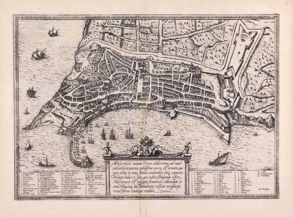
Ancona Civitas Piceni Celeberrima, ad Mare Adriaticum Posita.
Item Number: 28681 Authenticity Guarantee
Category: Antique maps > Europe > Italy - Cities
Old, antique map of Ancona, by Georg Braun & Frans Hogenberg.
Title: Ancona Civitas Piceni Celeberrima, ad Mare Adriaticum Posita.
Cum Privilegio.
Date of the first edition: 1572.
Date of this map: 1582.
Copper engraving, printed on paper.
Map size: 340 x 480mm (13.39 x 18.9 inches).
Sheet size: 410 x 535mm (16.14 x 21.06 inches).
Verso: German text.
Condition: Excellent.
Condition Rating: A+.
From: Beschreibung und Contrafactur der vornembster Stät der Welt. [Part 1] Cologne, Gottfried von Kempen, 1582. (Van der Krogt 4, 41:2.1)
TRANSLATION OF CARTOUCHE TEXT: Ancona, a famous city in Picenum on the Adriatic, is embellished by a most excellent harbour: there is namely none more commodious or spacious in all of Italy. It takes its name from its location, which resembles the crook of an elbow. It is famed for its trade and has an abundance of grain and wine and all other necessities of life: it is redolent everywhere of great age.
COMMENTARY BY BRAUN: "Ancona lies on a promontory that runs down to the Adriatic. And as Pliny and Pomponius Mela testify, it is called Ancona, or in Greek Ancon, due to its shape, which looks like a bent elbow. This city has a convenient, magnificent and large harbour, the likes of which are not to be found anywhere else in Italy. The harbour is naturally situated and is well fortified by human skill against all attacks by enemies; hence not by chance the saying: "Only in Rome is there St Peter's, only in Cremona a tower and only in Ancona a harbour."
Ancona is seen here from Adriatic in bird's-eye view. The curved natural harbour full of ships in front of the city and the well-ordered fields on the hills behind are particularly evident. On a rocky promontory on the far left lies the Romanesque cathedral of San Ciriaco (1), which dominates the city and the port. The city's notable Gothic churches include San Francesco which is an attached monastery (15, left) and San Agostino (32, centre). (Taschen)
Braun G. & Hogenberg F. and the Civitates Orbis Terrarum.
The Civitates Orbis Terrarum, also known as the 'Braun & Hogenberg', is a six-volume town atlas and the most excellent book of town views and plans ever published: 363 engravings, sometimes beautifully coloured. It was one of the best-selling works in the last quarter of the 16th century. Georg Braun, a skilled writer, wrote the text accompanying the plans and views on the verso. Many plates were engraved after the original drawings of a professional artist, Joris Hoefnagel (1542-1600). The first volume was published in Latin in 1572 and the sixth in 1617. Frans Hogenberg, a talented engraver, created the tables for volumes I through IV, and Simon van den Neuwel made those for volumes V and VI. Other contributors were cartographers Daniel Freese and Heinrich Rantzau, who provided valuable geographical information. Works by Jacob van Deventer, Sebastian Münster, and Johannes Stumpf were also used as references. Translations appeared in German and French, making the atlas accessible to a broader audience.
Since its original publication of volume 1 in 1572, the Civitates Orbis Terrarum has left an indelible mark on the history of cartography. Seven more editions followed the first volume in 1575, 1577, 1582, 1588, 1593, 1599, and 1612. Vol.2, initially released in 1575, saw subsequent editions in 1597 and 1612. The subsequent volumes, each a treasure trove of historical insights, graced the world in 1581, 1588, 1593, 1599, and 1606. The German translation of the first volume, a testament to its widespread appeal, debuted in 1574, followed by the French edition in 1575.
Several printers were involved: Theodor Graminaeus, Heinrich von Aich, Gottfried von Kempen, Johannis Sinniger, Bertram Buchholtz, and Peter von Brachel, all of whom worked in Cologne.
Georg Braun (1541-1622)
Georg Braun, the author of the text accompanying the plans and views in the Civitates Orbis Terrarum, was born in Cologne in 1541. After his studies in Cologne, he entered the Jesuit Order as a novice, indicating his commitment to learning and intellectual pursuits. In 1561, he obtained his bachelor's degree; in 1562, he received his Magister Artium, further demonstrating his academic achievements. Although he left the Jesuit Order, he continued his studies in theology, gaining a licentiate in theology. His theological background likely influenced the content and tone of the text in the Civitates Orbis Terrarum, adding a unique perspective to the work.
Frans Hogenberg (1535-1590)
Frans Hogenberg was a Flemish and German painter, engraver, and mapmaker. He was born in Mechelen as the son of Nicolaas Hogenberg.
By the end of the 1560s, Frans Hogenberg was employed upon Abraham Ortelius's Theatrum Orbis Terrarum, published in 1570; he is named an engraver of numerous maps. In 1568, he was banned from Antwerp by the Duke of Alva and travelled to London, where he stayed a few years before emigrating to Cologne. He immediately embarked on his two most important works, the Civitates, published in 1572 and the Geschichtsblätter, which appeared in several series from 1569 until about 1587.
Thanks to large-scale projects like the Geschichtsblätter and the Civitates, Hogenberg's social circumstances improved with each passing year. He died as a wealthy man in Cologne in 1590.