
Terracina by Braun and Hogenberg after G. Hoefnagel. 1623


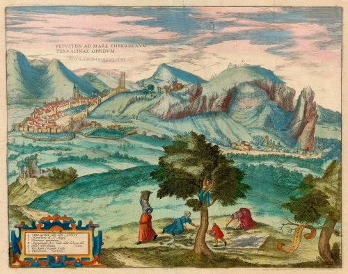


TRANSLATION OF CAPTION: The ancient town of Terracina on the Tyrrhenian Sea.
COMMENTARY BY BRAUN: "Terracina is an ancient city in Latium surrounded by the sea in earlier times. It stood originally on a hill surrounded by valleys filled with seawater. But since these valleys have been filled with earth, the hill is now on the mainland, and the city stretches to the coast. The Via Appia that leads from Rome to Brindisi passes by Terracina, but at the present time, it is flooded by marsh water."
This is a view from the northwest of the city of Terracina, which is situated on a steep hillside. The cathedral of San Cesareo (A) can be seen inside the city wall and, on the right, on a hill outside the walls, the monastery of Sant'Angelo (B). On the top of Mount Sant'Angelo is an ancient building known as the Theatrum quadratum (C). This is the temple of Jupiter Anxur, dating from the 1st century BC. In antiquity, Terracina was called Anxur and was a prosperous city, especially after the Via Appia (F) was built nearby in 312 BC. It battled with malaria until the draining of the Pontine Marshes at the beginning of the 20th century. In this plate, Hoefnagel has documented the time of the almond harvest, which is shown in the foreground. (Taschen)
Braun G. & Hogenberg F. and the Civitates Orbis Terrarum.
The Civitates Orbis Terrarum, also known as the 'Braun & Hogenberg', is a six-volume town atlas and the most excellent book of town views and plans ever published: 363 engravings, sometimes beautifully coloured. It was one of the best-selling works in the last quarter of the 16th century. Georg Braun, a skilled writer, wrote the text accompanying the plans and views on the verso. Many plates were engraved after the original drawings of a professional artist, Joris Hoefnagel (1542-1600). The first volume was published in Latin in 1572 and the sixth in 1617. Frans Hogenberg, a talented engraver, created the tables for volumes I through IV, and Simon van den Neuwel made those for volumes V and VI. Other contributors were cartographers Daniel Freese and Heinrich Rantzau, who provided valuable geographical information. Works by Jacob van Deventer, Sebastian Münster, and Johannes Stumpf were also used as references. Translations appeared in German and French, making the atlas accessible to a broader audience.
Since its original publication of volume 1 in 1572, the Civitates Orbis Terrarum has left an indelible mark on the history of cartography. Seven more editions followed the first volume in 1575, 1577, 1582, 1588, 1593, 1599, and 1612. Vol.2, initially released in 1575, saw subsequent editions in 1597 and 1612. The subsequent volumes, each a treasure trove of historical insights, graced the world in 1581, 1588, 1593, 1599, and 1606. The German translation of the first volume, a testament to its widespread appeal, debuted in 1574, followed by the French edition in 1575.
Several printers were involved: Theodor Graminaeus, Heinrich von Aich, Gottfried von Kempen, Johannis Sinniger, Bertram Buchholtz, and Peter von Brachel, all of whom worked in Cologne.
Georg Braun (1541-1622)
Georg Braun, the author of the text accompanying the plans and views in the Civitates Orbis Terrarum, was born in Cologne in 1541. After his studies in Cologne, he entered the Jesuit Order as a novice, indicating his commitment to learning and intellectual pursuits. In 1561, he obtained his bachelor's degree; in 1562, he received his Magister Artium, further demonstrating his academic achievements. Although he left the Jesuit Order, he continued his studies in theology, gaining a licentiate in theology. His theological background likely influenced the content and tone of the text in the Civitates Orbis Terrarum, adding a unique perspective to the work.
Frans Hogenberg (1535-1590)
Frans Hogenberg was a Flemish and German painter, engraver, and mapmaker. He was born in Mechelen as the son of Nicolaas Hogenberg.
By the end of the 1560s, Frans Hogenberg was employed upon Abraham Ortelius's Theatrum Orbis Terrarum, published in 1570; he is named an engraver of numerous maps. In 1568, he was banned from Antwerp by the Duke of Alva and travelled to London, where he stayed a few years before emigrating to Cologne. He immediately embarked on his two most important works, the Civitates, published in 1572 and the Geschichtsblätter, which appeared in several series from 1569 until about 1587.
Thanks to large-scale projects like the Geschichtsblätter and the Civitates, Hogenberg's social circumstances improved with each passing year. He died as a wealthy man in Cologne in 1590.
Vetustiss. Ad Mare Thyrrhenum Terracinae Oppidum
Item Number: 23334 Authenticity Guarantee
Category: Antique maps > Europe > Italy - Cities
Terracina by Braun and Hogenberg after G. Hoefnagel.
Title: Vetustiss. Ad Mare Thyrrhenum Terracinae Oppidum.
Date of the first edition: 1581.
Date of this map: 1623.
Copper engraving, printed on paper.
Size (not including margins): 330 x 425mm (12.99 x 16.73 inches).
Verso: Latin text.
Condition: Excellent, superb old colour.
Condition Rating: A.
From: Civitates Orbis Terrarum. - Urbium Praeciuarum Totius Mundi Liber Terius. Cologne, Petrus von Brachel, 1623. (Van der Krogt 4, 41:1.3)
TRANSLATION OF CAPTION: The ancient town of Terracina on the Tyrrhenian Sea.
COMMENTARY BY BRAUN: "Terracina is an ancient city in Latium surrounded by the sea in earlier times. It stood originally on a hill surrounded by valleys filled with seawater. But since these valleys have been filled with earth, the hill is now on the mainland, and the city stretches to the coast. The Via Appia that leads from Rome to Brindisi passes by Terracina, but at the present time, it is flooded by marsh water."
This is a view from the northwest of the city of Terracina, which is situated on a steep hillside. The cathedral of San Cesareo (A) can be seen inside the city wall and, on the right, on a hill outside the walls, the monastery of Sant'Angelo (B). On the top of Mount Sant'Angelo is an ancient building known as the Theatrum quadratum (C). This is the temple of Jupiter Anxur, dating from the 1st century BC. In antiquity, Terracina was called Anxur and was a prosperous city, especially after the Via Appia (F) was built nearby in 312 BC. It battled with malaria until the draining of the Pontine Marshes at the beginning of the 20th century. In this plate, Hoefnagel has documented the time of the almond harvest, which is shown in the foreground. (Taschen)
Braun G. & Hogenberg F. and the Civitates Orbis Terrarum.
The Civitates Orbis Terrarum, also known as the 'Braun & Hogenberg', is a six-volume town atlas and the most excellent book of town views and plans ever published: 363 engravings, sometimes beautifully coloured. It was one of the best-selling works in the last quarter of the 16th century. Georg Braun, a skilled writer, wrote the text accompanying the plans and views on the verso. Many plates were engraved after the original drawings of a professional artist, Joris Hoefnagel (1542-1600). The first volume was published in Latin in 1572 and the sixth in 1617. Frans Hogenberg, a talented engraver, created the tables for volumes I through IV, and Simon van den Neuwel made those for volumes V and VI. Other contributors were cartographers Daniel Freese and Heinrich Rantzau, who provided valuable geographical information. Works by Jacob van Deventer, Sebastian Münster, and Johannes Stumpf were also used as references. Translations appeared in German and French, making the atlas accessible to a broader audience.
Since its original publication of volume 1 in 1572, the Civitates Orbis Terrarum has left an indelible mark on the history of cartography. Seven more editions followed the first volume in 1575, 1577, 1582, 1588, 1593, 1599, and 1612. Vol.2, initially released in 1575, saw subsequent editions in 1597 and 1612. The subsequent volumes, each a treasure trove of historical insights, graced the world in 1581, 1588, 1593, 1599, and 1606. The German translation of the first volume, a testament to its widespread appeal, debuted in 1574, followed by the French edition in 1575.
Several printers were involved: Theodor Graminaeus, Heinrich von Aich, Gottfried von Kempen, Johannis Sinniger, Bertram Buchholtz, and Peter von Brachel, all of whom worked in Cologne.
Georg Braun (1541-1622)
Georg Braun, the author of the text accompanying the plans and views in the Civitates Orbis Terrarum, was born in Cologne in 1541. After his studies in Cologne, he entered the Jesuit Order as a novice, indicating his commitment to learning and intellectual pursuits. In 1561, he obtained his bachelor's degree; in 1562, he received his Magister Artium, further demonstrating his academic achievements. Although he left the Jesuit Order, he continued his studies in theology, gaining a licentiate in theology. His theological background likely influenced the content and tone of the text in the Civitates Orbis Terrarum, adding a unique perspective to the work.
Frans Hogenberg (1535-1590)
Frans Hogenberg was a Flemish and German painter, engraver, and mapmaker. He was born in Mechelen as the son of Nicolaas Hogenberg.
By the end of the 1560s, Frans Hogenberg was employed upon Abraham Ortelius's Theatrum Orbis Terrarum, published in 1570; he is named an engraver of numerous maps. In 1568, he was banned from Antwerp by the Duke of Alva and travelled to London, where he stayed a few years before emigrating to Cologne. He immediately embarked on his two most important works, the Civitates, published in 1572 and the Geschichtsblätter, which appeared in several series from 1569 until about 1587.
Thanks to large-scale projects like the Geschichtsblätter and the Civitates, Hogenberg's social circumstances improved with each passing year. He died as a wealthy man in Cologne in 1590.
Related items
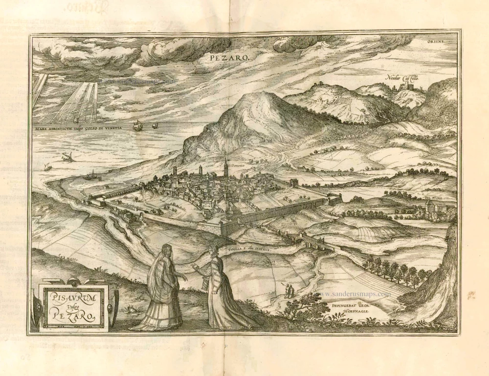
Pisaurum Vulgo Pezaro. 1582
Pesaro by Braun & Hogenberg.
[Item number: 14164]

Tridentum. Trient. 1599
Trente (Trento) by Georg Braun & Frans Hogenberg
[Item number: 24063]

Novara Mediolanensis Ducatus Civitas c. 1625
Novara by Braun and Hogenberg.
[Item number: 24530]