Palermo by Georg Braun and Frans Hogenberg, published by J. Janssonius. 1657
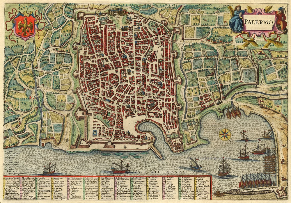
COMMENTARY BY BRAUN: "Then, on the highest point in the city to the west, is a splendid castle called the Palace of the Norman Kings (72). It is built of vast hewn stones, and in many places, it has Parian marble. It is also very ornately embellished with gold and pearls. To the right of its entrance is the church of St Peter, built by Roger, King of Sicily, which, because of its beauty and the exquisiteness of its decoration, surpasses all other extant Italian churches in our day, be they old or new, and, therefore, is visited by everyone with great admiration and great pleasure, both those who are wise, good and learned as well as the bad and the ignorant, who live in Palermo or are merely visiting."
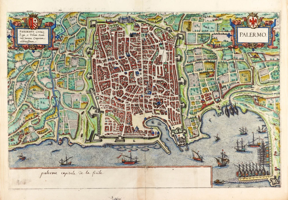
From a bird's-eye perspective, the port city of Palermo is seen here from the northeast. Nestled in a fertile plain amidst lemon and orange groves, it is fortified against attack by what were then state-of-the-art fortifications. Palermo, a major port, is depicted with the Old Town harbour and the extensive new port, where galleys lie at anchor, their oars stationary. Founded by the Phoenicians and later conquered by the Arabs, Palermo became one of the world's largest cities from the 10th to the 11th century. Despite the disappearance of Arab influence, the city's rich history is still evident in its maze of alleys. After the Norman conquest in 1072, Palermo flourished in the 12th century as the capital of the Kingdom of Sicily, reaching its zenith under Frederick II, the Holy Roman Emperor. The 9th-century summer seat of the Emir of Palermo was transformed into the Norman palace (72) in the 12th century. Palermo's importance waned under changing rules, but it remains the capital of the Italian province and Sicily's autonomous region today.
The Janssonius Family
Joannes Janssonius (Arnhem, 1588-1664), son of the Arnhem publisher Jan Janssen, married Elisabeth Hondius, daughter of Jodocus Hondius, in Amsterdam in 1612. After his marriage, he settled down in this town as a bookseller and publisher of cartographic material. In 1618, he established himself in Amsterdam next door to Blaeu’s bookshop. He entered into serious competition with Willem Jansz. Blaeu when copying Blaeu’s Licht der Zeevaert after the expiration of the privilege in 1620. His activities concerned the publication of atlases, books, single maps, and an extensive book trade with branches in Frankfurt, Danzig, Stockholm, Copenhagen, Berlin, Koningsbergen, Geneva, and Lyon. In 1631, he began publishing atlases together with Henricus Hondius.
In the early 1640s, Henricus Hondius left the atlas publishing business to Janssonius. Competition with Joan Blaeu, Willem’s son and successor, in atlas production, prompted Janssonius to enlarge his Atlas Novus finally into a work of six volumes, into which a sea atlas and an atlas of the Old World were inserted. Other atlases published by Janssonius are Mercator’s Atlas Minor, Hornius’s historical atlas (1652), the townbooks in eight volumes (1657), Cellarius’s Atlas Coelestis and several sea atlases and pilot guides.
After the death of Joannes Janssonius, the shop and publishing firm were continued by the heirs under the direction of Johannes van Waesbergen (c. 1616-1681), son-in-law of Joannes Janssonius. Van Waesbergen added Janssonius's name to his own.
In 1676, Joannes Janssonius’s heirs sold by auction “all the remaining Atlases in Latin, French, High and Low German, as well as the Stedeboecken in Latin, in 8 volumes, bound and unbound, maps, plates belonging to the Atlas and Stedeboecken.” The copperplates from Janssonius’s atlases were afterwards sold to Schenk and Valck.
Palermo
Currently not available
Item Number: 19337 Authenticity Guarantee
Category: Antique maps > Europe > Italy - Cities
Palermo by J. Janssonius, after Georg Braun and Frans Hogenberg.
Title: Palermo.
Date of the first edition: 1588 (Br & Hog. 1st state).
Date of this map: 1657.
Copper engraving, printed on paper.
Size (not including margins): 325 x 465mm (12.8 x 18.31 inches).
Verso: Latin text.
Condition: Original coloured, excellent.
Condition Rating: A+.
From: Theatrum Celebriorum Urbium Italiae, Aliarumque In Insulis Maris Mediterranei. Amsterdam, J. Janssonius, 1657. (Van der Krogt 4, 42:15)
COMMENTARY BY BRAUN: "Then, on the highest point in the city to the west, is a splendid castle called the Palace of the Norman Kings (72). It is built of vast hewn stones, and in many places, it has Parian marble. It is also very ornately embellished with gold and pearls. To the right of its entrance is the church of St Peter, built by Roger, King of Sicily, which, because of its beauty and the exquisiteness of its decoration, surpasses all other extant Italian churches in our day, be they old or new, and, therefore, is visited by everyone with great admiration and great pleasure, both those who are wise, good and learned as well as the bad and the ignorant, who live in Palermo or are merely visiting."
From a bird's-eye perspective, the port city of Palermo is seen here from the northeast. Nestled in a fertile plain amidst lemon and orange groves, it is fortified against attack by what were then state-of-the-art fortifications. Palermo, a major port, is depicted with the Old Town harbour and the extensive new port, where galleys lie at anchor, their oars stationary. Founded by the Phoenicians and later conquered by the Arabs, Palermo became one of the world's largest cities from the 10th to the 11th century. Despite the disappearance of Arab influence, the city's rich history is still evident in its maze of alleys. After the Norman conquest in 1072, Palermo flourished in the 12th century as the capital of the Kingdom of Sicily, reaching its zenith under Frederick II, the Holy Roman Emperor. The 9th-century summer seat of the Emir of Palermo was transformed into the Norman palace (72) in the 12th century. Palermo's importance waned under changing rules, but it remains the capital of the Italian province and Sicily's autonomous region today.
The Janssonius Family
Joannes Janssonius (Arnhem, 1588-1664), son of the Arnhem publisher Jan Janssen, married Elisabeth Hondius, daughter of Jodocus Hondius, in Amsterdam in 1612. After his marriage, he settled down in this town as a bookseller and publisher of cartographic material. In 1618, he established himself in Amsterdam next door to Blaeu’s bookshop. He entered into serious competition with Willem Jansz. Blaeu when copying Blaeu’s Licht der Zeevaert after the expiration of the privilege in 1620. His activities concerned the publication of atlases, books, single maps, and an extensive book trade with branches in Frankfurt, Danzig, Stockholm, Copenhagen, Berlin, Koningsbergen, Geneva, and Lyon. In 1631, he began publishing atlases together with Henricus Hondius.
In the early 1640s, Henricus Hondius left the atlas publishing business to Janssonius. Competition with Joan Blaeu, Willem’s son and successor, in atlas production, prompted Janssonius to enlarge his Atlas Novus finally into a work of six volumes, into which a sea atlas and an atlas of the Old World were inserted. Other atlases published by Janssonius are Mercator’s Atlas Minor, Hornius’s historical atlas (1652), the townbooks in eight volumes (1657), Cellarius’s Atlas Coelestis and several sea atlases and pilot guides.
After the death of Joannes Janssonius, the shop and publishing firm were continued by the heirs under the direction of Johannes van Waesbergen (c. 1616-1681), son-in-law of Joannes Janssonius. Van Waesbergen added Janssonius's name to his own.
In 1676, Joannes Janssonius’s heirs sold by auction “all the remaining Atlases in Latin, French, High and Low German, as well as the Stedeboecken in Latin, in 8 volumes, bound and unbound, maps, plates belonging to the Atlas and Stedeboecken.” The copperplates from Janssonius’s atlases were afterwards sold to Schenk and Valck.


