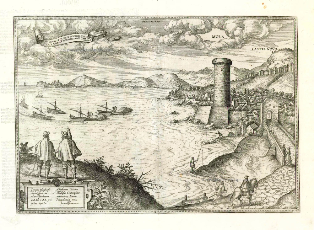
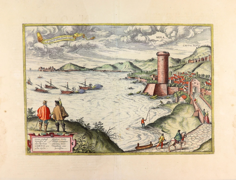
Gulf of Gaeta with Mola and Castel Novo by Georg Braun & Frans Hogenberg. 1581


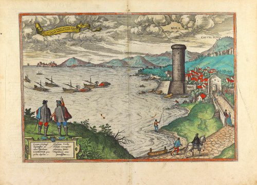

TRANSLATION OF CARTOUCHE TEXT: Georg Hoefnagel, painter of this fine view of Cape Gaeta on the Tyrrhenian Sea. Abraham Ortelius, a keen observer and admirer, was an extremely agreeable travelling companion on the journey to Naples.
COMMENTARY BY BRAUN (on verso): "Mola is an elongated and wonderful town in Latium on the Via Appia. The town is truly charming, full of the most well-tended gardens with lemons, limes and fine groves. Through them flow little streams with the purest water; as a luxury, they even flow right up to the houses. [...] Gaeta is excellently fortified and possesses an impregnable castle perched on top of the hill, around which a wall was built by Ferdinand II, King of Aragon and Naples, many years ago. [...] It is common knowledge that Gaeta has been reduced to ruins more than once. It suffered a terrible defeat in 1394 when the French decimated the town, with much bloodshed among the population."
This is a sweeping view of the Gulf of Gaeta, the town of the same name (left background), Formia (right foreground, formerly Mola di Gaeta) and the Via Appia. In the left foreground are Ortelius and Hoefnagel. They associate the name Gaeta with Aeneas's nurse, and Ortelius is pointing at the caption in the upper left-hand corner: "You too, Caieta, nurse of Aeneas, have given by your death eternal fame to our shores" (Virgil, Aeneid VII, 1-2). Gaeta is considered to be one of the oldest towns in Italy. It belonged to the Papal States and is today still an episcopal see. In 1435 King Alfonso V of Aragon captured Gaeta and built the castle seen in the distance. A massive round tower guards Formia, the Torre di Mola, and is dominated by a fortress from the late Middle Ages. Like many towns in this region, Gaeta was a popular summer resort for the Romans, and it was granted Roman city rights in 338 BC. (Taschen)
Braun G. & Hogenberg F. and the Civitates Orbis Terrarum.
The Civitates Orbis Terrarum, also known as the 'Braun & Hogenberg', is a six-volume town atlas and the most excellent book of town views and plans ever published: 363 engravings, sometimes beautifully coloured. It was one of the best-selling works in the last quarter of the 16th century. Georg Braun, a skilled writer, wrote the text accompanying the plans and views on the verso. Many plates were engraved after the original drawings of a professional artist, Joris Hoefnagel (1542-1600). The first volume was published in Latin in 1572 and the sixth in 1617. Frans Hogenberg, a talented engraver, created the tables for volumes I through IV, and Simon van den Neuwel made those for volumes V and VI. Other contributors were cartographers Daniel Freese and Heinrich Rantzau, who provided valuable geographical information. Works by Jacob van Deventer, Sebastian Münster, and Johannes Stumpf were also used as references. Translations appeared in German and French, making the atlas accessible to a broader audience.
Since its original publication of volume 1 in 1572, the Civitates Orbis Terrarum has left an indelible mark on the history of cartography. Seven more editions followed the first volume in 1575, 1577, 1582, 1588, 1593, 1599, and 1612. Vol.2, initially released in 1575, saw subsequent editions in 1597 and 1612. The subsequent volumes, each a treasure trove of historical insights, graced the world in 1581, 1588, 1593, 1599, and 1606. The German translation of the first volume, a testament to its widespread appeal, debuted in 1574, followed by the French edition in 1575.
Several printers were involved: Theodor Graminaeus, Heinrich von Aich, Gottfried von Kempen, Johannis Sinniger, Bertram Buchholtz, and Peter von Brachel, all of whom worked in Cologne.
Georg Braun (1541-1622)
Georg Braun, the author of the text accompanying the plans and views in the Civitates Orbis Terrarum, was born in Cologne in 1541. After his studies in Cologne, he entered the Jesuit Order as a novice, indicating his commitment to learning and intellectual pursuits. In 1561, he obtained his bachelor's degree; in 1562, he received his Magister Artium, further demonstrating his academic achievements. Although he left the Jesuit Order, he continued his studies in theology, gaining a licentiate in theology. His theological background likely influenced the content and tone of the text in the Civitates Orbis Terrarum, adding a unique perspective to the work.
Frans Hogenberg (1535-1590)
Frans Hogenberg was a Flemish and German painter, engraver, and mapmaker. He was born in Mechelen as the son of Nicolaas Hogenberg.
By the end of the 1560s, Frans Hogenberg was employed upon Abraham Ortelius's Theatrum Orbis Terrarum, published in 1570; he is named an engraver of numerous maps. In 1568, he was banned from Antwerp by the Duke of Alva and travelled to London, where he stayed a few years before emigrating to Cologne. He immediately embarked on his two most important works, the Civitates, published in 1572 and the Geschichtsblätter, which appeared in several series from 1569 until about 1587.
Thanks to large-scale projects like the Geschichtsblätter and the Civitates, Hogenberg's social circumstances improved with each passing year. He died as a wealthy man in Cologne in 1590.
Mola - Castel Novo.
Item Number: 25427 Authenticity Guarantee
Category: Antique maps > Europe > Italy - Cities
Old, antique bird’s-eye view of the Gulf of Gaeta with Mola and Castel Novo by Georg Braun & Frans Hogenberg.
Title: Mola - Castel Novo.
Date of the first edition: 1581.
Date of this map: 1581.
Copper engraving, printed on paper.
Image size: 300 x 430mm (11.81 x 16.93 inches).
Sheet size: 380 x 510mm (14.96 x 20.08 inches).
Verso: Latin text.
Condition: Original coloured, excellent.
Condition Rating: A+.
From: Civitates Orbis Terrarum. . Liber tertius. Cologne, Gottfried von Kempen, 1581. (Van der Krogt 4, 41:1.3)
TRANSLATION OF CARTOUCHE TEXT: Georg Hoefnagel, painter of this fine view of Cape Gaeta on the Tyrrhenian Sea. Abraham Ortelius, a keen observer and admirer, was an extremely agreeable travelling companion on the journey to Naples.
COMMENTARY BY BRAUN (on verso): "Mola is an elongated and wonderful town in Latium on the Via Appia. The town is truly charming, full of the most well-tended gardens with lemons, limes and fine groves. Through them flow little streams with the purest water; as a luxury, they even flow right up to the houses. [...] Gaeta is excellently fortified and possesses an impregnable castle perched on top of the hill, around which a wall was built by Ferdinand II, King of Aragon and Naples, many years ago. [...] It is common knowledge that Gaeta has been reduced to ruins more than once. It suffered a terrible defeat in 1394 when the French decimated the town, with much bloodshed among the population."
This is a sweeping view of the Gulf of Gaeta, the town of the same name (left background), Formia (right foreground, formerly Mola di Gaeta) and the Via Appia. In the left foreground are Ortelius and Hoefnagel. They associate the name Gaeta with Aeneas's nurse, and Ortelius is pointing at the caption in the upper left-hand corner: "You too, Caieta, nurse of Aeneas, have given by your death eternal fame to our shores" (Virgil, Aeneid VII, 1-2). Gaeta is considered to be one of the oldest towns in Italy. It belonged to the Papal States and is today still an episcopal see. In 1435 King Alfonso V of Aragon captured Gaeta and built the castle seen in the distance. A massive round tower guards Formia, the Torre di Mola, and is dominated by a fortress from the late Middle Ages. Like many towns in this region, Gaeta was a popular summer resort for the Romans, and it was granted Roman city rights in 338 BC. (Taschen)
Braun G. & Hogenberg F. and the Civitates Orbis Terrarum.
The Civitates Orbis Terrarum, also known as the 'Braun & Hogenberg', is a six-volume town atlas and the most excellent book of town views and plans ever published: 363 engravings, sometimes beautifully coloured. It was one of the best-selling works in the last quarter of the 16th century. Georg Braun, a skilled writer, wrote the text accompanying the plans and views on the verso. Many plates were engraved after the original drawings of a professional artist, Joris Hoefnagel (1542-1600). The first volume was published in Latin in 1572 and the sixth in 1617. Frans Hogenberg, a talented engraver, created the tables for volumes I through IV, and Simon van den Neuwel made those for volumes V and VI. Other contributors were cartographers Daniel Freese and Heinrich Rantzau, who provided valuable geographical information. Works by Jacob van Deventer, Sebastian Münster, and Johannes Stumpf were also used as references. Translations appeared in German and French, making the atlas accessible to a broader audience.
Since its original publication of volume 1 in 1572, the Civitates Orbis Terrarum has left an indelible mark on the history of cartography. Seven more editions followed the first volume in 1575, 1577, 1582, 1588, 1593, 1599, and 1612. Vol.2, initially released in 1575, saw subsequent editions in 1597 and 1612. The subsequent volumes, each a treasure trove of historical insights, graced the world in 1581, 1588, 1593, 1599, and 1606. The German translation of the first volume, a testament to its widespread appeal, debuted in 1574, followed by the French edition in 1575.
Several printers were involved: Theodor Graminaeus, Heinrich von Aich, Gottfried von Kempen, Johannis Sinniger, Bertram Buchholtz, and Peter von Brachel, all of whom worked in Cologne.
Georg Braun (1541-1622)
Georg Braun, the author of the text accompanying the plans and views in the Civitates Orbis Terrarum, was born in Cologne in 1541. After his studies in Cologne, he entered the Jesuit Order as a novice, indicating his commitment to learning and intellectual pursuits. In 1561, he obtained his bachelor's degree; in 1562, he received his Magister Artium, further demonstrating his academic achievements. Although he left the Jesuit Order, he continued his studies in theology, gaining a licentiate in theology. His theological background likely influenced the content and tone of the text in the Civitates Orbis Terrarum, adding a unique perspective to the work.
Frans Hogenberg (1535-1590)
Frans Hogenberg was a Flemish and German painter, engraver, and mapmaker. He was born in Mechelen as the son of Nicolaas Hogenberg.
By the end of the 1560s, Frans Hogenberg was employed upon Abraham Ortelius's Theatrum Orbis Terrarum, published in 1570; he is named an engraver of numerous maps. In 1568, he was banned from Antwerp by the Duke of Alva and travelled to London, where he stayed a few years before emigrating to Cologne. He immediately embarked on his two most important works, the Civitates, published in 1572 and the Geschichtsblätter, which appeared in several series from 1569 until about 1587.
Thanks to large-scale projects like the Geschichtsblätter and the Civitates, Hogenberg's social circumstances improved with each passing year. He died as a wealthy man in Cologne in 1590.