
Nocerra Umbra and Castelnuovo di Porto by Georg Braun & Frans Hogenberg. 1596
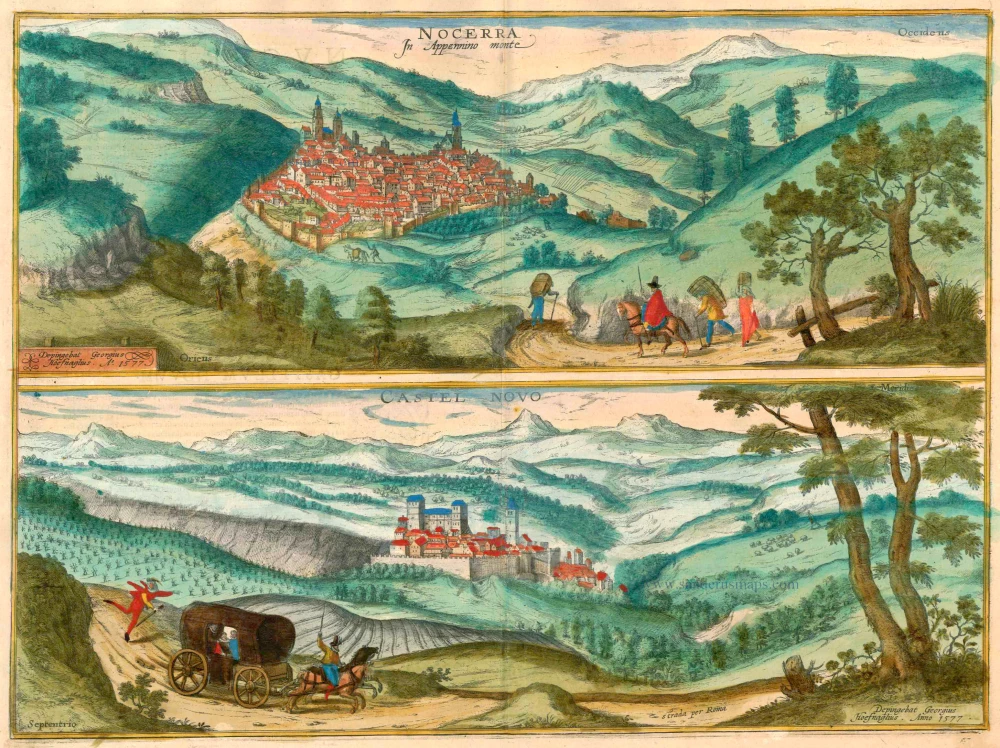


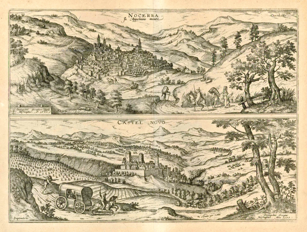
NOCERA UMBRA
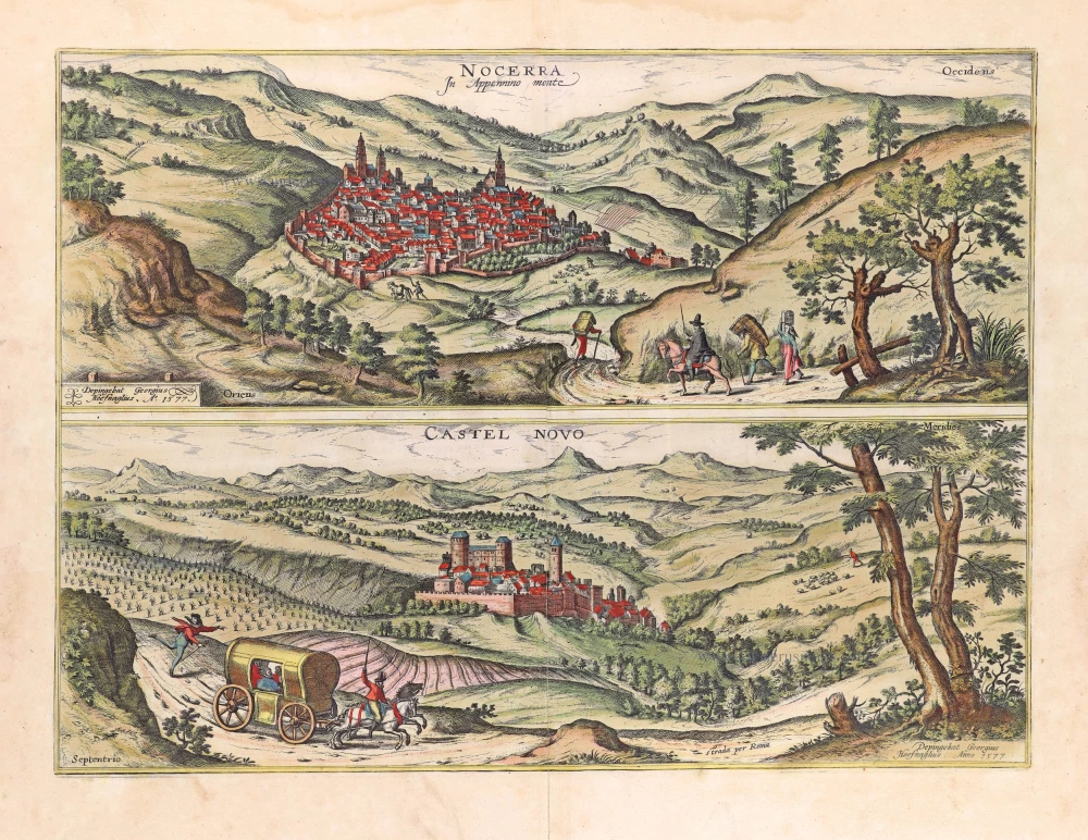
COMMENTARY BY BRAUN: "Nocera Umbra is a small town in Umbria at the foot of Monte Pennino, which Strabo called Nuceriam and is famous for its wooden barrels [...]. At the foot of the mountain on which Nocera lies, the Topino flows towards Foligno through the Topinian Valley. On the banks of the river, one can still see many ruined houses and the foundations of large buildings that were erected there by the Romans to guard the Via Flaminia."
The view shows Nocera Umbra situated on a ridge in a mountainous landscape north of Foligno. Rising at the highest point of the well-fortified town is the cathedral and the 14th-century Campanaccio tower, formerly part of the Trinci fortress. Prominent on the right is the church of San Francesco, today home to the Nocera Umbra art museum. In Roman times the town was known as Nuceria Camellaria and was of considerable importance due to its position on the Via Flaminia. In the 5th century AD, Nocera became a bishopric and formed part of the Papal States right until Italian Unification. Having been decimated on multiple occasions by the Goths, Lombards, and Emperor Frederick II in the 13th century, the town was rebuilt in the mid-15th century. Sadly, in September 1997, the historical centre of Nocera Umbra was almost destroyed by an earthquake.
CASTELNUOVO DI PORTO
COMMENTARY BY BRAUN: "Castelnuovo is a small town on the road leading toward Rome in the Apennine Mountains. The inhabitants are dynamic and experienced in the wool, wine and oil trade. Castelnuovo lies on fertile soil that yields grain, wine, oil, and other necessities. It lies 12 miles from Rome on the Via Flaminia. [...] On the same road, one can see the town of Castellana high up on a cliff [...] on the left lies Monte Soratte, which Cato, Virgil and Strabo call mons Soracte, but which is today known as St Sylvester Mount because Pope Sylvester fled there for fear of Emperor Constantine."
In the foreground, Braun and Hoefnagel are travelling by horse and carriage along the ancient Via Flaminia from Nocera Umbra in the direction of Rome, past the towns of Castelnuovo di Porto, Cività Castellana (the ancient capital of the Falisci) and Monte Soratte. Behind the ramparts, the magnificent 15th-century Palazzo Ducale dominates the town centre. Rising proudly to the right is the bell tower belonging to the collegiate church of S. Maria Assunta. The "castrum novum" is first mentioned in records in 1074 as a benefice of the patriarchal basilica of St Paul Outside the Walls in Rome. Castelnuovo acquired its epithet "di Porto" when it belonged to the diocese of Porto. According to legend, Emperor Constantine sought out Pope Sylvester (d. 31 December 335), who had taken refuge on Mount Soracte and was cured of leprosy upon receiving his Christian baptism. This episode was related to the so-called Donation of Constantine, a document that proved to be a forgery by Lorenzo Valla as early as the 15th century. From the 12th to the 16th century, with some interruptions, Castelnuovo di Porto belonged to the Roman Colonna family; in 1539, after financial difficulties, it was acquired for the Camera Apostolica by Pope Paul III. (Taschen)
Braun G. & Hogenberg F. and the Civitates Orbis Terrarum.
The Civitates Orbis Terrarum, also known as the 'Braun & Hogenberg', is a six-volume town atlas and the most excellent book of town views and plans ever published: 363 engravings, sometimes beautifully coloured. It was one of the best-selling works in the last quarter of the 16th century. Georg Braun, a skilled writer, wrote the text accompanying the plans and views on the verso. Many plates were engraved after the original drawings of a professional artist, Joris Hoefnagel (1542-1600). The first volume was published in Latin in 1572 and the sixth in 1617. Frans Hogenberg, a talented engraver, created the tables for volumes I through IV, and Simon van den Neuwel made those for volumes V and VI. Other contributors were cartographers Daniel Freese and Heinrich Rantzau, who provided valuable geographical information. Works by Jacob van Deventer, Sebastian Münster, and Johannes Stumpf were also used as references. Translations appeared in German and French, making the atlas accessible to a broader audience.
Since its original publication of volume 1 in 1572, the Civitates Orbis Terrarum has left an indelible mark on the history of cartography. Seven more editions followed the first volume in 1575, 1577, 1582, 1588, 1593, 1599, and 1612. Vol.2, initially released in 1575, saw subsequent editions in 1597 and 1612. The subsequent volumes, each a treasure trove of historical insights, graced the world in 1581, 1588, 1593, 1599, and 1606. The German translation of the first volume, a testament to its widespread appeal, debuted in 1574, followed by the French edition in 1575.
Several printers were involved: Theodor Graminaeus, Heinrich von Aich, Gottfried von Kempen, Johannis Sinniger, Bertram Buchholtz, and Peter von Brachel, all of whom worked in Cologne.
Georg Braun (1541-1622)
Georg Braun, the author of the text accompanying the plans and views in the Civitates Orbis Terrarum, was born in Cologne in 1541. After his studies in Cologne, he entered the Jesuit Order as a novice, indicating his commitment to learning and intellectual pursuits. In 1561, he obtained his bachelor's degree; in 1562, he received his Magister Artium, further demonstrating his academic achievements. Although he left the Jesuit Order, he continued his studies in theology, gaining a licentiate in theology. His theological background likely influenced the content and tone of the text in the Civitates Orbis Terrarum, adding a unique perspective to the work.
Frans Hogenberg (1535-1590)
Frans Hogenberg was a Flemish and German painter, engraver, and mapmaker. He was born in Mechelen as the son of Nicolaas Hogenberg.
By the end of the 1560s, Frans Hogenberg was employed upon Abraham Ortelius's Theatrum Orbis Terrarum, published in 1570; he is named an engraver of numerous maps. In 1568, he was banned from Antwerp by the Duke of Alva and travelled to London, where he stayed a few years before emigrating to Cologne. He immediately embarked on his two most important works, the Civitates, published in 1572 and the Geschichtsblätter, which appeared in several series from 1569 until about 1587.
Thanks to large-scale projects like the Geschichtsblätter and the Civitates, Hogenberg's social circumstances improved with each passing year. He died as a wealthy man in Cologne in 1590.
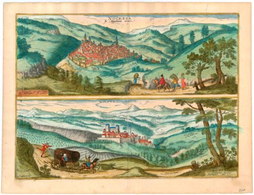
Nocerra In Appennino monte. [on sheet with] Castel Novo.
Item Number: 23400 Authenticity Guarantee
Category: Antique maps > Europe > Italy - Cities
Antique map with two views by Braun and Hogenberg: Nocerra Umbra and Castelnuovo di Porto; after G. Hoefnagel, 1577.
Title: Nocerra In Appennino monte. [on sheet with] Castel Novo.
Depingebat Georgius Hoefnaglius. Anno 1577.
Designer: Georg Hoefnagel.
Date of the first edition: 1596.
Date of this map: 1596.
Date on map: 1577.
Copper engraving, printed on paper.
Size (not including margins): 365 x 480mm (14.37 x 18.9 inches).
Verso: Latin text.
Condition: Excellent, superb old colour.
Condition Rating: A+.
References: Van der Krogt 4, 3095; Taschen, Br. Hog., p.425; Fauser, #9946 & 2399
From: Urbium Praecipuarum Mundi Theatrum Quintum Auctore Georgio Braunio Agrippinate. Part 5. Köln, 1596/97. (Van der Krogt 4, 41:1.5)
NOCERA UMBRA
COMMENTARY BY BRAUN: "Nocera Umbra is a small town in Umbria at the foot of Monte Pennino, which Strabo called Nuceriam and is famous for its wooden barrels [...]. At the foot of the mountain on which Nocera lies, the Topino flows towards Foligno through the Topinian Valley. On the banks of the river, one can still see many ruined houses and the foundations of large buildings that were erected there by the Romans to guard the Via Flaminia."
The view shows Nocera Umbra situated on a ridge in a mountainous landscape north of Foligno. Rising at the highest point of the well-fortified town is the cathedral and the 14th-century Campanaccio tower, formerly part of the Trinci fortress. Prominent on the right is the church of San Francesco, today home to the Nocera Umbra art museum. In Roman times the town was known as Nuceria Camellaria and was of considerable importance due to its position on the Via Flaminia. In the 5th century AD, Nocera became a bishopric and formed part of the Papal States right until Italian Unification. Having been decimated on multiple occasions by the Goths, Lombards, and Emperor Frederick II in the 13th century, the town was rebuilt in the mid-15th century. Sadly, in September 1997, the historical centre of Nocera Umbra was almost destroyed by an earthquake.
CASTELNUOVO DI PORTO
COMMENTARY BY BRAUN: "Castelnuovo is a small town on the road leading toward Rome in the Apennine Mountains. The inhabitants are dynamic and experienced in the wool, wine and oil trade. Castelnuovo lies on fertile soil that yields grain, wine, oil, and other necessities. It lies 12 miles from Rome on the Via Flaminia. [...] On the same road, one can see the town of Castellana high up on a cliff [...] on the left lies Monte Soratte, which Cato, Virgil and Strabo call mons Soracte, but which is today known as St Sylvester Mount because Pope Sylvester fled there for fear of Emperor Constantine."
In the foreground, Braun and Hoefnagel are travelling by horse and carriage along the ancient Via Flaminia from Nocera Umbra in the direction of Rome, past the towns of Castelnuovo di Porto, Cività Castellana (the ancient capital of the Falisci) and Monte Soratte. Behind the ramparts, the magnificent 15th-century Palazzo Ducale dominates the town centre. Rising proudly to the right is the bell tower belonging to the collegiate church of S. Maria Assunta. The "castrum novum" is first mentioned in records in 1074 as a benefice of the patriarchal basilica of St Paul Outside the Walls in Rome. Castelnuovo acquired its epithet "di Porto" when it belonged to the diocese of Porto. According to legend, Emperor Constantine sought out Pope Sylvester (d. 31 December 335), who had taken refuge on Mount Soracte and was cured of leprosy upon receiving his Christian baptism. This episode was related to the so-called Donation of Constantine, a document that proved to be a forgery by Lorenzo Valla as early as the 15th century. From the 12th to the 16th century, with some interruptions, Castelnuovo di Porto belonged to the Roman Colonna family; in 1539, after financial difficulties, it was acquired for the Camera Apostolica by Pope Paul III. (Taschen)
Braun G. & Hogenberg F. and the Civitates Orbis Terrarum.
The Civitates Orbis Terrarum, also known as the 'Braun & Hogenberg', is a six-volume town atlas and the most excellent book of town views and plans ever published: 363 engravings, sometimes beautifully coloured. It was one of the best-selling works in the last quarter of the 16th century. Georg Braun, a skilled writer, wrote the text accompanying the plans and views on the verso. Many plates were engraved after the original drawings of a professional artist, Joris Hoefnagel (1542-1600). The first volume was published in Latin in 1572 and the sixth in 1617. Frans Hogenberg, a talented engraver, created the tables for volumes I through IV, and Simon van den Neuwel made those for volumes V and VI. Other contributors were cartographers Daniel Freese and Heinrich Rantzau, who provided valuable geographical information. Works by Jacob van Deventer, Sebastian Münster, and Johannes Stumpf were also used as references. Translations appeared in German and French, making the atlas accessible to a broader audience.
Since its original publication of volume 1 in 1572, the Civitates Orbis Terrarum has left an indelible mark on the history of cartography. Seven more editions followed the first volume in 1575, 1577, 1582, 1588, 1593, 1599, and 1612. Vol.2, initially released in 1575, saw subsequent editions in 1597 and 1612. The subsequent volumes, each a treasure trove of historical insights, graced the world in 1581, 1588, 1593, 1599, and 1606. The German translation of the first volume, a testament to its widespread appeal, debuted in 1574, followed by the French edition in 1575.
Several printers were involved: Theodor Graminaeus, Heinrich von Aich, Gottfried von Kempen, Johannis Sinniger, Bertram Buchholtz, and Peter von Brachel, all of whom worked in Cologne.
Georg Braun (1541-1622)
Georg Braun, the author of the text accompanying the plans and views in the Civitates Orbis Terrarum, was born in Cologne in 1541. After his studies in Cologne, he entered the Jesuit Order as a novice, indicating his commitment to learning and intellectual pursuits. In 1561, he obtained his bachelor's degree; in 1562, he received his Magister Artium, further demonstrating his academic achievements. Although he left the Jesuit Order, he continued his studies in theology, gaining a licentiate in theology. His theological background likely influenced the content and tone of the text in the Civitates Orbis Terrarum, adding a unique perspective to the work.
Frans Hogenberg (1535-1590)
Frans Hogenberg was a Flemish and German painter, engraver, and mapmaker. He was born in Mechelen as the son of Nicolaas Hogenberg.
By the end of the 1560s, Frans Hogenberg was employed upon Abraham Ortelius's Theatrum Orbis Terrarum, published in 1570; he is named an engraver of numerous maps. In 1568, he was banned from Antwerp by the Duke of Alva and travelled to London, where he stayed a few years before emigrating to Cologne. He immediately embarked on his two most important works, the Civitates, published in 1572 and the Geschichtsblätter, which appeared in several series from 1569 until about 1587.
Thanks to large-scale projects like the Geschichtsblätter and the Civitates, Hogenberg's social circumstances improved with each passing year. He died as a wealthy man in Cologne in 1590.
Related items
Nocerra In Appennino monte [on sheet with] Castel Novo 1596
Nocerra Umbra and Castelnuovo di Porto, by Georg Braun and Frans Hogenberg.
[Item number: 24196]
Nocerra In Appennino monte. [on sheet with] Castel Novo. 1657
Nocerra Umbra and Castelnuovo di Porto by Georg Braun & Frans Hogenberg, published by J. Janssonius.
[Item number: 31049]