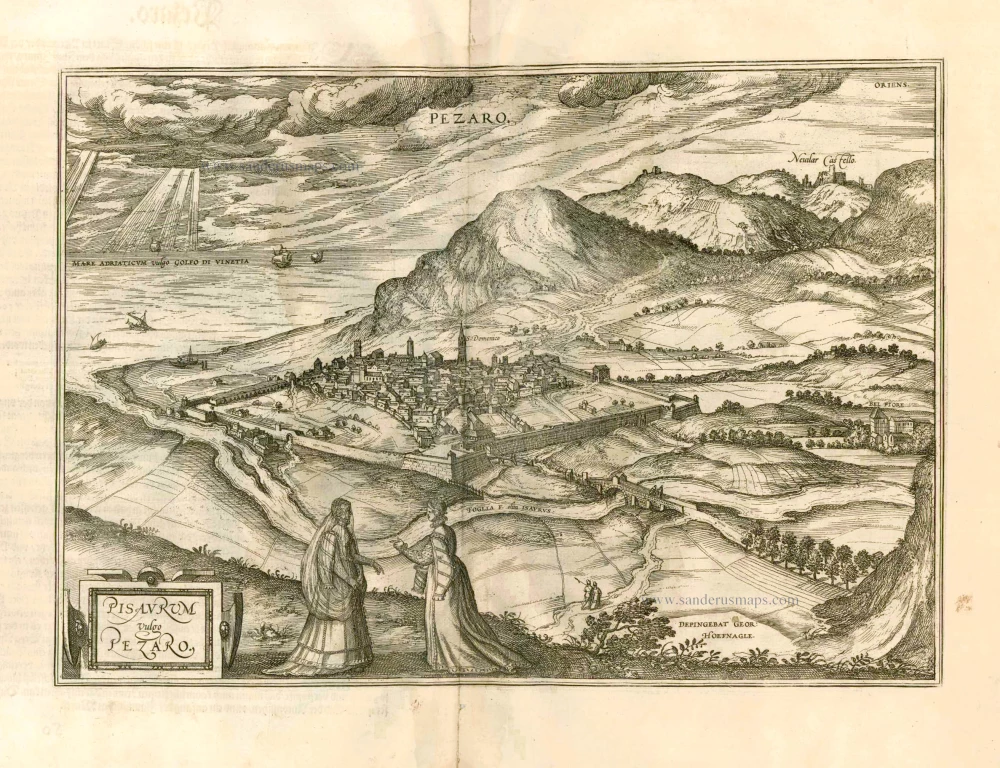
Pozzuoli by Georg Braun & Frans Hogenberg. 1599
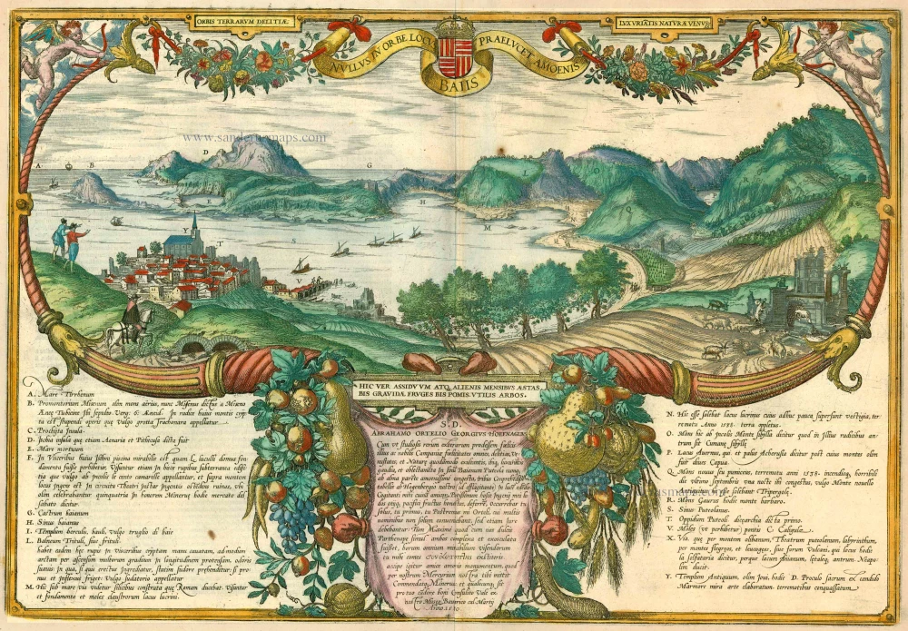
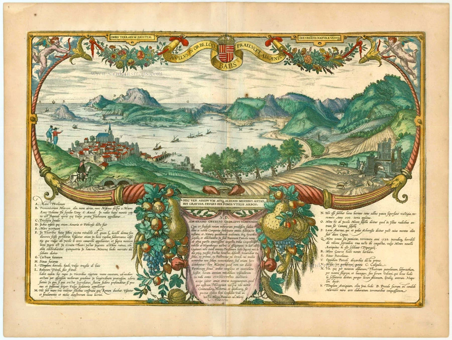


View of the town of Pozzuoli (left), its bay and in the distance the peninsula with the castle of Baia and the island of Ischia. CARTOUCHE TOP: The delights of happy Campania. CARTOUCHE BOTTOM CENTRE: Here an everlasting spring and the warmth of the remaining months produce fruits are twice as large and trees that bear twice as much fruit. Their travels led Georg Hoefnagel and his companion Ortelius (left, on a knoll) to the Gulf of Baia. Complementing the two engravings in volume II, this view is seen from an elevated point in the east and shows Pozzuoli in the foreground (T) together with the islands of Procida (C) and Ischia (D), the castle of Baia (F-G), the mountain with the Grotto of the Camaean Sybil (O), Lake Averno (P) and the temple of Jupiter (Y), flanked by curving cornucopias overflowing with the abundant gifts of nature in this climatically blessed region. The accompanying texts draw upon a knowledge of the literature of classical antiquity, for instance the remark that Cape Misenum (B) is named after Misenus, Aeneas's trumpeter, who is buried there, or the reference to natural histories, such as that of the Trituli sweat baths (L). This plate is unique in the city atlas because of its colourfulness. At the same time it is an important example of creative talents of the artist, Hoefnagel, who, in collaboration with his travelling companion Ortelius, who is again lavishly praised in the inset text (centre), augments his observations of nature with his knowledge of the classics and natural history. (Taschen)
Braun G. & Hogenberg F. and the Civitates Orbis Terrarum.
The Civitates Orbis Terrarum, also known as the 'Braun & Hogenberg', is a six-volume town atlas and the most excellent book of town views and plans ever published: 363 engravings, sometimes beautifully coloured. It was one of the best-selling works in the last quarter of the 16th century. Georg Braun, a skilled writer, wrote the text accompanying the plans and views on the verso. Many plates were engraved after the original drawings of a professional artist, Joris Hoefnagel (1542-1600). The first volume was published in Latin in 1572 and the sixth in 1617. Frans Hogenberg, a talented engraver, created the tables for volumes I through IV, and Simon van den Neuwel made those for volumes V and VI. Other contributors were cartographers Daniel Freese and Heinrich Rantzau, who provided valuable geographical information. Works by Jacob van Deventer, Sebastian Münster, and Johannes Stumpf were also used as references. Translations appeared in German and French, making the atlas accessible to a wider audience.
Since its original publication of volume 1 in 1572, the Civitates Orbis Terrarum has left an indelible mark on the history of cartography. The first volume was followed by seven more editions in 1575, 1577, 1582, 1588, 1593, 1599, and 1612. Vol.2, initially released in 1575, saw subsequent editions in 1597 and 1612. The subsequent volumes, each a treasure trove of historical insights, graced the world in 1581, 1588, 1593, 1599, and 1606. The German translation of the first volume, a testament to its widespread appeal, debuted in 1574, followed by the French edition in 1575.
Several printers were involved: Theodor Graminaeus, Heinrich von Aich, Gottfried von Kempen, Johannis Sinniger, Bertram Buchholtz, and Peter von Brachel, all of whom worked in Cologne.
Georg Braun (1541-1622)
Georg Braun, the author of the text accompanying the plans and views in the Civitates Orbis Terrarum, was born in Cologne in 1541. After his studies in Cologne, he entered the Jesuit Order as a novice, indicating his commitment to learning and intellectual pursuits. In 1561, he obtained his bachelor's degree; in 1562, he received his Magister Artium, further demonstrating his academic achievements. Although he left the Jesuit Order, he continued his studies in theology, gaining a licentiate in theology. His theological background likely influenced the content and tone of the text in the Civitates Orbis Terrarum, adding a unique perspective to the work.
Frans Hogenberg (1535-1590)
Frans Hogenberg was a Flemish and German painter, engraver, and mapmaker. He was born in Mechelen as the son of Nicolaas Hogenberg.
By the end of the 1560s, Frans Hogenberg was employed upon Abraham Ortelius's Theatrum Orbis Terrarum, published in 1570; he is named an engraver of numerous maps. In 1568, he was banned from Antwerp by the Duke of Alva and travelled to London, where he stayed a few years before emigrating to Cologne. He immediately embarked on his two most important works, the Civitates, published in 1572 and the Geschichtsblätter, which appeared in several series from 1569 until about 1587.
Thanks to large-scale projects like the Geschichtsblätter and the Civitates, Hogenberg's social circumstances improved with each passing year. He died as a wealthy man in Cologne in 1590.
Nullus in Orbe Locus Baiis Praelucet Amoenis
Item Number: 24071 Authenticity Guarantee
Category: Antique maps > Europe > Italy - Cities
Old, antique view of the town of Pozzuoli (left), its bay and in the distance the peninsula with the castle of Baia and the island of Ischia.
Vista antica della città di Pozzuoli (a sinistra), la sua baia e in lontananza la penisola con il castello di Baia e l'isola di Ischia.
CARTOUCHE TOP: The delights of happy Campania.
CARTOUCHE BOTTOM CENTRE: Here an everlasting spring and the warmth of the remaining months produce fruits are twice as large and trees that bear twice as much fruit.
Their travels led Georg Hoefnagel and his companion Ortelius (left, on a knoll) to the Gulf of Baia. Complementing the two engravings in volume II, this view is seen from an elevated point in the east and shows Pozzuoli in the foreground (T) together with the islands of Procida (C) and Ischia (D), the castle of Baia (F-G), the mountain with the Grotto of the Camaean Sybil (O), Lake Averno (P) and the temple of Jupiter (Y), flanked by curving cornucopias overflowing with the abundant gifts of nature in this climatically blessed region. The accompanying texts draw upon a knowledge of the literature of classical antiquity, for instance the remark that Cape Misenum (B) is named after Misenus, Aeneas's trumpeter, who is buried there, or the reference to natural histories, such as that of the Trituli sweat baths (L). This plate is unique in the city atlas because of its colourfulness. At the same time it is an important example of creative talents of the artist, Hoefnagel, who, in collaboration with his travelling companion Ortelius, who is again lavishly praised in the inset text (centre), augments his observations of nature with his knowledge of the classics and natural history. (Taschen)
Copper engraving
Size: 33 x 48.5cm (12.9 x 18.9 inches)
Verso text: Latin
Condition: Original coloured, excellent.
Condition Rating: A
References: Van der Krogt 4, 3459; Taschen, Braun and Hogenberg, p.265.
From: Civitates Orbis Terrarum. . Liber tertius. Köln, G. Kempen, 1581-88. (Koeman, B&H3)
View of the town of Pozzuoli (left), its bay and in the distance the peninsula with the castle of Baia and the island of Ischia. CARTOUCHE TOP: The delights of happy Campania. CARTOUCHE BOTTOM CENTRE: Here an everlasting spring and the warmth of the remaining months produce fruits are twice as large and trees that bear twice as much fruit. Their travels led Georg Hoefnagel and his companion Ortelius (left, on a knoll) to the Gulf of Baia. Complementing the two engravings in volume II, this view is seen from an elevated point in the east and shows Pozzuoli in the foreground (T) together with the islands of Procida (C) and Ischia (D), the castle of Baia (F-G), the mountain with the Grotto of the Camaean Sybil (O), Lake Averno (P) and the temple of Jupiter (Y), flanked by curving cornucopias overflowing with the abundant gifts of nature in this climatically blessed region. The accompanying texts draw upon a knowledge of the literature of classical antiquity, for instance the remark that Cape Misenum (B) is named after Misenus, Aeneas's trumpeter, who is buried there, or the reference to natural histories, such as that of the Trituli sweat baths (L). This plate is unique in the city atlas because of its colourfulness. At the same time it is an important example of creative talents of the artist, Hoefnagel, who, in collaboration with his travelling companion Ortelius, who is again lavishly praised in the inset text (centre), augments his observations of nature with his knowledge of the classics and natural history. (Taschen)
Braun G. & Hogenberg F. and the Civitates Orbis Terrarum.
The Civitates Orbis Terrarum, also known as the 'Braun & Hogenberg', is a six-volume town atlas and the most excellent book of town views and plans ever published: 363 engravings, sometimes beautifully coloured. It was one of the best-selling works in the last quarter of the 16th century. Georg Braun, a skilled writer, wrote the text accompanying the plans and views on the verso. Many plates were engraved after the original drawings of a professional artist, Joris Hoefnagel (1542-1600). The first volume was published in Latin in 1572 and the sixth in 1617. Frans Hogenberg, a talented engraver, created the tables for volumes I through IV, and Simon van den Neuwel made those for volumes V and VI. Other contributors were cartographers Daniel Freese and Heinrich Rantzau, who provided valuable geographical information. Works by Jacob van Deventer, Sebastian Münster, and Johannes Stumpf were also used as references. Translations appeared in German and French, making the atlas accessible to a wider audience.
Since its original publication of volume 1 in 1572, the Civitates Orbis Terrarum has left an indelible mark on the history of cartography. The first volume was followed by seven more editions in 1575, 1577, 1582, 1588, 1593, 1599, and 1612. Vol.2, initially released in 1575, saw subsequent editions in 1597 and 1612. The subsequent volumes, each a treasure trove of historical insights, graced the world in 1581, 1588, 1593, 1599, and 1606. The German translation of the first volume, a testament to its widespread appeal, debuted in 1574, followed by the French edition in 1575.
Several printers were involved: Theodor Graminaeus, Heinrich von Aich, Gottfried von Kempen, Johannis Sinniger, Bertram Buchholtz, and Peter von Brachel, all of whom worked in Cologne.
Georg Braun (1541-1622)
Georg Braun, the author of the text accompanying the plans and views in the Civitates Orbis Terrarum, was born in Cologne in 1541. After his studies in Cologne, he entered the Jesuit Order as a novice, indicating his commitment to learning and intellectual pursuits. In 1561, he obtained his bachelor's degree; in 1562, he received his Magister Artium, further demonstrating his academic achievements. Although he left the Jesuit Order, he continued his studies in theology, gaining a licentiate in theology. His theological background likely influenced the content and tone of the text in the Civitates Orbis Terrarum, adding a unique perspective to the work.
Frans Hogenberg (1535-1590)
Frans Hogenberg was a Flemish and German painter, engraver, and mapmaker. He was born in Mechelen as the son of Nicolaas Hogenberg.
By the end of the 1560s, Frans Hogenberg was employed upon Abraham Ortelius's Theatrum Orbis Terrarum, published in 1570; he is named an engraver of numerous maps. In 1568, he was banned from Antwerp by the Duke of Alva and travelled to London, where he stayed a few years before emigrating to Cologne. He immediately embarked on his two most important works, the Civitates, published in 1572 and the Geschichtsblätter, which appeared in several series from 1569 until about 1587.
Thanks to large-scale projects like the Geschichtsblätter and the Civitates, Hogenberg's social circumstances improved with each passing year. He died as a wealthy man in Cologne in 1590.