
Perugia, by Georg Braun and Frans Hogenberg. 1635

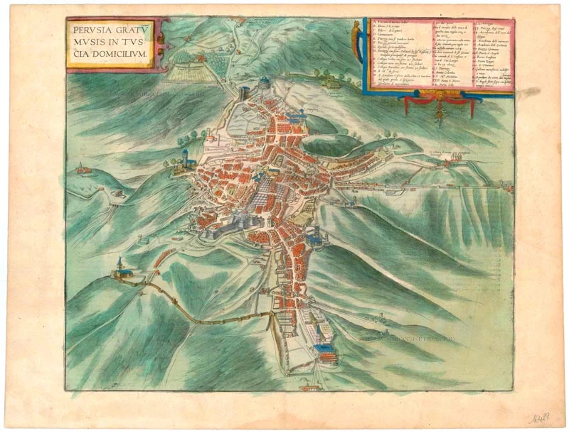
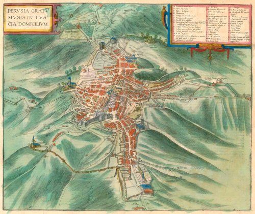
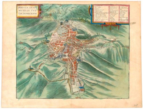

CARTOUCHE: Perugia, abode of the Muses in Tuscany.
COMMENTARY BY BRAUN: "Now let us take a closer look at the situation of the city of Perugia. It lies on a hill in the Apennines and is shaped like a star because most of the surrounding countryside is rolling, dotted with fertile and picturesque little hills, on which fine wine, olives, figs, apples and other excellent fruits are grown. Below the city, towards Assisi, and also in the direction of Todi near the Tiber, are charming and fertile plains and arable land on which wheat and other cereals are cultivated. The city is a natural and secure fortress. It is adorned with magnificent buildings, both patrician houses and churches, and, moreover, it boasts a celebrated fountain gushing with abundant water at the town centre."
Seen from the south in a bird's-eye view, the city sprawls across several hills and, in places, is protected by city walls and gates that make it look like a fortress. Some of its most important churches are on the periphery: on the northern edge of the city are Sant'Angelo at the centre and, near the southern boundary, San Pietro with a flat roof. Slightly above it in the picture is San Domenico. The complex comprising San Francesco and San Bernardino is on the city's western edge. At the centre is the cathedral of San Lorenzo, a Gothic hall church. In front of the cathedral tower stands the celebrated Fontana Maggiore. An early ingenious settlement, Perugia flourished in the Middle Ages. It belonged to the Papal States from 1520 to 1680. Today the city with its university founded in 1276 is the capital of the province of Umbria. (Taschen)
Braun G. & Hogenberg F. and the Civitates Orbis Terrarum.
The Civitates Orbis Terrarum, also known as the 'Braun & Hogenberg', is a six-volume town atlas and the most excellent book of town views and plans ever published: 363 engravings, sometimes beautifully coloured. It was one of the best-selling works in the last quarter of the 16th century. Georg Braun, a skilled writer, wrote the text accompanying the plans and views on the verso. Many plates were engraved after the original drawings of a professional artist, Joris Hoefnagel (1542-1600). The first volume was published in Latin in 1572 and the sixth in 1617. Frans Hogenberg, a talented engraver, created the tables for volumes I through IV, and Simon van den Neuwel made those for volumes V and VI. Other contributors were cartographers Daniel Freese and Heinrich Rantzau, who provided valuable geographical information. Works by Jacob van Deventer, Sebastian Münster, and Johannes Stumpf were also used as references. Translations appeared in German and French, making the atlas accessible to a broader audience.
Since its original publication of volume 1 in 1572, the Civitates Orbis Terrarum has left an indelible mark on the history of cartography. Seven more editions followed the first volume in 1575, 1577, 1582, 1588, 1593, 1599, and 1612. Vol.2, initially released in 1575, saw subsequent editions in 1597 and 1612. The subsequent volumes, each a treasure trove of historical insights, graced the world in 1581, 1588, 1593, 1599, and 1606. The German translation of the first volume, a testament to its widespread appeal, debuted in 1574, followed by the French edition in 1575.
Several printers were involved: Theodor Graminaeus, Heinrich von Aich, Gottfried von Kempen, Johannis Sinniger, Bertram Buchholtz, and Peter von Brachel, all of whom worked in Cologne.
Georg Braun (1541-1622)
Georg Braun, the author of the text accompanying the plans and views in the Civitates Orbis Terrarum, was born in Cologne in 1541. After his studies in Cologne, he entered the Jesuit Order as a novice, indicating his commitment to learning and intellectual pursuits. In 1561, he obtained his bachelor's degree; in 1562, he received his Magister Artium, further demonstrating his academic achievements. Although he left the Jesuit Order, he continued his studies in theology, gaining a licentiate in theology. His theological background likely influenced the content and tone of the text in the Civitates Orbis Terrarum, adding a unique perspective to the work.
Frans Hogenberg (1535-1590)
Frans Hogenberg was a Flemish and German painter, engraver, and mapmaker. He was born in Mechelen as the son of Nicolaas Hogenberg.
By the end of the 1560s, Frans Hogenberg was employed upon Abraham Ortelius's Theatrum Orbis Terrarum, published in 1570; he is named an engraver of numerous maps. In 1568, he was banned from Antwerp by the Duke of Alva and travelled to London, where he stayed a few years before emigrating to Cologne. He immediately embarked on his two most important works, the Civitates, published in 1572 and the Geschichtsblätter, which appeared in several series from 1569 until about 1587.
Thanks to large-scale projects like the Geschichtsblätter and the Civitates, Hogenberg's social circumstances improved with each passing year. He died as a wealthy man in Cologne in 1590.
Perusia Gratumusis in Tuscia Domicilium.
Item Number: 16429 Authenticity Guarantee
Category: Antique maps > Europe > Italy - Cities
Old, antique bird’s-eye view plan of Perugia, by Georg Braun and Frans Hogenberg.
Title: Perusia Gratumusis in Tuscia Domicilium.
Date of the first edition: 1588.
Date of this map: 1635.
Copper engraving, printed on paper.
Size (not including margins): 365 x 435mm (14.37 x 17.13 inches).
Verso: Latin text.
Condition: Excellent, superb old colour.
Condition Rating: A+.
From: Civitates Orbis Terrarum. Liber quartus Urbium Praecipuarum totius Mundi. Cologne, Petrus von Brachel, 1635. (Van der Krogt 4, 41:1.4)
CARTOUCHE: Perugia, abode of the Muses in Tuscany.
COMMENTARY BY BRAUN: "Now let us take a closer look at the situation of the city of Perugia. It lies on a hill in the Apennines and is shaped like a star because most of the surrounding countryside is rolling, dotted with fertile and picturesque little hills, on which fine wine, olives, figs, apples and other excellent fruits are grown. Below the city, towards Assisi, and also in the direction of Todi near the Tiber, are charming and fertile plains and arable land on which wheat and other cereals are cultivated. The city is a natural and secure fortress. It is adorned with magnificent buildings, both patrician houses and churches, and, moreover, it boasts a celebrated fountain gushing with abundant water at the town centre."
Seen from the south in a bird's-eye view, the city sprawls across several hills and, in places, is protected by city walls and gates that make it look like a fortress. Some of its most important churches are on the periphery: on the northern edge of the city are Sant'Angelo at the centre and, near the southern boundary, San Pietro with a flat roof. Slightly above it in the picture is San Domenico. The complex comprising San Francesco and San Bernardino is on the city's western edge. At the centre is the cathedral of San Lorenzo, a Gothic hall church. In front of the cathedral tower stands the celebrated Fontana Maggiore. An early ingenious settlement, Perugia flourished in the Middle Ages. It belonged to the Papal States from 1520 to 1680. Today the city with its university founded in 1276 is the capital of the province of Umbria. (Taschen)
Braun G. & Hogenberg F. and the Civitates Orbis Terrarum.
The Civitates Orbis Terrarum, also known as the 'Braun & Hogenberg', is a six-volume town atlas and the most excellent book of town views and plans ever published: 363 engravings, sometimes beautifully coloured. It was one of the best-selling works in the last quarter of the 16th century. Georg Braun, a skilled writer, wrote the text accompanying the plans and views on the verso. Many plates were engraved after the original drawings of a professional artist, Joris Hoefnagel (1542-1600). The first volume was published in Latin in 1572 and the sixth in 1617. Frans Hogenberg, a talented engraver, created the tables for volumes I through IV, and Simon van den Neuwel made those for volumes V and VI. Other contributors were cartographers Daniel Freese and Heinrich Rantzau, who provided valuable geographical information. Works by Jacob van Deventer, Sebastian Münster, and Johannes Stumpf were also used as references. Translations appeared in German and French, making the atlas accessible to a broader audience.
Since its original publication of volume 1 in 1572, the Civitates Orbis Terrarum has left an indelible mark on the history of cartography. Seven more editions followed the first volume in 1575, 1577, 1582, 1588, 1593, 1599, and 1612. Vol.2, initially released in 1575, saw subsequent editions in 1597 and 1612. The subsequent volumes, each a treasure trove of historical insights, graced the world in 1581, 1588, 1593, 1599, and 1606. The German translation of the first volume, a testament to its widespread appeal, debuted in 1574, followed by the French edition in 1575.
Several printers were involved: Theodor Graminaeus, Heinrich von Aich, Gottfried von Kempen, Johannis Sinniger, Bertram Buchholtz, and Peter von Brachel, all of whom worked in Cologne.
Georg Braun (1541-1622)
Georg Braun, the author of the text accompanying the plans and views in the Civitates Orbis Terrarum, was born in Cologne in 1541. After his studies in Cologne, he entered the Jesuit Order as a novice, indicating his commitment to learning and intellectual pursuits. In 1561, he obtained his bachelor's degree; in 1562, he received his Magister Artium, further demonstrating his academic achievements. Although he left the Jesuit Order, he continued his studies in theology, gaining a licentiate in theology. His theological background likely influenced the content and tone of the text in the Civitates Orbis Terrarum, adding a unique perspective to the work.
Frans Hogenberg (1535-1590)
Frans Hogenberg was a Flemish and German painter, engraver, and mapmaker. He was born in Mechelen as the son of Nicolaas Hogenberg.
By the end of the 1560s, Frans Hogenberg was employed upon Abraham Ortelius's Theatrum Orbis Terrarum, published in 1570; he is named an engraver of numerous maps. In 1568, he was banned from Antwerp by the Duke of Alva and travelled to London, where he stayed a few years before emigrating to Cologne. He immediately embarked on his two most important works, the Civitates, published in 1572 and the Geschichtsblätter, which appeared in several series from 1569 until about 1587.
Thanks to large-scale projects like the Geschichtsblätter and the Civitates, Hogenberg's social circumstances improved with each passing year. He died as a wealthy man in Cologne in 1590.
Related items

Perusia. 1657
Perugia, by J. Janssonius.
[Item number: 31820]

Tractus Perusinus. 1618
Perugia by Petrus Bertius, published by Jodocus Hondius II.
[Item number: 31870]

Territorio Perugino. 1645
Perugia, by Willem & Joan Blaeu.
[Item number: 33101]
new