
Catania with view of the Mount Etna by Georg Braun & Frans Hogenberg, published by J. Janssonius. 1657


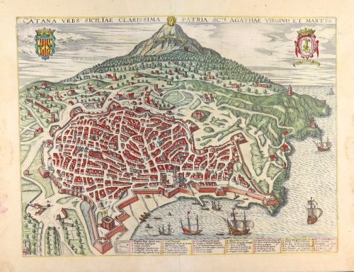
TRANSLATION OF CAPTION: Catania is a very famous town in Sicily, the birthplace of St Agatha, virgin and martyr.
COMMENTARY BY BRAUN (on verso): "Catania is a very old town in Sicily, which was praised by the Greek and Roman authors. It borders on the sea on one side and Etna on the other [...]. On the side from which one sails for Naxos, the town formerly had a magnificent maritime harbour; this was filled in by Etna's enormous eruption, however, so that nothing but a mound of large rocks lies on this spot today. The town was formerly also very well known for its mounted troops. Today the city is famous for the Liberal Arts that are taught there. One also finds that people learned a lot about imperial and papal law here."
The engraving offers a bird's-eye view from the south of the formerly well-fortified town of Catania, with Mount Etna rising directly behind it. On the Piazza del Duomo (26), the cathedral of Sant'Agata lies opposite the town hall (3). Preserved within the town are several antique monuments, including the amphitheatre (15) incorporated into the city wall: originally able to hold up to 15,000 spectators, it was almost as large as the Coliseum in Rome. To the left lies the church of Sant'Agata al Carcere (6), built in honour of the town's patron saint on the site where she was imprisoned before her death. The founding of Catania dates back to the 8th century AD when it was settled by Greeks on the Island of Naxos. The town was entirely destroyed in 1669 following a massive eruption by Etna and in 1693 by a catastrophic earthquake. Black lava stone was used to rebuild the town, so it is often described as Etna's "black daughter". (Taschen)
Braun G. & Hogenberg F. and the Civitates Orbis Terrarum.
The Civitates Orbis Terrarum, also known as the 'Braun & Hogenberg', is a six-volume town atlas and the most excellent book of town views and plans ever published: 363 engravings, sometimes beautifully coloured. It was one of the best-selling works in the last quarter of the 16th century. Georg Braun, a skilled writer, wrote the text accompanying the plans and views on the verso. Many plates were engraved after the original drawings of a professional artist, Joris Hoefnagel (1542-1600). The first volume was published in Latin in 1572 and the sixth in 1617. Frans Hogenberg, a talented engraver, created the tables for volumes I through IV, and Simon van den Neuwel made those for volumes V and VI. Other contributors were cartographers Daniel Freese and Heinrich Rantzau, who provided valuable geographical information. Works by Jacob van Deventer, Sebastian Münster, and Johannes Stumpf were also used as references. Translations appeared in German and French, making the atlas accessible to a broader audience.
Since its original publication of volume 1 in 1572, the Civitates Orbis Terrarum has left an indelible mark on the history of cartography. Seven more editions followed the first volume in 1575, 1577, 1582, 1588, 1593, 1599, and 1612. Vol.2, initially released in 1575, saw subsequent editions in 1597 and 1612. The subsequent volumes, each a treasure trove of historical insights, graced the world in 1581, 1588, 1593, 1599, and 1606. The German translation of the first volume, a testament to its widespread appeal, debuted in 1574, followed by the French edition in 1575.
Several printers were involved: Theodor Graminaeus, Heinrich von Aich, Gottfried von Kempen, Johannis Sinniger, Bertram Buchholtz, and Peter von Brachel, all of whom worked in Cologne.
Georg Braun (1541-1622)
Georg Braun, the author of the text accompanying the plans and views in the Civitates Orbis Terrarum, was born in Cologne in 1541. After his studies in Cologne, he entered the Jesuit Order as a novice, indicating his commitment to learning and intellectual pursuits. In 1561, he obtained his bachelor's degree; in 1562, he received his Magister Artium, further demonstrating his academic achievements. Although he left the Jesuit Order, he continued his studies in theology, gaining a licentiate in theology. His theological background likely influenced the content and tone of the text in the Civitates Orbis Terrarum, adding a unique perspective to the work.
Frans Hogenberg (1535-1590)
Frans Hogenberg was a Flemish and German painter, engraver, and mapmaker. He was born in Mechelen as the son of Nicolaas Hogenberg.
By the end of the 1560s, Frans Hogenberg was employed upon Abraham Ortelius's Theatrum Orbis Terrarum, published in 1570; he is named an engraver of numerous maps. In 1568, he was banned from Antwerp by the Duke of Alva and travelled to London, where he stayed a few years before emigrating to Cologne. He immediately embarked on his two most important works, the Civitates, published in 1572 and the Geschichtsblätter, which appeared in several series from 1569 until about 1587.
Thanks to large-scale projects like the Geschichtsblätter and the Civitates, Hogenberg's social circumstances improved with each passing year. He died as a wealthy man in Cologne in 1590.
The Janssonius Family
Joannes Janssonius (Arnhem, 1588-1664), son of the Arnhem publisher Jan Janssen, married Elisabeth Hondius, daughter of Jodocus Hondius, in Amsterdam in 1612. After his marriage, he settled down in this town as a bookseller and publisher of cartographic material. In 1618, he established himself in Amsterdam next door to Blaeu’s bookshop. He entered into serious competition with Willem Jansz. Blaeu when copying Blaeu’s Licht der Zeevaert after the expiration of the privilege in 1620. His activities concerned the publication of atlases, books, single maps, and an extensive book trade with branches in Frankfurt, Danzig, Stockholm, Copenhagen, Berlin, Koningsbergen, Geneva, and Lyon. In 1631, he began publishing atlases together with Henricus Hondius.
In the early 1640s, Henricus Hondius left the atlas publishing business to Janssonius. Competition with Joan Blaeu, Willem’s son and successor, in atlas production, prompted Janssonius to enlarge his Atlas Novus finally into a work of six volumes, into which a sea atlas and an atlas of the Old World were inserted. Other atlases published by Janssonius are Mercator’s Atlas Minor, Hornius’s historical atlas (1652), the townbooks in eight volumes (1657), Cellarius’s Atlas Coelestis and several sea atlases and pilot guides.
After the death of Joannes Janssonius, the shop and publishing firm were continued by the heirs under the direction of Johannes van Waesbergen (c. 1616-1681), son-in-law of Joannes Janssonius. Van Waesbergen added Janssonius's name to his own.
In 1676, Joannes Janssonius’s heirs sold by auction “all the remaining Atlases in Latin, French, High and Low German, as well as the Stedeboecken in Latin, in 8 volumes, bound and unbound, maps, plates belonging to the Atlas and Stedeboecken.” The copperplates from Janssonius’s atlases were afterwards sold to Schenk and Valck.
Catana Urbs Siciliae Clarissima Patriae Scte Agathae Virginis et Mart:
Item Number: 31003 Authenticity Guarantee
Category: Antique maps > Europe > Italy - Cities
Sicily - Catana with view of the Mount Etna by Georg Braun & Frans Hogenberg, published by J. Janssonius.
Title: Catana Urbs Siciliae Clarissima Patriae Scte Agathae Virginis et Mart:
Date of the first edition: 1596.
Date of this map: 1657.
State 2: Ships in the sea replaced by ùmote modern types.
Copper engraving, printed on paper.
Image size: 370 x 495mm (14.57 x 19.49 inches).
Sheet size: 450 x 565mm (17.72 x 22.24 inches).
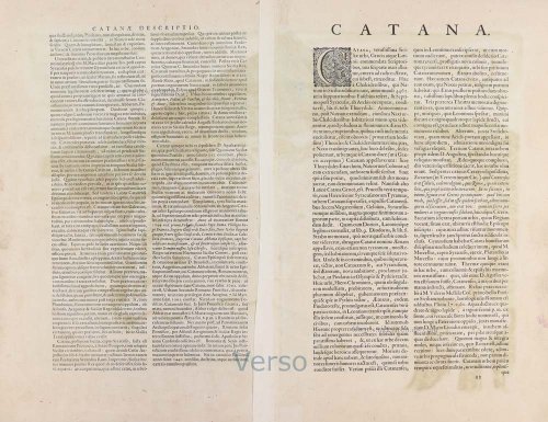
Verso: Latin text.
Condition: Original coloured, excellent.
Condition Rating: A+.
From: Theatrum Celebriorum Urbium Italiae, aliarumque in Insulis Maris Mediterranei. Amsterdam, J. Janssonius [1657]. (Van der Krogt 4, p. 282, 42:15)
TRANSLATION OF CAPTION: Catania is a very famous town in Sicily, the birthplace of St Agatha, virgin and martyr.
COMMENTARY BY BRAUN (on verso): "Catania is a very old town in Sicily, which was praised by the Greek and Roman authors. It borders on the sea on one side and Etna on the other [...]. On the side from which one sails for Naxos, the town formerly had a magnificent maritime harbour; this was filled in by Etna's enormous eruption, however, so that nothing but a mound of large rocks lies on this spot today. The town was formerly also very well known for its mounted troops. Today the city is famous for the Liberal Arts that are taught there. One also finds that people learned a lot about imperial and papal law here."
The engraving offers a bird's-eye view from the south of the formerly well-fortified town of Catania, with Mount Etna rising directly behind it. On the Piazza del Duomo (26), the cathedral of Sant'Agata lies opposite the town hall (3). Preserved within the town are several antique monuments, including the amphitheatre (15) incorporated into the city wall: originally able to hold up to 15,000 spectators, it was almost as large as the Coliseum in Rome. To the left lies the church of Sant'Agata al Carcere (6), built in honour of the town's patron saint on the site where she was imprisoned before her death. The founding of Catania dates back to the 8th century AD when it was settled by Greeks on the Island of Naxos. The town was entirely destroyed in 1669 following a massive eruption by Etna and in 1693 by a catastrophic earthquake. Black lava stone was used to rebuild the town, so it is often described as Etna's "black daughter". (Taschen)
Braun G. & Hogenberg F. and the Civitates Orbis Terrarum.
The Civitates Orbis Terrarum, also known as the 'Braun & Hogenberg', is a six-volume town atlas and the most excellent book of town views and plans ever published: 363 engravings, sometimes beautifully coloured. It was one of the best-selling works in the last quarter of the 16th century. Georg Braun, a skilled writer, wrote the text accompanying the plans and views on the verso. Many plates were engraved after the original drawings of a professional artist, Joris Hoefnagel (1542-1600). The first volume was published in Latin in 1572 and the sixth in 1617. Frans Hogenberg, a talented engraver, created the tables for volumes I through IV, and Simon van den Neuwel made those for volumes V and VI. Other contributors were cartographers Daniel Freese and Heinrich Rantzau, who provided valuable geographical information. Works by Jacob van Deventer, Sebastian Münster, and Johannes Stumpf were also used as references. Translations appeared in German and French, making the atlas accessible to a broader audience.
Since its original publication of volume 1 in 1572, the Civitates Orbis Terrarum has left an indelible mark on the history of cartography. Seven more editions followed the first volume in 1575, 1577, 1582, 1588, 1593, 1599, and 1612. Vol.2, initially released in 1575, saw subsequent editions in 1597 and 1612. The subsequent volumes, each a treasure trove of historical insights, graced the world in 1581, 1588, 1593, 1599, and 1606. The German translation of the first volume, a testament to its widespread appeal, debuted in 1574, followed by the French edition in 1575.
Several printers were involved: Theodor Graminaeus, Heinrich von Aich, Gottfried von Kempen, Johannis Sinniger, Bertram Buchholtz, and Peter von Brachel, all of whom worked in Cologne.
Georg Braun (1541-1622)
Georg Braun, the author of the text accompanying the plans and views in the Civitates Orbis Terrarum, was born in Cologne in 1541. After his studies in Cologne, he entered the Jesuit Order as a novice, indicating his commitment to learning and intellectual pursuits. In 1561, he obtained his bachelor's degree; in 1562, he received his Magister Artium, further demonstrating his academic achievements. Although he left the Jesuit Order, he continued his studies in theology, gaining a licentiate in theology. His theological background likely influenced the content and tone of the text in the Civitates Orbis Terrarum, adding a unique perspective to the work.
Frans Hogenberg (1535-1590)
Frans Hogenberg was a Flemish and German painter, engraver, and mapmaker. He was born in Mechelen as the son of Nicolaas Hogenberg.
By the end of the 1560s, Frans Hogenberg was employed upon Abraham Ortelius's Theatrum Orbis Terrarum, published in 1570; he is named an engraver of numerous maps. In 1568, he was banned from Antwerp by the Duke of Alva and travelled to London, where he stayed a few years before emigrating to Cologne. He immediately embarked on his two most important works, the Civitates, published in 1572 and the Geschichtsblätter, which appeared in several series from 1569 until about 1587.
Thanks to large-scale projects like the Geschichtsblätter and the Civitates, Hogenberg's social circumstances improved with each passing year. He died as a wealthy man in Cologne in 1590.
The Janssonius Family
Joannes Janssonius (Arnhem, 1588-1664), son of the Arnhem publisher Jan Janssen, married Elisabeth Hondius, daughter of Jodocus Hondius, in Amsterdam in 1612. After his marriage, he settled down in this town as a bookseller and publisher of cartographic material. In 1618, he established himself in Amsterdam next door to Blaeu’s bookshop. He entered into serious competition with Willem Jansz. Blaeu when copying Blaeu’s Licht der Zeevaert after the expiration of the privilege in 1620. His activities concerned the publication of atlases, books, single maps, and an extensive book trade with branches in Frankfurt, Danzig, Stockholm, Copenhagen, Berlin, Koningsbergen, Geneva, and Lyon. In 1631, he began publishing atlases together with Henricus Hondius.
In the early 1640s, Henricus Hondius left the atlas publishing business to Janssonius. Competition with Joan Blaeu, Willem’s son and successor, in atlas production, prompted Janssonius to enlarge his Atlas Novus finally into a work of six volumes, into which a sea atlas and an atlas of the Old World were inserted. Other atlases published by Janssonius are Mercator’s Atlas Minor, Hornius’s historical atlas (1652), the townbooks in eight volumes (1657), Cellarius’s Atlas Coelestis and several sea atlases and pilot guides.
After the death of Joannes Janssonius, the shop and publishing firm were continued by the heirs under the direction of Johannes van Waesbergen (c. 1616-1681), son-in-law of Joannes Janssonius. Van Waesbergen added Janssonius's name to his own.
In 1676, Joannes Janssonius’s heirs sold by auction “all the remaining Atlases in Latin, French, High and Low German, as well as the Stedeboecken in Latin, in 8 volumes, bound and unbound, maps, plates belonging to the Atlas and Stedeboecken.” The copperplates from Janssonius’s atlases were afterwards sold to Schenk and Valck.
Related items

Insularum Aliquot Maris Mediterranei Descriptio. 1592
Sicily, Sardinia, Corfu, Zerbi, Elba, Malta by Abraham Ortelius.
[Item number: 23053]

Sicilia. 1618
Sicily (Sicilia) by Petrus Bertius, published by Jodocus Hondius II.
[Item number: 31860]
Regnorum Siciliae et Sardiniae nec non Melitae seu Maltae insuli cum adjectis Italiae et Africae Litoribus Nova Tabula. c. 1720
Sicily - Sardinia, by J.B. Homann.
[Item number: 32164]

Tabula Moderna Italie. 1525
Corsica, Sardinia, and Sicilia (Sicily), by Lorenz Fries.
[Item number: 32732]
Isola e Regno di Sicilia 1684
Sicilia, by Giacomo Cantelli da Vignola, published by Giovanni de Rossi.
[Item number: 32915]

Parergon map
Siciliae Veteris Typus. 1592
Ancient Sicily, by Abraham Ortelius.
[Item number: 33064]
new

Insula sive Regnum Siciliae Urbibus praecipuis exornatum 1682-88
Sicily by Frederick de Wit.
[Item number: 33168]
new