
Campagna di Roma (Latium) by Gerard Mercator, published by Jodocus Hondius. 1607


Gerard Mercator (1512 – 1594)
Gerard Mercator was born Gerard de Cremere in Rupelmonde (near Antwerp) on 5 March 1512.
Young Gerard learned what Latin he could in Rupelmonde, and when he was about fifteen, his uncle sent him to s'Hertogenbosch to study at a school run by the Brothers of the Common Life. One of Mercator’s teachers was the celebrated humanist Macropedius. After three and a half years with the brothers, Gerard went to Louvain, where he enrolled in the university in 1530 as one of the poor students at Castle College.
By this time, he had Latinized his name to Mercator. He studied philosophy and took his master’s degree in 1532. The problems of the creation of the Universe and the Earth interested him in particular, and this is reflected in his works written in later years.
After spending a few years in Antwerp, he returned to Louvain in c. 1535, where he took courses in mathematics under Gemma Frisius. Soon, he was recognised as an expert on the construction of mathematical instruments, as a land surveyor and, after 1537, as a cartographer. He drew his income from these activities after his marriage on August 3, 1536. He also qualified himself as a copper engraver, the first to introduce italic handwriting to this trade. The first maps, drawn and engraved by Gerard Mercator, are Palestine, 1537; the World in double heart-shaped projection, 1538; and Flanders, 1540.
In 1544, Mercator came into great danger: he was arrested on the accusation of heresy and put into jail. Thanks to the intervention of the University of Louvain, he was released after four months. In 1552, he moved with his family to Duisburg (Germany). In 1560, Mercator became a cosmographer in service of the Duke of Jülich-Cleve-Berge, and in 1563, he became a lecturer at the Grammar School of the new University in Duisburg. During this period, he made wall maps of Europe, 1554; of Loraine, 1564; the British Isles, 1564; and the famous world map with increasing latitudes, 1569. About this time, Mercator was also working on the project for a complete description of the creation, the Heavens, Earth, Sea and world history. This resulted in his Atlas, sive cosmographicae meditationes de fabrica mundi et fabricati figura. He also worked on an edition of Ptolemy’s Geographia in 1578. The first part of his book, which contains modern maps (France, Germany, and the Netherlands), appeared in 1585.
Shortly after the publication of the second part of his map book (not yet called Atlas) with the maps of Italy (1589), he had a stroke that ended his highly significant productivity. The great man passed away on 2 December 1594, leaving the responsibility of finishing the map book to his son Rumold. The final part of it appeared in 1595. Its title is Pars Altera, and it constitutes an essential part of what was then called Mercator’s Atlas.
The map of Europe and the world map in the Atlas are by Rumold Mercator. After Rumold died in 1599, the Atlas was reissued in 1602.
The plates of the maps, both of the Ptolemy edition and the Atlas, were sold in 1604 to Jodocus Hondius of Amsterdam. The following year, Hondius managed to bring out Ptolemy’s Geographia. In 1606, the first Amsterdam edition of the Mercator Atlas appeared in the next year. From then to 1638, the Atlas saw many enlarged editions in various languages.
The Hondius Family
Jodocus Hondius the Elder (1563-1612)
Joost d’Hondt was born at Wakken (Flanders) in 1563. Two years later, his family settled in Ghent, where young Joost displayed an excellent gift for drawing and calligraphy. Through study and lessons, he developed his talents and became an engraver with a good reputation.
Due to the circumstances of the war, he moved to London in 1584, where he settled down as an engraver, instrument-maker, and map-maker. In 1587, he married Coletta van den Keere, sister of the well-known engraver Pieter van den Keere (Petrus Kaerius); some years earlier, his sister, Jacomina, had married Pieter van den Berghe (Petrus Montanus). Joost, who had Latinized his name to Jodocus Hondius, closely co-operated with his two brothers-in-law.
The political situation in the Northern Netherlands in 1593 was such that Jodocus seemed justified in establishing himself in Amsterdam, where many Antwerp printers, publishers, and engravers had gone. In this new centre of cartography, Jodocus Hondius set up his business “In de Wackere Hondt” (in the vigilant dog), this name being an allusion to his birthplace and name. He engraved many maps and published atlases and many other works, such as his continuation of Gerard Mercator’s Atlas.
He suddenly passed away in February 1612. The publishing firm of Jodocus Hondius was continued by his widow, later on, by his two sons, Jodocus Jr. and Henricus, and by his son-in-law, J. Janssonius.
Jodocus Hondius II (1594-1629) & Henricus Hondius (1597-1651)
After the father’s death, the widow and her seven children continued publishing the atlases under the name of Jodocus Hondius till 1620. The firm was reinforced by the very welcome help of Joannes Janssonius (1588-1664), who married 24-year-old Elisabeth Hondius in 1612. After 1619, Mercator’s Atlas was published under the name of Henricus Hondius.
One of the most dramatic events in the early history of commercial cartography in Amsterdam was the sale of Jodocus Hondius Jr.’s copper plates to Willem Jansz. Blaeu in 1629, the year of his death. At least 34 plates, from which Jodocus II had printed single-sheet maps for his benefit, passed into the hands of his great competitor. Immediately after that, his brother, Henricus, and Joannes Janssonius ordered the engraving of identical plates.
Henricus devoted all his energy to publishing the Atlas for an extended period. He saw its growth up to and including the fourth part in 1646; after that, his name no longer figures on the title pages. After 1638, the title of the Atlas was changed to Atlas Novus; Joannes Janssonius mainly carried it on.
The competition with the Blaeu's dates from 1630. In 1630, Willem Janszoon (=Blaeu) first attacked with his Atlantis Appendix. In 1635, Blaeu completed his Theatrum Orbis Terrarum in two volumes with French, Latin, Dutch, and German texts, prompting Henricus Hondius to speed up the enlargement of his Atlas.
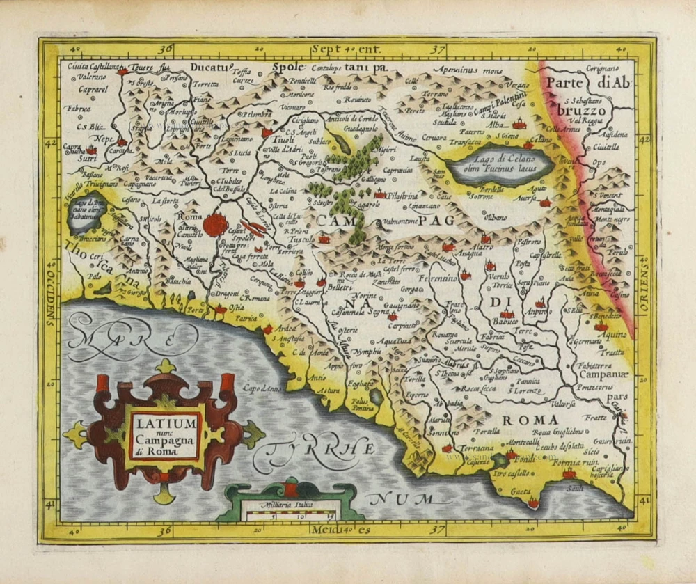
Latium nunc Campagna di Roma.
Item Number: 31460 Authenticity Guarantee
Category: Antique maps > Europe > Italy
Campagna di Roma (Latium), by Gerard Mercator, published by Jodocus Hondius.
Title: Latium nunc Campagna di Roma.
Date of the first edition: 1607.
Date of this map: 1607.
Copper engraving, printed on paper.
Image size: 150 x 180mm (6 x 7 inches).
Sheet size: 170 x 220mm (6¾ x 8¾ inches).
Verso: Latin text.
Condition: Original coloured, excellent.
Condition Rating: A+.
From: Atlas Minor. Amsterdam, Jodocus Hondius, [1607]. (Van der Krogt IIIB, p. 466, 351:01)
Gerard Mercator (1512 – 1594)
Gerard Mercator was born Gerard de Cremere in Rupelmonde (near Antwerp) on 5 March 1512.
Young Gerard learned what Latin he could in Rupelmonde, and when he was about fifteen, his uncle sent him to s'Hertogenbosch to study at a school run by the Brothers of the Common Life. One of Mercator’s teachers was the celebrated humanist Macropedius. After three and a half years with the brothers, Gerard went to Louvain, where he enrolled in the university in 1530 as one of the poor students at Castle College.
By this time, he had Latinized his name to Mercator. He studied philosophy and took his master’s degree in 1532. The problems of the creation of the Universe and the Earth interested him in particular, and this is reflected in his works written in later years.
After spending a few years in Antwerp, he returned to Louvain in c. 1535, where he took courses in mathematics under Gemma Frisius. Soon, he was recognised as an expert on the construction of mathematical instruments, as a land surveyor and, after 1537, as a cartographer. He drew his income from these activities after his marriage on August 3, 1536. He also qualified himself as a copper engraver, the first to introduce italic handwriting to this trade. The first maps, drawn and engraved by Gerard Mercator, are Palestine, 1537; the World in double heart-shaped projection, 1538; and Flanders, 1540.
In 1544, Mercator came into great danger: he was arrested on the accusation of heresy and put into jail. Thanks to the intervention of the University of Louvain, he was released after four months. In 1552, he moved with his family to Duisburg (Germany). In 1560, Mercator became a cosmographer in service of the Duke of Jülich-Cleve-Berge, and in 1563, he became a lecturer at the Grammar School of the new University in Duisburg. During this period, he made wall maps of Europe, 1554; of Loraine, 1564; the British Isles, 1564; and the famous world map with increasing latitudes, 1569. About this time, Mercator was also working on the project for a complete description of the creation, the Heavens, Earth, Sea and world history. This resulted in his Atlas, sive cosmographicae meditationes de fabrica mundi et fabricati figura. He also worked on an edition of Ptolemy’s Geographia in 1578. The first part of his book, which contains modern maps (France, Germany, and the Netherlands), appeared in 1585.
Shortly after the publication of the second part of his map book (not yet called Atlas) with the maps of Italy (1589), he had a stroke that ended his highly significant productivity. The great man passed away on 2 December 1594, leaving the responsibility of finishing the map book to his son Rumold. The final part of it appeared in 1595. Its title is Pars Altera, and it constitutes an essential part of what was then called Mercator’s Atlas.
The map of Europe and the world map in the Atlas are by Rumold Mercator. After Rumold died in 1599, the Atlas was reissued in 1602.
The plates of the maps, both of the Ptolemy edition and the Atlas, were sold in 1604 to Jodocus Hondius of Amsterdam. The following year, Hondius managed to bring out Ptolemy’s Geographia. In 1606, the first Amsterdam edition of the Mercator Atlas appeared in the next year. From then to 1638, the Atlas saw many enlarged editions in various languages.
The Hondius Family
Jodocus Hondius the Elder (1563-1612)
Joost d’Hondt was born at Wakken (Flanders) in 1563. Two years later, his family settled in Ghent, where young Joost displayed an excellent gift for drawing and calligraphy. Through study and lessons, he developed his talents and became an engraver with a good reputation.
Due to the circumstances of the war, he moved to London in 1584, where he settled down as an engraver, instrument-maker, and map-maker. In 1587, he married Coletta van den Keere, sister of the well-known engraver Pieter van den Keere (Petrus Kaerius); some years earlier, his sister, Jacomina, had married Pieter van den Berghe (Petrus Montanus). Joost, who had Latinized his name to Jodocus Hondius, closely co-operated with his two brothers-in-law.
The political situation in the Northern Netherlands in 1593 was such that Jodocus seemed justified in establishing himself in Amsterdam, where many Antwerp printers, publishers, and engravers had gone. In this new centre of cartography, Jodocus Hondius set up his business “In de Wackere Hondt” (in the vigilant dog), this name being an allusion to his birthplace and name. He engraved many maps and published atlases and many other works, such as his continuation of Gerard Mercator’s Atlas.
He suddenly passed away in February 1612. The publishing firm of Jodocus Hondius was continued by his widow, later on, by his two sons, Jodocus Jr. and Henricus, and by his son-in-law, J. Janssonius.
Jodocus Hondius II (1594-1629) & Henricus Hondius (1597-1651)
After the father’s death, the widow and her seven children continued publishing the atlases under the name of Jodocus Hondius till 1620. The firm was reinforced by the very welcome help of Joannes Janssonius (1588-1664), who married 24-year-old Elisabeth Hondius in 1612. After 1619, Mercator’s Atlas was published under the name of Henricus Hondius.
One of the most dramatic events in the early history of commercial cartography in Amsterdam was the sale of Jodocus Hondius Jr.’s copper plates to Willem Jansz. Blaeu in 1629, the year of his death. At least 34 plates, from which Jodocus II had printed single-sheet maps for his benefit, passed into the hands of his great competitor. Immediately after that, his brother, Henricus, and Joannes Janssonius ordered the engraving of identical plates.
Henricus devoted all his energy to publishing the Atlas for an extended period. He saw its growth up to and including the fourth part in 1646; after that, his name no longer figures on the title pages. After 1638, the title of the Atlas was changed to Atlas Novus; Joannes Janssonius mainly carried it on.
The competition with the Blaeu's dates from 1630. In 1630, Willem Janszoon (=Blaeu) first attacked with his Atlantis Appendix. In 1635, Blaeu completed his Theatrum Orbis Terrarum in two volumes with French, Latin, Dutch, and German texts, prompting Henricus Hondius to speed up the enlargement of his Atlas.
Related items

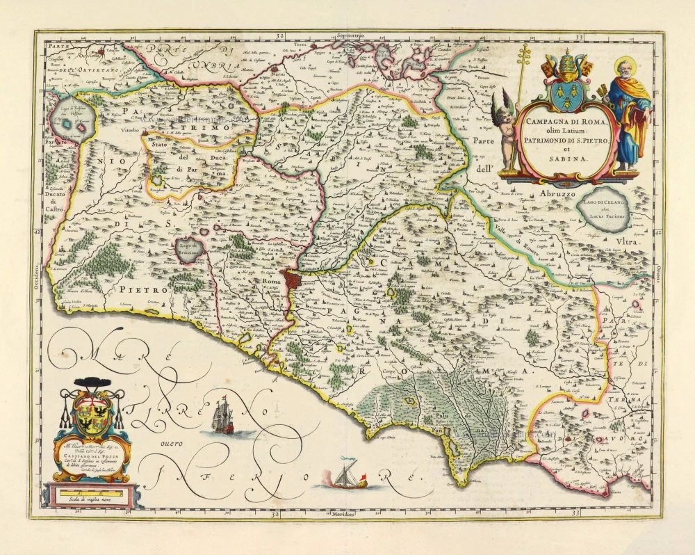
Campagna di Roma olim Latium Patrimonio de S. Pietro et Sabina. 1644-58
Campagna di Roma (Latium), by Johannes Janssonius - Henricus Hondius
[Item number: 22820]
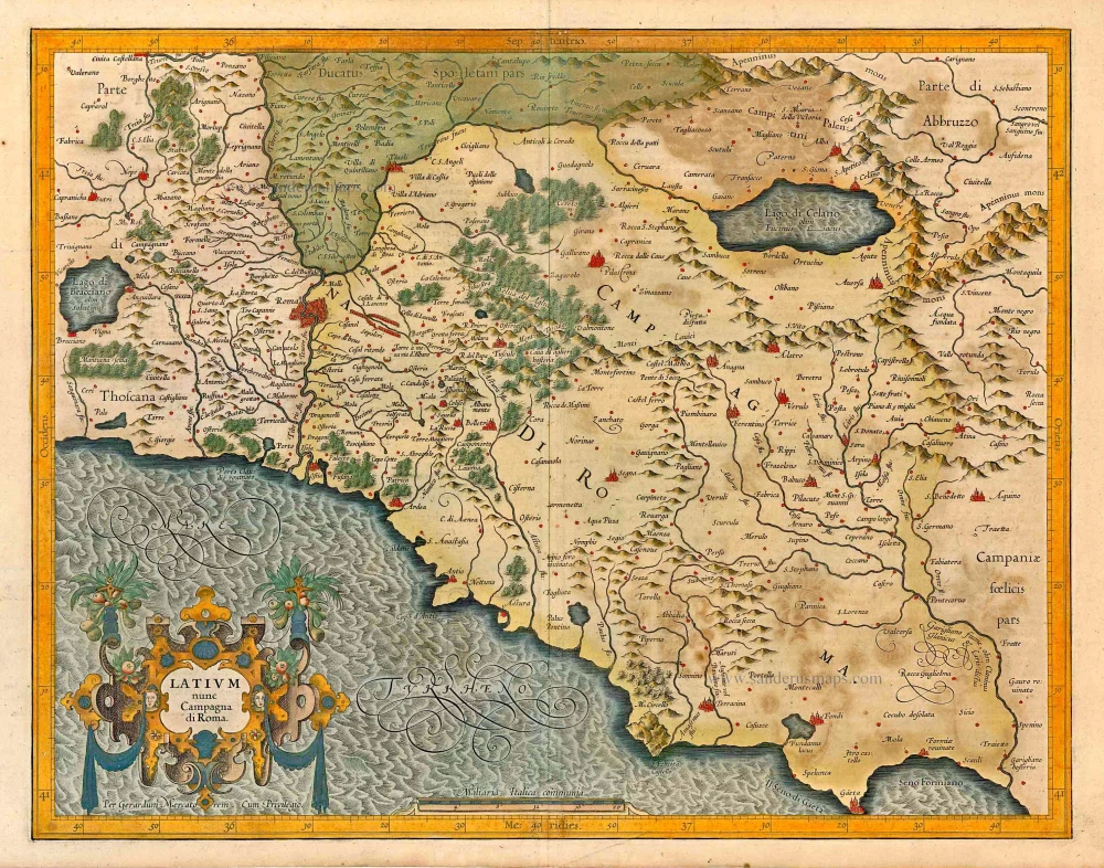
Latium nunc Campagna di Roma. 1623
Campagna di Roma (Latium), by Gerard Mercator.
[Item number: 27870]
Campagna di Roma olim Latium: Patrimonio di S. Pietro; et Sabina. 1650
Campagna di Roma (Latium), by Joan Blaeu.
[Item number: 28027]

Latium sive Campania di Roma. 1618
Campagna di Roma (Latium) by Petrus Bertius, published by Jodocus Hondius II.
[Item number: 31867]
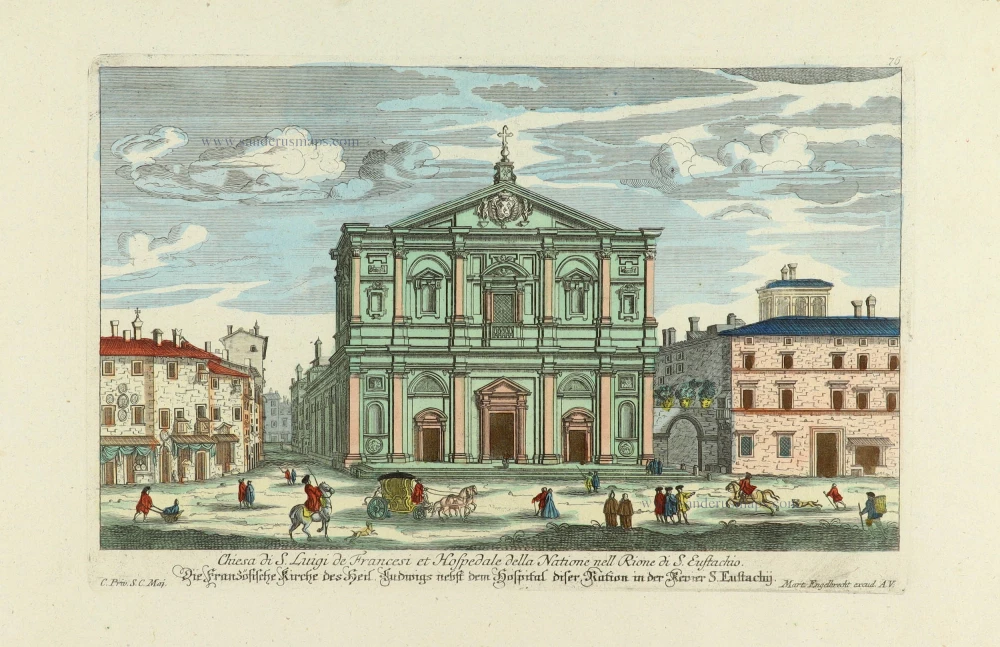
Chiesa di S. Luigi de Francesi et Hospedale della Natione nell Rione di S. Eustachio.- Die französische Kirche des heil. Ludwigs nebst dem Hospital diser Nation in der Revier S. Eustachij. c. 1750
Church of S. Luigi dei Francesi in Rome, by Martin Engelbrecht.
[Item number: 31924]
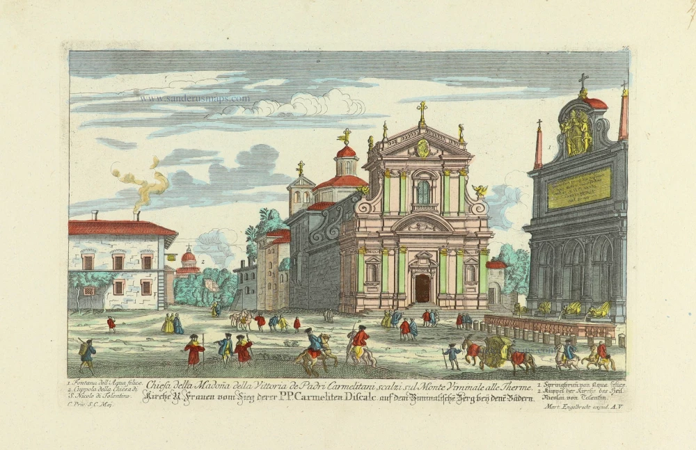
Chiesa di S. Luigi de Francesi et Hospedale della Natione nell Rione di S. Eustachio.- Kirche Frauen vom Sieg derer PP. Carmeliten Discale aud dem Viminalische Berg beij dene Bädern. c. 1750
Church of S. Luigi dei Francesi in Rome, by Martin Engelbrecht.
[Item number: 31925]
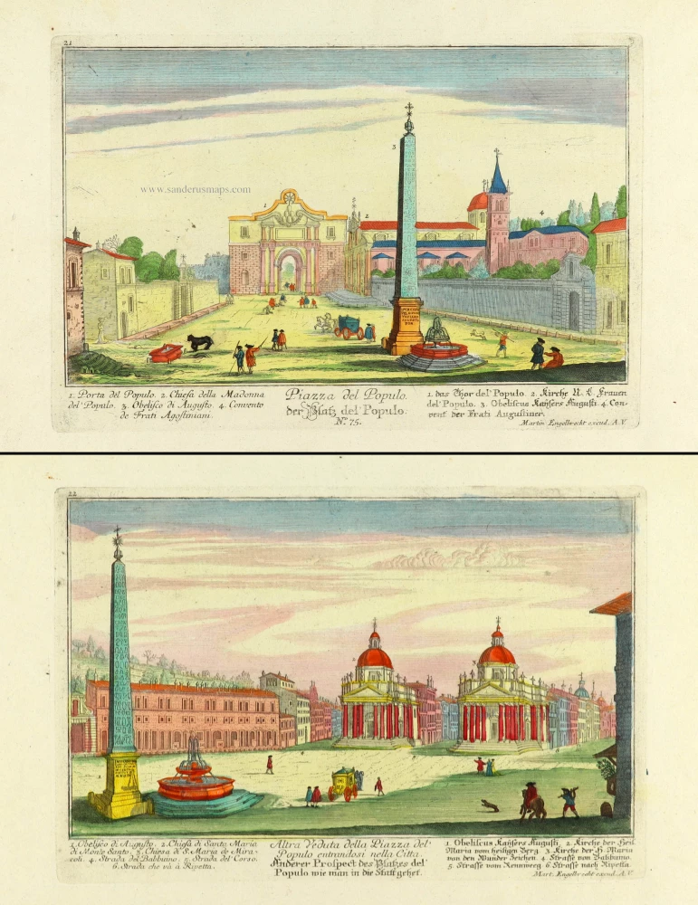
Piazza del Populo. - der Platz del Populo. [in set with] Altra Veduta della Piazza del Populo entrandosi nella Citta. - Anderer Prospect des Platzes del Populmo wie man in die Statt gehet. c. 1750
Two views of the Piazza del Populo in Rome (Roma), by Martin Engelbrecht.
[Item number: 31980]
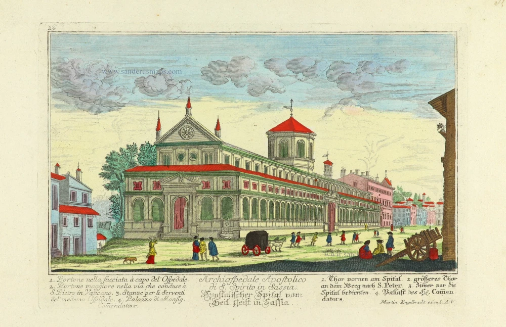
Archiospedale Apostolico fi S. Spirito in Sassia. - Apostolischer Spital vom Heil. Geist in Sassia. c. 1750
Church of S. Luigi dei Francesi in Rome, by Martin Engelbrecht.
[Item number: 31981]

Chiesa di S. Maria in Portico in Campinelli. - Kirche des H. Maria in Portico in Campinelli. c. 1750
Church of Santa Maria in Campitelli in Rome, by Martin Engelbrecht.
[Item number: 31982]

A view of Marcelluss Theatre at Rome. - Vue du fameux Theatre de Marcellus à Rome. c. 1750
Theatre of Marcellus in Rome, by Martin Engelbrecht.
[Item number: 31985]

Chiesa di Santa Bibiana sul Monte Esquilino. - Kirche des Heil. Bibiana auf dem Berge Esquilino. c. 1750
Church of the Saint Bibiana in Rome (Roma), by Martin Engelbrecht.
[Item number: 31995]
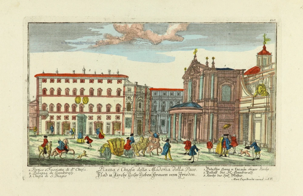
Piazza e Chiesa della Madoña delle Pace. - Platz u. Kirche Unser Lieben Frauen vom Frieden. c. 1750
Church of the S. Maria della Pace in Rome (Roma), by Martin Engelbrecht.
[Item number: 31996]

Chiesa di Santa Maria Transpontina de PP. Carmelitani, nella Regione di Borgo. - Kirche der H. Maria Traspontina der PP. Carmeliter in der Gegend di Borgo. c. 1750
Church of the S. Maria in Traspontina in Rome (Roma), by Martin Engelbrecht.
[Item number: 31997]
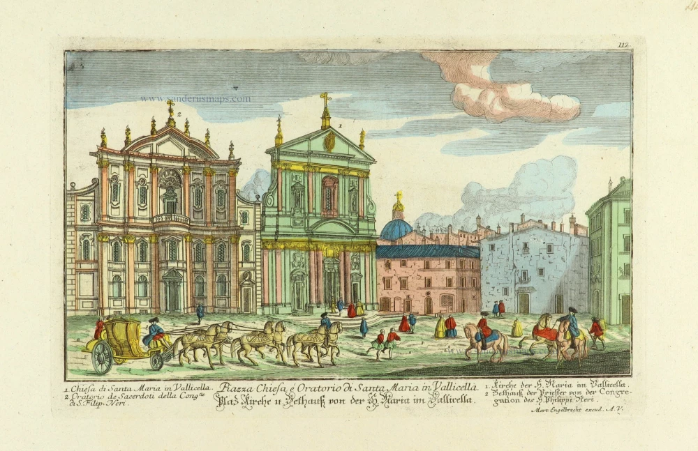
Piazza Chiesa é Oratorio di Santa Maria in Vallicella. - Platz Kirche u. Bethauß von der H. Maria im Vallicella. c. 1750
Church of the S. Maria in Vallicella in Rome (Roma), by Martin Engelbrecht.
[Item number: 31998]

Veduta della Chiesa e Spiagia di S. Nicolo di Castello à Venetia. - Prospect der Kirchen von St. Nicolaus vom Schloß und derselben angenehmen Gegens in Venedig. c. 1750
Church of S. Nicolo di Castello in Venice (Venezia), by Martin Engelbrecht.
[Item number: 31999]

Prospetto della Piazza di Castello Candolpho. - Prospect des Platzes vom Castell Candolpho. c. 1750
Rome (Roma) - Castel Candolfo (Papal residence), by Martin Engelbrecht.
[Item number: 32013]
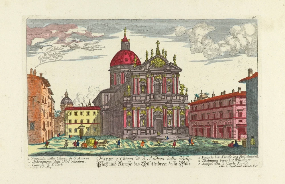
Piazza e Chiesa di S. Andrea della Valle. - Platz und Kirche des Heil. Andrea della Valle. c. 1750
Rome (Roma) - Church of S. Andrea della Valle, by Martin Engelbrecht.
[Item number: 32014]

Piazza de Santi Apostoli. - Platz derer Heiligen Aposteln. c. 1750
Rome (Roma) - Piazza de Santi Apostoli, by Martin Engelbrecht.
[Item number: 32015]
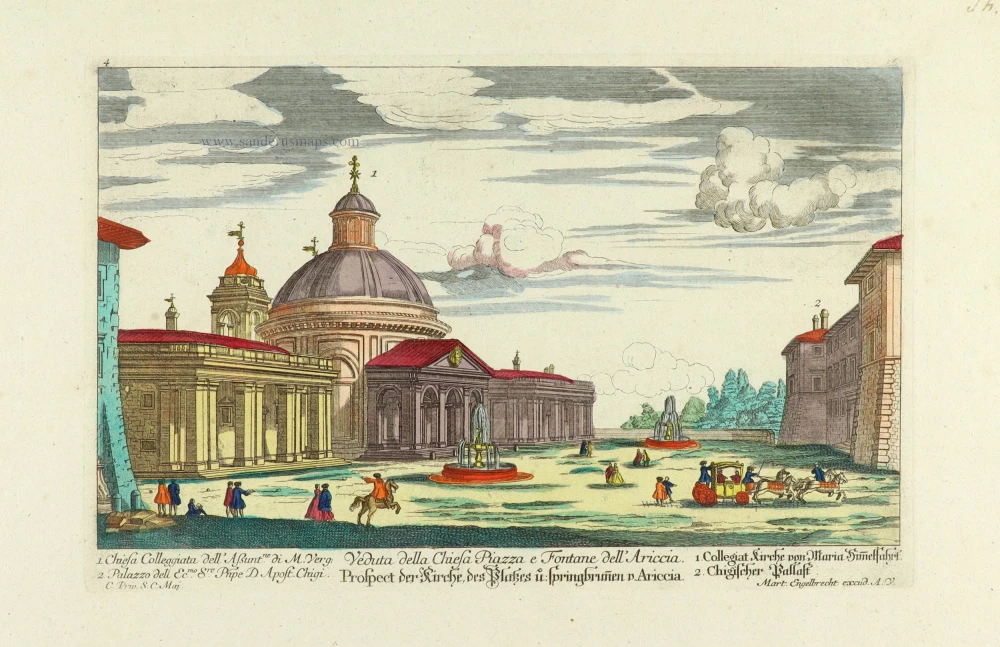
Veduta della Chiesa Piazza e Fontane dell' Ariccia. - Prospect der Kirche, des Platzes u. springbunnen v. Ariccia. c. 1750
Rome (Roma) - Church of the Assumption of Ariccia, by Martin Engelbrecht.
[Item number: 32016]

Chiesa dedicata à S. Gregorio Papa Camaldolesi sul' monte Celio. - Kirche des Heil. Bapsts Gregorii derer Camaldolenser Mönche auf dem Berge Celio. c. 1750
Rome (Roma) - Chiese del Ospitaletto, by Martin Engelbrecht after G.B. Faldi.
[Item number: 32046]

Strada che ascende al' Quirinale detta Monte Magnanapoli. - Strasse welche zum Quirinal hinauf gehet, der Berg Magnanapoli Genant. c. 1750
Rome (Roma) - Magnanapoli Esplanade, by Martin Engelbrecht after G.B. Faldi.
[Item number: 32047]
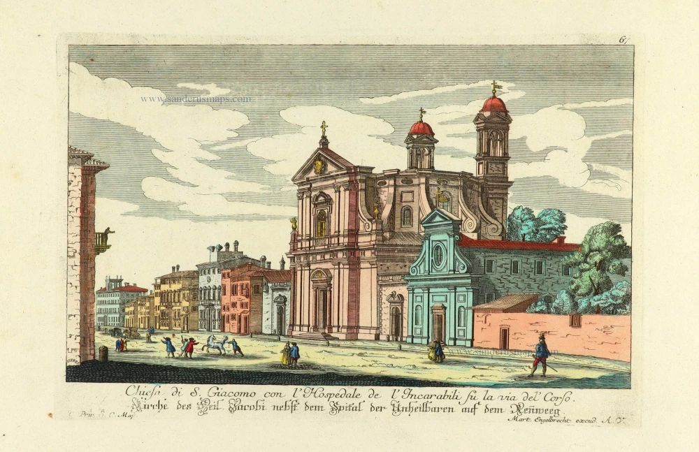
Chiesa di S. Giacomo con l'Hospedale de l'Incarabili su la via del' Corso. - Kirche des Heil. Jacobi nebst dem Spital der Unheilbaren auf dem Reñweeg. c. 1750
Rome (Roma) - Church of San Giacomo degli Incurabili, by Martin Engelbrecht after G.B. Faldi.
[Item number: 32048]

Piazza della Rotonda. - Platz della Rotonda. c. 1750
Rome (Roma) - Piazza della Rotonda with the Pantheon, by Martin Engelbrecht after G.B. Faldi.
[Item number: 32049]

Chiesa di Santa Anastasia alle radici dell' Palatine verso il Velabro. - Kirche der Heil. Anastasia am Fuß des Palatinus Bergs. c. 1750
Rome (Roma) - Chiesa di Santa Anastasia, by Martin Engelbrecht after G.B. Faldi.
[Item number: 32050]

Chiesa de Santi Vincenzo, et Anastasio alla Fintana di Trevi de Padri Religiosi di S. Girolamo. - Kirche des Heil. Vincenzij und des Heil. Anastasij beij dem Springbrunen der PP. Religiosen des Heil. Hieronijmi. c. 1750
Rome (Roma) - Church of Santi Vincenzo e Anastasio and Trevi Fountain, by Martin Engelbrecht after G.B. Faldi.
[Item number: 32051]

Chiesa de Santa Maria della Scala de PP. Carmelitani Scalzi nella Regione di Trastevere. - Kirche des Heil: Maria von der Stiegen derer PP. Carmeliter Discalceat: in der Gegend Trastevere. c. 1750
Rome (Roma) - Church of Santa Maria della Scala, by Martin Engelbrecht after G.B. Faldi.
[Item number: 32052]

Veduta della Nobil Terra dell' Ariccia Ducato dell' Ecc.mo Sig.re Prencipe d Agostino Chigi. distante dodici miglia da Roma. - Prospect des Adelsizes von Arricia, Herzogthum des Prinzen Chigi 12 Meilen von Rom gelegen. c. 1750
Ariccia (near Rome), by Martin Engelbrecht after G.B. Faldi.
[Item number: 32070]

Il Castello di S. Angelo. - Die Engelsburg. c. 1750
Rome (Roma) - Castel Sant'Angelo, by Martin Engelbrecht.
[Item number: 32071]

Chiesa di Sa Maria dell'Anima con l'Ospedale della Natione Germanica. - Kirche der H. Maria dell Anima nebst dem Spital der Teutschen Nation. c. 1750
Rome (Roma) - Church of Santa Maria dell'Anima, by Martin Engelbrecht.
[Item number: 32072]

Piazza della Colonna Trajana. - Platz der Traianischen Saüle. c. 1750
Rome (Roma) - Trajan's Forum, by Martin Engelbrecht.
[Item number: 32074]

Chiesa della Immaculata Conceptione. - Kirche von der unbefleckten Empfängnuß. c. 1750
Rome (Roma) - Church of the Immaculate Conception, by Martin Engelbrecht.
[Item number: 32075]

Chiesa di Santo Spirito in Sassia con lo Spedale de gl'infermi et Fanciuli esposti. - Kirche des Heiligen Geists in Sassia, nebst dem Krankenspital und Findel Hauß. c. 1750
Rome (Roma) - Church of the Immaculate Conception, by Martin Engelbrecht.
[Item number: 32076]

Chiesa dedicata à S. Piedro Apostolo, detto in Monte Orio sul Gianicol de Padri Reformati di San Francesco. - Kirche des H. Apostels Petri, derer Patrum Reformat. S. Francisci auf dem Berge Orio sul Gianicol genant. c. 1750
Rome (Roma) - Church of San Pietro on Montorio Piazza, by Martin Engelbrecht.
[Item number: 32079]

Chiesa sotto il Titolo di S. Maria nuova e S. Francesca Romana in Campo Vaccino. - Kirche die neüe H. Maria genant, nebst der H. Francisca Romana in Campo Vaccino. c. 1750
Rome (Roma) - Church of S. Francesca Romana, by Martin Engelbrecht.
[Item number: 32080]

Chiesa di Sant Athanagio, e Collegio della Natione de Greci. - Kirche des H. Anthanasii, und Collegium der Griechischen Nation. c. 1750
Rome (Roma) - Church of S. Athanagio, by Martin Engelbrecht.
[Item number: 32081]

Piazza e Portici della Basilica Vaticana. - Der Plaz und bedeckte Gänge der Haubt-Kirche des Vaticans. c. 1750
Rome (Roma) - St. Peter's Basilica by Martin Engelbrecht after G.B. Falda.
[Item number: 32082]

Piazza e Palazzo sul Quirinale detto Mte Cavallo. - Der Plaz und Pallast des Quirinals genandt Monte Cavallo. c. 1750
Rome (Roma) - Piazza di Monte Cavallo by Martin Engelbrecht after G.B. Falda.
[Item number: 32085]
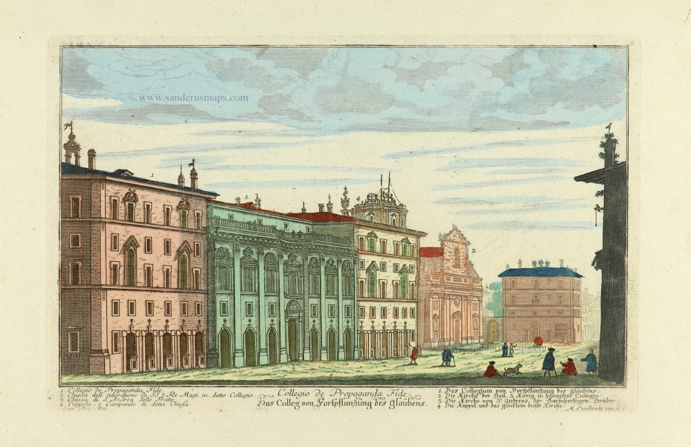
Collegio de Propaganda Fide. - Das Colleg: von Forspflanzüng des Glaubens. c. 1750
Rome (Roma) - Collegio di Propaganda Fide and church of Re Magi. by Martin Engelbrecht after G.B. Falda.
[Item number: 32086]
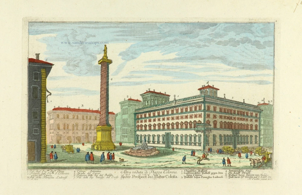
Altra veduta di Piazza Colonna. - Ander Prospect des Plazes Coloña. c. 1750
Rome (Roma) - Trajan's Forum by Martin Engelbrecht after G.B. Falda.
[Item number: 32087]

Chiesa della Santiss: Trinita de Monti de PP. Minimi Francesi sul' Monte Pincio. - Kirche der Heil: Dreijeinigheit de Monti derer Franßösischen Minen brüder auf dem Berg Pincio. c. 1750
Rome (Roma) - Church of the Trinita dei Monti by Martin Engelbrecht after G.B. Falda.
[Item number: 32088]

Fontana e Castello sul Monte Viminale. - Springbruñe und Castell auf dem Berg Minimale. c. 1750
Rome (Roma) - Fontana e Castello sul Monte Viminale by Martin Engelbrecht after G.B. Falda.
[Item number: 32089]

Fontana e Castello dell' Aqua Paolo. - Springbruñe und Castell von Aqua Paolo. c. 1750
Rome (Roma) - Fontana e Castello dell' Aqua Paolo, by Martin Engelbrecht after G.B. Faldi.
[Item number: 32125]

Altra Veduta della Fontana e Castello dell' Aqua Paolo. - Anderseitiger Prospect des Springbruñens und Castell von Aqua Paolo. c. 1750
Rome (Roma) - Fontana e Castello dell' Aqua Paolo, by Martin Engelbrecht after G.B. Faldi.
[Item number: 32126]

Strada dalla Piazza di S. Marco alla Chiesa del' Giesu. - Straße von dem Pallast S. Marco, zu der Jesus Kirche. c. 1750
Rome (Roma) - Via del Plebiscito, which connects Piazza Venezia to Piazza de Gesù, by Martin Engelbrecht after G.B. Faldi.
[Item number: 32127]

Chiesa di Santa Maria in Via lata su la Via del' Corsi. - Kirche der Heil. Maria in der breiten Straße, auf dem Reñweeg. c. 1750
Rome (Roma) - Church Santa Maria in Via Lata, by Martin Engelbrecht after G.B. Faldi.
[Item number: 32128]

Piazza del Collegio Rom.o - Plazz des Römischen Collegii. c. 1750
Rome (Roma) - Piazza del Collegio Romanum, by Martin Engelbrecht after G.B. Faldi.
[Item number: 32129]

Piazza e Chiesa di S. Carlo alli Catinari. - Plazz u[nd] Kirche des Heil. Caroli alli Catinari. c. 1750
Rome (Roma) - Church of San Carlo ai Catinari, by Martin Engelbrecht after G.B. Faldi.
[Item number: 32130]