
ITALY by Petrus Schenk c. 1700

The Valk Family
Gerard Valk (Valck) (1652-1726) was Amsterdam's publisher, engraver, art seller, and globemaker. He was trained under Abraham Bloteling, later becoming his assistant. The two moved to London, where Valk worked with various map and print sellers. He married Abraham's sister, Maria Bloteling, in London around 1673; in that city, his son and successor, Leonard, was born in 1675.
Not long after, Bloteling and Valk returned to Amsterdam, where Gerard Valk was registered as a burgher on December 8, 1679.
Around 1680 he began working with the German engraver Petrus Schenk as an engraver, publisher, map and print-sellers. They acquired the plates for the Janssonius Novus Atlas and Sanson's maps. Although they never shared premises, they worked closely together in the publications of editions of these works. Valk and his son Leonard are best known for their globemaking. In addition to globes newly compiled from the latest geographical and astronomical information, the Valk's published theoretical works on astronomy and globes.
In 1710, the family tie between the two partners, Valk and Schenk, became even closer when Gerard's son Leonard Valk (1675-1746) married Maria Schenk (1688-1770), Petrus' daughter.
After the death of Gerard in 1726, the business continued in the hands of his son Leonard and Gerard's widow Maria until she died in 1729, and then by Leonard until he died in 1746.
The Schenk Family
Petrus Schenk (1660-1718), the founder of one of the best-known publishing firms of Amsterdam in the 18th century, was born in Elberfeld, Germany, in 1660. He went to Amsterdam, where he became a pupil of the engraver Gerard Valck. On 19 Nov. 1686, a privilegio was granted to Petrus Schenk and Gerard Valk for the manufacturing and selling their prints—Schenk’s contribution to cartography dates from c. 1695. In 1706, he moved to the Vijgendam in Amsterdam, ‘in Sanson’s Atlas’. After he died in 1718, his son, Leonardus Schenk, continued the art and print shop. The second son, Petrus II (1693-1775), settled in another famous house: ‘in Visscher’s Atlas’, where he continued associating with Gerard and Leonarus Valck.
The Schenk family produced general geographical atlases and special atlases. Apart from seventy original maps, several hundred are known as Schenk, printed from plates obtained from Janssonius and Visscher. Schenk and Valck acquired all the plates of the Janssonius Heir’s Novus Atlas, including the Celestial Atlas. Many of Janssonius’ plates were reworked and amended.
Republishing maps from Janssonius’ Novus Atlas since c. 1680 was followed by engraving new maps copied from Sanson’s better and more modern maps. Petrus Schenk published these maps in his Atlas Contractus sive mapparum geographicarum Sansoniarum auctarum et correctum Nova Congeries, also called Atlas Minor. After 1719, Petrus Schenk II continued the Atlas Contractus.
Petrus Schenk, the elder, enjoyed great fame as a print seller and artist among art and print dealers in the whole of Europe. The great activity in map publishing, displayed by Petrus Schenk, the elder, was continued by his son and grandson. But the number of original atlas maps is small. Like his father, who bought the copperplates of Janssonius’ atlas, Petrus Schenk II bought many of the plates formerly owned by Nicolaas Visscher.
Apart from the globes, maps and atlases, Petrus Schenk II published many books. In 1733, he was older men of the booksellers guild in 1733.
Petrus Schenk Junior (1728-1803) was an engraver and artseller. He continued to publish many of the titles his father and grandfather issued, and the globes of his uncle Leonard Valk.
Nicolas Sanson (1600-1667) - Guillaume Sanson (1633-1703)
Originally from Abbeville, Nicolas I Sanson showed a keen interest in historical geography. Still very young, he published a map of ancient Gaul and two treatises, Britannia and Portus Itius on Abbeville and Boulogne's origins. His meeting with Melchior Tavernier was decisive: it prompted him to give up his duties as a military engineer in Picardy and devote himself to engraved cartography.
At the same time, Sanson had drawn up the outline of modern France. He got the help of Tavernier who encouraged him to compete with the Dutch map publishers. Tavernier contacted other French cartographers whose works he published.
From 1643, N. Sanson obtained a privilege to publish a work personally, the Princes souverains de l'Italie. Then, in 1644 and 1645, he had his famous geographical tables printed, which significantly contributed to his fame. He also published a series of atlases in quarto of the four continents.
In 1648, N. Sanson associated himself with Mariette for the publishing of atlases. From then on, certain maps bore his name, and others Mariette's. N. Sanson and Mariette worked together for more than 20 years. After the death of N. Sanson, Mariette acquired the entire fund. Since Mariette only wanted to publish complete atlases, individual maps were no longer sold, and some army generals complained to the king.
The disagreement between the Sanson family and Pierre II Mariette culminated in 1671 when Guillaume Sanson took the case to court. From then on, there was no longer any question of collaboration: Guillaume Sanson started working for another publisher, Alexis-Hubert Jaillot.
The Sanson family faced financial difficulties, and in 1692, their cousin, Pierre Moullart-Sanson, bought the entire geographic fund from his uncles and aunt. Moullart-Sanson restarted the publishing of Sanson's world atlas, and in 1704 he acquired a privilege for publishing all the works of Nicolas and Guillaume Sanson, which continued to be published until 1730.
L!talie divisee suivant l'estendue de toutes ses souverainetes qui sont les estats de l'Eglise du Roy Catholique ... - L'Italie distinguee juivant l'Estendiie de tous les Estats Royaumes Republiques duchés principautés. Par le S. Sanson.
Item Number: 19102 Authenticity Guarantee
Category: Antique maps > Europe > Italy
Old, antique map of Italy by Nicolas Sanson, published by Petrus Schenk.
Mappa antica d'Italia, di Nicolas Sanson, pubblicata da Petrus Schenk.
Cartographer: Nicolas Sanson
Copper engraving, printed on paper.
Size (not including margins): 49 x 57.5cm (19 x 22.4 inches)
Verso: Blank
Condition: Original coloured, some creasing along centrefold, lower centrefold reinforced.
Condition Rating: B+
References: Borri, #154.
From: Atlas Contractus sive Mapparum Geographicarum Sansoniarum auctarum et correctarum Nova Congeries. Amsterdam, Petrus Schenk, c. 1700. (Koeman, Sche 1)
The Valk Family
Gerard Valk (Valck) (1652-1726) was Amsterdam's publisher, engraver, art seller, and globemaker. He was trained under Abraham Bloteling, later becoming his assistant. The two moved to London, where Valk worked with various map and print sellers. He married Abraham's sister, Maria Bloteling, in London around 1673; in that city, his son and successor, Leonard, was born in 1675.
Not long after, Bloteling and Valk returned to Amsterdam, where Gerard Valk was registered as a burgher on December 8, 1679.
Around 1680 he began working with the German engraver Petrus Schenk as an engraver, publisher, map and print-sellers. They acquired the plates for the Janssonius Novus Atlas and Sanson's maps. Although they never shared premises, they worked closely together in the publications of editions of these works. Valk and his son Leonard are best known for their globemaking. In addition to globes newly compiled from the latest geographical and astronomical information, the Valk's published theoretical works on astronomy and globes.
In 1710, the family tie between the two partners, Valk and Schenk, became even closer when Gerard's son Leonard Valk (1675-1746) married Maria Schenk (1688-1770), Petrus' daughter.
After the death of Gerard in 1726, the business continued in the hands of his son Leonard and Gerard's widow Maria until she died in 1729, and then by Leonard until he died in 1746.
The Schenk Family
Petrus Schenk (1660-1718), the founder of one of the best-known publishing firms of Amsterdam in the 18th century, was born in Elberfeld, Germany, in 1660. He went to Amsterdam, where he became a pupil of the engraver Gerard Valck. On 19 Nov. 1686, a privilegio was granted to Petrus Schenk and Gerard Valk for the manufacturing and selling their prints—Schenk’s contribution to cartography dates from c. 1695. In 1706, he moved to the Vijgendam in Amsterdam, ‘in Sanson’s Atlas’. After he died in 1718, his son, Leonardus Schenk, continued the art and print shop. The second son, Petrus II (1693-1775), settled in another famous house: ‘in Visscher’s Atlas’, where he continued associating with Gerard and Leonarus Valck.
The Schenk family produced general geographical atlases and special atlases. Apart from seventy original maps, several hundred are known as Schenk, printed from plates obtained from Janssonius and Visscher. Schenk and Valck acquired all the plates of the Janssonius Heir’s Novus Atlas, including the Celestial Atlas. Many of Janssonius’ plates were reworked and amended.
Republishing maps from Janssonius’ Novus Atlas since c. 1680 was followed by engraving new maps copied from Sanson’s better and more modern maps. Petrus Schenk published these maps in his Atlas Contractus sive mapparum geographicarum Sansoniarum auctarum et correctum Nova Congeries, also called Atlas Minor. After 1719, Petrus Schenk II continued the Atlas Contractus.
Petrus Schenk, the elder, enjoyed great fame as a print seller and artist among art and print dealers in the whole of Europe. The great activity in map publishing, displayed by Petrus Schenk, the elder, was continued by his son and grandson. But the number of original atlas maps is small. Like his father, who bought the copperplates of Janssonius’ atlas, Petrus Schenk II bought many of the plates formerly owned by Nicolaas Visscher.
Apart from the globes, maps and atlases, Petrus Schenk II published many books. In 1733, he was older men of the booksellers guild in 1733.
Petrus Schenk Junior (1728-1803) was an engraver and artseller. He continued to publish many of the titles his father and grandfather issued, and the globes of his uncle Leonard Valk.
Nicolas Sanson (1600-1667) - Guillaume Sanson (1633-1703)
Originally from Abbeville, Nicolas I Sanson showed a keen interest in historical geography. Still very young, he published a map of ancient Gaul and two treatises, Britannia and Portus Itius on Abbeville and Boulogne's origins. His meeting with Melchior Tavernier was decisive: it prompted him to give up his duties as a military engineer in Picardy and devote himself to engraved cartography.
At the same time, Sanson had drawn up the outline of modern France. He got the help of Tavernier who encouraged him to compete with the Dutch map publishers. Tavernier contacted other French cartographers whose works he published.
From 1643, N. Sanson obtained a privilege to publish a work personally, the Princes souverains de l'Italie. Then, in 1644 and 1645, he had his famous geographical tables printed, which significantly contributed to his fame. He also published a series of atlases in quarto of the four continents.
In 1648, N. Sanson associated himself with Mariette for the publishing of atlases. From then on, certain maps bore his name, and others Mariette's. N. Sanson and Mariette worked together for more than 20 years. After the death of N. Sanson, Mariette acquired the entire fund. Since Mariette only wanted to publish complete atlases, individual maps were no longer sold, and some army generals complained to the king.
The disagreement between the Sanson family and Pierre II Mariette culminated in 1671 when Guillaume Sanson took the case to court. From then on, there was no longer any question of collaboration: Guillaume Sanson started working for another publisher, Alexis-Hubert Jaillot.
The Sanson family faced financial difficulties, and in 1692, their cousin, Pierre Moullart-Sanson, bought the entire geographic fund from his uncles and aunt. Moullart-Sanson restarted the publishing of Sanson's world atlas, and in 1704 he acquired a privilege for publishing all the works of Nicolas and Guillaume Sanson, which continued to be published until 1730.
Related items
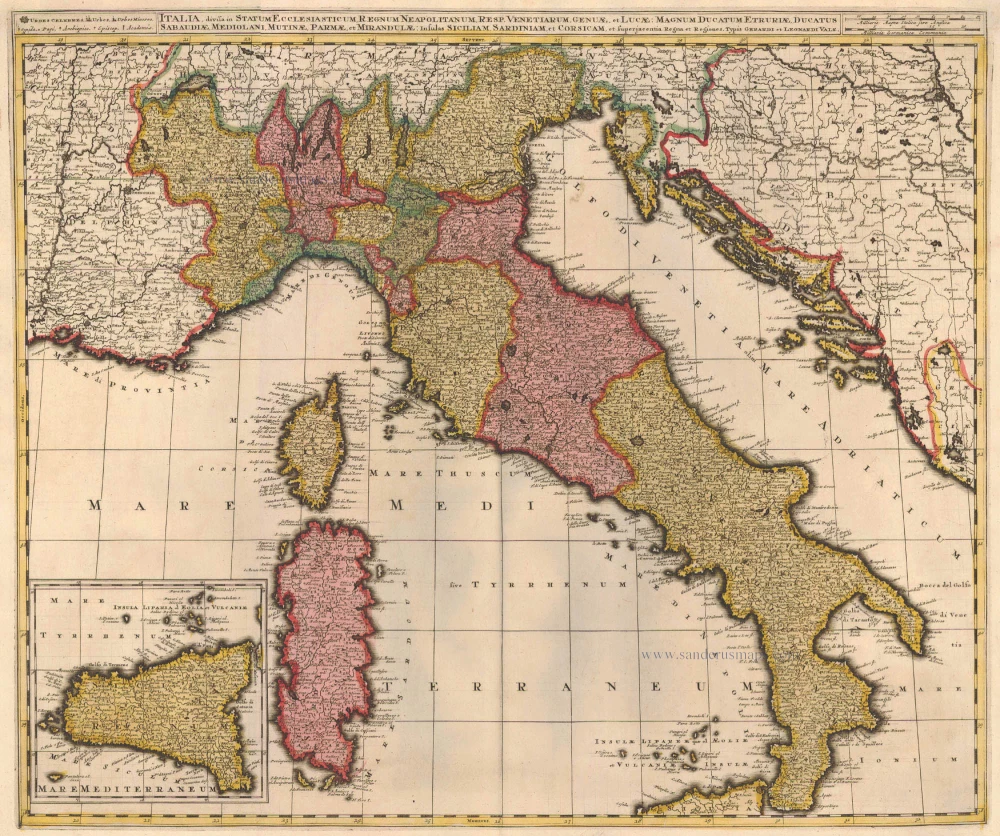
Italia, Divisa in Statum Ecclesiasticum, Regnum Neapolitanum, Resp. Venetiarum, Genuae, et Lucae: Magnum Ducatum Etruriae, Ducatus Sabaudiae, Mediolani, Mutinae, Parmae et Mirandulae: Insulas Siliciam, Sardiniam, et Superjacentia Regna et Regiones c. 1730.
Italy, by Valk G.& L.
[Item number: 14145]
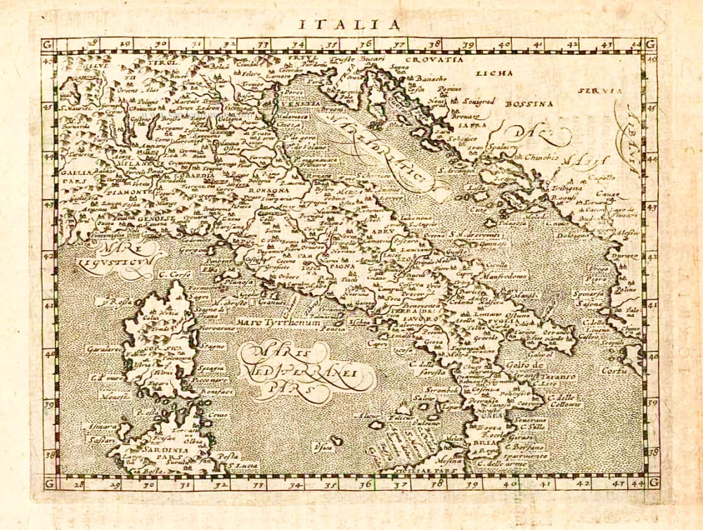
Italia. 1597
Italy, by Giovanni Magini.
[Item number: 26517]
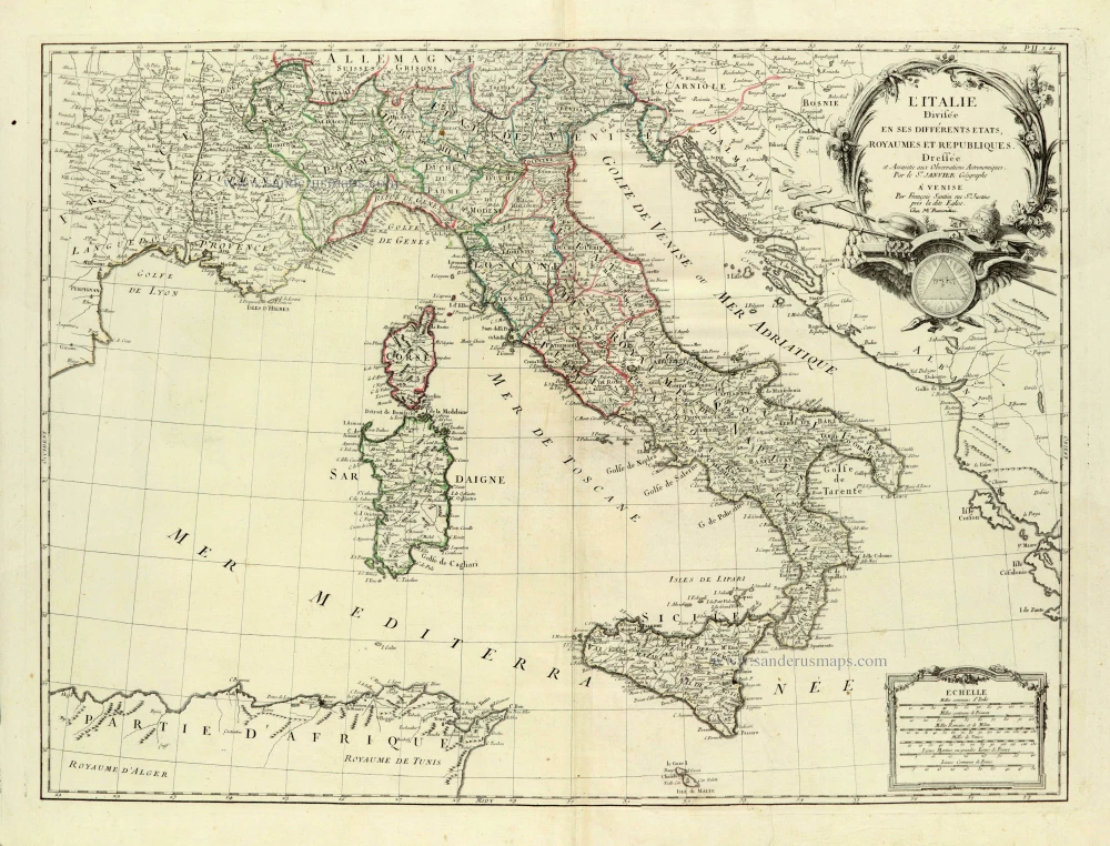
L'Italie Divisée en ses différents Etats, Royaumes et Républiques. 1776-79
Italy, by Sr. Janvier Jean Denis.
[Item number: 28076]