This product is successfully added to your cart
Questions about this product? (#29501)

Authenticity Guarantee
All items are guaranteed authentic prints (woodcuts or engravings) or manuscripts made at or about (c.) the given date and in good condition unless stated otherwise. We don’t sell facsimiles or reproductions. We deliver every map with a Certificate of Authenticity containing all the details.

Ptolemy map of Italy published by C. Beneventano & C. Cotta for B. de Vitalibus. 1507
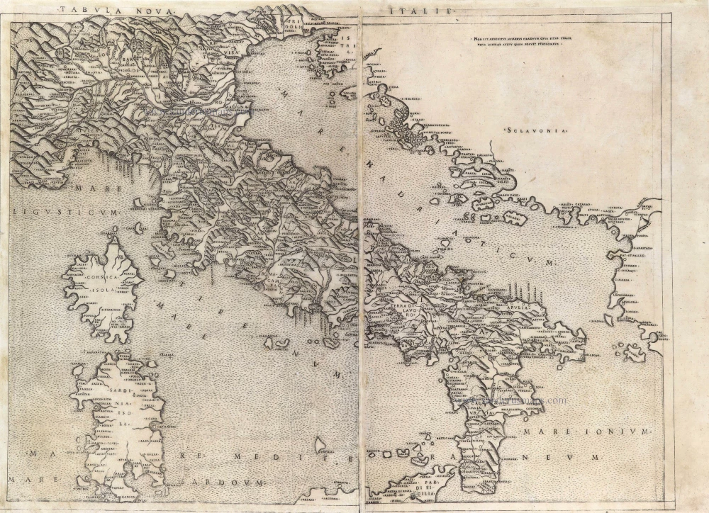
Ptolemy map of Italy published by C. Beneventano & C. Cotta for B. de Vitalibus.

Scarce map of modern Italy from one of the first Ptolemy editions with copper engraved maps. 
This map was only published in the third (of 4) Rome edition of 1507, without degrees numbers added in the 1508 edition.
One of the six new maps that were added in the third Rome edition.


Claudius Ptolemy   (c.100 – c.170 AD)

Claudius Ptolemy was a Greek-speaking scholar who lived in Alexandria during the second century CE, under Roman rule. Active around 100–170 CE, Ptolemy is regarded as one of the most influential astronomers, geographers, and mathematicians of the ancient world. His writings shaped scientific thought for more than a thousand years and formed a cornerstone of both Islamic and European scholarship during the Middle Ages and the Renaissance.

Ptolemy is best known for two monumental works: the Almagest, which presented the geocentric model of the universe, and the Geographia, a systematic study of world geography. In the Geographia, he compiled coordinates for thousands of places and introduced methods for projecting the curved surface of the earth onto a flat map. Although many of his measurements were inaccurate by modern standards, his use of latitude and longitude established a scientific framework that profoundly influenced the history of cartography.

Ptolemy’s works survived through Byzantine and Islamic scholars before being rediscovered in Renaissance Europe, where they inspired a renewed interest in mathematics, astronomy, and mapmaking. Printed editions of the Geographia, including the famous Ulm editions of 1482 and 1486, brought his ideas to a wider audience and became foundational texts in the development of early modern geography.

Today, Ptolemy is remembered not only for the accuracy of his observations but also for his ambition to organise and describe the known world through mathematics and reason. His legacy marks a crucial bridge between the scientific traditions of antiquity and the intellectual revival of the Renaissance.

back

Tabula nova Italie.

SOLD

Item Number:  29501 Authenticity Guarantee

Category:  Antique maps > Europe > Italy

Old, antique map of Italy, by Claudius Ptolemy.

Title: Tabula nova Italie.

Cartographer: Agostino de Musi (Attributed).

Date of the first edition: 1507.
Date of this map: 1507.

Copper engraving, printed on paper.
Map size: 410 x 545mm (16.14 x 21.46 inches).
Sheet size: 415 x 575mm (16.34 x 22.64 inches).
Verso: Blank.
Condition: Printed from two plates, joined, upper margin extended with reinstatement of 2mm of the top of the mountains, and of the top of the word "ITALIE", new left margin with reinstatement of the two neatlines and 3-5mm of the image.


From: Ptolemaeus Cl. In Hoc Operae Haec Contine[n]tur Geographia Cl. Ptholemaei ... Romae ... M.D.VII [1507]. (Shirley (Brit.Lib.) T.Ptol-2f)

Scarce map of modern Italy from one of the first Ptolemy editions with copper engraved maps. 
This map was only published in the third (of 4) Rome edition of 1507, without degrees numbers added in the 1508 edition.
One of the six new maps that were added in the third Rome edition.


Claudius Ptolemy   (c.100 – c.170 AD)

Claudius Ptolemy was a Greek-speaking scholar who lived in Alexandria during the second century CE, under Roman rule. Active around 100–170 CE, Ptolemy is regarded as one of the most influential astronomers, geographers, and mathematicians of the ancient world. His writings shaped scientific thought for more than a thousand years and formed a cornerstone of both Islamic and European scholarship during the Middle Ages and the Renaissance.

Ptolemy is best known for two monumental works: the Almagest, which presented the geocentric model of the universe, and the Geographia, a systematic study of world geography. In the Geographia, he compiled coordinates for thousands of places and introduced methods for projecting the curved surface of the earth onto a flat map. Although many of his measurements were inaccurate by modern standards, his use of latitude and longitude established a scientific framework that profoundly influenced the history of cartography.

Ptolemy’s works survived through Byzantine and Islamic scholars before being rediscovered in Renaissance Europe, where they inspired a renewed interest in mathematics, astronomy, and mapmaking. Printed editions of the Geographia, including the famous Ulm editions of 1482 and 1486, brought his ideas to a wider audience and became foundational texts in the development of early modern geography.

Today, Ptolemy is remembered not only for the accuracy of his observations but also for his ambition to organise and describe the known world through mathematics and reason. His legacy marks a crucial bridge between the scientific traditions of antiquity and the intellectual revival of the Renaissance.

References: Borri (Italia, 2010) - p. 44, #22 Rarita 92; Bifolco-Ronca (Cart. Italiana XVI s.) - p. 1806, #906.1 - State 1 of 3.