
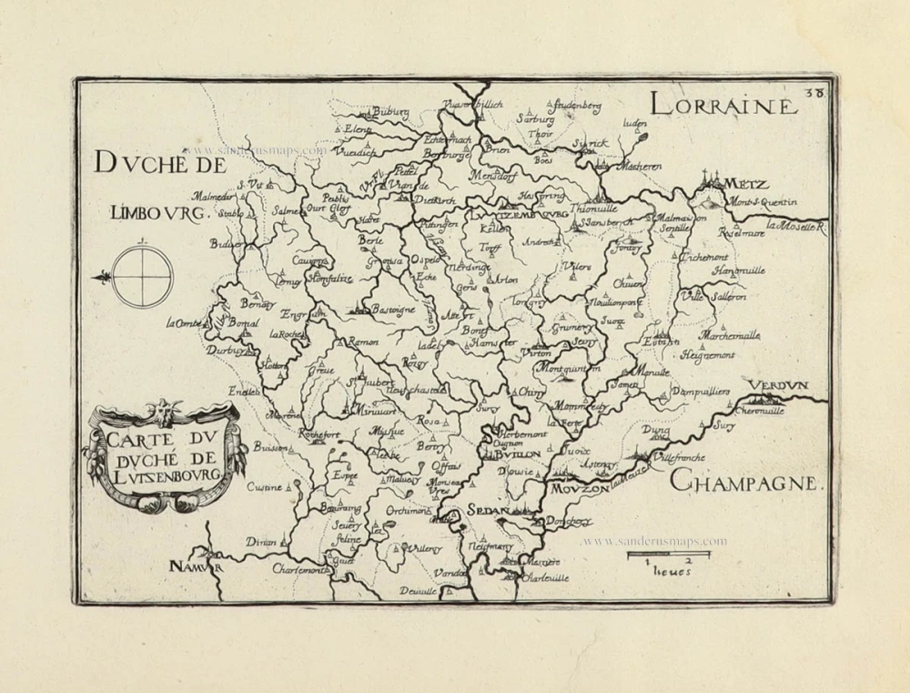
Luxembourg, by Frederick de Wit. ca. 1707-10


Frederick de Wit (1630-1706)
The engraver and map-seller, Frederick de Wit, was born in Gouda (Netherlands) in 1630 as a son of Hendrick Fredericksz de Wit. Through his marriage with Maria van der Waag of Amsterdam in 1661, he obtained citizenship of the city where he had been working since 1648 and where he became one of the most famous engravers of maps of the second half of the 17th century. Although De Wit was a Catholic, which meant that he was not favoured at the time by the city council, he was awarded the honour of being listed as one of the "excellent citizens" on the roll of the city council in the years 1694-1704. However, his name was not written in the Guild of St. Luke book before 1664. At that time, he lived on the Kalverstraat "in de Witte Pascaert", where he stayed until his death in 1706. His earliest dates on maps engraved are 1659 (Regni Daniae) and 1660 (World map).
Frederick de Wit published several world atlases, a sea atlas, and an atlas of the Netherlands.
The dating of the maps is difficult. However, as a privilege was granted in 1689, the annotation 'cum privilegio' marks an edition after 1688.
Around 1700, Frederick de Wit entered the market with a town atlas. He produced two volumes with a total of 260 plans and views. Most were printed from plates used for Janssonius and Blaeu town atlases.
After he died in 1706, his widow continued the shop until 1709. The plates and stock of De Wit's atlas were sold to Covens & Mortier in 1710, who sold the atlas for an extended period.
Ducatus Lutzenburgici Tabula Nuperrimi in Lucem Edita per Fredericum De Wit.
Item Number: 29006 Authenticity Guarantee
Category: Antique maps > Europe > Luxembourg
Antique map of Luxembourg, by Frederick de Wit.
Title: Ducatus Lutzenburgici Tabula Nuperrimi in Lucem Edita per Fredericum De Wit.
't Amsterdam by Frederick de Wit, inde Calverstraet by den Dam inde Witte Pascaert.
Oriented to the northwest.
Date of the first edition: ca. 1666-67.
Date of this map: ca. 1707-10.
Copper engraving, printed on paper.
Map size: 465 x 560mm (18.31 x 22.05 inches).
Sheet size: 540 x 635mm (21.26 x 25 inches).
Verso: Blank.
Condition: Original coloured, excellent.
Condition Rating: A+.
From: Atlas. Amsterdam, Frederick de Wit, after 1705. (Koeman, III p. 202, Wit16; Carhart p. 159 A157)
Frederick de Wit (1630-1706)
The engraver and map-seller, Frederick de Wit, was born in Gouda (Netherlands) in 1630 as a son of Hendrick Fredericksz de Wit. Through his marriage with Maria van der Waag of Amsterdam in 1661, he obtained citizenship of the city where he had been working since 1648 and where he became one of the most famous engravers of maps of the second half of the 17th century. Although De Wit was a Catholic, which meant that he was not favoured at the time by the city council, he was awarded the honour of being listed as one of the "excellent citizens" on the roll of the city council in the years 1694-1704. However, his name was not written in the Guild of St. Luke book before 1664. At that time, he lived on the Kalverstraat "in de Witte Pascaert", where he stayed until his death in 1706. His earliest dates on maps engraved are 1659 (Regni Daniae) and 1660 (World map).
Frederick de Wit published several world atlases, a sea atlas, and an atlas of the Netherlands.
The dating of the maps is difficult. However, as a privilege was granted in 1689, the annotation 'cum privilegio' marks an edition after 1688.
Around 1700, Frederick de Wit entered the market with a town atlas. He produced two volumes with a total of 260 plans and views. Most were printed from plates used for Janssonius and Blaeu town atlases.
After he died in 1706, his widow continued the shop until 1709. The plates and stock of De Wit's atlas were sold to Covens & Mortier in 1710, who sold the atlas for an extended period.
Related items

Luceburgum. 1649
Luxembourg, by Joan Blaeu.
[Item number: 105]

Luxembourg - Lutzenburgum, Ducatus eiusdem Nominis, Vetus et Primaria Urbs ... 1657
Luxembourg, by J. Janssonius.
[Item number: 9528]

Luxemburgensis Ducatus, tam in ejusdem Minores, quam Principales, ... 1683-1696
Luxembourg, by N. Visscher II.
[Item number: 14831]

Lutzenburgensis Ducatus Veriss. Descript. 1579
Luxembourg, by A. Ortelius.
[Item number: 21720]

Lutzenburgensis Ducatus Veriss. Descript. 1598
Luxembourg, by A. Ortelius.
[Item number: 22910]

Luxembourg - Lutzenburgum, Ducatus eiusdem Nominis, Vetus et Primaria Urbs ... 1581-88
Luxembourg by Georg Braun & Frans Hogenberg
[Item number: 23308]

Trier & Lutzenburg 1623
Luxembourg and Trier, by Gerard Mercator.
[Item number: 24918]

Lutzenburgum. 1652
Luxembourg by Joan Blaeu
[Item number: 25512]

Lutzenburgensis Ducatus Veriss. Descript. 1634
Luxembourg by P. Kaerius (Van den Keere), published by C.J. Visscher.
[Item number: 29610]

Ducatus Lutzenburgi Novissima et accuratissima delineatio, c. 1658
Luxembourg by Nicolaas Visscher I.
[Item number: 29979]

Trevirensis Archiepiscopatus, et Lutzenburgi Ducatus. c. 1630-1650
Trier - Luxembourg by Blaeu W. & J.
[Item number: 30845]

Luxenburgicus ducatus, septem Comitatibus distinctus, milliaria LXX continens, preter Oppida et castra, Urbes moeniorum ambitu firmas; Pagos M.C.LXIX, et frequentem nobilitatem exhibet, eiusdemque adpellatiorus Metropoli inclarescit. c. 1620-26
Luxembourg by Jean Leclerc.
[Item number: 30898]

Lutzenburgensis Ducatus Veriss. Descript. c. 1610-1650
Luxembourg by P. Kaerius (Van den Keere), published by C.J. Visscher.
[Item number: 30933]

Lucenburgum Urbs eiusdem nominis Ducatus primaria et Tribunam supremum, montoso inaequali situ spectabilis. 1623
Luxembourg, by Georg Braun & Frans Hogenberg.
[Item number: 31261]

Lutzenburg. 1618
Luxembourg by Petrus Bertius, published by Jodocus Hondius II.
[Item number: 31586]
Carte du Duché de Lutsenbourg 1633
Luxembourg by Christophe Tassin.
[Item number: 32011]

Lutzenbourg - Lutzenburgu[m] Ducatus eiusde[m] nominis, vetus et primaria urbis, in superiore[m] et inferiorem situ mirabili, ... 1612
Luxembourg by Lodovico Guicciardini
[Item number: 33021]