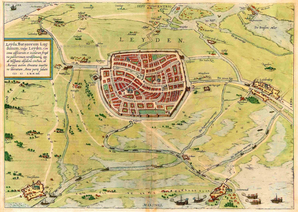
Antique map of Leiden by Braun & Hogenberg 1575
Leyda, Batavorum Lugdunum, vulgo Leyden, ...
Item Number: 5451 Authenticity Guarantee
Category: Antique maps > Europe > The Netherlands - Cities
Bird's-eye view plan by Braun and Hogenberg, showing Leiden and surrounds with Valkenburg, Voorschoten, Zoeterwoude, Leiderdorp, etc ...
TRANSLATION OF CARTOUCHE TEXT: Leiden, the Lugdunum of the Batavi, in the vernacular Leyden. A town that is beautiful and splendid due to its elegant houses and large population; besieged and surrounded by the Spanish, but relieved through the supply of provisions by the Orange party in the year of salvation 1574.
COMMENTARY BY BRAUN: "In Leiden there exists up to the present day a lively trade in wool and cloth, but also in hides and excellent parchment, which are treated and produced here. The city is three miles from Delft and not far from the old Britannic castle, which can still be seen today when the sea recedes a little."
The unusual bird's-eye view from the south shows Leiden with its orderly canals, and the surrounding countryside with the villages of Voorchoten (left), Leiderdorp (right) and Zoeterwoude (bottom right). In the 16th and 17th centuries Leiden experienced an economic and political upturn. After an unsuccessful five-month siege (the fighting can be seen in the lower right-hand corner) the Spanish withdrew in the autumn of 1574. As a reward, William of Orange founded the university in 1575. The cloth trade boomed and at the beginning of the 17th century Leiden had 100,000 inhabitants. Many opulent Renaissance buildings were constructed in this period, including the town hall, the Gemeenlandshuis and the Lakenhal. The Sint-Pieterskerk was completed in the 16th century in the late Gothic style.
This map was made by the Dutch cartographer Jan van Liefrinck, who was active in Leiden in 1567 and died there in 1599. He received payment on 22 August 1580 from the Leiden Magistracy for his map and view of the city, which was destined for Plantijn's edition of Guicciardini's Descrittione, 1581.
First state: the map has still its original size (in the second state, the plate is trimmed at the bottom for 15 mm and at right for 25 mm).
Copper engraving
Size: 35.5 x 50cm (13.8 x 19.5 inches)
Verso text: Latin
Condition: Old coloured, slight browning along centrefold.
Condition Rating: B+
References: Van der Krogt 4, 2271, State 1; Taschen, Braun and Hogenberg, p.156.
From: Civitates Orbis Terrarum, ... Part 2: De Praecipuis, Totius Universi Urbibus, Liber Secundus. Köln, Gottfried von Kempen, 1575. (Van der Krogt 4, 41:1.2)

