
Antique map of Maastricht by Braun & Hogenberg 1575-1612


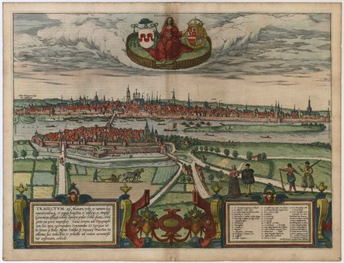
Traiectum ad Mosam, urbs et natura loci, ...
Item Number: 7541 Authenticity Guarantee
Category: Antique maps > Europe > The Netherlands - Cities
Bird's-eye view of Maastricht with key to locations.
Translation cartouche left: Maastricht, a city that is well known because of its natural position, its fortifications, the size of its population, its buildings and great collegiate foundations, reveals itself as a double city joined by a magnificent bridge.
Commentary by Braun: Tricht is a large city, situated on both sides of the Meuse, joined by a fine stone bridge with ten arches. The part of the city that lies on the east bank is called Wyck. The city is subject in part to the bishop of Liège and in part to the Duke of Brabant, who is currently the invincible King of Spain, Philip. The main church is the Collegium of St Servatius, in which the relics of St Servatius and many other saints are kept.
The Traiectum ad Mosam - "crossing over the Meuse" - gave Maastricht its name, and the city is shown in a view from the east over the Wyck and the Meuse in bird's-eye perspective: on the right, above the 160-m-long stone bridge from the 13th century, we see first the Sint-Servaas basilica, on the left to the high tower of the late Gothic Sint-Janskerk (3) and further to the left the late Romanesque Onze-Lieve-Vrouwe church from the 11th/12th centuries (2). From 1284 onwards Maastricht was under the rule of the Dukes of Brabant and the prince-bishops of Liège. A major historical event was the conquest and looting of Maastricht by the Spanish during the Dutch Revolt on 1579. (Taschen)
Copper engraving
Size: 37 x 39.5cm (14.4 x 15.4 inches)
Verso text: Latin
Condition: Old coloured, slight browning along upper centrefold.
Condition Rating: B+
References: Taschen, Braun and Hogenberg, p.160.
From: Civitates Orbis Terrarum, ... Part 2. Köln, 1575-1612.