
Old, antique map of Harderwijk by Braun & Hogenberg 1623
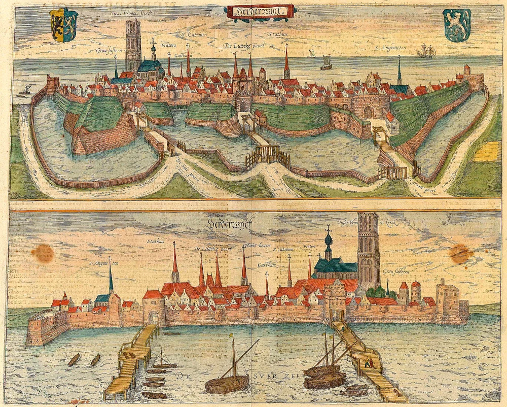
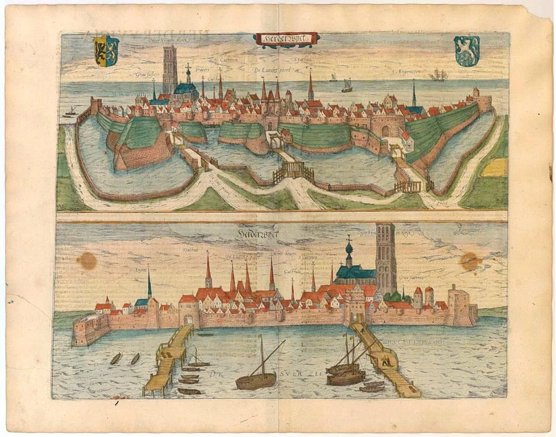


COMMENTARY BY BRAUN: "Harderwijk is a town in the Duchy of Guelders that lies on a curving bay and that is everywhere praised for its safe and attractive situation. If one looks south, one sees its rich fishing waters; looking north, there are woods and gardens, farmland suitable for cultivation and fertile fields. When one looks at the town itself, one is instantly struck by the magnificent buildings belonging both to nobles and to rich merchants. The church is dedicated to the Virgin, but in these difficult time it has thrice been plundered. It has a tower that also serves as a lighthouse, which sailors often use for orientation." The small port of Harderwijk on the Zuiderzee (today the IJsselmeer Lake) is reproduced in two magnificent complementary views. In the top illustration, the town is seen from a slightly elevated perspective from the southeastern mainland, while the bottom illustration shows the view from the Zuiderzee to the northwest, as if from an arriving ship. Particularly striking on the landward side are the massive fortified walls and bulwarks that surround the town, while its wide moat, which can be crossed only via drawbridges, makes it resemble an island. Harderwijk is first documented in 1231, when it was granted its municipal charter. In the 15th century the major fishing town and port joined the Hanseatic League. From this era dates the late Gothic Onze Lieve Vrouwe church, with its distinctive tower, which was renamed the Grote Kerk in 1578, in the wake of the Reformation. In 1584 Harderwijk, which enjoyed overland access to the Rhine via a cart track, was granted the right to mint its own regional coins. (Taschen)
Braun G. & Hogenberg F. and the Civitates Orbis Terrarum.
The Civitates Orbis Terrarum, also known as the 'Braun & Hogenberg', is a six-volume town atlas and the most excellent book of town views and plans ever published: 363 engravings, sometimes beautifully coloured. It was one of the best-selling works in the last quarter of the 16th century. Georg Braun, a skilled writer, wrote the text accompanying the plans and views on the verso. Many plates were engraved after the original drawings of a professional artist, Joris Hoefnagel (1542-1600). The first volume was published in Latin in 1572 and the sixth in 1617. Frans Hogenberg, a talented engraver, created the tables for volumes I through IV, and Simon van den Neuwel made those for volumes V and VI. Other contributors were cartographers Daniel Freese and Heinrich Rantzau, who provided valuable geographical information. Works by Jacob van Deventer, Sebastian Münster, and Johannes Stumpf were also used as references. Translations appeared in German and French, making the atlas accessible to a wider audience.
Since its original publication of volume 1 in 1572, the Civitates Orbis Terrarum has left an indelible mark on the history of cartography. The first volume was followed by seven more editions in 1575, 1577, 1582, 1588, 1593, 1599, and 1612. Vol.2, initially released in 1575, saw subsequent editions in 1597 and 1612. The subsequent volumes, each a treasure trove of historical insights, graced the world in 1581, 1588, 1593, 1599, and 1606. The German translation of the first volume, a testament to its widespread appeal, debuted in 1574, followed by the French edition in 1575.
Several printers were involved: Theodor Graminaeus, Heinrich von Aich, Gottfried von Kempen, Johannis Sinniger, Bertram Buchholtz, and Peter von Brachel, all of whom worked in Cologne.
Georg Braun (1541-1622)
Georg Braun, the author of the text accompanying the plans and views in the Civitates Orbis Terrarum, was born in Cologne in 1541. After his studies in Cologne, he entered the Jesuit Order as a novice, indicating his commitment to learning and intellectual pursuits. In 1561, he obtained his bachelor's degree; in 1562, he received his Magister Artium, further demonstrating his academic achievements. Although he left the Jesuit Order, he continued his studies in theology, gaining a licentiate in theology. His theological background likely influenced the content and tone of the text in the Civitates Orbis Terrarum, adding a unique perspective to the work.
Frans Hogenberg (1535-1590)
Frans Hogenberg was a Flemish and German painter, engraver, and mapmaker. He was born in Mechelen as the son of Nicolaas Hogenberg.
By the end of the 1560s, Frans Hogenberg was employed upon Abraham Ortelius's Theatrum Orbis Terrarum, published in 1570; he is named an engraver of numerous maps. In 1568, he was banned from Antwerp by the Duke of Alva and travelled to London, where he stayed a few years before emigrating to Cologne. He immediately embarked on his two most important works, the Civitates, published in 1572 and the Geschichtsblätter, which appeared in several series from 1569 until about 1587.
Thanks to large-scale projects like the Geschichtsblätter and the Civitates, Hogenberg's social circumstances improved with each passing year. He died as a wealthy man in Cologne in 1590.
Herderwyck.
Item Number: 22082 Authenticity Guarantee
Category: Antique maps > Europe > The Netherlands - Cities
Old antique map with two general views on Harderwijk by Braun and Hogenberg.
COMMENTARY BY BRAUN: "Harderwijk is a town in the Duchy of Guelders that lies on a curving bay and that is everywhere praised for its safe and attractive situation. If one looks south, one sees its rich fishing waters; looking north, there are woods and gardens, farmland suitable for cultivation and fertile fields. When one looks at the town itself, one is instantly struck by the magnificent buildings belonging both to nobles and to rich merchants. The church is dedicated to the Virgin, but in these difficult time it has thrice been plundered. It has a tower that also serves as a lighthouse, which sailors often use for orientation."
The small port of Harderwijk on the Zuiderzee (today the IJsselmeer Lake) is reproduced in two magnificent complementary views. In the top illustration, the town is seen from a slightly elevated perspective from the southeastern mainland, while the bottom illustration shows the view from the Zuiderzee to the northwest, as if from an arriving ship. Particularly striking on the landward side are the massive fortified walls and bulwarks that surround the town, while its wide moat, which can be crossed only via drawbridges, makes it resemble an island. Harderwijk is first documented in 1231, when it was granted its municipal charter. In the 15th century the major fishing town and port joined the Hanseatic League. From this era dates the late Gothic Onze Lieve Vrouwe church, with its distinctive tower, which was renamed the Grote Kerk in 1578, in the wake of the Reformation. In 1584 Harderwijk, which enjoyed overland access to the Rhine via a cart track, was granted the right to mint its own regional coins. (Taschen)
Copper engraving
Size: 36.5 x 45.5cm (14.2 x 17.6 inches)
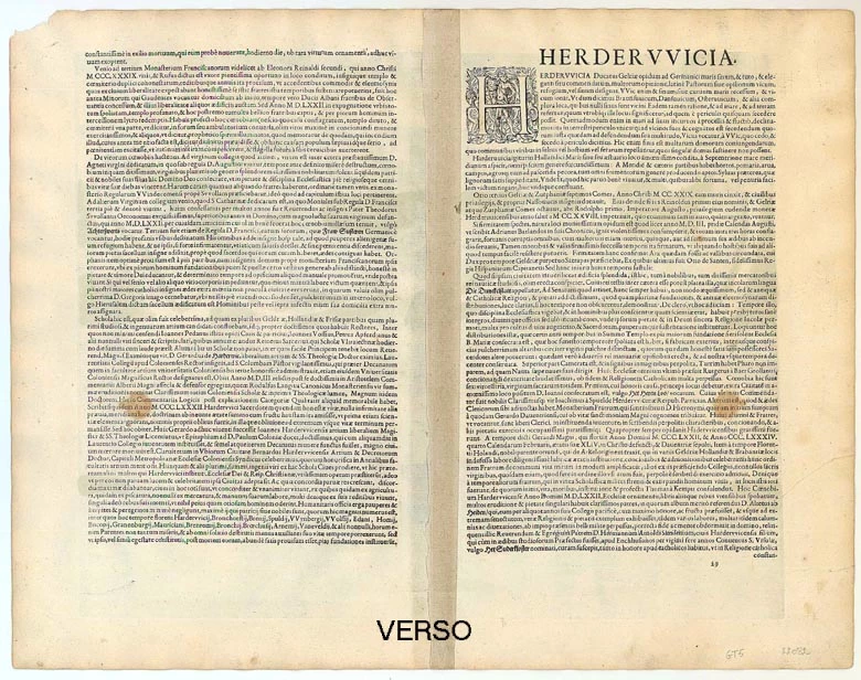
Verso text: Latin
Condition: Old coloured. Two brown stains in lower view, slight shine-through of verso text.
Condition Rating: B+
References: Van der Krogt 4, 1716; Fauser, 5465 & 5466; Taschen, Braun and Hogenberg, p.382.
From: Urbium Praeipuarum Mundi Theatrum Quintum Auctore Georgio Braunio Agrippinate. Part 5. Köln, Petrus von Brachel, 1623. (Van der Krogt 4, 41:1.5)
COMMENTARY BY BRAUN: "Harderwijk is a town in the Duchy of Guelders that lies on a curving bay and that is everywhere praised for its safe and attractive situation. If one looks south, one sees its rich fishing waters; looking north, there are woods and gardens, farmland suitable for cultivation and fertile fields. When one looks at the town itself, one is instantly struck by the magnificent buildings belonging both to nobles and to rich merchants. The church is dedicated to the Virgin, but in these difficult time it has thrice been plundered. It has a tower that also serves as a lighthouse, which sailors often use for orientation." The small port of Harderwijk on the Zuiderzee (today the IJsselmeer Lake) is reproduced in two magnificent complementary views. In the top illustration, the town is seen from a slightly elevated perspective from the southeastern mainland, while the bottom illustration shows the view from the Zuiderzee to the northwest, as if from an arriving ship. Particularly striking on the landward side are the massive fortified walls and bulwarks that surround the town, while its wide moat, which can be crossed only via drawbridges, makes it resemble an island. Harderwijk is first documented in 1231, when it was granted its municipal charter. In the 15th century the major fishing town and port joined the Hanseatic League. From this era dates the late Gothic Onze Lieve Vrouwe church, with its distinctive tower, which was renamed the Grote Kerk in 1578, in the wake of the Reformation. In 1584 Harderwijk, which enjoyed overland access to the Rhine via a cart track, was granted the right to mint its own regional coins. (Taschen)
Braun G. & Hogenberg F. and the Civitates Orbis Terrarum.
The Civitates Orbis Terrarum, also known as the 'Braun & Hogenberg', is a six-volume town atlas and the most excellent book of town views and plans ever published: 363 engravings, sometimes beautifully coloured. It was one of the best-selling works in the last quarter of the 16th century. Georg Braun, a skilled writer, wrote the text accompanying the plans and views on the verso. Many plates were engraved after the original drawings of a professional artist, Joris Hoefnagel (1542-1600). The first volume was published in Latin in 1572 and the sixth in 1617. Frans Hogenberg, a talented engraver, created the tables for volumes I through IV, and Simon van den Neuwel made those for volumes V and VI. Other contributors were cartographers Daniel Freese and Heinrich Rantzau, who provided valuable geographical information. Works by Jacob van Deventer, Sebastian Münster, and Johannes Stumpf were also used as references. Translations appeared in German and French, making the atlas accessible to a wider audience.
Since its original publication of volume 1 in 1572, the Civitates Orbis Terrarum has left an indelible mark on the history of cartography. The first volume was followed by seven more editions in 1575, 1577, 1582, 1588, 1593, 1599, and 1612. Vol.2, initially released in 1575, saw subsequent editions in 1597 and 1612. The subsequent volumes, each a treasure trove of historical insights, graced the world in 1581, 1588, 1593, 1599, and 1606. The German translation of the first volume, a testament to its widespread appeal, debuted in 1574, followed by the French edition in 1575.
Several printers were involved: Theodor Graminaeus, Heinrich von Aich, Gottfried von Kempen, Johannis Sinniger, Bertram Buchholtz, and Peter von Brachel, all of whom worked in Cologne.
Georg Braun (1541-1622)
Georg Braun, the author of the text accompanying the plans and views in the Civitates Orbis Terrarum, was born in Cologne in 1541. After his studies in Cologne, he entered the Jesuit Order as a novice, indicating his commitment to learning and intellectual pursuits. In 1561, he obtained his bachelor's degree; in 1562, he received his Magister Artium, further demonstrating his academic achievements. Although he left the Jesuit Order, he continued his studies in theology, gaining a licentiate in theology. His theological background likely influenced the content and tone of the text in the Civitates Orbis Terrarum, adding a unique perspective to the work.
Frans Hogenberg (1535-1590)
Frans Hogenberg was a Flemish and German painter, engraver, and mapmaker. He was born in Mechelen as the son of Nicolaas Hogenberg.
By the end of the 1560s, Frans Hogenberg was employed upon Abraham Ortelius's Theatrum Orbis Terrarum, published in 1570; he is named an engraver of numerous maps. In 1568, he was banned from Antwerp by the Duke of Alva and travelled to London, where he stayed a few years before emigrating to Cologne. He immediately embarked on his two most important works, the Civitates, published in 1572 and the Geschichtsblätter, which appeared in several series from 1569 until about 1587.
Thanks to large-scale projects like the Geschichtsblätter and the Civitates, Hogenberg's social circumstances improved with each passing year. He died as a wealthy man in Cologne in 1590.
Related items
Lewardum. Occidentalis Frisiae Opp: 1580. [on sheet with:] Franicher, Nobiliu hominum, in Frisia Occidentali, ut plurimum saedes. 1581-88
Leeuwarden & Franeker by Braun & Hogenberg.
[Item number: 20439]
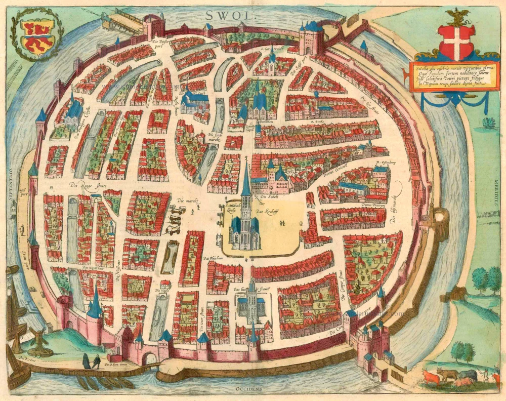
Swolla diu celebris meruit virtutibus Arma: ... 1599
Zwolle, by Georg Braun and Frans Hogenberg.
[Item number: 23318]