
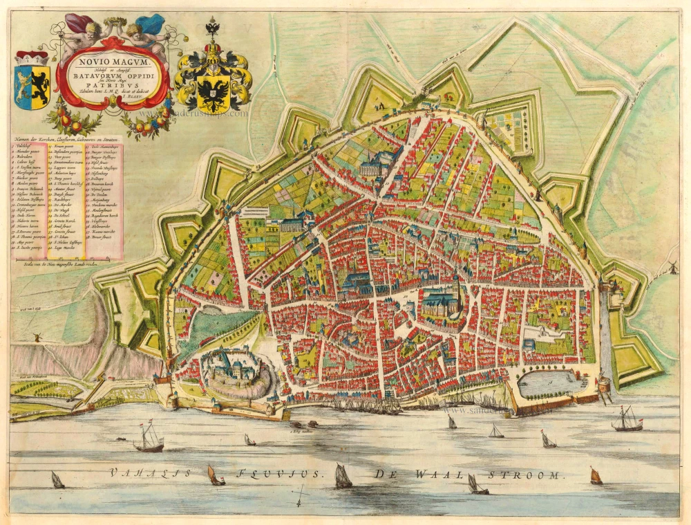
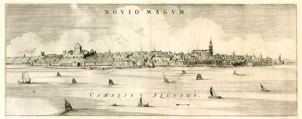
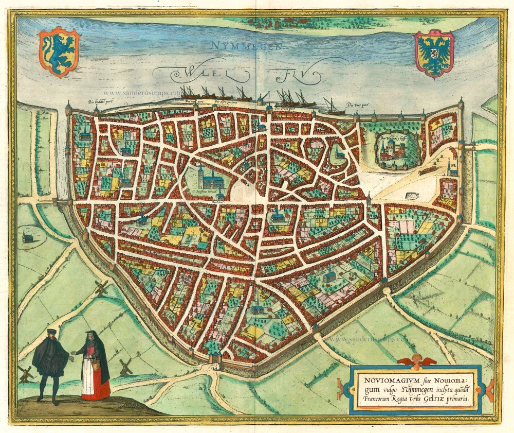
Nijmegen, by Blaeu J. 1649
The Blaeus: Willem Janszoon, Cornelis & Joan
Willem Jansz. Blaeu and his son Joan Blaeu are the seventeenth century's most widely known cartographic publishers.
Willem Jansz. (also written Guilielmus Janssonius) = Willem Janszoon Blaeu was born in Uitgeest (Netherlands), near Alkmaar, in 1571. He studied mathematics under Tycho Brahe and learned the theory and practice of astronomical observations and the art of instrument- and globe-making.
In 1596, he came to Amsterdam, where he settled down as a globe-, instrument- and mapmaker. He published his first cartographic work (a globe) in 1599 and probably published his first printed map (a map of the Netherlands) in 1604. He specialised in maritime cartography, published the first edition of the pilot guide Het Licht der Zeevaert in 1608, and was appointed Hydrographer of the V.O.C. (United East India Company) in 1633. After publishing books, wall maps, globes, charts and pilot guides for thirty years, he brought out his first atlas, Atlas Appendix (1630). This was the beginning of the great tradition of atlas-making by the Blaeus.
In 1618, another mapmaker, bookseller and publisher, Johannes Janssonius, established himself in Amsterdam next door to Blaeu's shop. No wonder these two neighbours began accusing each other of copying and stealing their information and became fierce competitors who did not have a good word to say about each other. In about 1621 Willem Jansz. decided to end the confusion between his name and his competitor's and assumed his grandfather's nickname, 'blauwe Willem' ('blue Willem'), as the family name; after that, he called himself Willem Jansz. Blaeu.
Willem Janszoon Blaeu died in 1638, leaving his prospering business to his sons, Cornelis and Joan. We only know that Cornelis's name occurs in the prefaces of books and atlases until c. 1645.
Joan Blaeu, born in Amsterdam in 1596, became a partner in his father's book trade and printing business. 1638, he was appointed his father's successor in the Hydrographic Office of the V.O.C. His efforts culminated in the magnificent Atlas Major and the town books of the Netherlands and Italy – works unsurpassed in history and modern times, giving eternal fame to the name of the Blaeu's.
A fire ruined the business on February 23, 1672, and one year later, Dr. Joan Blaeu died. The fire and the director's passing caused the complete sale of the Blaeu House's stock. Five public auctions dispersed the remaining books, atlases, copperplates, globes, etc., among many other map dealers and publishers in Amsterdam. The majority was acquired by several booksellers acting in partnership.
In the succeeding years, the remaining printing department remained in the hands of the Blaeu family until 1695, when the printing house's inventory was sold at a public auction. That meant the end of the Blaeu family as a printing house of world renown.
Novio Magum. Nobiliss et Ampliss. Batavorum Oppidi seu Novio Magi Patribus Tabulam hanc L.M.Q. dicat et dedicat I. Blaeu;
Item Number: 6257 Authenticity Guarantee
Category: Antique maps > Europe > The Netherlands - Cities
Antique map - Bird's-eye view plan of Nijmegen by J. Blaeu.
Date of the first edition: 1649
Date of this map: 1649
Copper engraving
Size: 42 x 55.5cm (16.4 x 21.6 inches)
Verso text: Latin
Condition: Old coloured, slightly waterstained.
Condition Rating: B+
References: Van der Krogt 4, 3069, State 1.
From: Novum Ac Magnum Theatrum Urbium Belgicae. (= "Stedeboeck") Amsterdam, J. Blaeu, 1649. (Koeman, Bl63)
The Blaeus: Willem Janszoon, Cornelis & Joan
Willem Jansz. Blaeu and his son Joan Blaeu are the seventeenth century's most widely known cartographic publishers.
Willem Jansz. (also written Guilielmus Janssonius) = Willem Janszoon Blaeu was born in Uitgeest (Netherlands), near Alkmaar, in 1571. He studied mathematics under Tycho Brahe and learned the theory and practice of astronomical observations and the art of instrument- and globe-making.
In 1596, he came to Amsterdam, where he settled down as a globe-, instrument- and mapmaker. He published his first cartographic work (a globe) in 1599 and probably published his first printed map (a map of the Netherlands) in 1604. He specialised in maritime cartography, published the first edition of the pilot guide Het Licht der Zeevaert in 1608, and was appointed Hydrographer of the V.O.C. (United East India Company) in 1633. After publishing books, wall maps, globes, charts and pilot guides for thirty years, he brought out his first atlas, Atlas Appendix (1630). This was the beginning of the great tradition of atlas-making by the Blaeus.
In 1618, another mapmaker, bookseller and publisher, Johannes Janssonius, established himself in Amsterdam next door to Blaeu's shop. No wonder these two neighbours began accusing each other of copying and stealing their information and became fierce competitors who did not have a good word to say about each other. In about 1621 Willem Jansz. decided to end the confusion between his name and his competitor's and assumed his grandfather's nickname, 'blauwe Willem' ('blue Willem'), as the family name; after that, he called himself Willem Jansz. Blaeu.
Willem Janszoon Blaeu died in 1638, leaving his prospering business to his sons, Cornelis and Joan. We only know that Cornelis's name occurs in the prefaces of books and atlases until c. 1645.
Joan Blaeu, born in Amsterdam in 1596, became a partner in his father's book trade and printing business. 1638, he was appointed his father's successor in the Hydrographic Office of the V.O.C. His efforts culminated in the magnificent Atlas Major and the town books of the Netherlands and Italy – works unsurpassed in history and modern times, giving eternal fame to the name of the Blaeu's.
A fire ruined the business on February 23, 1672, and one year later, Dr. Joan Blaeu died. The fire and the director's passing caused the complete sale of the Blaeu House's stock. Five public auctions dispersed the remaining books, atlases, copperplates, globes, etc., among many other map dealers and publishers in Amsterdam. The majority was acquired by several booksellers acting in partnership.
In the succeeding years, the remaining printing department remained in the hands of the Blaeu family until 1695, when the printing house's inventory was sold at a public auction. That meant the end of the Blaeu family as a printing house of world renown.
Related items
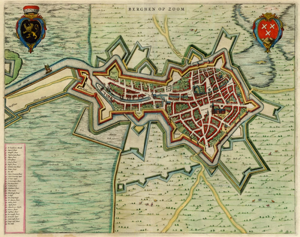
Berghen op Zoom 1649
Bergen-op-Zoom by Blaeu Joan.
[Item number: 657]
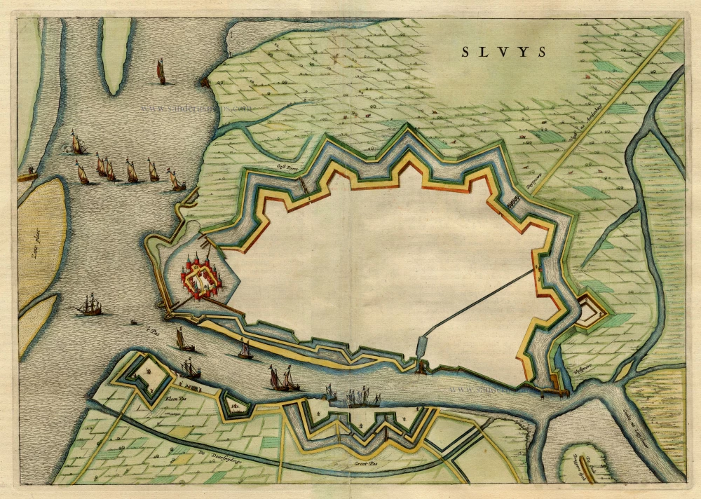
Sluys 1649
Sluis, by Blaeu J.
[Item number: 1928]
Noviomagum 1649
Nijmegen, by Joan Blaeu.
[Item number: 5605]
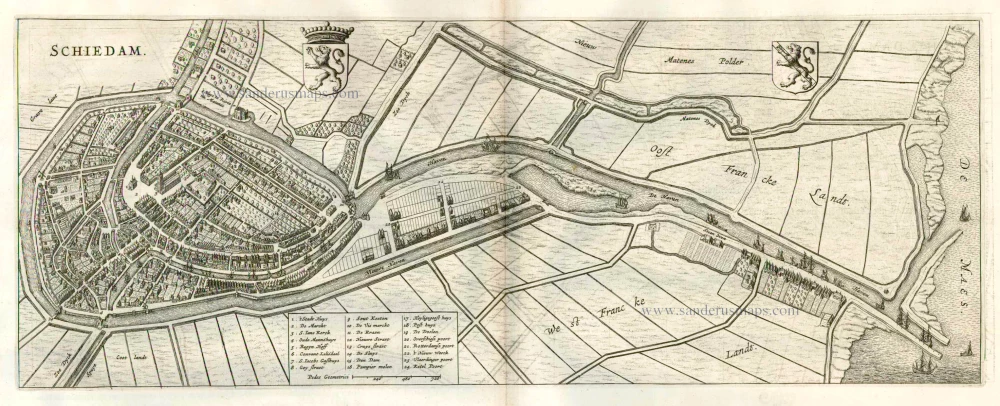
Schiedam 1649
Schiedam, by Joan Blaeu.
[Item number: 17065]
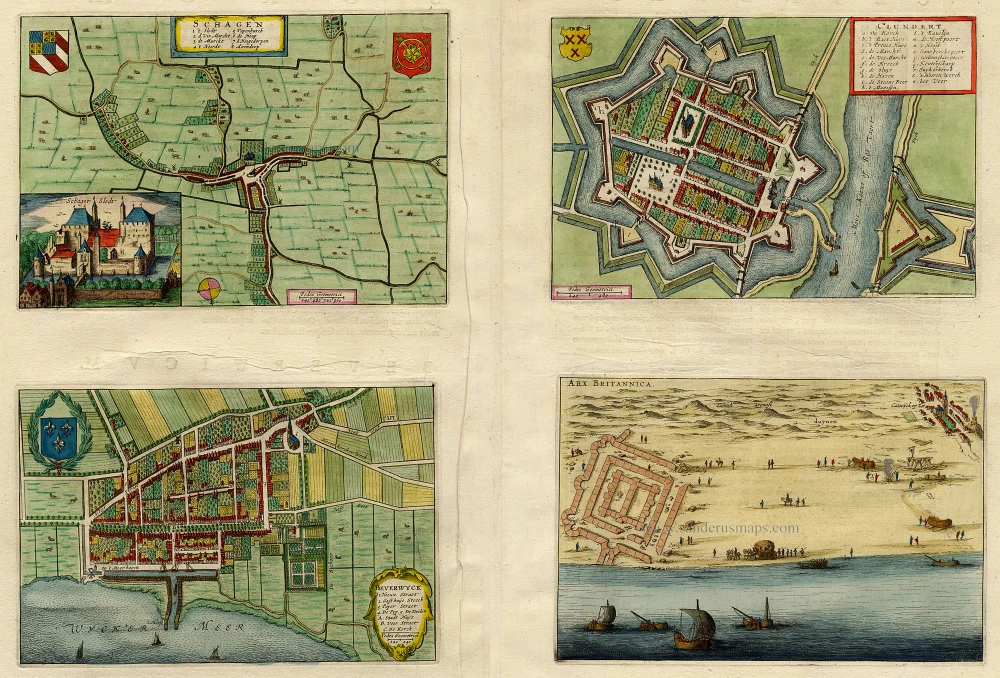
Schagen - Clundert - Beverwyck - Arx Britannica 1649
Schagen - Clundert - Beverwijk, by Blaeu J.
[Item number: 19568]
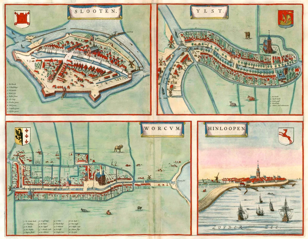
Slooten [on sheet with:] Ylst [and] Worcum [and] Hinloopen 1649
Sloten - IJlst - Workum - Hindeloopen, by Joan Blaeu.
[Item number: 23358]
Noviomagium. 1599
Nijmegen, by Georg Braun and Frans Hogenberg.
[Item number: 24033]
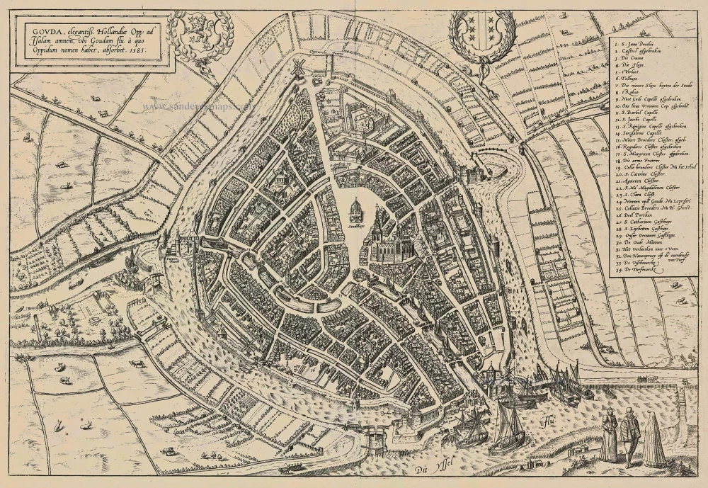
Gouda, elegantiss. Hollandiae Opp. ad Isalam amnem, ubi Goudam flu. à quo Oppidum nomen habet, absorbet. 1585. 1599
Gouda, by Georg Braun and Frans Hogenberg.
[Item number: 24088]

Tetrachia Ducatus Geldriae Neomagensis. c. 1689-90
Gelderland - Nijmegen by Frederick de Wit.
[Item number: 24431]
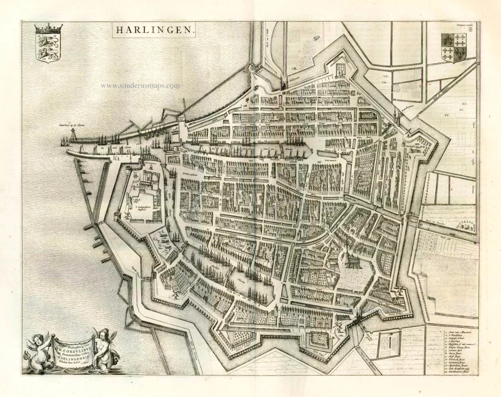
Harlingen. 1649
Harlingen, by Joan Blaeu.
[Item number: 25348]
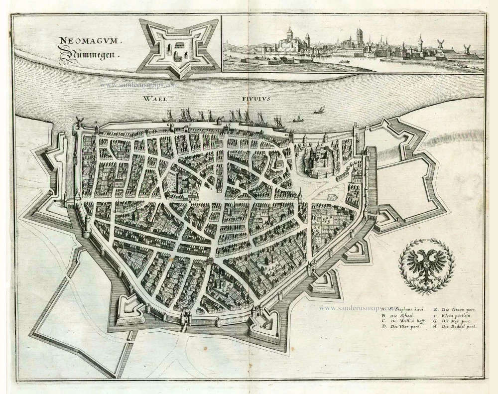
Neomagum. Nümmegen. 1638
Nijmegen, by M. Merian.
[Item number: 25891]
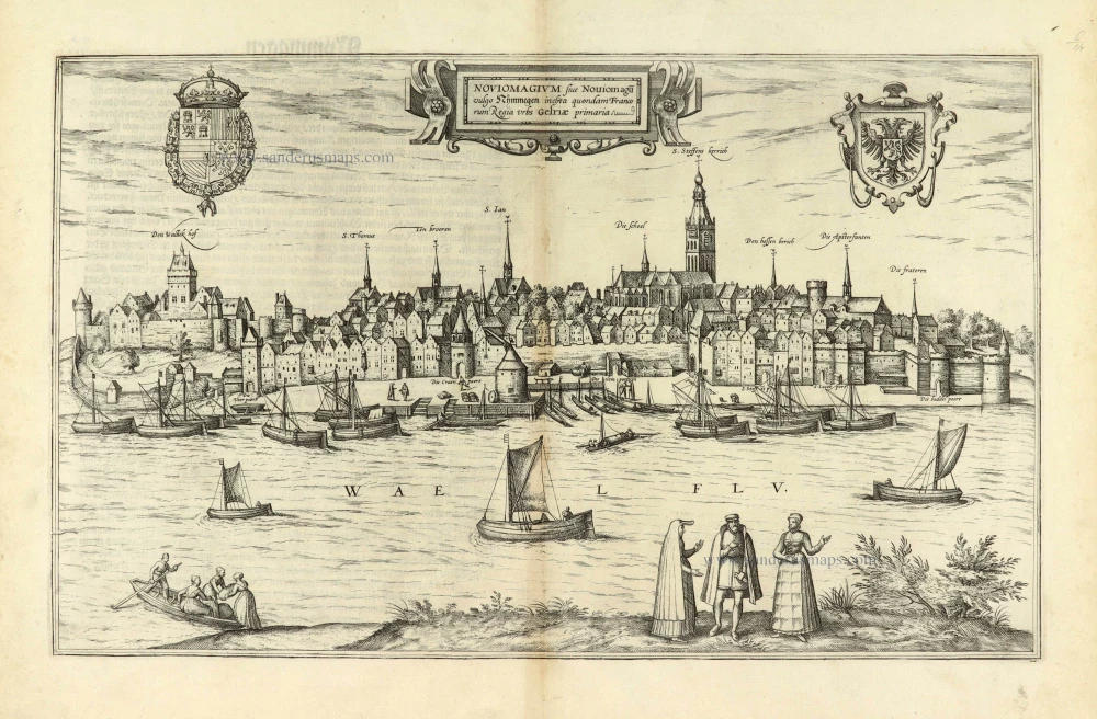
Noviomagium sive Noviomagu vulgo Nymmegen inclyta quondam Francorum Regia Urbs Gelriae primaria. 1576
Nijmegen, by Georg Braun & Frans Hogenberg.
[Item number: 28051]