
Dordrecht, by Georg Braun and Frans Hogenberg. 1597
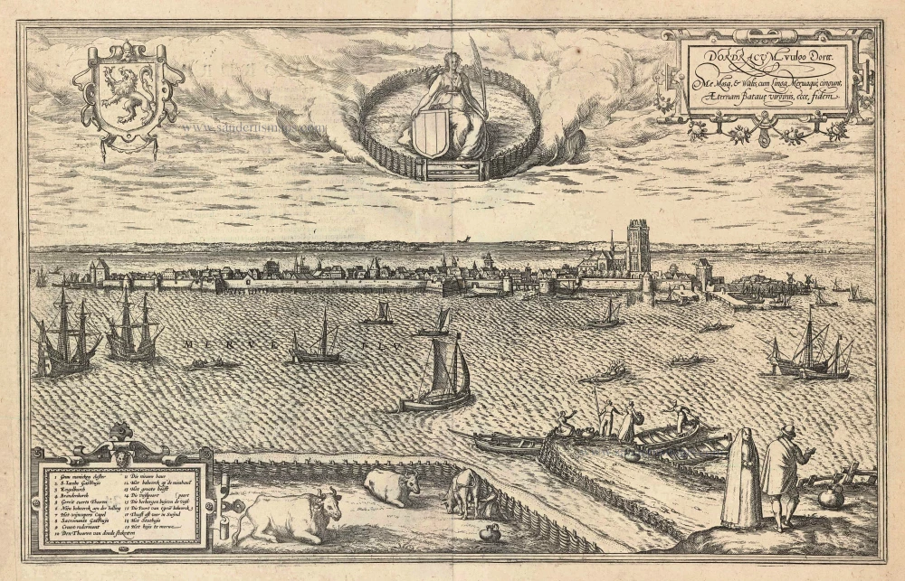
TRANSLATION OF CARTOUCHE TEXT: In Dordracum, in the vernacular Dordrecht, I am surrounded by Meuse, Waal, Lek and Merwede. Behold here the eternal faith in the Batavian Virgin.
COMMENTARY BY BRAUN: "Dordrecht is an old Dutch city situated on the Merwede, but as waters flow into this river from the Rhine, the Meuse and the Lek and it becomes one river, some claim that the city lies on four rivers. Due to these rivers its position is like an island. The Merwede affords great quantities of good fish, especially sturgeon and other choice fish."
Dordrecht is shown here as a view over the Merwede. The city is famed as Holland's oldest city, because it was granted a municipal charter as far as 1220 and was uncontested as the most important trade city and port of the province from the 13th to the 16th century. In November of 1421 a storm surge flooded Holland. Over 100,000 people died and the floods left an indelible mark on the area around Dordrecht. Behind Dordrecht the water did not flow away, thus the city became an island. The Grote Kerk, built in the Brabant-Gothic style, rises above the city. Another architectural jewel of the city is the Gothic town hall (18). In the building captioned Het groote hoof (13) a meeting took place in July 1572 of representatives of most of the Dutch towns, in order to declare William of Orange as their leader and their independence from Spain: this was the beginning of the Dutch Revolt. (Taschen)
Braun G. & Hogenberg F. and the Civitates Orbis Terrarum.
The Civitates Orbis Terrarum, also known as the 'Braun & Hogenberg', is a six-volume town atlas and the most excellent book of town views and plans ever published: 363 engravings, sometimes beautifully coloured. It was one of the best-selling works in the last quarter of the 16th century. Georg Braun, a skilled writer, wrote the text accompanying the plans and views on the verso. Many plates were engraved after the original drawings of a professional artist, Joris Hoefnagel (1542-1600). The first volume was published in Latin in 1572 and the sixth in 1617. Frans Hogenberg, a talented engraver, created the tables for volumes I through IV, and Simon van den Neuwel made those for volumes V and VI. Other contributors were cartographers Daniel Freese and Heinrich Rantzau, who provided valuable geographical information. Works by Jacob van Deventer, Sebastian Münster, and Johannes Stumpf were also used as references. Translations appeared in German and French, making the atlas accessible to a broader audience.
Since its original publication of volume 1 in 1572, the Civitates Orbis Terrarum has left an indelible mark on the history of cartography. Seven more editions followed the first volume in 1575, 1577, 1582, 1588, 1593, 1599, and 1612. Vol.2, initially released in 1575, saw subsequent editions in 1597 and 1612. The subsequent volumes, each a treasure trove of historical insights, graced the world in 1581, 1588, 1593, 1599, and 1606. The German translation of the first volume, a testament to its widespread appeal, debuted in 1574, followed by the French edition in 1575.
Several printers were involved: Theodor Graminaeus, Heinrich von Aich, Gottfried von Kempen, Johannis Sinniger, Bertram Buchholtz, and Peter von Brachel, all of whom worked in Cologne.
Georg Braun (1541-1622)
Georg Braun, the author of the text accompanying the plans and views in the Civitates Orbis Terrarum, was born in Cologne in 1541. After his studies in Cologne, he entered the Jesuit Order as a novice, indicating his commitment to learning and intellectual pursuits. In 1561, he obtained his bachelor's degree; in 1562, he received his Magister Artium, further demonstrating his academic achievements. Although he left the Jesuit Order, he continued his studies in theology, gaining a licentiate in theology. His theological background likely influenced the content and tone of the text in the Civitates Orbis Terrarum, adding a unique perspective to the work.
Frans Hogenberg (1535-1590)
Frans Hogenberg was a Flemish and German painter, engraver, and mapmaker. He was born in Mechelen as the son of Nicolaas Hogenberg.
By the end of the 1560s, Frans Hogenberg was employed upon Abraham Ortelius's Theatrum Orbis Terrarum, published in 1570; he is named an engraver of numerous maps. In 1568, he was banned from Antwerp by the Duke of Alva and travelled to London, where he stayed a few years before emigrating to Cologne. He immediately embarked on his two most important works, the Civitates, published in 1572 and the Geschichtsblätter, which appeared in several series from 1569 until about 1587.
Thanks to large-scale projects like the Geschichtsblätter and the Civitates, Hogenberg's social circumstances improved with each passing year. He died as a wealthy man in Cologne in 1590.
Dordracum vulgo Dortt
Item Number: 23978 Authenticity Guarantee
Category: Antique maps > Europe > The Netherlands - Cities
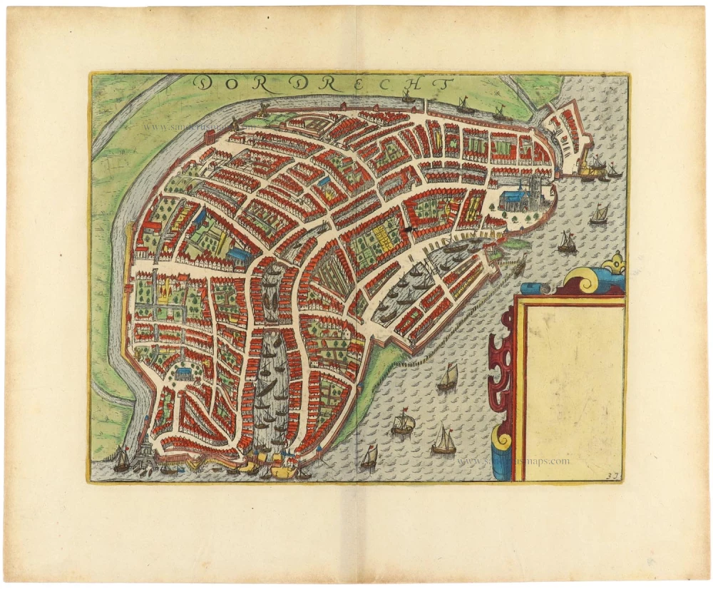
Antique map - view of Dordrecht by Braun and Hogenberg, with key to locations.
Date of the first edition: 1575
Date of this map: 1597
Copper engraving
Size: 31.5 x 49.5cm (12.2 x 19.3 inches)
Verso text: Latin
Condition: Uncoloured, excellent.
Condition Rating: A
References: Van der Krogt 4, 1113; Taschen, Braun and Hogenberg, p. 156.
From: Civitates Orbis Terrarum, ... Part 2: De Praecipuis, Totius Universi Urbibus, Liber Secundus. Köln, Bertram Buchholz, 1597. (Van der Krogt 4, 41:1.2)
TRANSLATION OF CARTOUCHE TEXT: In Dordracum, in the vernacular Dordrecht, I am surrounded by Meuse, Waal, Lek and Merwede. Behold here the eternal faith in the Batavian Virgin.
COMMENTARY BY BRAUN: "Dordrecht is an old Dutch city situated on the Merwede, but as waters flow into this river from the Rhine, the Meuse and the Lek and it becomes one river, some claim that the city lies on four rivers. Due to these rivers its position is like an island. The Merwede affords great quantities of good fish, especially sturgeon and other choice fish."
Dordrecht is shown here as a view over the Merwede. The city is famed as Holland's oldest city, because it was granted a municipal charter as far as 1220 and was uncontested as the most important trade city and port of the province from the 13th to the 16th century. In November of 1421 a storm surge flooded Holland. Over 100,000 people died and the floods left an indelible mark on the area around Dordrecht. Behind Dordrecht the water did not flow away, thus the city became an island. The Grote Kerk, built in the Brabant-Gothic style, rises above the city. Another architectural jewel of the city is the Gothic town hall (18). In the building captioned Het groote hoof (13) a meeting took place in July 1572 of representatives of most of the Dutch towns, in order to declare William of Orange as their leader and their independence from Spain: this was the beginning of the Dutch Revolt. (Taschen)
Braun G. & Hogenberg F. and the Civitates Orbis Terrarum.
The Civitates Orbis Terrarum, also known as the 'Braun & Hogenberg', is a six-volume town atlas and the most excellent book of town views and plans ever published: 363 engravings, sometimes beautifully coloured. It was one of the best-selling works in the last quarter of the 16th century. Georg Braun, a skilled writer, wrote the text accompanying the plans and views on the verso. Many plates were engraved after the original drawings of a professional artist, Joris Hoefnagel (1542-1600). The first volume was published in Latin in 1572 and the sixth in 1617. Frans Hogenberg, a talented engraver, created the tables for volumes I through IV, and Simon van den Neuwel made those for volumes V and VI. Other contributors were cartographers Daniel Freese and Heinrich Rantzau, who provided valuable geographical information. Works by Jacob van Deventer, Sebastian Münster, and Johannes Stumpf were also used as references. Translations appeared in German and French, making the atlas accessible to a broader audience.
Since its original publication of volume 1 in 1572, the Civitates Orbis Terrarum has left an indelible mark on the history of cartography. Seven more editions followed the first volume in 1575, 1577, 1582, 1588, 1593, 1599, and 1612. Vol.2, initially released in 1575, saw subsequent editions in 1597 and 1612. The subsequent volumes, each a treasure trove of historical insights, graced the world in 1581, 1588, 1593, 1599, and 1606. The German translation of the first volume, a testament to its widespread appeal, debuted in 1574, followed by the French edition in 1575.
Several printers were involved: Theodor Graminaeus, Heinrich von Aich, Gottfried von Kempen, Johannis Sinniger, Bertram Buchholtz, and Peter von Brachel, all of whom worked in Cologne.
Georg Braun (1541-1622)
Georg Braun, the author of the text accompanying the plans and views in the Civitates Orbis Terrarum, was born in Cologne in 1541. After his studies in Cologne, he entered the Jesuit Order as a novice, indicating his commitment to learning and intellectual pursuits. In 1561, he obtained his bachelor's degree; in 1562, he received his Magister Artium, further demonstrating his academic achievements. Although he left the Jesuit Order, he continued his studies in theology, gaining a licentiate in theology. His theological background likely influenced the content and tone of the text in the Civitates Orbis Terrarum, adding a unique perspective to the work.
Frans Hogenberg (1535-1590)
Frans Hogenberg was a Flemish and German painter, engraver, and mapmaker. He was born in Mechelen as the son of Nicolaas Hogenberg.
By the end of the 1560s, Frans Hogenberg was employed upon Abraham Ortelius's Theatrum Orbis Terrarum, published in 1570; he is named an engraver of numerous maps. In 1568, he was banned from Antwerp by the Duke of Alva and travelled to London, where he stayed a few years before emigrating to Cologne. He immediately embarked on his two most important works, the Civitates, published in 1572 and the Geschichtsblätter, which appeared in several series from 1569 until about 1587.
Thanks to large-scale projects like the Geschichtsblätter and the Civitates, Hogenberg's social circumstances improved with each passing year. He died as a wealthy man in Cologne in 1590.
Related items
Dordrecht. 1609
Dordrecht by Lodovico Guicciardini.
[Item number: 18456]

Lewardum. Occidentalis Frisiae Opp: 1580. [on sheet with:] Franicher, Nobiliu hominum, in Frisia Occidentali, ut plurimum saedes. 1581-88
Leeuwarden & Franeker by Braun & Hogenberg.
[Item number: 20439]

Arnhemium (on sheet with) Venlonum (and) Gelria (and) Ruremunda. 1581-88
Arnhem, Venlo, Gelre and Roermond, by Georg Braun and Frans Hogenberg.
[Item number: 21605]

Dordrecht. 1612
Dordrecht by Lodovico Guicciardini.
[Item number: 33053]