Bergen, by Georg Braun & Frans Hogenberg. (Norway) 1588
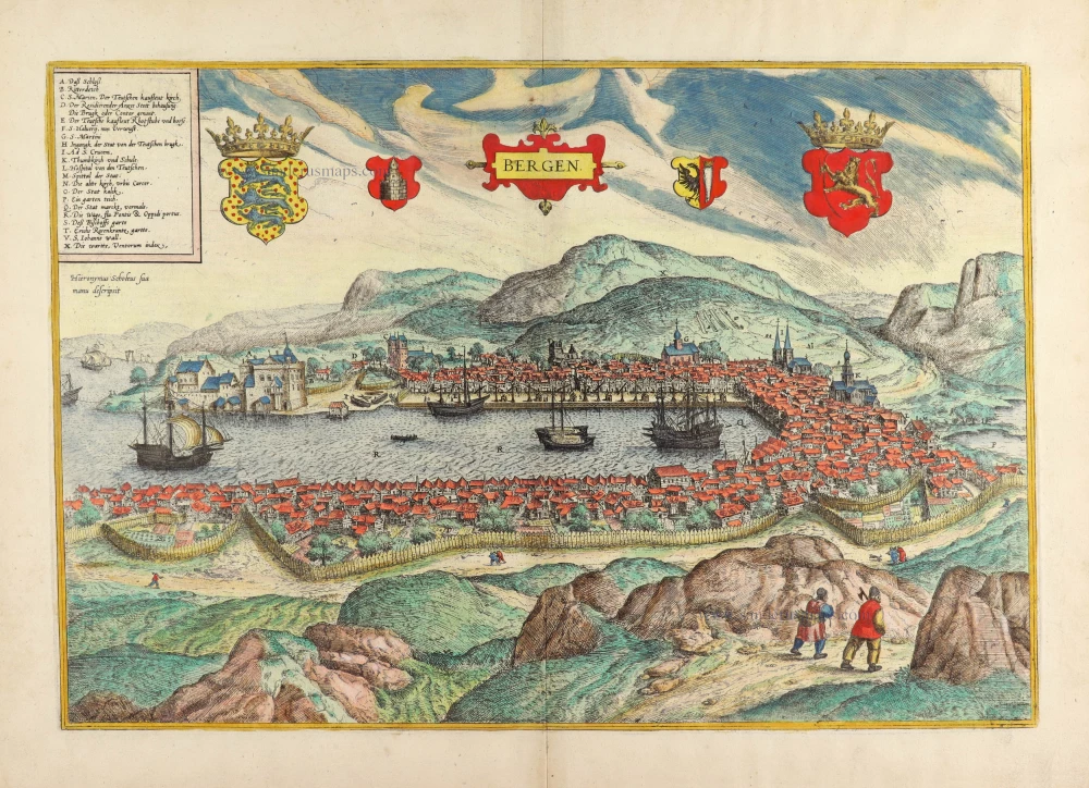


COMMENTARY BY BRAUN (on verso): "Most of the finest buildings in the city, be they houses of worship or domiciles, belong to the Hanseatic merchants, the Osterlingen, as they are called there. The rest are shoddily made, with walls of timber pieced together and roofed over with green moss. Nevertheless, the German merchants have a splendid outpost in Bergen because it is excellently suited for trade and commerce, for it encompasses a whole side of the harbour [...]. They have separate trading posts corresponding to the diversity of their cities and countries of origin. Hence, the merchants from Lübeck, Danzig, Cologne, Brunswick and Hamburg each have a site by the shore, on which they unload the ships from their cities, load them again, and send them back to Germany."
Bergen, founded in 1070 and fortified with a palisade, is seen from the southwest across Vägen Bay, which opens onto Byfjord. From the dense commotion of timber houses soars St Mary's, the Gothic cathedral attended by the German merchants (C), and the fortress of Bergenhus (A), the 13th-century seat of the Norwegian kings. The harbour is dominated by the Tyska Bryggen (German Quay), the quarter with the old mercantile houses and the sprawling quay; the numerous cranes and the ships allude to the flourishing trade conducted by the fourth-largest entrepôt in the Hanseatic League. The wealth of what was then the largest city in Scandinavia, which, with an impassable hinterland, could be reached only by sea, came from its far-flung trade in salt fish. Even after the Hansa disbanded in the 17th cent., Bergen retained its importance. (Taschen)
Braun G. & Hogenberg F. and the Civitates Orbis Terrarum.
The Civitates Orbis Terrarum, also known as the 'Braun & Hogenberg', is a six-volume town atlas and the most excellent book of town views and plans ever published: 363 engravings, sometimes beautifully coloured. It was one of the best-selling works in the last quarter of the 16th century. Georg Braun, a skilled writer, wrote the text accompanying the plans and views on the verso. Many plates were engraved after the original drawings of a professional artist, Joris Hoefnagel (1542-1600). The first volume was published in Latin in 1572 and the sixth in 1617. Frans Hogenberg, a talented engraver, created the tables for volumes I through IV, and Simon van den Neuwel made those for volumes V and VI. Other contributors were cartographers Daniel Freese and Heinrich Rantzau, who provided valuable geographical information. Works by Jacob van Deventer, Sebastian Münster, and Johannes Stumpf were also used as references. Translations appeared in German and French, making the atlas accessible to a wider audience.
Since its original publication of volume 1 in 1572, the Civitates Orbis Terrarum has left an indelible mark on the history of cartography. The first volume was followed by seven more editions in 1575, 1577, 1582, 1588, 1593, 1599, and 1612. Vol.2, initially released in 1575, saw subsequent editions in 1597 and 1612. The subsequent volumes, each a treasure trove of historical insights, graced the world in 1581, 1588, 1593, 1599, and 1606. The German translation of the first volume, a testament to its widespread appeal, debuted in 1574, followed by the French edition in 1575.
Several printers were involved: Theodor Graminaeus, Heinrich von Aich, Gottfried von Kempen, Johannis Sinniger, Bertram Buchholtz, and Peter von Brachel, all of whom worked in Cologne.
Georg Braun (1541-1622)
Georg Braun, the author of the text accompanying the plans and views in the Civitates Orbis Terrarum, was born in Cologne in 1541. After his studies in Cologne, he entered the Jesuit Order as a novice, indicating his commitment to learning and intellectual pursuits. In 1561, he obtained his bachelor's degree; in 1562, he received his Magister Artium, further demonstrating his academic achievements. Although he left the Jesuit Order, he continued his studies in theology, gaining a licentiate in theology. His theological background likely influenced the content and tone of the text in the Civitates Orbis Terrarum, adding a unique perspective to the work.
Frans Hogenberg (1535-1590)
Frans Hogenberg was a Flemish and German painter, engraver, and mapmaker. He was born in Mechelen as the son of Nicolaas Hogenberg.
By the end of the 1560s, Frans Hogenberg was employed upon Abraham Ortelius's Theatrum Orbis Terrarum, published in 1570; he is named an engraver of numerous maps. In 1568, he was banned from Antwerp by the Duke of Alva and travelled to London, where he stayed a few years before emigrating to Cologne. He immediately embarked on his two most important works, the Civitates, published in 1572 and the Geschichtsblätter, which appeared in several series from 1569 until about 1587.
Thanks to large-scale projects like the Geschichtsblätter and the Civitates, Hogenberg's social circumstances improved with each passing year. He died as a wealthy man in Cologne in 1590.
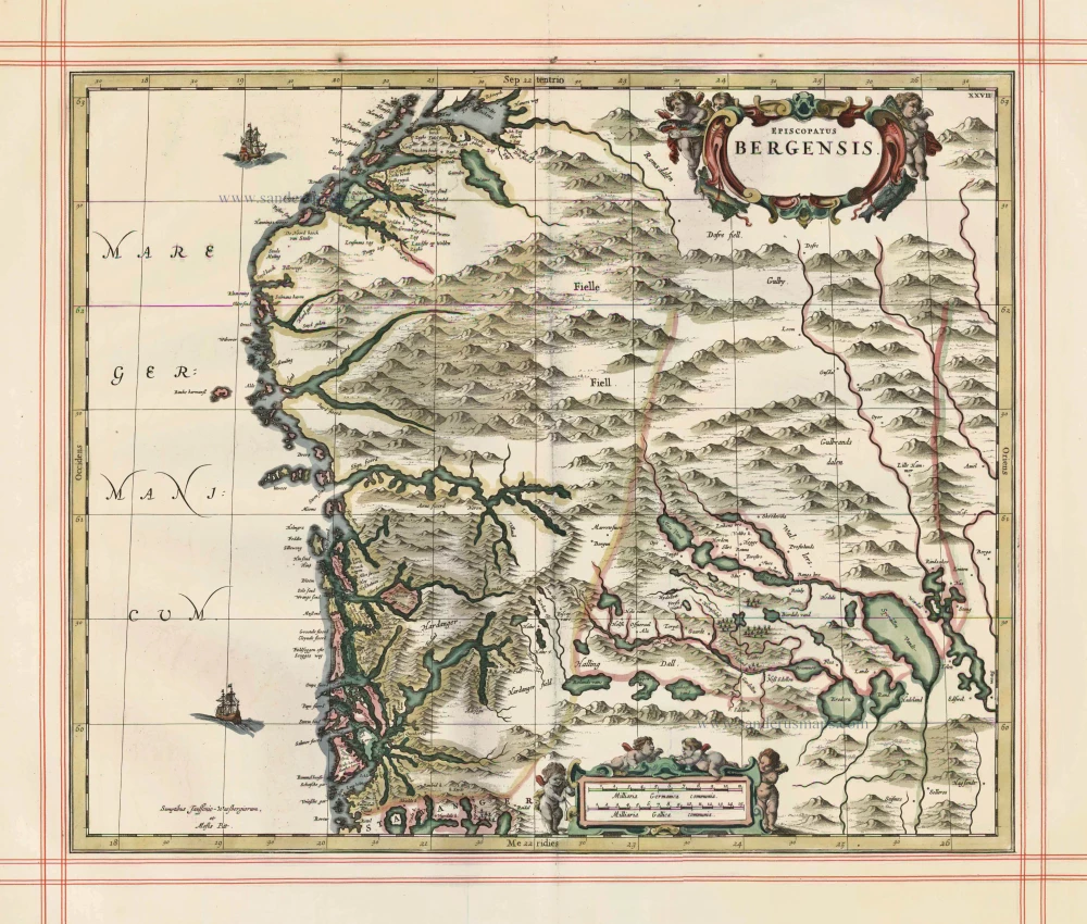
Bergen.
Item Number: 30616 new Authenticity Guarantee
Category: Antique maps > Europe > Northern Europe
Bird's-eye view of Bergen (Norway), by Georg Braun & Frans Hogenberg.
Title: Bergen.
Hieronymus Scholeus sua manu descripsit.
Cartographer: Hieronymus Scholeus.
Date of the first edition: 1588.
Date of this map: 1588.
Copper engraving, printed on paper.
Image size: 325 x 475mm (12.8 x 18.7 inches).
Sheet size: 415 x 535mm (16.34 x 21.06 inches).
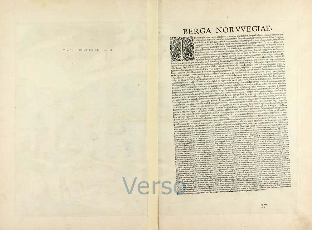
Verso: Latin text.
Condition: Original coloured, excellent.
Condition Rating: A+.
From: Liber Quartus Urbium Praecipuarum Totius Mundi. Cologne, 1588. (Koeman, B&H4, Van der Krogt 4, 41:1.4)
COMMENTARY BY BRAUN (on verso): "Most of the finest buildings in the city, be they houses of worship or domiciles, belong to the Hanseatic merchants, the Osterlingen, as they are called there. The rest are shoddily made, with walls of timber pieced together and roofed over with green moss. Nevertheless, the German merchants have a splendid outpost in Bergen because it is excellently suited for trade and commerce, for it encompasses a whole side of the harbour [...]. They have separate trading posts corresponding to the diversity of their cities and countries of origin. Hence, the merchants from Lübeck, Danzig, Cologne, Brunswick and Hamburg each have a site by the shore, on which they unload the ships from their cities, load them again, and send them back to Germany."
Bergen, founded in 1070 and fortified with a palisade, is seen from the southwest across Vägen Bay, which opens onto Byfjord. From the dense commotion of timber houses soars St Mary's, the Gothic cathedral attended by the German merchants (C), and the fortress of Bergenhus (A), the 13th-century seat of the Norwegian kings. The harbour is dominated by the Tyska Bryggen (German Quay), the quarter with the old mercantile houses and the sprawling quay; the numerous cranes and the ships allude to the flourishing trade conducted by the fourth-largest entrepôt in the Hanseatic League. The wealth of what was then the largest city in Scandinavia, which, with an impassable hinterland, could be reached only by sea, came from its far-flung trade in salt fish. Even after the Hansa disbanded in the 17th cent., Bergen retained its importance. (Taschen)
Braun G. & Hogenberg F. and the Civitates Orbis Terrarum.
The Civitates Orbis Terrarum, also known as the 'Braun & Hogenberg', is a six-volume town atlas and the most excellent book of town views and plans ever published: 363 engravings, sometimes beautifully coloured. It was one of the best-selling works in the last quarter of the 16th century. Georg Braun, a skilled writer, wrote the text accompanying the plans and views on the verso. Many plates were engraved after the original drawings of a professional artist, Joris Hoefnagel (1542-1600). The first volume was published in Latin in 1572 and the sixth in 1617. Frans Hogenberg, a talented engraver, created the tables for volumes I through IV, and Simon van den Neuwel made those for volumes V and VI. Other contributors were cartographers Daniel Freese and Heinrich Rantzau, who provided valuable geographical information. Works by Jacob van Deventer, Sebastian Münster, and Johannes Stumpf were also used as references. Translations appeared in German and French, making the atlas accessible to a wider audience.
Since its original publication of volume 1 in 1572, the Civitates Orbis Terrarum has left an indelible mark on the history of cartography. The first volume was followed by seven more editions in 1575, 1577, 1582, 1588, 1593, 1599, and 1612. Vol.2, initially released in 1575, saw subsequent editions in 1597 and 1612. The subsequent volumes, each a treasure trove of historical insights, graced the world in 1581, 1588, 1593, 1599, and 1606. The German translation of the first volume, a testament to its widespread appeal, debuted in 1574, followed by the French edition in 1575.
Several printers were involved: Theodor Graminaeus, Heinrich von Aich, Gottfried von Kempen, Johannis Sinniger, Bertram Buchholtz, and Peter von Brachel, all of whom worked in Cologne.
Georg Braun (1541-1622)
Georg Braun, the author of the text accompanying the plans and views in the Civitates Orbis Terrarum, was born in Cologne in 1541. After his studies in Cologne, he entered the Jesuit Order as a novice, indicating his commitment to learning and intellectual pursuits. In 1561, he obtained his bachelor's degree; in 1562, he received his Magister Artium, further demonstrating his academic achievements. Although he left the Jesuit Order, he continued his studies in theology, gaining a licentiate in theology. His theological background likely influenced the content and tone of the text in the Civitates Orbis Terrarum, adding a unique perspective to the work.
Frans Hogenberg (1535-1590)
Frans Hogenberg was a Flemish and German painter, engraver, and mapmaker. He was born in Mechelen as the son of Nicolaas Hogenberg.
By the end of the 1560s, Frans Hogenberg was employed upon Abraham Ortelius's Theatrum Orbis Terrarum, published in 1570; he is named an engraver of numerous maps. In 1568, he was banned from Antwerp by the Duke of Alva and travelled to London, where he stayed a few years before emigrating to Cologne. He immediately embarked on his two most important works, the Civitates, published in 1572 and the Geschichtsblätter, which appeared in several series from 1569 until about 1587.
Thanks to large-scale projects like the Geschichtsblätter and the Civitates, Hogenberg's social circumstances improved with each passing year. He died as a wealthy man in Cologne in 1590.