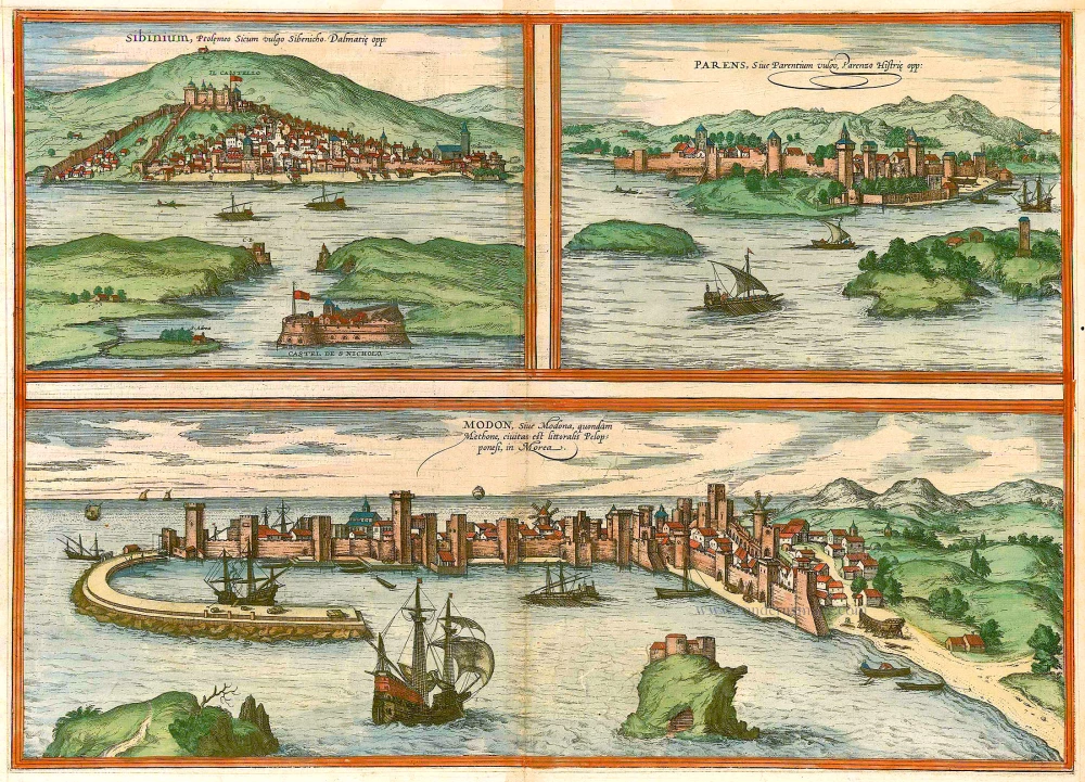
Antique map of Sibernik, Porec and Modon by Braun & Hogenberg 1575
Braun G. & Hogenberg F. and the Civitates Orbis Terrarum.
The Civitates Orbis Terrarum, also known as the 'Braun & Hogenberg', is a six-volume town atlas and the most excellent book of town views and plans ever published: 363 engravings, sometimes beautifully coloured. It was one of the best-selling works in the last quarter of the 16th century. Georg Braun, a skilled writer, wrote the text accompanying the plans and views on the verso. Many plates were engraved after the original drawings of a professional artist, Joris Hoefnagel (1542-1600). The first volume was published in Latin in 1572 and the sixth in 1617. Frans Hogenberg, a talented engraver, created the tables for volumes I through IV, and Simon van den Neuwel made those for volumes V and VI. Other contributors were cartographers Daniel Freese and Heinrich Rantzau, who provided valuable geographical information. Works by Jacob van Deventer, Sebastian Münster, and Johannes Stumpf were also used as references. Translations appeared in German and French, making the atlas accessible to a broader audience.
Since its original publication of volume 1 in 1572, the Civitates Orbis Terrarum has left an indelible mark on the history of cartography. Seven more editions followed the first volume in 1575, 1577, 1582, 1588, 1593, 1599, and 1612. Vol.2, initially released in 1575, saw subsequent editions in 1597 and 1612. The subsequent volumes, each a treasure trove of historical insights, graced the world in 1581, 1588, 1593, 1599, and 1606. The German translation of the first volume, a testament to its widespread appeal, debuted in 1574, followed by the French edition in 1575.
Several printers were involved: Theodor Graminaeus, Heinrich von Aich, Gottfried von Kempen, Johannis Sinniger, Bertram Buchholtz, and Peter von Brachel, all of whom worked in Cologne.
Georg Braun (1541-1622)
Georg Braun, the author of the text accompanying the plans and views in the Civitates Orbis Terrarum, was born in Cologne in 1541. After his studies in Cologne, he entered the Jesuit Order as a novice, indicating his commitment to learning and intellectual pursuits. In 1561, he obtained his bachelor's degree; in 1562, he received his Magister Artium, further demonstrating his academic achievements. Although he left the Jesuit Order, he continued his studies in theology, gaining a licentiate in theology. His theological background likely influenced the content and tone of the text in the Civitates Orbis Terrarum, adding a unique perspective to the work.
Frans Hogenberg (1535-1590)
Frans Hogenberg was a Flemish and German painter, engraver, and mapmaker. He was born in Mechelen as the son of Nicolaas Hogenberg.
By the end of the 1560s, Frans Hogenberg was employed upon Abraham Ortelius's Theatrum Orbis Terrarum, published in 1570; he is named an engraver of numerous maps. In 1568, he was banned from Antwerp by the Duke of Alva and travelled to London, where he stayed a few years before emigrating to Cologne. He immediately embarked on his two most important works, the Civitates, published in 1572 and the Geschichtsblätter, which appeared in several series from 1569 until about 1587.
Thanks to large-scale projects like the Geschichtsblätter and the Civitates, Hogenberg's social circumstances improved with each passing year. He died as a wealthy man in Cologne in 1590.
Sibinium, Ptolemeo Sicum vulgo Sibenicho. Dalmatie Opp. [on sheet with] Parens, sive Parentium vulgo, Parenzo Histriae Opp. [and] Modon, sive Modona, quondam Methone, Civitas est Littoralis Pelopponesi, in Morea
Item Number: 21640 Authenticity Guarantee
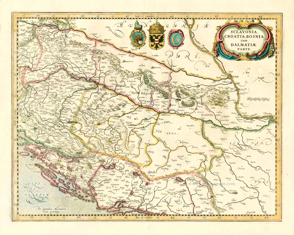
Category: Antique maps > Europe > Southeastern Europe
Antique map with three bird's eye views by Braun and Hogenberg: Sibenik, Porec and Methoni.
SIBENIK
CAPTION: Sibinium, for Ptolemy Sicum, commonly Sebenico, Dalmatian town.
COMMENTARY BY BRAUN: "Sibenik, which is called Sicum by the elderly and Sebenicho in their accustomed tongue, lies on the Adriatic Sea on the edge of Dalmatia and falls under the domain of the Venetians. Pliny says that Emperor Claudius provided for his old soldiers in this town."
Sibenik is depicted from the sea, overlooking the narrow harbour entrance to the sound with its St Nicolas's fort and two bastions. St Michael's (today St Anne's) fortress can be seen on the hill above the town. Sibenik was first mentioned in 1066. After multiple, alternating rulers in 1412 Sibenik was captured by the Venetians and remained under their rule until 1797. The three-nave cathedral, one of the most famous Dalmatian Renaissance structures, which was erected from 1431 to 1535 in honour of St James, can be made out with its characteristic domed crossing at the front centre; to the right is the church of St Francis. Sibenik lies on the Adriatic coast in Dalmatia, a region steeped in history, and today has 52,000 inhabitants.
POREC
CAPTION: Parens or Parentium, commonly Porec, a town in Istria.
COMMENTARY BY BRAUN: "Porec is a town in Dalmatia on the Adriatic Sea. Bernhard von Breydenbach writes about it in his Reise nach Jerusalem: As Paris wanted to abduct Helena, he had his ships fortified in this city. [...] From this town one can easily travel to Jerusalem, but obtaining a passport presents many difficulties since Dalmatians and Istrians have different rulers. [...] And since no one is allowed to tour this countryside, topographers and geographers have also produced little on it."
Porec is depicted from the sea as a well-fortified town with towers and solid walls, in the foreground is St Nicholas's Island with a Benedictine monastery. Behind the high walls, in the Euphrasius basilica from the 6th century, is identifiable on the left, and, on the right, the church of St Mary. The town was founded in c. 100 BC, after the Roman conquest of the resident Histri. Following the migration period Porec was under Byzantine rule for some 250 years, and, after alternating and unclear governance, the Venetians rose to power in 1267. Porec is today a major port on the west coast of Istria, with 17,000 residents.
METHONI
CAPTION: Modon or Modona, also Methoni, is a coastal town of the Peloponnese in the countryside of Morea
COMMENTARY BY BRAUN: "The Turkish Sultan Bayezid II laid lengthy siege to Methoni; storming it simultaneously at three points. [...] As the town was now in great danger and there was little hope of holding out for long, four Venetian galleys came suddenly to the town's rescue, well outfitted with soldiers, provisions, munitions and weapons. Now, as every man ran excitedly from the town to the harbour to joyously welcome the reinforcements, all entrenchments and firing positions were abandoned by the soldiers. Meanwhile, all the Janizaries recognized the favourable opportunity and scaled the empty city walls, thus capturing the town on St Lawrence Day, 10 August 1500."
The plate is depicted from the sea and affords a direct view into the harbour of the well-fortified town. Methoni was referred to as Pedasus in Homer's Iliad and was undefeated in antiquity due to its natural harbour. At the beginning of the 2nd century AD, Emperor Trajan declared the town independent. In 395 it belonged to the Byzantine Empire. In 1124 Methoni was captured by the Venetians; in 1498 it was besieged by the Ottomans under Sultan Bayezid II and finally captured on 9 (not 10) August 1500.
The three views are made after woodcuts by Erhard Reuwich in Bernard von Breydenbach's Peregrinatio in terram sanctam, 1486. (Taschen)
Date of the first edition: 1575
Date of this map: 1575
Copper engraving
Size: 35 x 49.5cm (13.7 x 19.2 inches)
Verso text: Latin
Condition: Old coloured, excellent.
Condition Rating: A
References: Van der Krogt 4, 3985; Taschen, Braun and Hogenberg, p.187.
From: Civitates Orbis Terrarum, ... Part 2: De Praecipuis, Totius Universi Urbibus, Liber Secundus. Köln, Gottfried von Kempen, 1575. (Van der Krogt 4, 41:1.2)
Braun G. & Hogenberg F. and the Civitates Orbis Terrarum.
The Civitates Orbis Terrarum, also known as the 'Braun & Hogenberg', is a six-volume town atlas and the most excellent book of town views and plans ever published: 363 engravings, sometimes beautifully coloured. It was one of the best-selling works in the last quarter of the 16th century. Georg Braun, a skilled writer, wrote the text accompanying the plans and views on the verso. Many plates were engraved after the original drawings of a professional artist, Joris Hoefnagel (1542-1600). The first volume was published in Latin in 1572 and the sixth in 1617. Frans Hogenberg, a talented engraver, created the tables for volumes I through IV, and Simon van den Neuwel made those for volumes V and VI. Other contributors were cartographers Daniel Freese and Heinrich Rantzau, who provided valuable geographical information. Works by Jacob van Deventer, Sebastian Münster, and Johannes Stumpf were also used as references. Translations appeared in German and French, making the atlas accessible to a broader audience.
Since its original publication of volume 1 in 1572, the Civitates Orbis Terrarum has left an indelible mark on the history of cartography. Seven more editions followed the first volume in 1575, 1577, 1582, 1588, 1593, 1599, and 1612. Vol.2, initially released in 1575, saw subsequent editions in 1597 and 1612. The subsequent volumes, each a treasure trove of historical insights, graced the world in 1581, 1588, 1593, 1599, and 1606. The German translation of the first volume, a testament to its widespread appeal, debuted in 1574, followed by the French edition in 1575.
Several printers were involved: Theodor Graminaeus, Heinrich von Aich, Gottfried von Kempen, Johannis Sinniger, Bertram Buchholtz, and Peter von Brachel, all of whom worked in Cologne.
Georg Braun (1541-1622)
Georg Braun, the author of the text accompanying the plans and views in the Civitates Orbis Terrarum, was born in Cologne in 1541. After his studies in Cologne, he entered the Jesuit Order as a novice, indicating his commitment to learning and intellectual pursuits. In 1561, he obtained his bachelor's degree; in 1562, he received his Magister Artium, further demonstrating his academic achievements. Although he left the Jesuit Order, he continued his studies in theology, gaining a licentiate in theology. His theological background likely influenced the content and tone of the text in the Civitates Orbis Terrarum, adding a unique perspective to the work.
Frans Hogenberg (1535-1590)
Frans Hogenberg was a Flemish and German painter, engraver, and mapmaker. He was born in Mechelen as the son of Nicolaas Hogenberg.
By the end of the 1560s, Frans Hogenberg was employed upon Abraham Ortelius's Theatrum Orbis Terrarum, published in 1570; he is named an engraver of numerous maps. In 1568, he was banned from Antwerp by the Duke of Alva and travelled to London, where he stayed a few years before emigrating to Cologne. He immediately embarked on his two most important works, the Civitates, published in 1572 and the Geschichtsblätter, which appeared in several series from 1569 until about 1587.
Thanks to large-scale projects like the Geschichtsblätter and the Civitates, Hogenberg's social circumstances improved with each passing year. He died as a wealthy man in Cologne in 1590.