
Kostajnica (Croatia) by Georg Braun & Frans Hogenberg. c. 1625
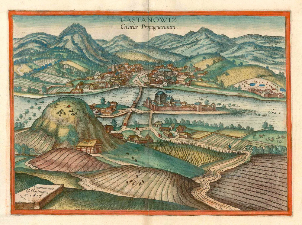


CAPTION: Kostajnica, a fortress in Croatia
COMMENTARY BY BRAUN (on verso): "After the Turks had held Kostajnica for two years and longer, it was recaptured in 1594 together with the area around Petrinja by the governor of Croatia, Mr Lenckowitz, captain-general under Archduke Maximilian. [...] And the Pasha of Bosnia immediately gathered a stronger army to attack and destroy the fortress and the camp of the Christians. [...] One cannot hope enough that the Christians will bury all hatred, discord and enmity among themselves so that they may tear as many lovely kingdoms, lands and cities as possible from the jaws of this barbaric enemy and, above all, deliver many thousands of souls from oppression."
This is a view from the south of the village with its watchtower and church, setting an idyllic rural wine-growing area. The village lies on the north bank of the Una, on either side of the road that crosses the river. Crescent flags are flying over the fortress on the far right and over the castle on the island built by the Croatian noble family of the Frankopans, showing that we are in an Ottoman-occupied area. The episode referred to by Braun was one of the many conflicts in the border area. Kostajnica (German Castanowitz) was in the hands of the Turks from 1556 to 1687. Today, this little town lies on the border with Bosnia and is called Hrvatska Kostajnica, to distinguish it from Bosanka Kostajnica, south of Bosnia's river. (Taschen)
Braun G. & Hogenberg F. and the Civitates Orbis Terrarum.
The Civitates Orbis Terrarum, also known as the 'Braun & Hogenberg', is a six-volume town atlas and the most excellent book of town views and plans ever published: 363 engravings, sometimes beautifully coloured. It was one of the best-selling works in the last quarter of the 16th century. Georg Braun, a skilled writer, wrote the text accompanying the plans and views on the verso. Many plates were engraved after the original drawings of a professional artist, Joris Hoefnagel (1542-1600). The first volume was published in Latin in 1572 and the sixth in 1617. Frans Hogenberg, a talented engraver, created the tables for volumes I through IV, and Simon van den Neuwel made those for volumes V and VI. Other contributors were cartographers Daniel Freese and Heinrich Rantzau, who provided valuable geographical information. Works by Jacob van Deventer, Sebastian Münster, and Johannes Stumpf were also used as references. Translations appeared in German and French, making the atlas accessible to a wider audience.
Since its original publication of volume 1 in 1572, the Civitates Orbis Terrarum has left an indelible mark on the history of cartography. The first volume was followed by seven more editions in 1575, 1577, 1582, 1588, 1593, 1599, and 1612. Vol.2, initially released in 1575, saw subsequent editions in 1597 and 1612. The subsequent volumes, each a treasure trove of historical insights, graced the world in 1581, 1588, 1593, 1599, and 1606. The German translation of the first volume, a testament to its widespread appeal, debuted in 1574, followed by the French edition in 1575.
Several printers were involved: Theodor Graminaeus, Heinrich von Aich, Gottfried von Kempen, Johannis Sinniger, Bertram Buchholtz, and Peter von Brachel, all of whom worked in Cologne.
Georg Braun (1541-1622)
Georg Braun, the author of the text accompanying the plans and views in the Civitates Orbis Terrarum, was born in Cologne in 1541. After his studies in Cologne, he entered the Jesuit Order as a novice, indicating his commitment to learning and intellectual pursuits. In 1561, he obtained his bachelor's degree; in 1562, he received his Magister Artium, further demonstrating his academic achievements. Although he left the Jesuit Order, he continued his studies in theology, gaining a licentiate in theology. His theological background likely influenced the content and tone of the text in the Civitates Orbis Terrarum, adding a unique perspective to the work.
Frans Hogenberg (1535-1590)
Frans Hogenberg was a Flemish and German painter, engraver, and mapmaker. He was born in Mechelen as the son of Nicolaas Hogenberg.
By the end of the 1560s, Frans Hogenberg was employed upon Abraham Ortelius's Theatrum Orbis Terrarum, published in 1570; he is named an engraver of numerous maps. In 1568, he was banned from Antwerp by the Duke of Alva and travelled to London, where he stayed a few years before emigrating to Cologne. He immediately embarked on his two most important works, the Civitates, published in 1572 and the Geschichtsblätter, which appeared in several series from 1569 until about 1587.
Thanks to large-scale projects like the Geschichtsblätter and the Civitates, Hogenberg's social circumstances improved with each passing year. He died as a wealthy man in Cologne in 1590.
Castanowiz Croatiae Propugnaculum.
Item Number: 16461 Authenticity Guarantee
Category: Antique maps > Europe > Southeastern Europe
Antique map - bird's-eye view of Kostajnica in Croatia by Braun and Hogenberg after G. Hoefnagel.
Title: Castanowiz Croatiae Propugnaculum
Designer: Georg Hoefnagel.
Date of the first edition: 1617.
Date of this map: c. 1625.
Date on map: 1617.
Copper engraving, printed on paper.
Map size: 330 x 450mm (12.99 x 17.72 inches).
Sheet size: 410 x 540mm (16.14 x 21.26 inches).
Verso: French text.
Condition: Original coloured, excellent.
Condition Rating: A+.
References: Van der Krogt 4, 2145; Taschen, Br. Hog., p. 481; Fauser, #6945
From: Théatre des Principales Villes de tout l'Univers Vol. VI. c. 1625. (Van der Krogt 4, 41:3.6)
CAPTION: Kostajnica, a fortress in Croatia
COMMENTARY BY BRAUN (on verso): "After the Turks had held Kostajnica for two years and longer, it was recaptured in 1594 together with the area around Petrinja by the governor of Croatia, Mr Lenckowitz, captain-general under Archduke Maximilian. [...] And the Pasha of Bosnia immediately gathered a stronger army to attack and destroy the fortress and the camp of the Christians. [...] One cannot hope enough that the Christians will bury all hatred, discord and enmity among themselves so that they may tear as many lovely kingdoms, lands and cities as possible from the jaws of this barbaric enemy and, above all, deliver many thousands of souls from oppression."
This is a view from the south of the village with its watchtower and church, setting an idyllic rural wine-growing area. The village lies on the north bank of the Una, on either side of the road that crosses the river. Crescent flags are flying over the fortress on the far right and over the castle on the island built by the Croatian noble family of the Frankopans, showing that we are in an Ottoman-occupied area. The episode referred to by Braun was one of the many conflicts in the border area. Kostajnica (German Castanowitz) was in the hands of the Turks from 1556 to 1687. Today, this little town lies on the border with Bosnia and is called Hrvatska Kostajnica, to distinguish it from Bosanka Kostajnica, south of Bosnia's river. (Taschen)
Braun G. & Hogenberg F. and the Civitates Orbis Terrarum.
The Civitates Orbis Terrarum, also known as the 'Braun & Hogenberg', is a six-volume town atlas and the most excellent book of town views and plans ever published: 363 engravings, sometimes beautifully coloured. It was one of the best-selling works in the last quarter of the 16th century. Georg Braun, a skilled writer, wrote the text accompanying the plans and views on the verso. Many plates were engraved after the original drawings of a professional artist, Joris Hoefnagel (1542-1600). The first volume was published in Latin in 1572 and the sixth in 1617. Frans Hogenberg, a talented engraver, created the tables for volumes I through IV, and Simon van den Neuwel made those for volumes V and VI. Other contributors were cartographers Daniel Freese and Heinrich Rantzau, who provided valuable geographical information. Works by Jacob van Deventer, Sebastian Münster, and Johannes Stumpf were also used as references. Translations appeared in German and French, making the atlas accessible to a wider audience.
Since its original publication of volume 1 in 1572, the Civitates Orbis Terrarum has left an indelible mark on the history of cartography. The first volume was followed by seven more editions in 1575, 1577, 1582, 1588, 1593, 1599, and 1612. Vol.2, initially released in 1575, saw subsequent editions in 1597 and 1612. The subsequent volumes, each a treasure trove of historical insights, graced the world in 1581, 1588, 1593, 1599, and 1606. The German translation of the first volume, a testament to its widespread appeal, debuted in 1574, followed by the French edition in 1575.
Several printers were involved: Theodor Graminaeus, Heinrich von Aich, Gottfried von Kempen, Johannis Sinniger, Bertram Buchholtz, and Peter von Brachel, all of whom worked in Cologne.
Georg Braun (1541-1622)
Georg Braun, the author of the text accompanying the plans and views in the Civitates Orbis Terrarum, was born in Cologne in 1541. After his studies in Cologne, he entered the Jesuit Order as a novice, indicating his commitment to learning and intellectual pursuits. In 1561, he obtained his bachelor's degree; in 1562, he received his Magister Artium, further demonstrating his academic achievements. Although he left the Jesuit Order, he continued his studies in theology, gaining a licentiate in theology. His theological background likely influenced the content and tone of the text in the Civitates Orbis Terrarum, adding a unique perspective to the work.
Frans Hogenberg (1535-1590)
Frans Hogenberg was a Flemish and German painter, engraver, and mapmaker. He was born in Mechelen as the son of Nicolaas Hogenberg.
By the end of the 1560s, Frans Hogenberg was employed upon Abraham Ortelius's Theatrum Orbis Terrarum, published in 1570; he is named an engraver of numerous maps. In 1568, he was banned from Antwerp by the Duke of Alva and travelled to London, where he stayed a few years before emigrating to Cologne. He immediately embarked on his two most important works, the Civitates, published in 1572 and the Geschichtsblätter, which appeared in several series from 1569 until about 1587.
Thanks to large-scale projects like the Geschichtsblätter and the Civitates, Hogenberg's social circumstances improved with each passing year. He died as a wealthy man in Cologne in 1590.
Related items
Polla. After 1575
Croatia - Pulla by Giovanni Francesco Camocio
[Item number: 27090]
Spallato citta nobile et antiqua patria di Diocletino imperatore posta nella Dalmatia sopra il mare Adriatica loco delli Illustrissi Sri Venetiani. After 1575
Croatia - Split by Giovanni Francesco Camocio
[Item number: 27542]
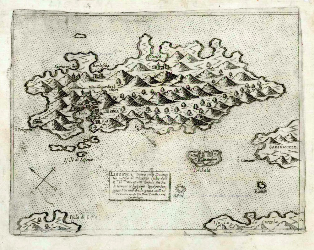
Liesena insula della Dalmatia patria di Demetrio loco delli Ill.mi Si.ri Venetiani riccha di terra et de bestiami Qual per longezze tien mill. 60 largezza mill 25. After 1575
Croatia - Lesina by Giovanni Francesco Camocio
[Item number: 27543]
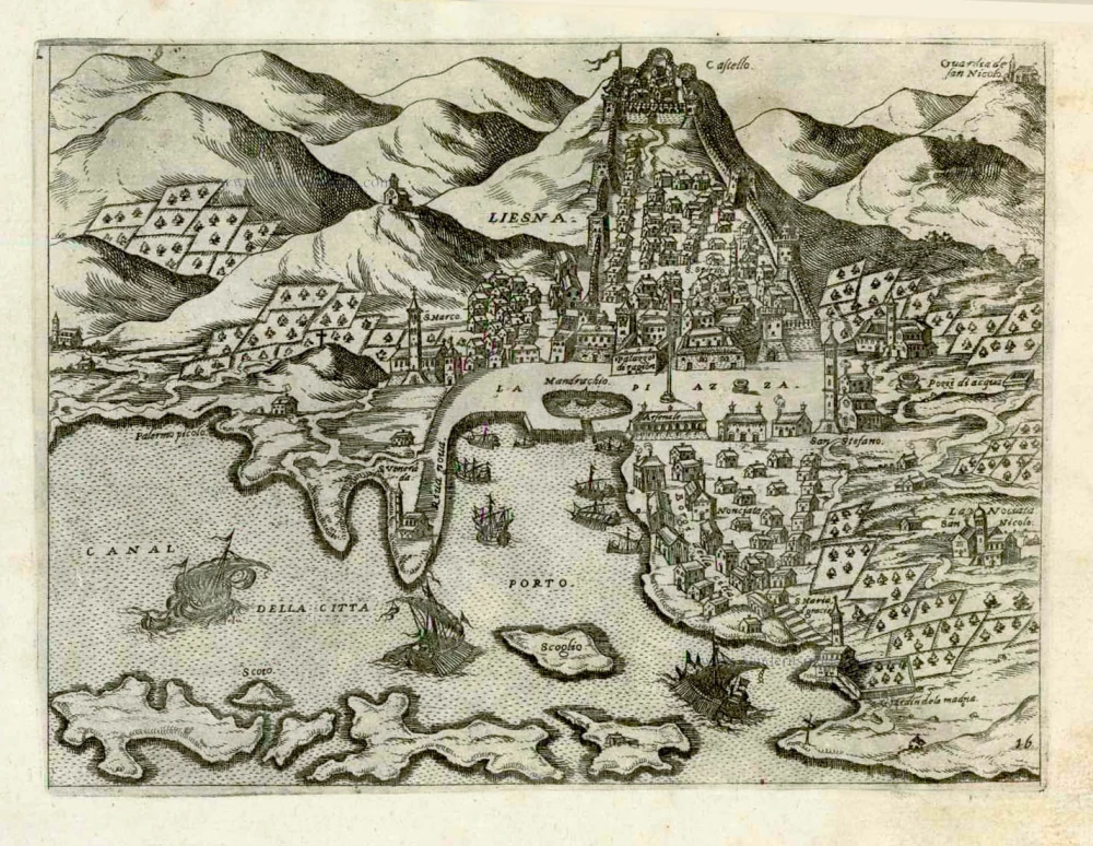
Liesna. After 1575
Croatia - Hkvar (Liesena) by Giovanni Francesco Camocio
[Item number: 27544]

[No title - Castel Novo, Citta di Ragusi, Citta di Cataro.] After 1575
(Croatia - Montenegro) Dubrovnik, Herceg Novi, Kotor (Cattaro) by Giovanni Francesco Camocio
[Item number: 27548]
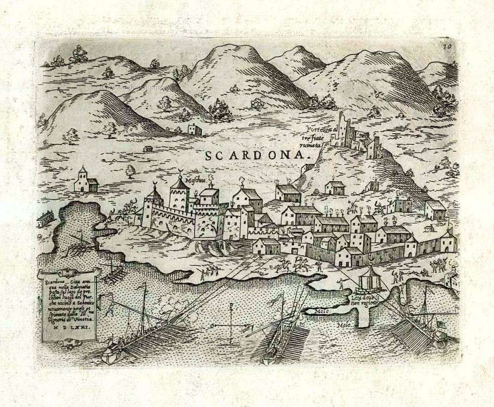
Scardona citta antiqua nella Dalmatia posta su lago de pruchlian luogo del Turcho vicino a Sebenico ... After 1575
Croatia - Skradin (Scardona) by Giovanni Francesco Camocio
[Item number: 27552]
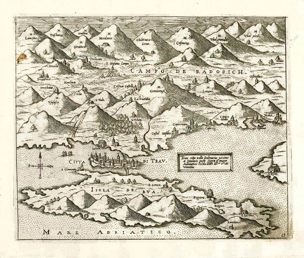
Trau citta nella Dalmacia vicino a Spalato posto sopra il mare Adriatico ... After 1575
Croatia - Trogir (Traù) by Giovanni Francesco Camocio
[Item number: 27554]