
First edition
Romania - Bulgaria, by Abraham Ortelius. 1595
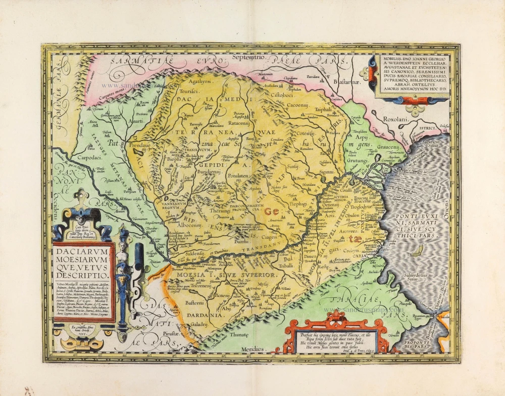
A magnificent and finely engraved historical map of ancient Dacia and Moesia, encompassing present-day Romania, Bulgaria, Moldova, and parts of Serbia, Hungary and Ukraine. Published by Abraham Ortelius in Antwerp in 1595, this is one of the earliest detailed printed maps devoted specifically to the ancient geography of the lower Danube region.
The map depicts the territories of the ancient Dacians, Getae and Moesians, extending from the Carpathian Mountains in the north to the Balkan Mountains in the south, and from the plains of Pannonia in the west to the Black Sea (Pontus Euxinus) in the east. The Danube (Danubius), the principal geographical feature of the region, winds across the centre of the map, separating Dacia from Moesia. Numerous ancient tribes, settlements, rivers and mountain ranges are identified, reflecting Ortelius's extensive study of classical geographical and historical sources.
Particularly noteworthy is the representation of the ancient peoples inhabiting the region, including the Dacians, Getae, Sarmatians, Roxolani, Bastarnae and Scythians. The map also identifies numerous smaller tribal territories and ancient settlements, illustrating the complex ethnic and political geography of southeastern Europe during classical antiquity.
The elaborate decorative elements are characteristic of Ortelius's finest cartographic work. In the lower left, a splendid architectural title cartouche is embellished with strapwork, a female figure, and ornamental details. The cartouche contains an extensive list of ancient place names and a reference to the year 1595. At upper right, an elegant dedication cartouche honours Johann Georg von Werdenstein (1542–1608), a distinguished German ecclesiastic, scholar and collector, to whom Ortelius dedicated the map. A further decorative cartouche at the bottom contains a Latin quotation on the region's ancient geography.
The map was prepared by Ortelius himself, as indicated by the inscription Ex conatibus Abrahami Ortelij, and first appeared in the 1595 edition of his celebrated Theatrum Orbis Terrarum. It belongs to the historical cartographic tradition Ortelius developed in his Parergon, a supplementary collection of maps illustrating the geography of the ancient world. The Parergon is widely regarded as one of the earliest systematic attempts to reconstruct classical geography through printed cartography.
An important and highly decorative example of Renaissance historical cartography, combining Ortelius's antiquarian scholarship with the artistic refinement of late sixteenth-century Flemish engraving.
Abraham Ortelius (1527-1598)
The maker of the 'first atlas', the Theatrum Orbis Terrarum (1570), was born on 4 April 1527 into an old Antwerp family. He learned Latin and studied Greek and mathematics.
Abraham and his sisters, Anne and Elizabeth, took up map colouring. Ortelius was admitted to the Guild of St. Luke as an "illuminator of maps." In addition to colouring maps, Ortelius was a dealer in antiques, coins, maps, and books, and the book and map trade gradually became his primary occupation.
Business went well because his means allowed him to amass an extensive collection of medals, coins, and antiques, as well as a library of many volumes. In addition, he travelled extensively, visited Italy and France, made contacts with scholars and editors everywhere, and maintained extensive correspondence with them.
In 1564, he published his first map, a large and ambitious world wall map. The inspiration for this map may well have been Gastaldi's large world map. In 1565, he published a map of Egypt and a map of the Holy Land; a large map of Asia followed.
In 1568, the production of individual maps for his atlas Theatrum Orbis Terrarum was already in full swing. He completed the atlas in 1569, and in May 1570, it was available for sale. It was one of the most expensive books ever published.
This first edition contained seventy maps on fifty-three sheets. Franciscus Hogenberg engraved the maps.
Later editions included Additamenta (additions), resulting in Ortelius' historical atlas, the Parergon, which is mainly bound together with the atlas. The Parergon can be considered a truly original work by Ortelius, who drew the maps based on his research.
The importance of the Theatrum Orbis Terrarum for geographical knowledge in the last quarter of the sixteenth century is difficult to overemphasise. Nothing was like it until Mercator's atlas appeared twenty-five years later. Demand for the Theatrum was remarkable. Some 24 editions appeared during Ortelius's lifetime, and another 10 after he died in 1598. Editions were published in Dutch, German, French, Spanish, English, and Italian. The number of map sheets grew from 53 in 1570 to 167 in the last edition in 1612.
In 1577, engraver Philip Galle and poet-translator Pieter Heyns published the first pocket-sized edition of the Theatrum, the Epitome. The work was trendy. Over thirty editions of this Epitome were published in different languages.
Ortelius is also remembered for an early idea resembling continental drift: he suggested that the Americas, Europe, and Africa may once have been joined together before separating over time. His work helped shape the development of modern geography and mapmaking.
Daciarum Moesiarumque, Vetus Descriptio.
Item Number: 33398 new Authenticity Guarantee
Category: Antique maps > Europe > Southeastern Europe
Romania - Bulgaria, by Abraham Ortelius.
Title: Daciarum Moesiarumque, Vetus Descriptio.
Ex conatibus Abrahami Ortelij. 1595.
Date of the first edition: 1595.
Date of this map: 1595.
Date on map: 1595.
Copper engraving, printed on paper.
Image size: 350 x 460mm (13¾ x 18 inches).
Sheet size: 470 x 600mm (18½ x 23½ inches).
Verso: Latin text.
Condition: Hand-coloured, excellent.
Condition Rating: A+.
From: Theatrum Orbis Terrarum. Antwerp, Plantin Press, 1595. (Van der Krogt 3, 31:051)
A magnificent and finely engraved historical map of ancient Dacia and Moesia, encompassing present-day Romania, Bulgaria, Moldova, and parts of Serbia, Hungary and Ukraine. Published by Abraham Ortelius in Antwerp in 1595, this is one of the earliest detailed printed maps devoted specifically to the ancient geography of the lower Danube region.
The map depicts the territories of the ancient Dacians, Getae and Moesians, extending from the Carpathian Mountains in the north to the Balkan Mountains in the south, and from the plains of Pannonia in the west to the Black Sea (Pontus Euxinus) in the east. The Danube (Danubius), the principal geographical feature of the region, winds across the centre of the map, separating Dacia from Moesia. Numerous ancient tribes, settlements, rivers and mountain ranges are identified, reflecting Ortelius's extensive study of classical geographical and historical sources.
Particularly noteworthy is the representation of the ancient peoples inhabiting the region, including the Dacians, Getae, Sarmatians, Roxolani, Bastarnae and Scythians. The map also identifies numerous smaller tribal territories and ancient settlements, illustrating the complex ethnic and political geography of southeastern Europe during classical antiquity.
The elaborate decorative elements are characteristic of Ortelius's finest cartographic work. In the lower left, a splendid architectural title cartouche is embellished with strapwork, a female figure, and ornamental details. The cartouche contains an extensive list of ancient place names and a reference to the year 1595. At upper right, an elegant dedication cartouche honours Johann Georg von Werdenstein (1542–1608), a distinguished German ecclesiastic, scholar and collector, to whom Ortelius dedicated the map. A further decorative cartouche at the bottom contains a Latin quotation on the region's ancient geography.
The map was prepared by Ortelius himself, as indicated by the inscription Ex conatibus Abrahami Ortelij, and first appeared in the 1595 edition of his celebrated Theatrum Orbis Terrarum. It belongs to the historical cartographic tradition Ortelius developed in his Parergon, a supplementary collection of maps illustrating the geography of the ancient world. The Parergon is widely regarded as one of the earliest systematic attempts to reconstruct classical geography through printed cartography.
An important and highly decorative example of Renaissance historical cartography, combining Ortelius's antiquarian scholarship with the artistic refinement of late sixteenth-century Flemish engraving.
Abraham Ortelius (1527-1598)
The maker of the 'first atlas', the Theatrum Orbis Terrarum (1570), was born on 4 April 1527 into an old Antwerp family. He learned Latin and studied Greek and mathematics.
Abraham and his sisters, Anne and Elizabeth, took up map colouring. Ortelius was admitted to the Guild of St. Luke as an "illuminator of maps." In addition to colouring maps, Ortelius was a dealer in antiques, coins, maps, and books, and the book and map trade gradually became his primary occupation.
Business went well because his means allowed him to amass an extensive collection of medals, coins, and antiques, as well as a library of many volumes. In addition, he travelled extensively, visited Italy and France, made contacts with scholars and editors everywhere, and maintained extensive correspondence with them.
In 1564, he published his first map, a large and ambitious world wall map. The inspiration for this map may well have been Gastaldi's large world map. In 1565, he published a map of Egypt and a map of the Holy Land; a large map of Asia followed.
In 1568, the production of individual maps for his atlas Theatrum Orbis Terrarum was already in full swing. He completed the atlas in 1569, and in May 1570, it was available for sale. It was one of the most expensive books ever published.
This first edition contained seventy maps on fifty-three sheets. Franciscus Hogenberg engraved the maps.
Later editions included Additamenta (additions), resulting in Ortelius' historical atlas, the Parergon, which is mainly bound together with the atlas. The Parergon can be considered a truly original work by Ortelius, who drew the maps based on his research.
The importance of the Theatrum Orbis Terrarum for geographical knowledge in the last quarter of the sixteenth century is difficult to overemphasise. Nothing was like it until Mercator's atlas appeared twenty-five years later. Demand for the Theatrum was remarkable. Some 24 editions appeared during Ortelius's lifetime, and another 10 after he died in 1598. Editions were published in Dutch, German, French, Spanish, English, and Italian. The number of map sheets grew from 53 in 1570 to 167 in the last edition in 1612.
In 1577, engraver Philip Galle and poet-translator Pieter Heyns published the first pocket-sized edition of the Theatrum, the Epitome. The work was trendy. Over thirty editions of this Epitome were published in different languages.
Ortelius is also remembered for an early idea resembling continental drift: he suggested that the Americas, Europe, and Africa may once have been joined together before separating over time. His work helped shape the development of modern geography and mapmaking.
Related items

Illyricum Orientis In quo Partes II. Moesia et Thracia. 1665
Eastern Illyricum (today's Bulgaria - Rumania), by Guillaume Sanson.
[Item number: 30041]

Transylvania. c. 1610-1650
Romania - Transylvania by Gerard Mercator, published by Henricus Hondius.
[Item number: 31206]

Temeswar. c. 1690
Timisoara (Temesvár) (Romania) by J. Peeters.
[Item number: 31403]

Principati di Moldavia, e Vallachia 1779-1785
Moldavia - Southern Romania, by Antonio Zatta.
[Item number: 32316]

Claudiopolis Coloswar vulgo Clausenburg Transilvaniae civitas primaria. 1635
Cluj-Napoca by Braun and Hogenberg
[Item number: 32696]
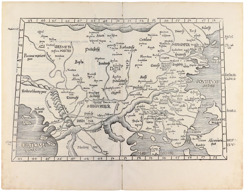
Tabula .IX. Europae. [Title on verso] 1525
Southeastern Europe (Hungary, Rumania, Bulgaria, Bosphorus), by Lorenz Fries.
[Item number: 32717]