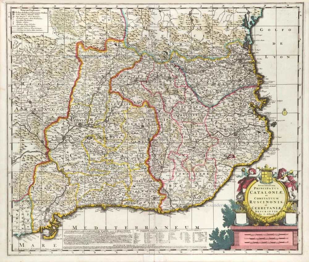
Catalonia (Catalunya) by Carel Allard. c. 1709


The Allard Family
The founder of this family of map-makers, publishers and print-sellers was Huych (Hugo) Allard (1625-1691). He worked in Amsterdam in 1684 and is supposed to have begun his business as early as 1645. He died in 1691, leaving his shop to his son, Carel Allard (1648-c. 1706). Carel brought out many maps and some atlases. His atlases are mainly composed of maps from the stock of other publishers like Janssonius and De Wit. However, some maps were his original creations. The States of Holland granted him a privilege for these maps in 1683.
One of the sons of Carel, Abraham Allard (1676-c.1730), joined his father in the map trade and was accepted as a member of the ‘Constvercoopers gilde’ (Art dealer’s Guild) in 1708.
The original geographical maps by Allard, designed and cut between 1680 and 1700, are very decorative, well-composed and up-to-date.
Accuratissima Principatus Cataloniae, et Comitatuum Ruscinonis, et Cerretaniae Descriptio.
Item Number: 29549 Authenticity Guarantee
Category: Antique maps > Europe > Spain and Portugal
Scarce, antique map of Catalonia (Catalunya) by Carel Allard.
Title: Accuratissima Principatus Cataloniae, et Comitatuum Ruscinonis, et Cerretaniae Descriptio.
Per C. Allard.
Tot Amsterdam by C. Allard, op den Dam met Privilegie enz.
Date: c. 1709.
Copper engraving, printed on paper.
Map size: 500 x 585mm (19.69 x 23.03 inches).
Sheet size: 510 x 620mm (20.10 x 24.41 inches).
Verso: Blank.
Condition: Original coloured, excellent.
Condition Rating: A+.
From: Variae tabulae geographicae un quibus loca in orbe bello flagrantia conspiciuntur ut in Flandria, Brabantia, Leodiensi Tractu, Germania, Hungaria, . . . Diverses cartes de geographie, où l'in peut voir le theatre de la guerre dans tout le monde. Comme dans les pais de Flandres, de Brabant, de Liège, d'Allemagne, de Hongrie, . . . Den Haag, P. Husson, s.d. (c. 1709). (Koeman II, p. 155, Hus1)
The Allard Family
The founder of this family of map-makers, publishers and print-sellers was Huych (Hugo) Allard (1625-1691). He worked in Amsterdam in 1684 and is supposed to have begun his business as early as 1645. He died in 1691, leaving his shop to his son, Carel Allard (1648-c. 1706). Carel brought out many maps and some atlases. His atlases are mainly composed of maps from the stock of other publishers like Janssonius and De Wit. However, some maps were his original creations. The States of Holland granted him a privilege for these maps in 1683.
One of the sons of Carel, Abraham Allard (1676-c.1730), joined his father in the map trade and was accepted as a member of the ‘Constvercoopers gilde’ (Art dealer’s Guild) in 1708.
The original geographical maps by Allard, designed and cut between 1680 and 1700, are very decorative, well-composed and up-to-date.