
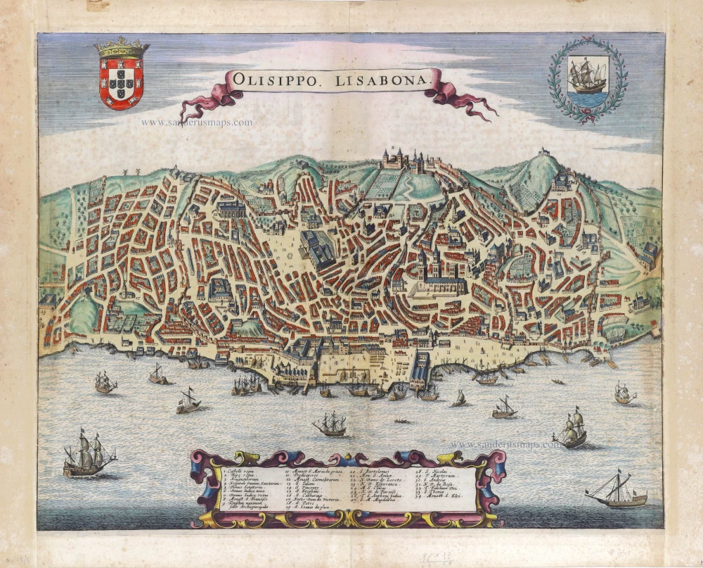
Lisbon (Lisboa) by Georg Braun & Frans Hogenberg. 1623

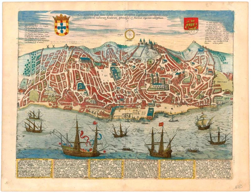


TRANSLATION OF CAPTION: Olisippo, which is today called Lisbon, the largest city of Lusitania, is situated on the Tejo. The most moted centre of trade for the entire Orient, for many islands, for Africa and America.
COMMENTARY BY BRAUN: "In historical times there were two cities we might call "Ruler of the oceans and the high seas", from where ships could set sail for the East and the West: one is Seville, the other Lisbon. [...] Lisbon is one of three episcopal cities within the Kingdom of Spain, whose main church, the Catedral Se Patriarcal, is magnificently decorated and worth seeing."
The combination of a side view and bird's-eye view emphasizes the city's geographical situation. A legend allows us to identify famous buildings such as the Castelo de São Jorge (1) on the skyline, which was conquered by the Moors early on, in the 8th century AD, and restored to Portuguese possession by Alfonso I as late as 1147. Today the ruined fortress offers the best view of the city. Beneath it lies the Romanesque and Gothic cathedral of Se Patriarcal (79). Lying immediately beside the Tejo is the Lower Town of Baixa, bounded by the hill bearing the fortress and the Upper Town of Bairro Alto. As two-thirds of Lisbon was destroyed by an earthquake on 1 November 1755, the illustrations in the Civitates Orbis Terrarum provide important records of the city's former appearance. After the earthquake, the Lower Town was rebuilt in the style of the 18th century. (Taschen)
Braun G. & Hogenberg F. and the Civitates Orbis Terrarum.
The Civitates Orbis Terrarum, also known as the 'Braun & Hogenberg', is a six-volume town atlas and the most excellent book of town views and plans ever published: 363 engravings, sometimes beautifully coloured. It was one of the best-selling works in the last quarter of the 16th century. Georg Braun, a skilled writer, wrote the text accompanying the plans and views on the verso. Many plates were engraved after the original drawings of a professional artist, Joris Hoefnagel (1542-1600). The first volume was published in Latin in 1572 and the sixth in 1617. Frans Hogenberg, a talented engraver, created the tables for volumes I through IV, and Simon van den Neuwel made those for volumes V and VI. Other contributors were cartographers Daniel Freese and Heinrich Rantzau, who provided valuable geographical information. Works by Jacob van Deventer, Sebastian Münster, and Johannes Stumpf were also used as references. Translations appeared in German and French, making the atlas accessible to a broader audience.
Since its original publication of volume 1 in 1572, the Civitates Orbis Terrarum has left an indelible mark on the history of cartography. Seven more editions followed the first volume in 1575, 1577, 1582, 1588, 1593, 1599, and 1612. Vol.2, initially released in 1575, saw subsequent editions in 1597 and 1612. The subsequent volumes, each a treasure trove of historical insights, graced the world in 1581, 1588, 1593, 1599, and 1606. The German translation of the first volume, a testament to its widespread appeal, debuted in 1574, followed by the French edition in 1575.
Several printers were involved: Theodor Graminaeus, Heinrich von Aich, Gottfried von Kempen, Johannis Sinniger, Bertram Buchholtz, and Peter von Brachel, all of whom worked in Cologne.
Georg Braun (1541-1622)
Georg Braun, the author of the text accompanying the plans and views in the Civitates Orbis Terrarum, was born in Cologne in 1541. After his studies in Cologne, he entered the Jesuit Order as a novice, indicating his commitment to learning and intellectual pursuits. In 1561, he obtained his bachelor's degree; in 1562, he received his Magister Artium, further demonstrating his academic achievements. Although he left the Jesuit Order, he continued his studies in theology, gaining a licentiate in theology. His theological background likely influenced the content and tone of the text in the Civitates Orbis Terrarum, adding a unique perspective to the work.
Frans Hogenberg (1535-1590)
Frans Hogenberg was a Flemish and German painter, engraver, and mapmaker. He was born in Mechelen as the son of Nicolaas Hogenberg.
By the end of the 1560s, Frans Hogenberg was employed upon Abraham Ortelius's Theatrum Orbis Terrarum, published in 1570; he is named an engraver of numerous maps. In 1568, he was banned from Antwerp by the Duke of Alva and travelled to London, where he stayed a few years before emigrating to Cologne. He immediately embarked on his two most important works, the Civitates, published in 1572 and the Geschichtsblätter, which appeared in several series from 1569 until about 1587.
Thanks to large-scale projects like the Geschichtsblätter and the Civitates, Hogenberg's social circumstances improved with each passing year. He died as a wealthy man in Cologne in 1590.
Olissippo quae nunc Lisboa, Civitas Amplissima Lusitaniae, ad Tagum, totiq Orientis, et multarum Insularum Aphricaeque et Americae emporium nobilissimum.
Item Number: 16483 Authenticity Guarantee
Category: Antique maps > Europe > Spain and Portugal
Old, antique bird’s-eye view plan of Lisbon (Lissabon), by Georg Braun & Frans Hogenberg.
Lisbon (Lisboa)
Title: Olissippo quae nunc Lisboa, Civitas Amplissima Lusitaniae, ad Tagum, totiq Orientis, et multarum Insularum Aphricaeque et Americae emporium nobilissimum.
Date of the first edition: 1596.
Date of this map: 1623.
Copper engraving, printed on paper.
Size (not including margins): 365 x 467mm (14.37 x 18.39 inches).
Verso: Latin text.
Condition: Excellent, superb old colour.
Condition Rating: A+.
References: Van der Krogt 4, 2399 State 2; Taschen, Br. Hog., p.350; Fauser, #7860
From: Urbium Praeipuarum Mundi Theatrum Quintum Auctore Georgio Braunio Agrippinate. Part 5. Köln, Petrus von Brachel, 1623. (Van der Krogt 4, 41:1.5)
TRANSLATION OF CAPTION: Olisippo, which is today called Lisbon, the largest city of Lusitania, is situated on the Tejo. The most moted centre of trade for the entire Orient, for many islands, for Africa and America.
COMMENTARY BY BRAUN: "In historical times there were two cities we might call "Ruler of the oceans and the high seas", from where ships could set sail for the East and the West: one is Seville, the other Lisbon. [...] Lisbon is one of three episcopal cities within the Kingdom of Spain, whose main church, the Catedral Se Patriarcal, is magnificently decorated and worth seeing."
The combination of a side view and bird's-eye view emphasizes the city's geographical situation. A legend allows us to identify famous buildings such as the Castelo de São Jorge (1) on the skyline, which was conquered by the Moors early on, in the 8th century AD, and restored to Portuguese possession by Alfonso I as late as 1147. Today the ruined fortress offers the best view of the city. Beneath it lies the Romanesque and Gothic cathedral of Se Patriarcal (79). Lying immediately beside the Tejo is the Lower Town of Baixa, bounded by the hill bearing the fortress and the Upper Town of Bairro Alto. As two-thirds of Lisbon was destroyed by an earthquake on 1 November 1755, the illustrations in the Civitates Orbis Terrarum provide important records of the city's former appearance. After the earthquake, the Lower Town was rebuilt in the style of the 18th century. (Taschen)
Braun G. & Hogenberg F. and the Civitates Orbis Terrarum.
The Civitates Orbis Terrarum, also known as the 'Braun & Hogenberg', is a six-volume town atlas and the most excellent book of town views and plans ever published: 363 engravings, sometimes beautifully coloured. It was one of the best-selling works in the last quarter of the 16th century. Georg Braun, a skilled writer, wrote the text accompanying the plans and views on the verso. Many plates were engraved after the original drawings of a professional artist, Joris Hoefnagel (1542-1600). The first volume was published in Latin in 1572 and the sixth in 1617. Frans Hogenberg, a talented engraver, created the tables for volumes I through IV, and Simon van den Neuwel made those for volumes V and VI. Other contributors were cartographers Daniel Freese and Heinrich Rantzau, who provided valuable geographical information. Works by Jacob van Deventer, Sebastian Münster, and Johannes Stumpf were also used as references. Translations appeared in German and French, making the atlas accessible to a broader audience.
Since its original publication of volume 1 in 1572, the Civitates Orbis Terrarum has left an indelible mark on the history of cartography. Seven more editions followed the first volume in 1575, 1577, 1582, 1588, 1593, 1599, and 1612. Vol.2, initially released in 1575, saw subsequent editions in 1597 and 1612. The subsequent volumes, each a treasure trove of historical insights, graced the world in 1581, 1588, 1593, 1599, and 1606. The German translation of the first volume, a testament to its widespread appeal, debuted in 1574, followed by the French edition in 1575.
Several printers were involved: Theodor Graminaeus, Heinrich von Aich, Gottfried von Kempen, Johannis Sinniger, Bertram Buchholtz, and Peter von Brachel, all of whom worked in Cologne.
Georg Braun (1541-1622)
Georg Braun, the author of the text accompanying the plans and views in the Civitates Orbis Terrarum, was born in Cologne in 1541. After his studies in Cologne, he entered the Jesuit Order as a novice, indicating his commitment to learning and intellectual pursuits. In 1561, he obtained his bachelor's degree; in 1562, he received his Magister Artium, further demonstrating his academic achievements. Although he left the Jesuit Order, he continued his studies in theology, gaining a licentiate in theology. His theological background likely influenced the content and tone of the text in the Civitates Orbis Terrarum, adding a unique perspective to the work.
Frans Hogenberg (1535-1590)
Frans Hogenberg was a Flemish and German painter, engraver, and mapmaker. He was born in Mechelen as the son of Nicolaas Hogenberg.
By the end of the 1560s, Frans Hogenberg was employed upon Abraham Ortelius's Theatrum Orbis Terrarum, published in 1570; he is named an engraver of numerous maps. In 1568, he was banned from Antwerp by the Duke of Alva and travelled to London, where he stayed a few years before emigrating to Cologne. He immediately embarked on his two most important works, the Civitates, published in 1572 and the Geschichtsblätter, which appeared in several series from 1569 until about 1587.
Thanks to large-scale projects like the Geschichtsblätter and the Civitates, Hogenberg's social circumstances improved with each passing year. He died as a wealthy man in Cologne in 1590.
Related items
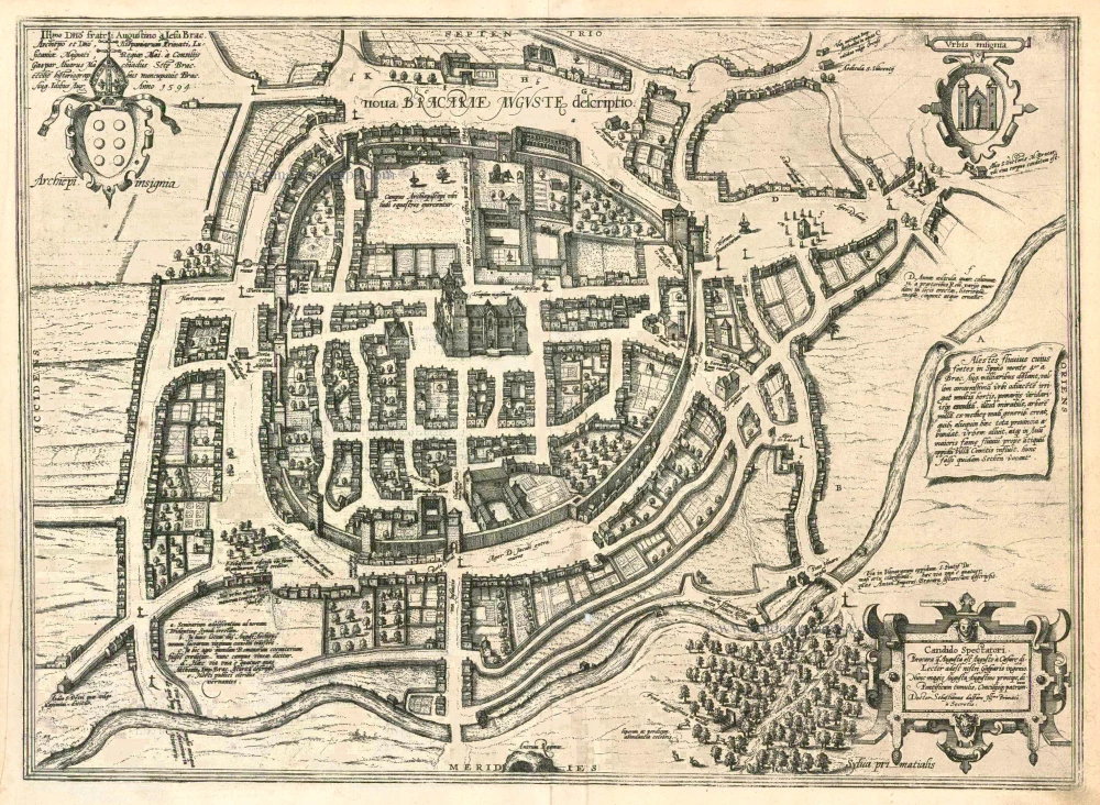
Nova Bracarae Auguste Descriptio. 1596
Braga, by Georg Braun and Frans Hogenberg.
[Item number: 24134]
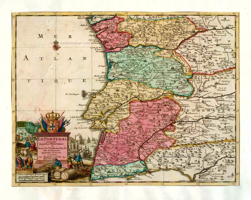
Le Portugal. 1713
Portugal, by Pieter van der Aa.
[Item number: 26086]
Olisippo Lisabona. 1657
Lisbon (Lisboa) by Joannes Janssonius.
[Item number: 29596]