
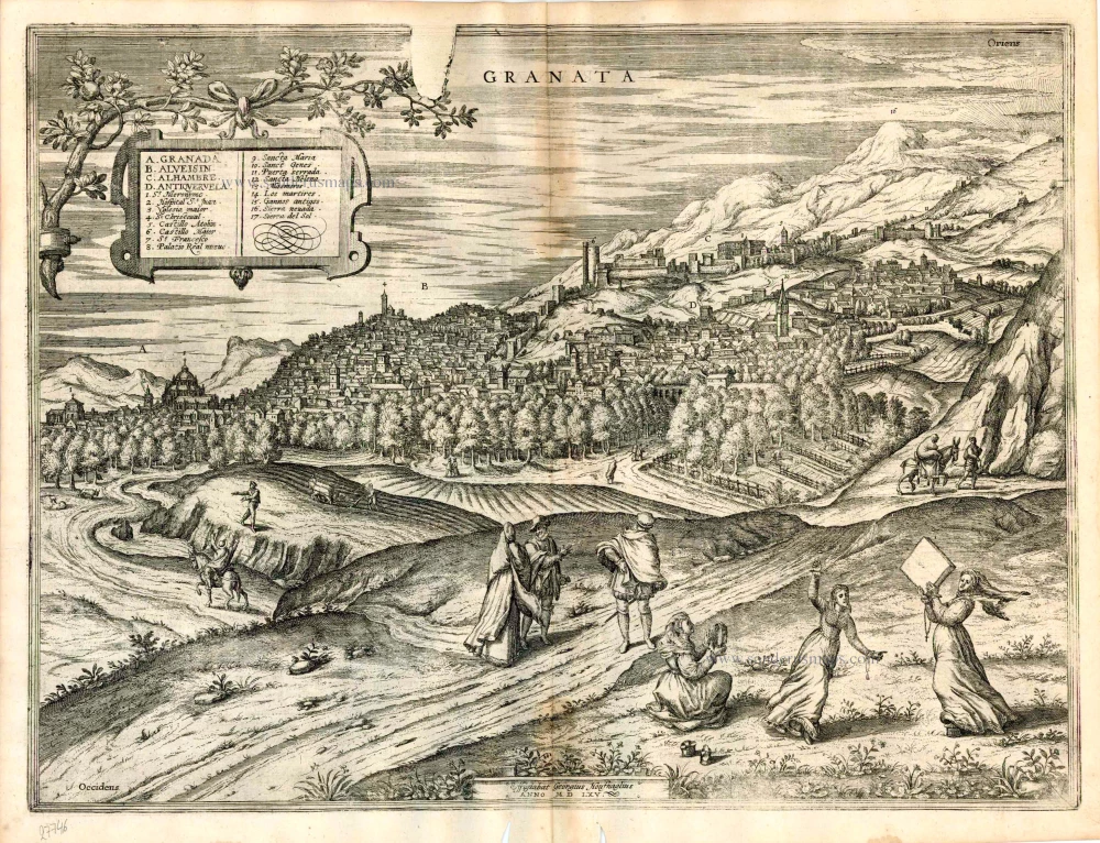
Granada by Georg Braun & Frans Hogenberg c. 1610
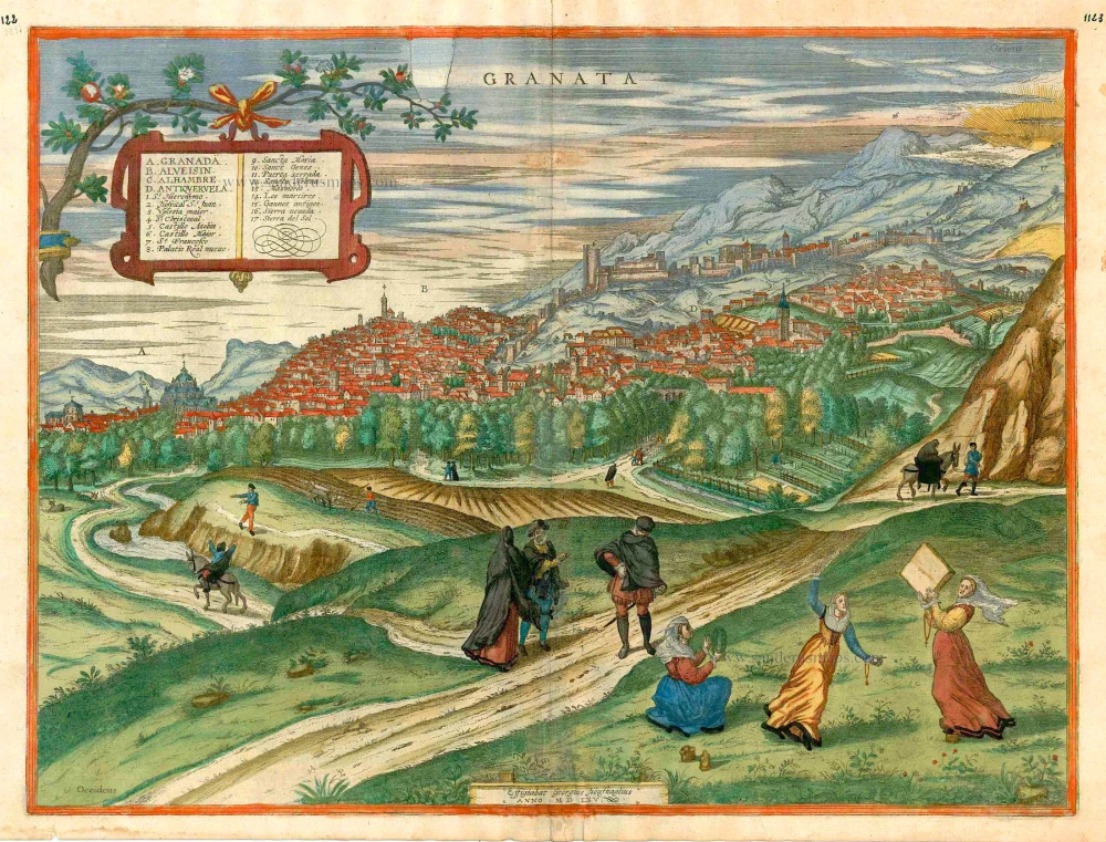


COMMENTARY BY BRAUN (on verso): "[...] In this fifth volume of the city atlas, we show how the noble and royal city of Granada appears from the west so that other parts of the city, including the Alhambra, can be seen better. [...] Antequeruela is a densely populated quarter of Granada, whose inhabitants are called Antequeruelans. They produce silk, velvet, crimson and damask, and other valuable fabrics, in large quantities and numbers." A magnificent panoramic view of Granada in which the city's various quarters are recognizable. The city centre (A) is followed on the right by the two districts of Albaicin (B) and Antequeruela (D) and above them the Alhambra (C). Albacin was founded in 1246 by Moors fleeing from Baeza to Granada. Antequeruela was founded in 1410 by Moorish refugees from Antequera. As mentioned by Braun, Silk production flourished in Granada under the rule of the Nasrids (1238-1493). During this period, trade in silk with Italy led Granada to become the wealthiest city in Spain. The arts and sciences also flourished under the rule: Yusuf I founded the Arab university of La Madraza in Granada as early as 1349; the Christian university that succeeded was created under Emperor Charles V in 1531. (Taschen)
Braun G. & Hogenberg F. and the Civitates Orbis Terrarum.
The Civitates Orbis Terrarum, or the "Braun & Hogenberg", is a six-volume town atlas and the most excellent book of town views and plans ever published: 363 engravings, sometimes beautifully coloured. It was one of the best-selling works in the last quarter of the 16th century. Georg Braun wrote the text accompanying the plans and views on the verso. Many plates were engraved after the original drawings of a professional artist, a professional artist, Joris Hoefnagel (1542-1600). The first volume was published in Latin in 1572, and the sixth in 1617. Frans Hogenberg created the tables for volumes I through IV, and Simon van den Neuwel made those for volumes V and VI. Other contributors were cartographers Daniel Freese and Heinrich Rantzau. Works by Jacob van Deventer, Sebastian Münster, and Johannes Stumpf were also used. Translations appeared in German and French.
Following the original publication of Volume 1 of the Civitates in 1572, seven further editions of 1575, 1577, 1582, 1588, 1593, 1599 and 1612 can be identified. Vol.2, first issued in 1575, was followed by further editions in 1597 and 1612. The subsequent volumes appeared in 1581, 1588, 1593, 1599 and 1606. The German translation of the first volume appeared from 1574 on, and the French edition from 1575 on.
Several printers were involved: Theodor Graminaeus, Heinrich von Aich, Gottfried von Kempen, Johannis Sinniger, Bertram Buchholtz and Peter von Brachel, who all worked in Cologne.
Georg Braun (1541-1622)
Georg Braun was born in Cologne in 1541. After his studies in Cologne, he entered the Jesuit Order as a novice. 1561, he obtained his bachelor's degree, and in 1562, he received his Magister Artium. Although he left the Jesuit Order, he studied theology, gaining a licentiate in theology.
Frans Hogenberg (1535-1590)
Frans Hogenberg was a Flemish and German painter, engraver, and mapmaker. He was born in Mechelen as the son of Nicolaas Hogenberg.
By the end of the 1560s, Frans Hogenberg was employed upon Abraham Ortelius's Theatrum Orbis Terrarum, published in 1570; he is named an engraver of numerous maps. In 1568, he was banned from Antwerp by the Duke of Alva and travelled to London, where he stayed a few years before emigrating to Cologne. He immediately embarked on his two most important works, the Civitates, published in 1572 and the Geschichtsblätter, which appeared in several series from 1569 until about 1587.
Thanks to large-scale projects like the Geschichtsblätter and the Civitates, Hogenberg's social circumstances improved with each passing year. He died as a wealthy man in Cologne in 1590.
Granata.
Item Number: 24592 Authenticity Guarantee
Category: Antique maps > Europe > Spain and Portugal
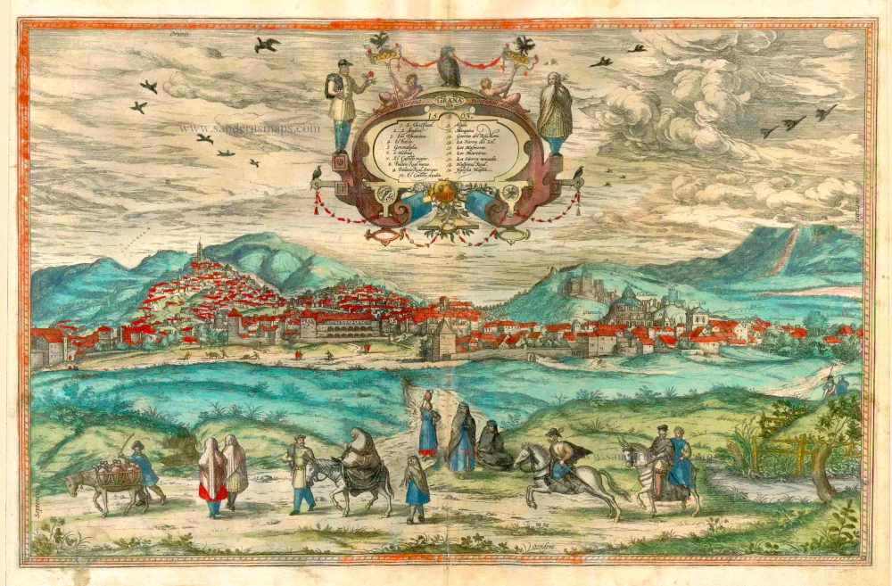
Old, antique map - bird's-eye view of Granada by Braun & Hogenberg, drawn by Georg Hoefnagel in the year 1565.
COMMENTARY BY BRAUN (on verso): "[...] Now in this fifth volume of the city atlas we show how the noble and royal city of Granada appears from the west, so that other parts of the city, including the Alhambra, can be seen better. [...] Antequeruela is a denseley populated quarter of Granada, whose inhabitants are called Antequeruelans. They produce silk, velvet, crimson and damask, and other valuable fabrics, in large quantities and numbers."
A magnificent panoramic view of Granada in which the city's various quarters are clearly recognizable. The city centre (A) is followed on the right by the two districts of Albaicin (B) and Antequeruela (D), and above them the Alhambra (C). Albacin was founded in 1246 by Moors fleeing from Baeza to Granada. Antequeruela was founded in 1410 by Moorish refugees from Antequera. Silk production, as mentioned by Braun, flourished in Granada under the rule of the Nasrids (1238-1493). During this period trade in silk with Italy led Granada to become the wealthiest city in Spain. The arts and sciences also flourished under the rule: Yusuf I founded the Arab university of La Madraza in Granada as early as 1349; the Christian university that succeeded it was created under Emperor Charles V in 1531. (Taschen)
Date of the first edition: 1596
Date of this map: c. 1610
Copper engraving
Size: 37.5 x 50.5cm (14.6 x 19.6 inches)
Verso text: French
Condition: Contemporary coloured, lower centrefold split reinforced.
Condition Rating: A
References: Van der Krogt 4, 1597 State 1; Taschen, Braun and Hogenberg, p.361.
From: Théâtre des Principales Villes de tout l'Univers. Tome 5. c. 1610.
COMMENTARY BY BRAUN (on verso): "[...] In this fifth volume of the city atlas, we show how the noble and royal city of Granada appears from the west so that other parts of the city, including the Alhambra, can be seen better. [...] Antequeruela is a densely populated quarter of Granada, whose inhabitants are called Antequeruelans. They produce silk, velvet, crimson and damask, and other valuable fabrics, in large quantities and numbers." A magnificent panoramic view of Granada in which the city's various quarters are recognizable. The city centre (A) is followed on the right by the two districts of Albaicin (B) and Antequeruela (D) and above them the Alhambra (C). Albacin was founded in 1246 by Moors fleeing from Baeza to Granada. Antequeruela was founded in 1410 by Moorish refugees from Antequera. As mentioned by Braun, Silk production flourished in Granada under the rule of the Nasrids (1238-1493). During this period, trade in silk with Italy led Granada to become the wealthiest city in Spain. The arts and sciences also flourished under the rule: Yusuf I founded the Arab university of La Madraza in Granada as early as 1349; the Christian university that succeeded was created under Emperor Charles V in 1531. (Taschen)
Braun G. & Hogenberg F. and the Civitates Orbis Terrarum.
The Civitates Orbis Terrarum, or the "Braun & Hogenberg", is a six-volume town atlas and the most excellent book of town views and plans ever published: 363 engravings, sometimes beautifully coloured. It was one of the best-selling works in the last quarter of the 16th century. Georg Braun wrote the text accompanying the plans and views on the verso. Many plates were engraved after the original drawings of a professional artist, a professional artist, Joris Hoefnagel (1542-1600). The first volume was published in Latin in 1572, and the sixth in 1617. Frans Hogenberg created the tables for volumes I through IV, and Simon van den Neuwel made those for volumes V and VI. Other contributors were cartographers Daniel Freese and Heinrich Rantzau. Works by Jacob van Deventer, Sebastian Münster, and Johannes Stumpf were also used. Translations appeared in German and French.
Following the original publication of Volume 1 of the Civitates in 1572, seven further editions of 1575, 1577, 1582, 1588, 1593, 1599 and 1612 can be identified. Vol.2, first issued in 1575, was followed by further editions in 1597 and 1612. The subsequent volumes appeared in 1581, 1588, 1593, 1599 and 1606. The German translation of the first volume appeared from 1574 on, and the French edition from 1575 on.
Several printers were involved: Theodor Graminaeus, Heinrich von Aich, Gottfried von Kempen, Johannis Sinniger, Bertram Buchholtz and Peter von Brachel, who all worked in Cologne.
Georg Braun (1541-1622)
Georg Braun was born in Cologne in 1541. After his studies in Cologne, he entered the Jesuit Order as a novice. 1561, he obtained his bachelor's degree, and in 1562, he received his Magister Artium. Although he left the Jesuit Order, he studied theology, gaining a licentiate in theology.
Frans Hogenberg (1535-1590)
Frans Hogenberg was a Flemish and German painter, engraver, and mapmaker. He was born in Mechelen as the son of Nicolaas Hogenberg.
By the end of the 1560s, Frans Hogenberg was employed upon Abraham Ortelius's Theatrum Orbis Terrarum, published in 1570; he is named an engraver of numerous maps. In 1568, he was banned from Antwerp by the Duke of Alva and travelled to London, where he stayed a few years before emigrating to Cologne. He immediately embarked on his two most important works, the Civitates, published in 1572 and the Geschichtsblätter, which appeared in several series from 1569 until about 1587.
Thanks to large-scale projects like the Geschichtsblätter and the Civitates, Hogenberg's social circumstances improved with each passing year. He died as a wealthy man in Cologne in 1590.
Related items
Granada 1563. 1582
Granada, by Georg Braun and Frans Hogenberg.
[Item number: 25487]
Granada 1563. 1582
Granada, by Georg Braun & Frans Hogenberg.
[Item number: 26670]
Granata. 1617-18
Granada by Georg Braun & Frans Hogenberg
[Item number: 27746]