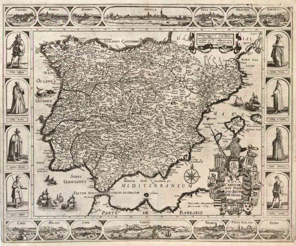
Old, antique map of Spain by Pieter Verbiest 1629
The title cartouche appears at the lower right, surrounded by the coats of arms of the 16 provinces and crowned by a lion with a sword. To the left of this cartouche the Antwerp engraver and publisher Pieter Verbiest II (1605-93) is mentioned as maker and publisher of the map. In the upper right is a simple cartouche with two bar scales and the legend for the symbols used on the map. The seas are decorated by a compass rose, sea monsters and ships. The map image is framed by latitudinal and longitudinal scales. The map is surrounded by decorative borders In the top and bottom borders the larger tpwn view in the centre is flanked at each side by three smaller ones. Top border: Toledo; Burgos; Madrid; Sevilla; Valadolid; Granada; Barcelona. Bottom border: Cadiz; Malaga; Conil; Lisbona; Xeres; Velis Malaga; Ecila. The sie borders show representati!ves of the three social classes. Left: Nobilis Hispanus; Nobilis Femina; Lusitanus Mercator; Rustica Hispana. Right: Nobilis Femina; Nobilis in Castilia; Lusitani Mercatoris; Rusticus Comunis.
One of two recorded examples complete with the borders.
The other copy of this map is in the *Österreichische Nationalbibliothek* in Wien. - No copy in Spain.
Nova Carte del Muy Podr oso Reyno d'Espania
Item Number: 2493 Authenticity Guarantee
Category: Antique maps > Europe > Spain and Portugal
Old, antique map of Spain by Pieter Verbiest.
One of two recorded examples complete with the borders.
Title: Nova Carte del Muy Podr oso Reyno d'Espania
Date of the first edition: 1629.
Date of this map: 1629.
Copper engraving, printed on paper.
Size (not including margins): 453 x 550mm (17.83 x 21.65 inches).
Verso: Blank.
Condition: Lower margin trimmed (new margin added), else excellent.
Condition Rating: A.
Separate publication - from a composite atlas called "Atlas Iprensis"
The title cartouche appears at the lower right, surrounded by the coats of arms of the 16 provinces and crowned by a lion with a sword. To the left of this cartouche the Antwerp engraver and publisher Pieter Verbiest II (1605-93) is mentioned as maker and publisher of the map. In the upper right is a simple cartouche with two bar scales and the legend for the symbols used on the map. The seas are decorated by a compass rose, sea monsters and ships. The map image is framed by latitudinal and longitudinal scales. The map is surrounded by decorative borders In the top and bottom borders the larger tpwn view in the centre is flanked at each side by three smaller ones. Top border: Toledo; Burgos; Madrid; Sevilla; Valadolid; Granada; Barcelona. Bottom border: Cadiz; Malaga; Conil; Lisbona; Xeres; Velis Malaga; Ecila. The sie borders show representati!ves of the three social classes. Left: Nobilis Hispanus; Nobilis Femina; Lusitanus Mercator; Rustica Hispana. Right: Nobilis Femina; Nobilis in Castilia; Lusitani Mercatoris; Rusticus Comunis.
One of two recorded examples complete with the borders.
The other copy of this map is in the *Österreichische Nationalbibliothek* in Wien. - No copy in Spain.

