
Basel, by Georg Braun and Frans Hogenberg. 1575

COMMENTARY BY BRAUN: "The city of Basle consists of two parts, one side, which is on the French side, is called Greater Basle and is very old and a bishopric; it existed already at the time when the Romans were there. The smaller city on the German side has been linked to the greater part by a splendid bridge over the flowing Rhine. [...] No one who has seen this city can deny that it justly called a royal city, "Baslea", due to its fine straight streets and its neatly arranged and well-positioned buildings, all of which are magnificent and beautifully embellished, with lovely, charming gardens, this is where the monastery of St Peter and the Preachers' Monastery are found."
Basle is shown here from the northwest in a bird's-eye view appropriate to its size. In the foreground is Lesser Basle, on the far side of the bridge over the Rhine Greater Basle is protected by a double circular wall, with the late Romanesque and Gothic minster (1) with its two characteristic towers on the west façade, the collegiate church of St Peter (3), the stately town hall with its high tower (4), the university founded in 1460 (6), the Dominican monastery (19, on the right) and the paper mill (12, top left). The Roman town of Augusta Raurica was founded in 44/43 BC; the name Basilea is first mentioned in AD 374. Basle was recorded as a bishopric in 740. In 1356 one of the biggest earthquakes north of the Alps destroyed most of the city; in addition, a disastrous fire broke out. In 1460 Pope Pius II endowed the University of Basle, the oldest university in Switzerland. This attracted many scholars and humanists (Erasmus of Rotterdam, Hans Holbein the Younger, Paracelsus) and Basle became a centre of printing and publishing (Froben). In 1471 Emperor Friedrich III granted Basle the right to hold fairs. After the Swabian War against Emperor Maximilian I in 1499, Basle became independent from the Empire, joining the Old Swiss Confederation together with Schaffhausen in 1501. In 1529 the city accepted the reformed faith and the bishop had to leave the city. Around 1600 Basle had about 12,000 inhabitants, but between 1550 and 1611 there were several outbreaks of the plague and a third of the population died. (Taschen)
Braun G. & Hogenberg F. and the Civitates Orbis Terrarum.
The Civitates Orbis Terrarum, also known as the 'Braun & Hogenberg', is a six-volume town atlas and the most excellent book of town views and plans ever published: 363 engravings, sometimes beautifully coloured. It was one of the best-selling works in the last quarter of the 16th century. Georg Braun, a skilled writer, wrote the text accompanying the plans and views on the verso. Many plates were engraved after the original drawings of a professional artist, Joris Hoefnagel (1542-1600). The first volume was published in Latin in 1572 and the sixth in 1617. Frans Hogenberg, a talented engraver, created the tables for volumes I through IV, and Simon van den Neuwel made those for volumes V and VI. Other contributors were cartographers Daniel Freese and Heinrich Rantzau, who provided valuable geographical information. Works by Jacob van Deventer, Sebastian Münster, and Johannes Stumpf were also used as references. Translations appeared in German and French, making the atlas accessible to a broader audience.
Since its original publication of volume 1 in 1572, the Civitates Orbis Terrarum has left an indelible mark on the history of cartography. Seven more editions followed the first volume in 1575, 1577, 1582, 1588, 1593, 1599, and 1612. Vol.2, initially released in 1575, saw subsequent editions in 1597 and 1612. The subsequent volumes, each a treasure trove of historical insights, graced the world in 1581, 1588, 1593, 1599, and 1606. The German translation of the first volume, a testament to its widespread appeal, debuted in 1574, followed by the French edition in 1575.
Several printers were involved: Theodor Graminaeus, Heinrich von Aich, Gottfried von Kempen, Johannis Sinniger, Bertram Buchholtz, and Peter von Brachel, all of whom worked in Cologne.
Georg Braun (1541-1622)
Georg Braun, the author of the text accompanying the plans and views in the Civitates Orbis Terrarum, was born in Cologne in 1541. After his studies in Cologne, he entered the Jesuit Order as a novice, indicating his commitment to learning and intellectual pursuits. In 1561, he obtained his bachelor's degree; in 1562, he received his Magister Artium, further demonstrating his academic achievements. Although he left the Jesuit Order, he continued his studies in theology, gaining a licentiate in theology. His theological background likely influenced the content and tone of the text in the Civitates Orbis Terrarum, adding a unique perspective to the work.
Frans Hogenberg (1535-1590)
Frans Hogenberg was a Flemish and German painter, engraver, and mapmaker. He was born in Mechelen as the son of Nicolaas Hogenberg.
By the end of the 1560s, Frans Hogenberg was employed upon Abraham Ortelius's Theatrum Orbis Terrarum, published in 1570; he is named an engraver of numerous maps. In 1568, he was banned from Antwerp by the Duke of Alva and travelled to London, where he stayed a few years before emigrating to Cologne. He immediately embarked on his two most important works, the Civitates, published in 1572 and the Geschichtsblätter, which appeared in several series from 1569 until about 1587.
Thanks to large-scale projects like the Geschichtsblätter and the Civitates, Hogenberg's social circumstances improved with each passing year. He died as a wealthy man in Cologne in 1590.
Basilea
Item Number: 9248 Authenticity Guarantee
Category: Antique maps > Europe > Switzerland
Old, antique bird’s-eye view plan of Basel, by Georg Braun & Frans Hogenberg.
With a key to locations.
Title: Basilea
Date of the first edition: 1575.
Date of this map: 1575.
Copper engraving, printed on paper.
Size (not including margins): 375 x 375mm (14.76 x 14.76 inches).
Verso: Latin text.
Condition: Uncoloured, excellent.
Condition Rating: A+
From: Civitates Orbis Terrarum, ... Part 2: De Praecipuis, Totius Universi Urbibus, Liber Secundus. Köln, Gottfried von Kempen, 1575. (Van der Krogt 4, 41:1.2)
COMMENTARY BY BRAUN: "The city of Basle consists of two parts, one side, which is on the French side, is called Greater Basle and is very old and a bishopric; it existed already at the time when the Romans were there. The smaller city on the German side has been linked to the greater part by a splendid bridge over the flowing Rhine. [...] No one who has seen this city can deny that it justly called a royal city, "Baslea", due to its fine straight streets and its neatly arranged and well-positioned buildings, all of which are magnificent and beautifully embellished, with lovely, charming gardens, this is where the monastery of St Peter and the Preachers' Monastery are found."
Basle is shown here from the northwest in a bird's-eye view appropriate to its size. In the foreground is Lesser Basle, on the far side of the bridge over the Rhine Greater Basle is protected by a double circular wall, with the late Romanesque and Gothic minster (1) with its two characteristic towers on the west façade, the collegiate church of St Peter (3), the stately town hall with its high tower (4), the university founded in 1460 (6), the Dominican monastery (19, on the right) and the paper mill (12, top left). The Roman town of Augusta Raurica was founded in 44/43 BC; the name Basilea is first mentioned in AD 374. Basle was recorded as a bishopric in 740. In 1356 one of the biggest earthquakes north of the Alps destroyed most of the city; in addition, a disastrous fire broke out. In 1460 Pope Pius II endowed the University of Basle, the oldest university in Switzerland. This attracted many scholars and humanists (Erasmus of Rotterdam, Hans Holbein the Younger, Paracelsus) and Basle became a centre of printing and publishing (Froben). In 1471 Emperor Friedrich III granted Basle the right to hold fairs. After the Swabian War against Emperor Maximilian I in 1499, Basle became independent from the Empire, joining the Old Swiss Confederation together with Schaffhausen in 1501. In 1529 the city accepted the reformed faith and the bishop had to leave the city. Around 1600 Basle had about 12,000 inhabitants, but between 1550 and 1611 there were several outbreaks of the plague and a third of the population died. (Taschen)
Braun G. & Hogenberg F. and the Civitates Orbis Terrarum.
The Civitates Orbis Terrarum, also known as the 'Braun & Hogenberg', is a six-volume town atlas and the most excellent book of town views and plans ever published: 363 engravings, sometimes beautifully coloured. It was one of the best-selling works in the last quarter of the 16th century. Georg Braun, a skilled writer, wrote the text accompanying the plans and views on the verso. Many plates were engraved after the original drawings of a professional artist, Joris Hoefnagel (1542-1600). The first volume was published in Latin in 1572 and the sixth in 1617. Frans Hogenberg, a talented engraver, created the tables for volumes I through IV, and Simon van den Neuwel made those for volumes V and VI. Other contributors were cartographers Daniel Freese and Heinrich Rantzau, who provided valuable geographical information. Works by Jacob van Deventer, Sebastian Münster, and Johannes Stumpf were also used as references. Translations appeared in German and French, making the atlas accessible to a broader audience.
Since its original publication of volume 1 in 1572, the Civitates Orbis Terrarum has left an indelible mark on the history of cartography. Seven more editions followed the first volume in 1575, 1577, 1582, 1588, 1593, 1599, and 1612. Vol.2, initially released in 1575, saw subsequent editions in 1597 and 1612. The subsequent volumes, each a treasure trove of historical insights, graced the world in 1581, 1588, 1593, 1599, and 1606. The German translation of the first volume, a testament to its widespread appeal, debuted in 1574, followed by the French edition in 1575.
Several printers were involved: Theodor Graminaeus, Heinrich von Aich, Gottfried von Kempen, Johannis Sinniger, Bertram Buchholtz, and Peter von Brachel, all of whom worked in Cologne.
Georg Braun (1541-1622)
Georg Braun, the author of the text accompanying the plans and views in the Civitates Orbis Terrarum, was born in Cologne in 1541. After his studies in Cologne, he entered the Jesuit Order as a novice, indicating his commitment to learning and intellectual pursuits. In 1561, he obtained his bachelor's degree; in 1562, he received his Magister Artium, further demonstrating his academic achievements. Although he left the Jesuit Order, he continued his studies in theology, gaining a licentiate in theology. His theological background likely influenced the content and tone of the text in the Civitates Orbis Terrarum, adding a unique perspective to the work.
Frans Hogenberg (1535-1590)
Frans Hogenberg was a Flemish and German painter, engraver, and mapmaker. He was born in Mechelen as the son of Nicolaas Hogenberg.
By the end of the 1560s, Frans Hogenberg was employed upon Abraham Ortelius's Theatrum Orbis Terrarum, published in 1570; he is named an engraver of numerous maps. In 1568, he was banned from Antwerp by the Duke of Alva and travelled to London, where he stayed a few years before emigrating to Cologne. He immediately embarked on his two most important works, the Civitates, published in 1572 and the Geschichtsblätter, which appeared in several series from 1569 until about 1587.
Thanks to large-scale projects like the Geschichtsblätter and the Civitates, Hogenberg's social circumstances improved with each passing year. He died as a wealthy man in Cologne in 1590.
Related items
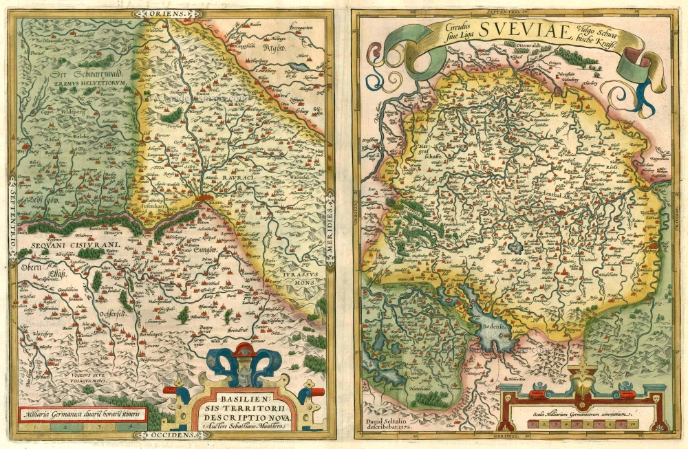
Basiliensis Territorii Descritorii Nova. - Circulus sive Liga Sveviae 1612
Basel and Schwaben by Abraham Ortelius.
[Item number: 22964]
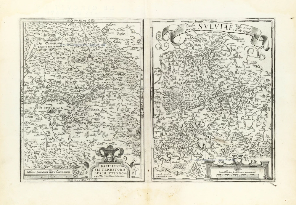
Basiliensis Territorii Descritorii Nova. [on sheet with:] Circulus sive Liga Sveviae Vulgo Schwabische Kraiß. 1581
Basel - Schwaben by Abraham Ortelius.
[Item number: 23034]

Decem et Tria Loca Confoederatorum Helvetiae. 1572-1624
13 bird's-eye views of Swiss cities by Braun and Hogenberg: Schwyz, Unterwalden, Zug, Glarus, Basel, Zurich, Bern, Lucerne, Uri, Fribourg, Solothurn, Schaffhausen and Appenzell.
[Item number: 23230]

Zurych - Tigurum, sive Turegum, Caesari, ut Plerique Existimant, Tigurinus Pagus, vulgo Zurych, Urbs in Helvetijs 1588
Zürich, by Braun & Hogenberg.
[Item number: 25148]

Basiliensis Civitatis contrafactura, adumbrata ad genuinum eius situm, quem anno 1549 habuit. 1552
Basel by S. Munster.
[Item number: 25724]

Unrecorded view of Basel by Carel Allard
Basel. 1673
View of Basel by Carel Allard.
[Item number: 30573]

Basel. 1686
Basel by Christoph Riegel.
[Item number: 31508]