
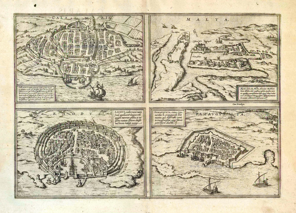
Cagliari, Malta, Rhodos and Famagusta, by Georg Braun and Frans Hogenberg. 1582
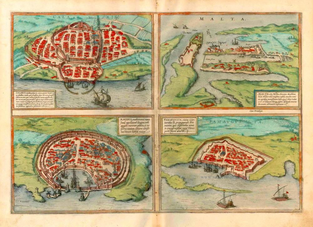


CAGLIARI
TRANSLATION OF CARTOUCHE TEXT: Cagliari, the first city of Sardinia, is divided into four parts. The inner city is surrounded by a very strong wall and is Cagliari proper; the eastern part is the New Town. The part facing south towards the Mediterranean is called La Gliapola or La Marina, and the western part is Stampax. The three last are suburbs and extensions of Cagliari.
COMMENTARY BY BRAUN: "The viceroy or royal governor lives in Cagliari with the counts and barons and other rich lords. However, the city has its government: the King does not involve himself with its affairs, but each year they elect five aldermen who promise the interests of the city and distribute its income for the general good. They have the power to impose regulations on the citizens and to punish criminals with death."
The bird's-eye view of Cagliari clearly shows the division of the city into four parts: the Castello district within the inner city wall, representing the original core, and the three partially walled suburbs of Stampax (Stampace) on the left, Gliapola facing the harbour and Nova Villa, the New Town on the right. Identified within Castello are the Gothic cathedral of Santa Maria di Castello (Bischoflich Kirch), the viceroy's palace (Kunigs Pallast) and the town hall (Rath Hauss). Founded in the 7th century BC, the city served as a major centre of commerce in antiquity. Later ravaged by pirates, in the 11th century, Cagliari became part of the Kingdom of Aragon and the capital of the viceroyalty of Sardinia.
MALTA
CARTOUCHE: Malta, formerly Melita, Malthacia in Antoninus, the best-known island in the Mediterranean, has a well-fortified city of the same name, which in 1565 won immortal fame by defeating the powerful Turkish armada.
COMMENTARY BY BRAUN: "Malta lies in the middle of the sea, like a key at the entrance between Sicily and Africa. On the island there is a city of the same name with a massive, mighty castle, Fort St Elmo; during the Turkish war, a new town was built beside it, where Fort Sant'Angelo and Fort St Michael also stand. This city sheltered both St Paul and the Knights of St John after the Turks had taken Rhodes. In 1565 this Order defended the island from the mighty army and fleet of the Turks with manly courage and bravery and put them to flight."
A schematic drawing shows Malta with a strongly fortified harbour. Fort St Elmo can be seen on the left, with Fort Sant'Angelo across the water to its right and the star-shaped Fort St Michael further right again. The town - indicated in the present plate - that grew up around Fort St Elmo is called Valetta: it was founded in 1566 by Jean Parisot de la Valette, Grand Master of the Order of St John. From 1530 until its conquest by Napoleonic troops in 1789, the island lay under the rule of the Knights Hospitaller, who hence also took the name of the Knights of Malta. Today Valletta is the capital of the Republic of Malta, which comprises the three islands of Malta, Gozo and Comino.
RHODES (RODOS)
CARTOUCHE: Rhodes gives the Mediterranean island its name; a town highly famed for the narrow circumference of its wall and its safe harbour, today it lies under Turkish dominion.
COMMENTARY BY BRAUN: "In earlier times there was a famous school of rhetoric in Rhodes, where amongst others Posidonius the philosopher and Thrasyllus the mathematician and other learned men of high regards were active. Pompey the Great and Emperor Tiberius heard them in Rhodes, as can be read in Cicero's Tusculanae disputationes. Many also went from Athens to Rhodes to study there; M.T. Cicero also sent his son to study here." Rhodes is presented as a circular town with a well-fortified harbour entrance. The town is surrounded by three impressive walls. The windmills just outside the harbour on the left are typical of Greek Islands. The city of Rhodes was designed c.408 BC by Hippodamus of Miletus. The Colossus of Rhodes, which represented the Greek god Helios, patron saint of Rhodes, was erected between 292 and 280 BC and numbered amongst the Seven Wonders of the World. Following the division of the Roman Empire, Rhodes formed part of the Eastern Empire and came under the varying rule of Arab occupying forces and Crusaders. From the 16th century until 1912 it belonged to the Ottoman Empire.
FAMAGUSTA (GAZIMAGUSA)
CARTOUCHE: Famagusta, a city in Cyprus, well fortified with towers and bulwarks, which in earlier years fell under the rule of the ferocious Turks.
COMMENTARY BY BRAUN: "The island of Cyprus, which extends across the Mediterranean between Sicily and Syria and is a splendid kingdom, has two notable cities, namely Nicosia and Famagusta. [...] Famagusta possesses a harbour, as a result of which it became an important centre of commerce on the island. The city is so well fortified from the sea and from the land by Nature, as well as by the Venetians with their building skills, that it can withstand a massive enemy attack with no great damage. The Turk Selim II took both cities and the island from the Venetians, however, and placed them under his rule."
The bird's-eye view shows the city of Famagusta surrounded by a double set of city walls containing private houses and the church of St Nicholas. Famagusta was founded in antiquity under the name of Arsinoe (after Arsinoe II of Egypt) and in the Middle Ages developed into an important centre of trade, where business was transacted above all between Asia, Venice and Genoa. Its geographical location made the city an important strategic base for the Crusaders. In 1374 the Genoese occupied Famagusta and held it until 1571 when it was conquered by the Ottomans. (Taschen)
Braun G. & Hogenberg F. and the Civitates Orbis Terrarum.
The Civitates Orbis Terrarum, also known as the 'Braun & Hogenberg', is a six-volume town atlas and the most excellent book of town views and plans ever published: 363 engravings, sometimes beautifully coloured. It was one of the best-selling works in the last quarter of the 16th century. Georg Braun, a skilled writer, wrote the text accompanying the plans and views on the verso. Many plates were engraved after the original drawings of a professional artist, Joris Hoefnagel (1542-1600). The first volume was published in Latin in 1572 and the sixth in 1617. Frans Hogenberg, a talented engraver, created the tables for volumes I through IV, and Simon van den Neuwel made those for volumes V and VI. Other contributors were cartographers Daniel Freese and Heinrich Rantzau, who provided valuable geographical information. Works by Jacob van Deventer, Sebastian Münster, and Johannes Stumpf were also used as references. Translations appeared in German and French, making the atlas accessible to a wider audience.
Since its original publication of volume 1 in 1572, the Civitates Orbis Terrarum has left an indelible mark on the history of cartography. The first volume was followed by seven more editions in 1575, 1577, 1582, 1588, 1593, 1599, and 1612. Vol.2, initially released in 1575, saw subsequent editions in 1597 and 1612. The subsequent volumes, each a treasure trove of historical insights, graced the world in 1581, 1588, 1593, 1599, and 1606. The German translation of the first volume, a testament to its widespread appeal, debuted in 1574, followed by the French edition in 1575.
Several printers were involved: Theodor Graminaeus, Heinrich von Aich, Gottfried von Kempen, Johannis Sinniger, Bertram Buchholtz, and Peter von Brachel, all of whom worked in Cologne.
Georg Braun (1541-1622)
Georg Braun, the author of the text accompanying the plans and views in the Civitates Orbis Terrarum, was born in Cologne in 1541. After his studies in Cologne, he entered the Jesuit Order as a novice, indicating his commitment to learning and intellectual pursuits. In 1561, he obtained his bachelor's degree; in 1562, he received his Magister Artium, further demonstrating his academic achievements. Although he left the Jesuit Order, he continued his studies in theology, gaining a licentiate in theology. His theological background likely influenced the content and tone of the text in the Civitates Orbis Terrarum, adding a unique perspective to the work.
Frans Hogenberg (1535-1590)
Frans Hogenberg was a Flemish and German painter, engraver, and mapmaker. He was born in Mechelen as the son of Nicolaas Hogenberg.
By the end of the 1560s, Frans Hogenberg was employed upon Abraham Ortelius's Theatrum Orbis Terrarum, published in 1570; he is named an engraver of numerous maps. In 1568, he was banned from Antwerp by the Duke of Alva and travelled to London, where he stayed a few years before emigrating to Cologne. He immediately embarked on his two most important works, the Civitates, published in 1572 and the Geschichtsblätter, which appeared in several series from 1569 until about 1587.
Thanks to large-scale projects like the Geschichtsblätter and the Civitates, Hogenberg's social circumstances improved with each passing year. He died as a wealthy man in Cologne in 1590.
Calaris [on sheet with] Malta [and] Rhodus [and] Famagusta
Item Number: 25318 Authenticity Guarantee
Category: Antique maps > Mediterranean Sea
Four bird's-eye views on one sheet: Cagliari, Malta, Rhodos and Famagusta, by Georg Braun and Frans Hogenberg.
Title: Calaris [on sheet with] Malta [and] Rhodus [and] Famagusta
Date of the first edition: 1572.
Date of this map: 1582.
Copper engraving, printed on paper.
Size (not including margins): 330 x 475mm (12.99 x 18.7 inches).
Verso: Latin text.
Condition: Original coloured, excellent.
Condition Rating: A+.
From: Civitates Orbis Terrarum, Liber Primus. Köln, Gottfried von Kempen, 1582. (Van der Krogt 4, 41:1.1(1582))
CAGLIARI
TRANSLATION OF CARTOUCHE TEXT: Cagliari, the first city of Sardinia, is divided into four parts. The inner city is surrounded by a very strong wall and is Cagliari proper; the eastern part is the New Town. The part facing south towards the Mediterranean is called La Gliapola or La Marina, and the western part is Stampax. The three last are suburbs and extensions of Cagliari.
COMMENTARY BY BRAUN: "The viceroy or royal governor lives in Cagliari with the counts and barons and other rich lords. However, the city has its government: the King does not involve himself with its affairs, but each year they elect five aldermen who promise the interests of the city and distribute its income for the general good. They have the power to impose regulations on the citizens and to punish criminals with death."
The bird's-eye view of Cagliari clearly shows the division of the city into four parts: the Castello district within the inner city wall, representing the original core, and the three partially walled suburbs of Stampax (Stampace) on the left, Gliapola facing the harbour and Nova Villa, the New Town on the right. Identified within Castello are the Gothic cathedral of Santa Maria di Castello (Bischoflich Kirch), the viceroy's palace (Kunigs Pallast) and the town hall (Rath Hauss). Founded in the 7th century BC, the city served as a major centre of commerce in antiquity. Later ravaged by pirates, in the 11th century, Cagliari became part of the Kingdom of Aragon and the capital of the viceroyalty of Sardinia.
MALTA
CARTOUCHE: Malta, formerly Melita, Malthacia in Antoninus, the best-known island in the Mediterranean, has a well-fortified city of the same name, which in 1565 won immortal fame by defeating the powerful Turkish armada.
COMMENTARY BY BRAUN: "Malta lies in the middle of the sea, like a key at the entrance between Sicily and Africa. On the island there is a city of the same name with a massive, mighty castle, Fort St Elmo; during the Turkish war, a new town was built beside it, where Fort Sant'Angelo and Fort St Michael also stand. This city sheltered both St Paul and the Knights of St John after the Turks had taken Rhodes. In 1565 this Order defended the island from the mighty army and fleet of the Turks with manly courage and bravery and put them to flight."
A schematic drawing shows Malta with a strongly fortified harbour. Fort St Elmo can be seen on the left, with Fort Sant'Angelo across the water to its right and the star-shaped Fort St Michael further right again. The town - indicated in the present plate - that grew up around Fort St Elmo is called Valetta: it was founded in 1566 by Jean Parisot de la Valette, Grand Master of the Order of St John. From 1530 until its conquest by Napoleonic troops in 1789, the island lay under the rule of the Knights Hospitaller, who hence also took the name of the Knights of Malta. Today Valletta is the capital of the Republic of Malta, which comprises the three islands of Malta, Gozo and Comino.
RHODES (RODOS)
CARTOUCHE: Rhodes gives the Mediterranean island its name; a town highly famed for the narrow circumference of its wall and its safe harbour, today it lies under Turkish dominion.
COMMENTARY BY BRAUN: "In earlier times there was a famous school of rhetoric in Rhodes, where amongst others Posidonius the philosopher and Thrasyllus the mathematician and other learned men of high regards were active. Pompey the Great and Emperor Tiberius heard them in Rhodes, as can be read in Cicero's Tusculanae disputationes. Many also went from Athens to Rhodes to study there; M.T. Cicero also sent his son to study here." Rhodes is presented as a circular town with a well-fortified harbour entrance. The town is surrounded by three impressive walls. The windmills just outside the harbour on the left are typical of Greek Islands. The city of Rhodes was designed c.408 BC by Hippodamus of Miletus. The Colossus of Rhodes, which represented the Greek god Helios, patron saint of Rhodes, was erected between 292 and 280 BC and numbered amongst the Seven Wonders of the World. Following the division of the Roman Empire, Rhodes formed part of the Eastern Empire and came under the varying rule of Arab occupying forces and Crusaders. From the 16th century until 1912 it belonged to the Ottoman Empire.
FAMAGUSTA (GAZIMAGUSA)
CARTOUCHE: Famagusta, a city in Cyprus, well fortified with towers and bulwarks, which in earlier years fell under the rule of the ferocious Turks.
COMMENTARY BY BRAUN: "The island of Cyprus, which extends across the Mediterranean between Sicily and Syria and is a splendid kingdom, has two notable cities, namely Nicosia and Famagusta. [...] Famagusta possesses a harbour, as a result of which it became an important centre of commerce on the island. The city is so well fortified from the sea and from the land by Nature, as well as by the Venetians with their building skills, that it can withstand a massive enemy attack with no great damage. The Turk Selim II took both cities and the island from the Venetians, however, and placed them under his rule."
The bird's-eye view shows the city of Famagusta surrounded by a double set of city walls containing private houses and the church of St Nicholas. Famagusta was founded in antiquity under the name of Arsinoe (after Arsinoe II of Egypt) and in the Middle Ages developed into an important centre of trade, where business was transacted above all between Asia, Venice and Genoa. Its geographical location made the city an important strategic base for the Crusaders. In 1374 the Genoese occupied Famagusta and held it until 1571 when it was conquered by the Ottomans. (Taschen)
Braun G. & Hogenberg F. and the Civitates Orbis Terrarum.
The Civitates Orbis Terrarum, also known as the 'Braun & Hogenberg', is a six-volume town atlas and the most excellent book of town views and plans ever published: 363 engravings, sometimes beautifully coloured. It was one of the best-selling works in the last quarter of the 16th century. Georg Braun, a skilled writer, wrote the text accompanying the plans and views on the verso. Many plates were engraved after the original drawings of a professional artist, Joris Hoefnagel (1542-1600). The first volume was published in Latin in 1572 and the sixth in 1617. Frans Hogenberg, a talented engraver, created the tables for volumes I through IV, and Simon van den Neuwel made those for volumes V and VI. Other contributors were cartographers Daniel Freese and Heinrich Rantzau, who provided valuable geographical information. Works by Jacob van Deventer, Sebastian Münster, and Johannes Stumpf were also used as references. Translations appeared in German and French, making the atlas accessible to a wider audience.
Since its original publication of volume 1 in 1572, the Civitates Orbis Terrarum has left an indelible mark on the history of cartography. The first volume was followed by seven more editions in 1575, 1577, 1582, 1588, 1593, 1599, and 1612. Vol.2, initially released in 1575, saw subsequent editions in 1597 and 1612. The subsequent volumes, each a treasure trove of historical insights, graced the world in 1581, 1588, 1593, 1599, and 1606. The German translation of the first volume, a testament to its widespread appeal, debuted in 1574, followed by the French edition in 1575.
Several printers were involved: Theodor Graminaeus, Heinrich von Aich, Gottfried von Kempen, Johannis Sinniger, Bertram Buchholtz, and Peter von Brachel, all of whom worked in Cologne.
Georg Braun (1541-1622)
Georg Braun, the author of the text accompanying the plans and views in the Civitates Orbis Terrarum, was born in Cologne in 1541. After his studies in Cologne, he entered the Jesuit Order as a novice, indicating his commitment to learning and intellectual pursuits. In 1561, he obtained his bachelor's degree; in 1562, he received his Magister Artium, further demonstrating his academic achievements. Although he left the Jesuit Order, he continued his studies in theology, gaining a licentiate in theology. His theological background likely influenced the content and tone of the text in the Civitates Orbis Terrarum, adding a unique perspective to the work.
Frans Hogenberg (1535-1590)
Frans Hogenberg was a Flemish and German painter, engraver, and mapmaker. He was born in Mechelen as the son of Nicolaas Hogenberg.
By the end of the 1560s, Frans Hogenberg was employed upon Abraham Ortelius's Theatrum Orbis Terrarum, published in 1570; he is named an engraver of numerous maps. In 1568, he was banned from Antwerp by the Duke of Alva and travelled to London, where he stayed a few years before emigrating to Cologne. He immediately embarked on his two most important works, the Civitates, published in 1572 and the Geschichtsblätter, which appeared in several series from 1569 until about 1587.
Thanks to large-scale projects like the Geschichtsblätter and the Civitates, Hogenberg's social circumstances improved with each passing year. He died as a wealthy man in Cologne in 1590.
Related items
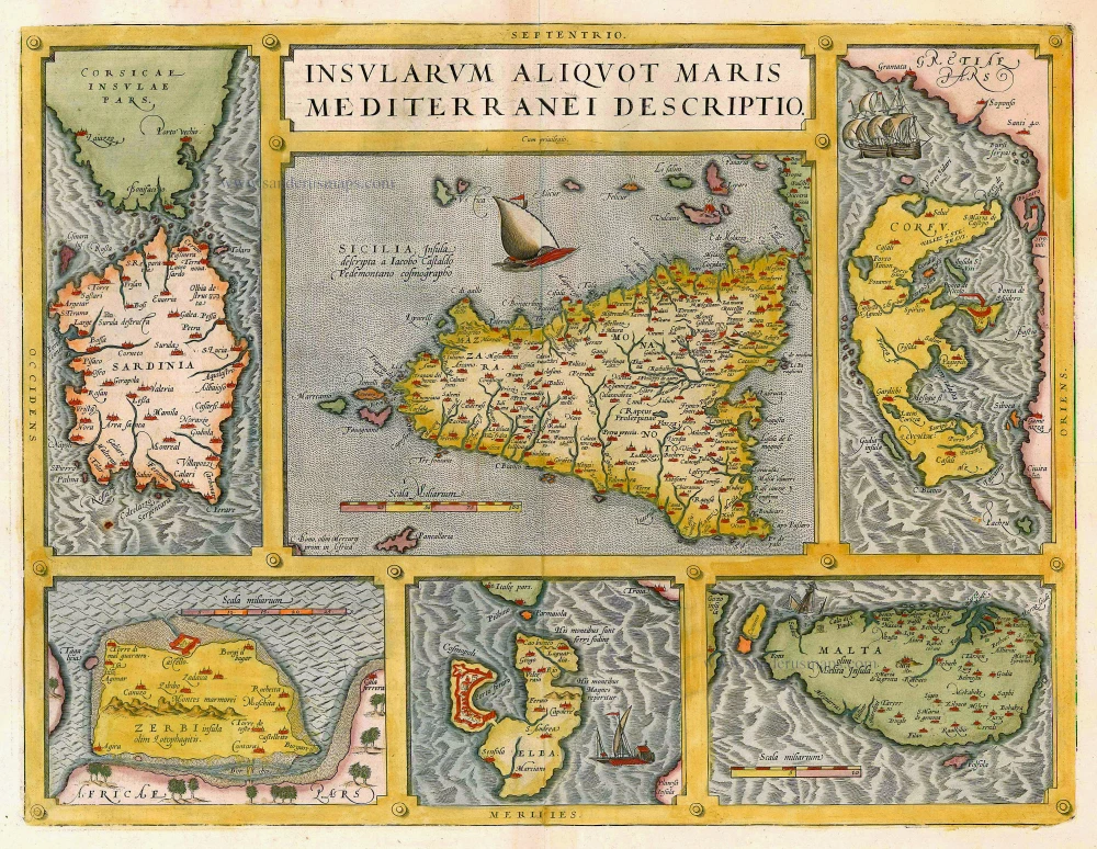
Insularum Aliquot Maris Mediterranei Descriptio. 1612
Sicily, Sardinia, Corfu, Djerba, Elba, Malta by Abraham Ortelius
[Item number: 20929]
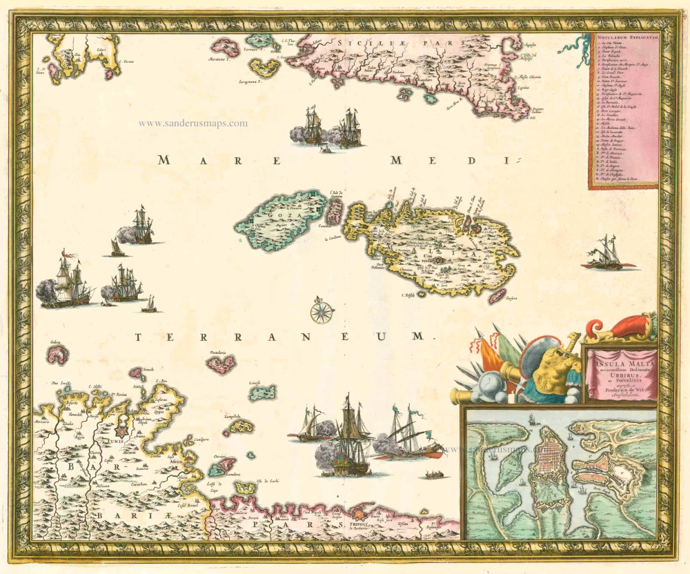
Insula Malta Accuratissime Delineata, Urbibus et Fortalitiis c. 1680
MALTA by Frederik De Wit
[Item number: 24657]
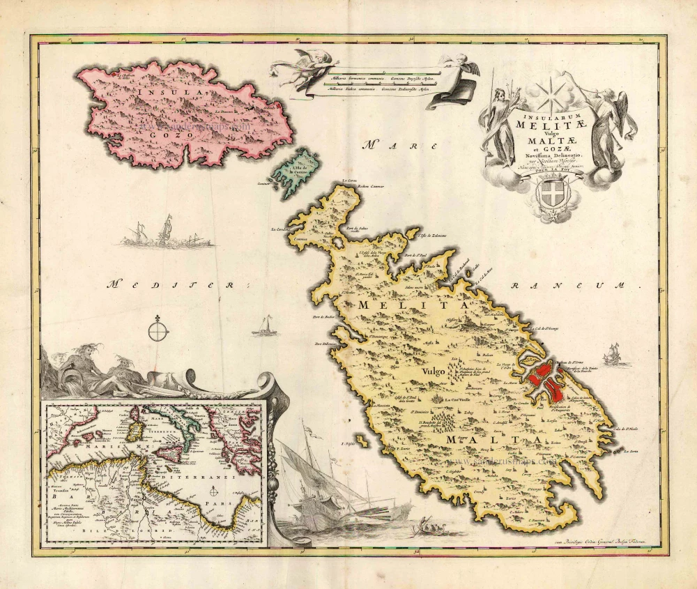
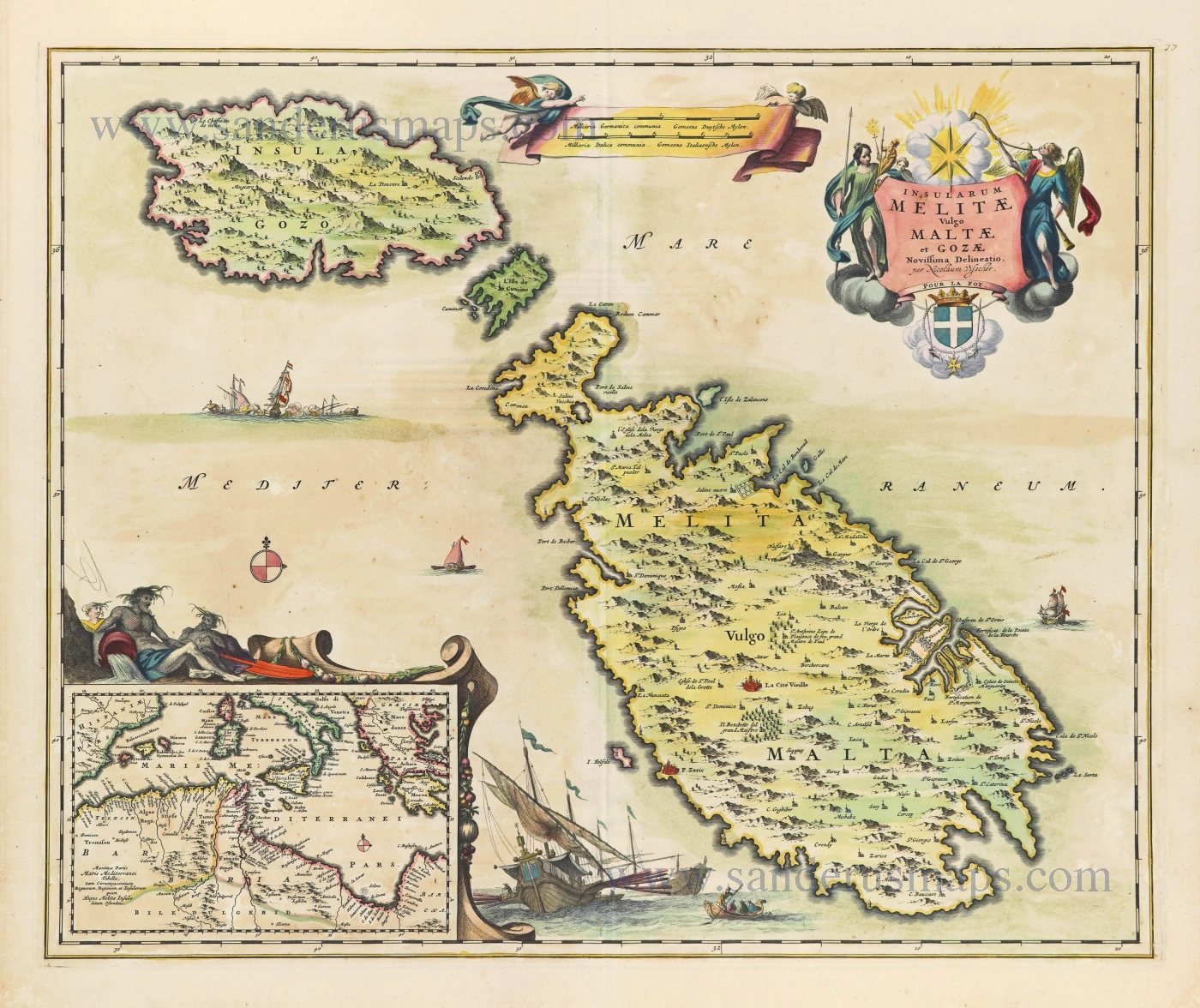
Insularum Melitae vulgo Maltae et Gozae Novissima Delineatio. c. 1700
Malta & Gozo, by N. Visscher, published by P. Schenk.
[Item number: 25697]
Very rare!
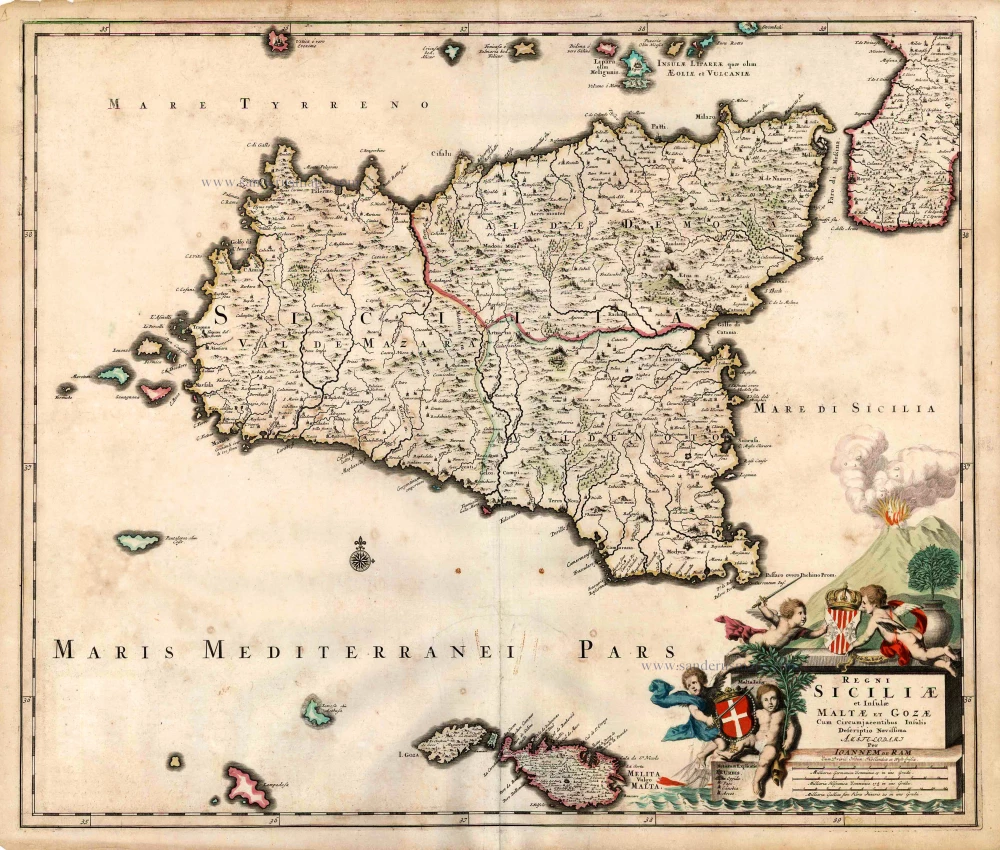
Regni Siciliae et Insulae Maltae et Gozae Cum Circumjacentibus Insulis. c. 1690
Sicily by Johannes De Ram.
[Item number: 26726]
Calaris [on sheet with] Malta [and] Rhodus [and] Famagusta. 1612
Cagliari - Malta - Rhodos - Famagusta, by Georg Braun & Frans Hogenberg.
[Item number: 26910]
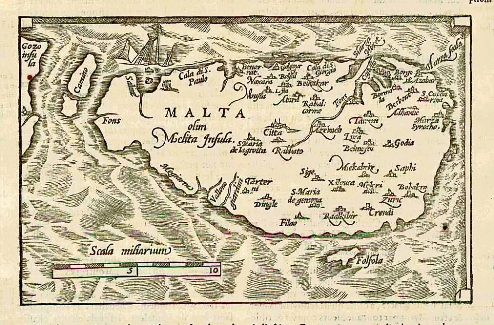
Malta olim Melita insula. 1575
Malta, by François de Belleforest.
[Item number: 27329]
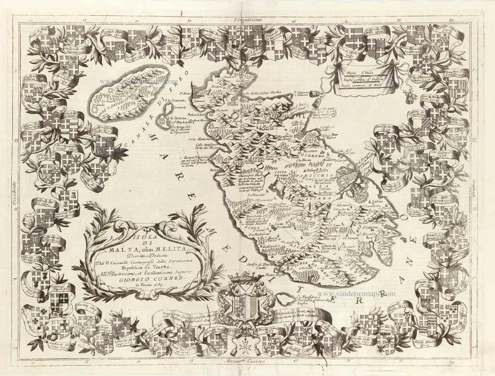
Insularum Melitae vulgo Maltae et Gozae. c. 1680
Malta & Gozo, by Nicolaes Visscher I.
[Item number: 28578]
Isola di Malta olim Melita. 1696
Malta by Vincenzo Coronelli.
[Item number: 28817]
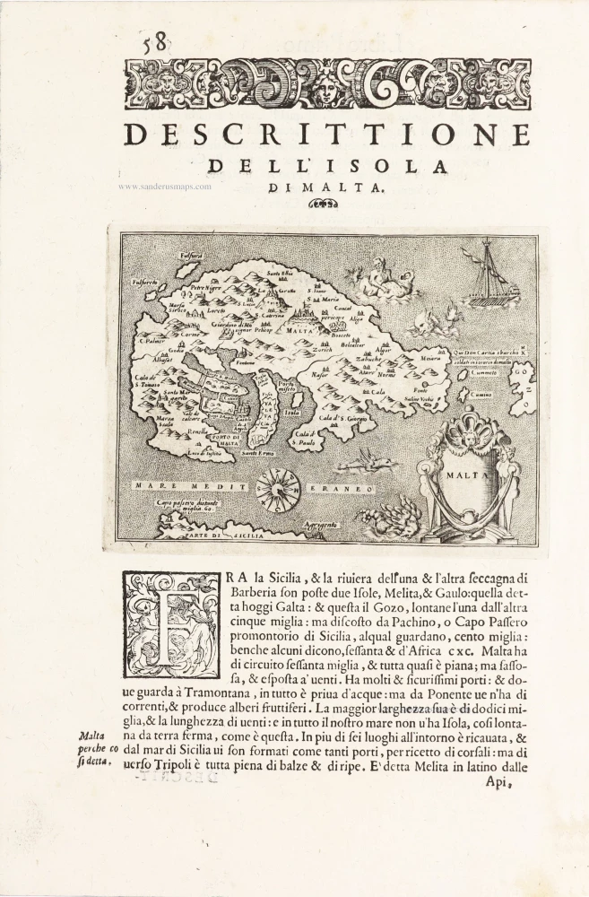
Malta - [Above map :] Descrittione dell'Isola di Malta. 1590
Malta by Thomaso Porcacchi.
[Item number: 29767]